Bridge Statistics for Norphlet, Arkansas (AR)
Condition, Traffic, Stress, Structural Evaluation, Project Costs
- National Bridge Inventory (NBI) Statistics
- 23Number of bridges
- 246ft / 74.7mTotal length
- $106,000Total costs
- 27,540Total average daily traffic
- 1,262Total average daily truck traffic
- 16,694Total future (year 2004) average daily traffic
- National Bridge Inventory (NBI) Registered Bridges for Norphlet
- No street view available for this location
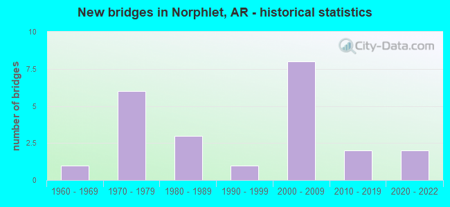
- New bridges - historical statistics
- 11960-1969
- 61970-1979
- 31980-1989
- 11990-1999
- 82000-2009
- 22010-2019
- 22020-2022

- Reconstructed bridges - Historical Statistics
- 21990-1999
- 12000-2009


- Bridge Condition - Deck
- 4.5%Excellent
- 18.2%Very good
- 59.1%Good
- 18.2%Satisfactory

- Bridge Condition - Superstructure
- 4.5%Excellent
- 18.2%Very good
- 59.1%Good
- 18.2%Satisfactory

- Bridge Condition - Substructure
- 4.5%Excellent
- 40.9%Very good
- 40.9%Good
- 13.6%Satisfactory

- Bridge Condition - Channel
- 34.8%Very good
- 43.5%Good
- 17.4%Satisfactory
- 4.3%Fair
Find on map >> Show street view
Structure Number: 4151, Location: .05 M N UNION CO LINE (Lat: 33.368481, Lng: -92.648400), Route carried "on" structure: County highway 68, Year Built: 1960, Year Reconstructed: 1995, Status: Open, Structure Length: 2.90m (9.51ft), Average Daily Traffic: 641 (year 2018), Truck Traffic: 1%, Average Future Daily Traffic: 108 (year 2007), Design Load: H 15, Features Intersected: SMACKOVER CREEK RELIEF
Minimum Vertical Clearance: 30+ m (98+ ft), Kilometerpoint: 0.080, Lanes on structure: 2, Owner: County Highway Agency, Approaching Roadway Width: 8.5m (27.9ft), Material/Design: Concrete, Design/Construction: Channel Beam, Number Of Spans In Main Unit: 5, Length of Maximum Span: 5.8m (19.0ft), Curb-To-Curb Width: 7.4m (24.3ft), Out-to-Out Width: 7.7m (25.3ft)
Condition: Deck: Good, Superstructure: Good, Substructure: Satisfactory, Channel: Satisfactory, Operating Rating: 54.4 metric tons, Method Used To Determine Operating Rating: Load Factor (LF), Inventory Rating: 32.7 metric tons, Method Used To Determine Inventory Rating: Load Factor (LF), Structural Evaluation: Equal to present minimum criteria, Deck Geometry: Meets minimum limits, Waterway Adequacy: Equal to present minimum criteria, Approach Roadway Alignment: Better than present minimum criteria, Length Of Structure Improvement: 2.90m (9.51ft), Designated Inspection Frequency: Every 24 months, Critical Feature Inspection Frequency: Every 24 months, Inspection Date: September 2021, Total Project Cost: $106,000, Deck Structure Type: Concrete Precast Panels, Wearing Surface/Protective System: Wearing Surface: Bituminous
Find on map >> Show street view
Structure Number: 4252, Location: .75 M E JCT CR 15 & 500 (Lat: 33.357486, Lng: -92.686286), Route carried "on" structure: County highway 15, Year Built: 1974, Year Reconstructed: 2007, Status: Open, Structure Length: 2.83m (9.28ft), Average Daily Traffic: 527 (year 2018), Truck Traffic: 1%, Average Future Daily Traffic: 427 (year 2004), Design Load: H 15, Features Intersected: SMACKOVER CREEK RELIEF
Minimum Vertical Clearance: 30+ m (98+ ft), Kilometerpoint: 3.458, Lanes on structure: 2, Owner: County Highway Agency, Approaching Roadway Width: 7.6m (24.9ft), Material/Design: Concrete, Design/Construction: Channel Beam, Number Of Spans In Main Unit: 3, Length of Maximum Span: 9.4m (30.8ft), Curb-To-Curb Width: 7.4m (24.3ft), Out-to-Out Width: 8.0m (26.2ft)
Condition: Deck: Good, Superstructure: Good, Substructure: Very good, Channel: Good, Operating Rating: 46.3 metric tons, Method Used To Determine Operating Rating: Load Factor (LF), Inventory Rating: 28.1 metric tons, Method Used To Determine Inventory Rating: Load Factor (LF), Structural Evaluation: Better than present minimum criteria, Deck Geometry: Meets minimum limits, Waterway Adequacy: Better than present minimum criteria, Approach Roadway Alignment: Better than present minimum criteria, Designated Inspection Frequency: Every 24 months, Critical Feature Inspection Frequency: Every 24 months, Inspection Date: June 2021, Deck Structure Type: Concrete Precast Panels, Wearing Surface/Protective System: Wearing Surface: Monolithic Concrete
Find on map >> Show street view
Structure Number: 4266, Location: Union & Ouachita Co Line (Lat: 33.367219, Lng: -92.647569), Route carried "on" structure: County highway 68, Year Built: 1975, Status: Open, Structure Length: 6.86m (22.51ft), Average Daily Traffic: 151 (year 2018), Truck Traffic: 1%, Average Future Daily Traffic: 108 (year 2007), Design Load: H 20, Features Intersected: SMACKOVER CREEK
Minimum Vertical Clearance: 30+ m (98+ ft), Kilometerpoint: 0.002, Lanes on structure: 2, Owner: County Highway Agency, Approaching Roadway Width: 11.0m (36.1ft), Material/Design: Concrete, Design/Construction: Channel Beam, Number Of Spans In Main Unit: 5, Length of Maximum Span: 13.7m (44.9ft), Curb-To-Curb Width: 9.3m (30.5ft), Out-to-Out Width: 9.9m (32.5ft)
Condition: Deck: Good, Superstructure: Good, Substructure: Satisfactory, Channel: Satisfactory, Operating Rating: 39.0 metric tons, Method Used To Determine Operating Rating: Load Factor (LF), Inventory Rating: 23.6 metric tons, Method Used To Determine Inventory Rating: Load Factor (LF), Structural Evaluation: Equal to present minimum criteria, Deck Geometry: Equal to present minimum criteria, Waterway Adequacy: Better than present minimum criteria, Approach Roadway Alignment: Equal to present desirable criteria, Designated Inspection Frequency: Every 24 months, Critical Feature Inspection Frequency: Every 24 months, Inspection Date: March 2020, Deck Structure Type: Concrete Precast Panels, Wearing Surface/Protective System: Wearing Surface: Bituminous
Find on map >> Show street view
Structure Number: 4267, Location: 1 M E JCT CR 500 (Lat: 33.359900, Lng: -92.682269), Route carried "on" structure: County highway 15, Year Built: 1975, Status: Open, Structure Length: 6.86m (22.51ft), Average Daily Traffic: 527 (year 2018), Truck Traffic: 1%, Average Future Daily Traffic: 427 (year 2004), Design Load: H 20, Features Intersected: SMACKOVER CREEK
Minimum Vertical Clearance: 30+ m (98+ ft), Kilometerpoint: 3.941, Lanes on structure: 2, Owner: County Highway Agency, Approaching Roadway Width: 8.5m (27.9ft), Material/Design: Concrete, Design/Construction: Channel Beam, Number Of Spans In Main Unit: 5, Length of Maximum Span: 13.7m (44.9ft), Curb-To-Curb Width: 8.3m (27.2ft), Out-to-Out Width: 8.9m (29.2ft)
Condition: Deck: Good, Superstructure: Good, Substructure: Good, Channel: Satisfactory, Operating Rating: 35.4 metric tons, Method Used To Determine Operating Rating: Load Factor (LF), Inventory Rating: 20.9 metric tons, Method Used To Determine Inventory Rating: Load Factor (LF), Structural Evaluation: Somewhat better than minimum adequacy, Deck Geometry: Somewhat better than minimum adequacy, Waterway Adequacy: Better than present minimum criteria, Approach Roadway Alignment: Better than present minimum criteria, Designated Inspection Frequency: Every 24 months, Critical Feature Inspection Frequency: Every 24 months, Inspection Date: October 2020, Deck Structure Type: Concrete Precast Panels, Wearing Surface/Protective System: Wearing Surface: Monolithic Concrete
Find on map >> Show street view
Structure Number: 4268, Location: .84 MI N UNION CO LINE (Lat: 33.368347, Lng: -92.672678), Route carried "on" structure: County highway 69, Year Built: 1980, Status: Open, Structure Length: 6.61m (21.69ft), Average Daily Traffic: 11 (year 2018), Truck Traffic: 1%, Average Future Daily Traffic: 281 (year 2007), Design Load: H 20, Features Intersected: SMACKOVER CR RELIEF, Facility Carried by Structure: Oua.CR 448 Z-A
Minimum Vertical Clearance: 30+ m (98+ ft), Kilometerpoint: 1.352, Lanes on structure: 2, Owner: County Highway Agency, Approaching Roadway Width: 6.1m (20.0ft), Material/Design: Concrete, Design/Construction: Channel Beam, Number Of Spans In Main Unit: 7, Length of Maximum Span: 9.4m (30.8ft), Curb-To-Curb Width: 8.5m (27.9ft), Out-to-Out Width: 9.4m (30.8ft)
Condition: Deck: Good, Superstructure: Good, Substructure: Very good, Channel: Very good, Operating Rating: 54.4 metric tons, Method Used To Determine Operating Rating: Load Factor (LF), Inventory Rating: 32.7 metric tons, Method Used To Determine Inventory Rating: Load Factor (LF), Structural Evaluation: Better than present minimum criteria, Deck Geometry: Better than present minimum criteria, Waterway Adequacy: Equal to present desirable criteria, Approach Roadway Alignment: Better than present minimum criteria, Designated Inspection Frequency: Every 24 months, Critical Feature Inspection Frequency: Every 24 months, Inspection Date: March 2020, Deck Structure Type: Concrete Precast Panels, Wearing Surface/Protective System: Wearing Surface: Monolithic Concrete
Find on map >> Show street view
Structure Number: 4358, Location: 1.68 MI NW JCT US 167 (Lat: 33.304489, Lng: -92.624650), Route carried "on" structure: County highway 18, Year Built: 1978, Status: Open, Structure Length: 3.78m (12.40ft), Average Daily Traffic: 635 (year 2018), Truck Traffic: 1%, Average Future Daily Traffic: 159 (year 2007), Design Load: H 15, Features Intersected: SALT CREEK
Minimum Vertical Clearance: 30+ m (98+ ft), Kilometerpoint: 2.704, Lanes on structure: 2, Owner: County Highway Agency, Approaching Roadway Width: 7.9m (25.9ft), Material/Design: Concrete, Design/Construction: Channel Beam, Number Of Spans In Main Unit: 4, Length of Maximum Span: 9.4m (30.8ft), Curb-To-Curb Width: 7.4m (24.3ft), Out-to-Out Width: 8.0m (26.2ft)
Condition: Deck: Good, Superstructure: Good, Substructure: Satisfactory, Channel: Fair, Operating Rating: 54.4 metric tons, Method Used To Determine Operating Rating: Load Factor (LF), Inventory Rating: 32.7 metric tons, Method Used To Determine Inventory Rating: Load Factor (LF), Structural Evaluation: Equal to present minimum criteria, Deck Geometry: Meets minimum limits, Waterway Adequacy: Equal to present minimum criteria, Approach Roadway Alignment: Equal to present desirable criteria, Designated Inspection Frequency: Every 24 months, Critical Feature Inspection Frequency: Every 24 months, Inspection Date: November 2020, Deck Structure Type: Concrete Precast Panels, Wearing Surface/Protective System: Wearing Surface: Monolithic Concrete
Find on map >> Show street view
Structure Number: 4715, Location: 0.31 MI N UNION CO LINE (Lat: 33.371469, Lng: -92.650219), Route carried "on" structure: County highway 68, Year Built: 1994, Status: Open, Structure Length: 4.72m (15.49ft), Average Daily Traffic: 641 (year 2018), Truck Traffic: 1%, Average Future Daily Traffic: 344 (year 2012), Design Load: HS 20, Features Intersected: SMACKOVER CK RELIEF
Minimum Vertical Clearance: 30+ m (98+ ft), Kilometerpoint: 0.499, Lanes on structure: 2, Owner: County Highway Agency, Approaching Roadway Width: 9.1m (29.9ft), Material/Design: Concrete, Design/Construction: Channel Beam, Number Of Spans In Main Unit: 5, Length of Maximum Span: 9.4m (30.8ft), Curb-To-Curb Width: 8.6m (28.2ft), Out-to-Out Width: 9.4m (30.8ft)
Condition: Deck: Good, Superstructure: Good, Substructure: Very good, Channel: Very good, Operating Rating: 54.4 metric tons, Method Used To Determine Operating Rating: Load Factor (LF), Inventory Rating: 32.7 metric tons, Method Used To Determine Inventory Rating: Load Factor (LF), Structural Evaluation: Better than present minimum criteria, Deck Geometry: Somewhat better than minimum adequacy, Waterway Adequacy: Equal to present desirable criteria, Approach Roadway Alignment: Somewhat better than minimum adequacy, Designated Inspection Frequency: Every 24 months, Critical Feature Inspection Frequency: Every 24 months, Inspection Date: July 2020, Deck Structure Type: Concrete Precast Panels, Wearing Surface/Protective System: Wearing Surface: Monolithic Concrete
Find on map >> Show street view
Structure Number: 5221, Location: 0.3 MI N JCT SH 7 & 355 (Lat: 33.291969, Lng: -92.675339), Route carried "on" structure: State highway 7, Year Built: 1972, Status: Open, Structure Length: 2.56m (8.40ft), Average Daily Traffic: 9,993 (year 2018), Truck Traffic: 1%, Average Future Daily Traffic: 5,019 (year 2028), Design Load: HS 20, Features Intersected: GOODWIN CREEK
Minimum Vertical Clearance: 30+ m (98+ ft), Kilometerpoint: 5.134, Lanes on structure: 2, Base Highway Network: Yes, Owner: State Highway Agency, Approaching Roadway Width: 13.4m (44.0ft), Material/Design: Concrete, Design/Construction: Slab, Number Of Spans In Main Unit: 3, Length of Maximum Span: 8.5m (27.9ft), Curb-To-Curb Width: 13.1m (43.0ft), Out-to-Out Width: 14.0m (45.9ft)
Condition: Deck: Satisfactory, Superstructure: Satisfactory, Substructure: Good, Channel: Good, Operating Rating: 53.5 metric tons, Method Used To Determine Operating Rating: Load Factor (LF), Inventory Rating: 31.8 metric tons, Method Used To Determine Inventory Rating: Load Factor (LF), Structural Evaluation: Equal to present minimum criteria, Deck Geometry: Superior to present desirable criteria, Waterway Adequacy: Equal to present desirable criteria, Approach Roadway Alignment: Equal to present desirable criteria, Designated Inspection Frequency: Every 24 months, Critical Feature Inspection Frequency: Every 24 months, Inspection Date: April 2020, Deck Structure Type: Concrete Cast-file-Place, Wearing Surface/Protective System: Wearing Surface: Monolithic Concrete
Find on map >> Show street view
Structure Number: 5907, Location: .3 MI N JCT SH7&355 (Lat: 33.292050, Lng: -92.675150), Route carried "on" structure: State highway 7, Year Built: 1984, Status: Open, Structure Length: 2.74m (8.99ft), Average Daily Traffic: 9,993 (year 2018), Truck Traffic: 11%, Average Future Daily Traffic: 5,019 (year 2028), Design Load: HS 20, Features Intersected: GOODWIN CREEK
Minimum Vertical Clearance: 30+ m (98+ ft), Kilometerpoint: 5.150, Lanes on structure: 2, Base Highway Network: Yes, Owner: State Highway Agency, Approaching Roadway Width: 11.6m (38.1ft), Skew: 2 degrees, Material/Design: Concrete, Design/Construction: Slab, Number Of Spans In Main Unit: 3, Length of Maximum Span: 9.1m (29.9ft), Curb-To-Curb Width: 12.2m (40.0ft), Out-to-Out Width: 13.0m (42.7ft)
Condition: Deck: Good, Superstructure: Good, Substructure: Very good, Channel: Good, Operating Rating: 54.4 metric tons, Method Used To Determine Operating Rating: Load Factor (LF), Inventory Rating: 32.7 metric tons, Method Used To Determine Inventory Rating: Load Factor (LF), Structural Evaluation: Better than present minimum criteria, Deck Geometry: Better than present minimum criteria, Waterway Adequacy: Equal to present desirable criteria, Approach Roadway Alignment: Equal to present desirable criteria, Designated Inspection Frequency: Every 24 months, Critical Feature Inspection Frequency: Every 24 months, Inspection Date: April 2020, Deck Structure Type: Concrete Cast-file-Place, Wearing Surface/Protective System: Wearing Surface: Monolithic Concrete
Find on map >> Show street view
Structure Number: 6204, Location: 1 MI S & MI E WRM SPGS (Lat: 36.468581, Lng: -91.038869), Route carried "on" structure: State highway 251, Year Built: 1987, Status: Open, Structure Length: 5.55m (18.21ft), Average Daily Traffic: 230 (year 2018), Truck Traffic: 1%, Average Future Daily Traffic: 758 (year 2028), Design Load: HS 20, Features Intersected: NO BRANCH MUD CREEK
Minimum Vertical Clearance: 30+ m (98+ ft), Kilometerpoint: 20.793, Lanes on structure: 2, Owner: State Highway Agency, Approaching Roadway Width: 9.8m (32.2ft), Material/Design: Steel, Design/Construction: Stringer/Multi-beam, Number Of Spans In Main Unit: 4, Length of Maximum Span: 13.7m (44.9ft), Curb-To-Curb Width: 8.5m (27.9ft), Out-to-Out Width: 9.4m (30.8ft)
Condition: Deck: Good, Superstructure: Good, Substructure: Good, Channel: Good, Operating Rating: 54.4 metric tons, Method Used To Determine Operating Rating: Load Factor (LF), Inventory Rating: 32.7 metric tons, Method Used To Determine Inventory Rating: Load Factor (LF), Structural Evaluation: Better than present minimum criteria, Deck Geometry: Equal to present minimum criteria, Waterway Adequacy: Equal to present desirable criteria, Approach Roadway Alignment: Equal to present desirable criteria, Designated Inspection Frequency: Every 24 months, Critical Feature Inspection Frequency: Every 24 months, Inspection Date: January 2022, Deck Structure Type: Concrete Cast-file-Place, Wearing Surface/Protective System: Wearing Surface: Monolithic Concrete
Find on map >> Show street view
Structure Number: 7466, Location: 1.5 Mi E of Norphlet (Lat: 33.323419, Lng: -92.623358), Route carried "on" structure: State highway 335, Year Built: 2021, Status: Open, Structure Length: 7.94m (26.05ft), Average Daily Traffic: 480 (year 2014), Average Future Daily Traffic: 673 (year 2028), Design Load: HL 93, Features Intersected: Haynes Creek
Minimum Vertical Clearance: 30+ m (98+ ft), Kilometerpoint: 7.258, Lanes on structure: 2, Owner: State Highway Agency, Approaching Roadway Width: 9.1m (29.9ft), Material/Design: Prestressed concrete, Design/Construction: Stringer/Multi-beam, Number Of Spans In Main Unit: 4, Length of Maximum Span: 19.8m (65.0ft), Curb-To-Curb Width: 9.1m (29.9ft), Out-to-Out Width: 10.1m (33.1ft)
Condition: Deck: Excellent, Superstructure: Excellent, Substructure: Excellent, Channel: Very good, Operating Rating: 54.4 metric tons, Method Used To Determine Operating Rating: Load and Resistance Factor (LRFR), Inventory Rating: 32.7 metric tons, Method Used To Determine Inventory Rating: Load and Resistance Factor (LRFR), Structural Evaluation: Superior to present desirable criteria, Deck Geometry: Equal to present minimum criteria, Waterway Adequacy: Better than present minimum criteria, Approach Roadway Alignment: Equal to present desirable criteria, Designated Inspection Frequency: Every 24 months, Critical Feature Inspection Frequency: Every 24 months, Inspection Date: March 2021, Deck Structure Type: Concrete Cast-file-Place, Wearing Surface/Protective System: Wearing Surface: Monolithic Concrete
Find on map >> Show street view
Structure Number: 17253, Location: 3.9MI SE CORD 17 (Lat: 33.330461, Lng: -92.645675), Route carried "on" structure: County highway 77, Year Built: 1974, Year Reconstructed: 2003, Status: Open, Structure Length: 1.74m (5.71ft), Average Daily Traffic: 313 (year 2018), Truck Traffic: 1%, Average Future Daily Traffic: 186 (year 2007), Design Load: H 15, Features Intersected: CREEK
Minimum Vertical Clearance: 30+ m (98+ ft), Kilometerpoint: 6.275, Lanes on structure: 2, Owner: County Highway Agency, Approaching Roadway Width: 6.7m (22.0ft), Material/Design: Concrete, Design/Construction: Channel Beam, Number Of Spans In Main Unit: 3, Length of Maximum Span: 5.8m (19.0ft), Curb-To-Curb Width: 7.3m (24.0ft), Out-to-Out Width: 7.7m (25.3ft)
Condition: Deck: Good, Superstructure: Good, Substructure: Good, Channel: Good, Operating Rating: 38.1 metric tons, Method Used To Determine Operating Rating: Load Factor (LF), Inventory Rating: 22.7 metric tons, Method Used To Determine Inventory Rating: Load Factor (LF), Structural Evaluation: Equal to present minimum criteria, Deck Geometry: Somewhat better than minimum adequacy, Waterway Adequacy: Better than present minimum criteria, Approach Roadway Alignment: Better than present minimum criteria, Designated Inspection Frequency: Every 24 months, Critical Feature Inspection Frequency: Every 24 months, Inspection Date: November 2021, Deck Structure Type: Concrete Precast Panels, Wearing Surface/Protective System: Wearing Surface: Monolithic Concrete
Find on map >> Show street view
Structure Number: 2226, Location: 1.83 MI NW JCT US 167 (Lat: 33.303950, Lng: -92.626097), Route carried "on" structure: County highway 18, Year Built: 2000, Status: Open, Structure Length: 1.52m (4.99ft), Average Daily Traffic: 635 (year 2018), Truck Traffic: 1%, Average Future Daily Traffic: 159 (year 2007), Design Load: H 15, Features Intersected: FLAT CREEK RELIEF
Minimum Vertical Clearance: 30+ m (98+ ft), Kilometerpoint: 2.943, Lanes on structure: 2, Owner: County Highway Agency, Approaching Roadway Width: 8.5m (27.9ft), Material/Design: Concrete, Design/Construction: Channel Beam, Number Of Spans In Main Unit: 2, Length of Maximum Span: 7.6m (24.9ft), Curb-To-Curb Width: 7.3m (24.0ft), Out-to-Out Width: 7.7m (25.3ft)
Condition: Deck: Very good, Superstructure: Very good, Substructure: Very good, Channel: Very good, Operating Rating: 54.4 metric tons, Method Used To Determine Operating Rating: Load Factor (LF), Inventory Rating: 32.7 metric tons, Method Used To Determine Inventory Rating: Load Factor (LF), Structural Evaluation: Equal to present desirable criteria, Deck Geometry: Meets minimum limits, Waterway Adequacy: Equal to present desirable criteria, Approach Roadway Alignment: Equal to present desirable criteria, Designated Inspection Frequency: Every 24 months, Critical Feature Inspection Frequency: Every 24 months, Inspection Date: November 2020, Deck Structure Type: Concrete Precast Panels, Wearing Surface/Protective System: Wearing Surface: Monolithic Concrete
Find on map >> Show street view
Structure Number: 2244, Location: .25 mi W jct co rd #9 &18 (Lat: 33.294781, Lng: -92.638339), Route carried "on" structure: County highway 18, Year Built: 2001, Status: Open, Structure Length: 2.29m (7.51ft), Average Daily Traffic: 635 (year 2018), Truck Traffic: 1%, Average Future Daily Traffic: 159 (year 2007), Features Intersected: Flat creek
Minimum Vertical Clearance: 30+ m (98+ ft), Kilometerpoint: 4.603, Lanes on structure: 2, Owner: County Highway Agency, Approaching Roadway Width: 6.7m (22.0ft), Material/Design: Concrete, Design/Construction: Channel Beam, Number Of Spans In Main Unit: 3, Length of Maximum Span: 7.6m (24.9ft), Curb-To-Curb Width: 7.3m (24.0ft), Out-to-Out Width: 7.7m (25.3ft)
Condition: Deck: Good, Superstructure: Good, Substructure: Good, Channel: Good, Operating Rating: 54.4 metric tons, Method Used To Determine Operating Rating: Load Factor (LF), Inventory Rating: 32.7 metric tons, Method Used To Determine Inventory Rating: Load Factor (LF), Structural Evaluation: Better than present minimum criteria, Deck Geometry: Meets minimum limits, Waterway Adequacy: Better than present minimum criteria, Approach Roadway Alignment: Better than present minimum criteria, Designated Inspection Frequency: Every 24 months, Critical Feature Inspection Frequency: Every 24 months, Inspection Date: October 2021, Deck Structure Type: Concrete Precast Panels, Wearing Surface/Protective System: Wearing Surface: Integral Concrete
Find on map >> Show street view
Structure Number: 2279, Location: 4.0 mi N of sh 335 (Lat: 33.354369, Lng: -92.645381), Route carried "on" structure: County highway 77, Year Built: 2003, Status: Open, Structure Length: 1.04m (3.41ft), Average Daily Traffic: 313 (year 2018), Truck Traffic: 1%, Average Future Daily Traffic: 186 (year 2007), Features Intersected: Creek
Minimum Vertical Clearance: 30+ m (98+ ft), Kilometerpoint: 0.644, Lanes on structure: 2, Owner: County Highway Agency, Approaching Roadway Width: 6.7m (22.0ft), Material/Design: Concrete, Design/Construction: Channel Beam, Number Of Spans In Main Unit: 2, Length of Maximum Span: 5.8m (19.0ft), Curb-To-Curb Width: 7.3m (24.0ft), Out-to-Out Width: 7.7m (25.3ft)
Condition: Deck: Good, Superstructure: Good, Substructure: Good, Channel: Good, Operating Rating: 54.4 metric tons, Method Used To Determine Operating Rating: Load Factor (LF), Inventory Rating: 32.7 metric tons, Method Used To Determine Inventory Rating: Load Factor (LF), Structural Evaluation: Better than present minimum criteria, Deck Geometry: Somewhat better than minimum adequacy, Waterway Adequacy: Equal to present desirable criteria, Approach Roadway Alignment: Better than present minimum criteria, Designated Inspection Frequency: Every 24 months, Critical Feature Inspection Frequency: Every 24 months, Inspection Date: October 2021, Deck Structure Type: Concrete Precast Panels, Wearing Surface/Protective System: Wearing Surface: Bituminous
Find on map >> Show street view
Structure Number: 22791, Location: 1.9 mi E co rd. #17 (Lat: 33.341939, Lng: -92.626931), Route carried "on" structure: County highway 77, Year Built: 2003, Status: Open, Structure Length: 1.16m (3.81ft), Average Daily Traffic: 313 (year 2018), Truck Traffic: 1%, Average Future Daily Traffic: 186 (year 2007), Features Intersected: Creek
Minimum Vertical Clearance: 30+ m (98+ ft), Kilometerpoint: 3.058, Lanes on structure: 2, Owner: County Highway Agency, Approaching Roadway Width: 6.7m (22.0ft), Material/Design: Concrete, Design/Construction: Channel Beam, Number Of Spans In Main Unit: 2, Length of Maximum Span: 5.8m (19.0ft), Curb-To-Curb Width: 7.2m (23.6ft), Out-to-Out Width: 7.7m (25.3ft)
Condition: Deck: Satisfactory, Superstructure: Satisfactory, Substructure: Good, Channel: Good, Operating Rating: 38.1 metric tons, Method Used To Determine Operating Rating: Load Factor (LF), Inventory Rating: 22.7 metric tons, Method Used To Determine Inventory Rating: Load Factor (LF), Structural Evaluation: Equal to present minimum criteria, Deck Geometry: Meets minimum limits, Waterway Adequacy: Better than present minimum criteria, Approach Roadway Alignment: Equal to present desirable criteria, Designated Inspection Frequency: Every 24 months, Critical Feature Inspection Frequency: Every 24 months, Inspection Date: November 2021, Deck Structure Type: Concrete Precast Panels, Wearing Surface/Protective System: Wearing Surface: Monolithic Concrete
Find on map >> Show street view
Structure Number: 22792, Location: .05mi So jct. co. rd. #46 (Lat: 33.353081, Lng: -92.653969), Route carried "on" structure: County highway 17, Year Built: 2003, Status: Open, Structure Length: 1.89m (6.20ft), Average Daily Traffic: 151 (year 2018), Truck Traffic: 1%, Average Future Daily Traffic: 985 (year 2007), Features Intersected: Creek
Minimum Vertical Clearance: 30+ m (98+ ft), Kilometerpoint: 4.731, Lanes on structure: 2, Owner: County Highway Agency, Approaching Roadway Width: 7.9m (25.9ft), Material/Design: Concrete, Design/Construction: Channel Beam, Number Of Spans In Main Unit: 2, Length of Maximum Span: 9.4m (30.8ft), Curb-To-Curb Width: 7.4m (24.3ft), Out-to-Out Width: 8.0m (26.2ft)
Condition: Deck: Satisfactory, Superstructure: Satisfactory, Substructure: Good, Channel: Good, Operating Rating: 46.3 metric tons, Method Used To Determine Operating Rating: Load Factor (LF), Inventory Rating: 28.1 metric tons, Method Used To Determine Inventory Rating: Load Factor (LF), Structural Evaluation: Equal to present minimum criteria, Deck Geometry: Somewhat better than minimum adequacy, Waterway Adequacy: Equal to present desirable criteria, Approach Roadway Alignment: Better than present minimum criteria, Designated Inspection Frequency: Every 24 months, Critical Feature Inspection Frequency: Every 24 months, Inspection Date: October 2021, Deck Structure Type: Concrete Precast Panels, Wearing Surface/Protective System: Wearing Surface: Monolithic Concrete
Find on map >> Show street view
Structure Number: 23242, Location: 0.63 MI NW JCT US 167 (Lat: 33.296597, Lng: -92.609828), Route carried "on" structure: County highway 18, Year Built: 2008, Status: Open, Structure Length: 1.89m (6.20ft), Average Daily Traffic: 13 (year 2018), Truck Traffic: 1%, Average Future Daily Traffic: 159 (year 2007), Features Intersected: Creek
Minimum Vertical Clearance: 30+ m (98+ ft), Kilometerpoint: 1.014, Lanes on structure: 2, Owner: County Highway Agency, Approaching Roadway Width: 7.1m (23.3ft), Material/Design: Concrete, Design/Construction: Channel Beam, Number Of Spans In Main Unit: 2, Length of Maximum Span: 8.5m (27.9ft), Curb-To-Curb Width: 7.1m (23.3ft), Out-to-Out Width: 7.4m (24.3ft)
Condition: Deck: Good, Superstructure: Good, Substructure: Very good, Channel: Very good, Operating Rating: 48.1 metric tons, Method Used To Determine Operating Rating: Load Factor (LF), Inventory Rating: 29.0 metric tons, Method Used To Determine Inventory Rating: Load Factor (LF), Structural Evaluation: Better than present minimum criteria, Deck Geometry: Somewhat better than minimum adequacy, Waterway Adequacy: Equal to present desirable criteria, Approach Roadway Alignment: Equal to present desirable criteria, Designated Inspection Frequency: Every 24 months, Critical Feature Inspection Frequency: Every 24 months, Inspection Date: November 2020, Deck Structure Type: Concrete Precast Panels, Wearing Surface/Protective System: Wearing Surface: Bituminous
Find on map >> Show street view
Structure Number: 23248, Location: 1 mi. E jct SH 335 & CR18 (Lat: 33.293739, Lng: -92.649889), Route carried "on" structure: County highway 18, Year Built: 2008, Status: Open, Structure Length: 1.89m (6.20ft), Average Daily Traffic: 635 (year 2018), Truck Traffic: 1%, Average Future Daily Traffic: 159 (year 2007), Features Intersected: Flat Creek
Minimum Vertical Clearance: 30+ m (98+ ft), Kilometerpoint: 5.745, Lanes on structure: 2, Owner: County Highway Agency, Approaching Roadway Width: 7.3m (24.0ft), Skew: 2 degrees, Material/Design: Concrete, Design/Construction: Channel Beam, Number Of Spans In Main Unit: 2, Length of Maximum Span: 8.2m (26.9ft), Curb-To-Curb Width: 7.3m (24.0ft), Out-to-Out Width: 7.7m (25.3ft)
Condition: Deck: Satisfactory, Superstructure: Satisfactory, Substructure: Good, Channel: Satisfactory, Operating Rating: 54.4 metric tons, Method Used To Determine Operating Rating: Load Factor (LF), Inventory Rating: 32.7 metric tons, Method Used To Determine Inventory Rating: Load Factor (LF), Structural Evaluation: Equal to present minimum criteria, Deck Geometry: Meets minimum limits, Waterway Adequacy: Better than present minimum criteria, Approach Roadway Alignment: Better than present minimum criteria, Designated Inspection Frequency: Every 24 months, Critical Feature Inspection Frequency: Every 24 months, Inspection Date: December 2021, Deck Structure Type: Concrete Precast Panels, Wearing Surface/Protective System: Wearing Surface: Monolithic Concrete
Find on map >> Show street view
Structure Number: 24005, Location: .07 MI WJCT CR 17 (Lat: 33.355289, Lng: -92.663569), Route carried "on" structure: County highway 46, Year Built: 2018, Status: Open, Structure Length: 1.52m (4.99ft), Average Daily Traffic: 50 (year 1987), Truck Traffic: 1%, Average Future Daily Traffic: 61 (year 2007), Features Intersected: Creek
Minimum Vertical Clearance: 30+ m (98+ ft), Kilometerpoint: 2.253, Lanes on structure: 2, Owner: County Highway Agency, Approaching Roadway Width: 7.9m (25.9ft), Material/Design: Concrete, Design/Construction: Channel Beam, Number Of Spans In Main Unit: 2, Length of Maximum Span: 7.6m (24.9ft), Curb-To-Curb Width: 7.4m (24.3ft), Out-to-Out Width: 7.7m (25.3ft)
Condition: Deck: Very good, Superstructure: Very good, Substructure: Very good, Channel: Very good, Operating Rating: 54.4 metric tons, Method Used To Determine Operating Rating: Load Factor (LF), Inventory Rating: 32.7 metric tons, Method Used To Determine Inventory Rating: Load Factor (LF), Structural Evaluation: Equal to present desirable criteria, Deck Geometry: Equal to present minimum criteria, Waterway Adequacy: Equal to present desirable criteria, Approach Roadway Alignment: Better than present minimum criteria, Designated Inspection Frequency: Every 24 months, Critical Feature Inspection Frequency: Every 24 months, Inspection Date: October 2020, Deck Structure Type: Concrete Precast Panels, Wearing Surface/Protective System: Wearing Surface: Monolithic Concrete
Find on map >> Show street view
Structure Number: 24011, Location: 1 Mi E JCT CR 15 (Lat: 33.353139, Lng: -92.677647), Route carried "on" structure: County highway 46, Year Built: 2018, Status: Open, Structure Length: 2.83m (9.28ft), Average Daily Traffic: 50 (year 2017), Truck Traffic: 1%, Average Future Daily Traffic: 60 (year 2037), Features Intersected: Creek
Minimum Vertical Clearance: 30+ m (98+ ft), Kilometerpoint: 3.734, Lanes on structure: 2, Owner: County Highway Agency, Approaching Roadway Width: 7.3m (24.0ft), Material/Design: Concrete, Design/Construction: Channel Beam, Number Of Spans In Main Unit: 3, Length of Maximum Span: 9.4m (30.8ft), Curb-To-Curb Width: 6.4m (21.0ft), Out-to-Out Width: 6.7m (22.0ft)
Condition: Deck: Very good, Superstructure: Very good, Substructure: Very good, Channel: Very good, Operating Rating: 54.4 metric tons, Method Used To Determine Operating Rating: Load Factor (LF), Inventory Rating: 32.7 metric tons, Method Used To Determine Inventory Rating: Load Factor (LF), Structural Evaluation: Equal to present desirable criteria, Deck Geometry: Somewhat better than minimum adequacy, Waterway Adequacy: Better than present minimum criteria, Approach Roadway Alignment: Equal to present minimum criteria, Designated Inspection Frequency: Every 24 months, Critical Feature Inspection Frequency: Every 24 months, Inspection Date: October 2020, Deck Structure Type: Concrete Precast Panels, Wearing Surface/Protective System: Wearing Surface: Monolithic Concrete
Find on map >> Show street view
Structure Number: 24179, Location: 1 MI E JCT CR 15 (Lat: 33.346019, Lng: -92.682989), Route carried "on" structure: County highway 45, Year Built: 2020, Status: Open, Structure Length: 2.84m (9.32ft), Average Daily Traffic: 63 (year 2018), Truck Traffic: 1%, Average Future Daily Traffic: 398 (year 2038), Features Intersected: creek, Facility Carried by Structure: All Gulf Rd.
Minimum Vertical Clearance: 30+ m (98+ ft), Kilometerpoint: 3.524, Lanes on structure: 2, Owner: County Highway Agency, Approaching Roadway Width: 6.7m (22.0ft), Material/Design: Concrete, Design/Construction: Channel Beam, Number Of Spans In Main Unit: 3, Length of Maximum Span: 9.4m (30.8ft), Curb-To-Curb Width: 7.4m (24.3ft), Out-to-Out Width: 7.7m (25.3ft)
Condition: Deck: Very good, Superstructure: Very good, Substructure: Very good, Channel: Very good, Operating Rating: 54.4 metric tons, Method Used To Determine Operating Rating: Load Factor (LF), Inventory Rating: 32.7 metric tons, Method Used To Determine Inventory Rating: Load Factor (LF), Structural Evaluation: Equal to present desirable criteria, Deck Geometry: Equal to present minimum criteria, Waterway Adequacy: Equal to present desirable criteria, Approach Roadway Alignment: Equal to present desirable criteria, Designated Inspection Frequency: Every 24 months, Critical Feature Inspection Frequency: Every 24 months, Inspection Date: April 2021, Deck Structure Type: Concrete Precast Panels
Find on map >> Show street view
Structure Number: X1295, Location: 2.42 mi E jct 7 & 335 (Lat: 33.316528, Lng: -92.657239), Route carried "on" structure: State highway 335, Year Built: 2007, Status: Open, Structure Length: 0.77m (2.53ft), Average Daily Traffic: 540 (year 2018), Truck Traffic: 1%, Average Future Daily Traffic: 673 (year 2028), Design Load: H 20, Features Intersected: Flat creek
Minimum Vertical Clearance: 30+ m (98+ ft), Kilometerpoint: 3.895, Lanes on structure: 2, Owner: State Highway Agency, Approaching Roadway Width: 10.4m (34.1ft), Skew: 1 degrees, Material/Design: Steel, Design/Construction: Culvert, Number Of Spans In Main Unit: 3, Length of Maximum Span: 1.9m (6.2ft), Curb-To-Curb Width: 10.4m (34.1ft), Out-to-Out Width: 10.4m (34.1ft)
Condition: Channel: Good, Culverts: Satisfactory, Operating Rating: 54.4 metric tons, Method Used To Determine Operating Rating: Load Factor (LF), Inventory Rating: 32.7 metric tons, Method Used To Determine Inventory Rating: Load Factor (LF), Structural Evaluation: Equal to present minimum criteria, Deck Geometry: Equal to present minimum criteria, Waterway Adequacy: Better than present minimum criteria, Approach Roadway Alignment: Equal to present desirable criteria, Designated Inspection Frequency: Every 24 months, Critical Feature Inspection Frequency: Every 24 months, Inspection Date: May 2021