Bridge Statistics for North Amityville, New York (NY)
Condition, Traffic, Stress, Structural Evaluation, Project Costs
- National Bridge Inventory (NBI) Statistics
- 10Number of bridges
- 43ft / 13.2mTotal length
- $26,602,000Total costs
- 589,503Total average daily traffic
- 5,129Total average daily truck traffic
- National Bridge Inventory (NBI) Registered Bridges for North Amityville
- No street view available for this location
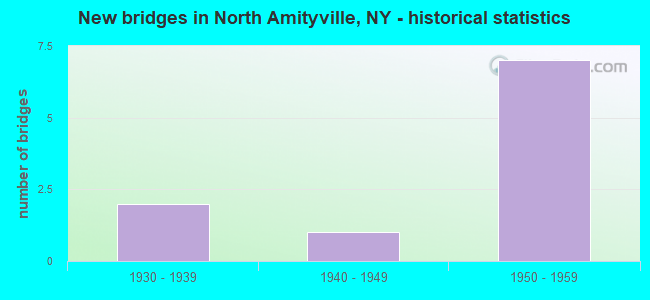
- New bridges - historical statistics
- 21930-1939
- 11940-1949
- 71950-1959

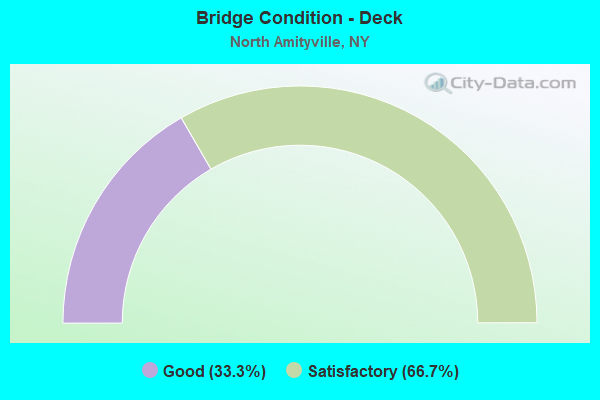
- Bridge Condition - Deck
- 33.3%Good
- 66.7%Satisfactory
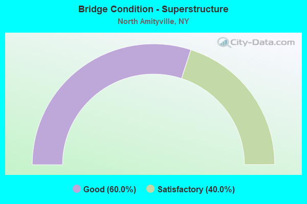
- Bridge Condition - Superstructure
- 60.0%Good
- 40.0%Satisfactory
Find on map >> Show street view
Structure Number: 1036949, Location: JCT SH 110 & SSP (Lat: 40.706919, Lng: -73.428128), Route carried "on" structure: State highway 110, Year Built: 1939, Status: Open, Structure Length: 1.98m (6.50ft), Average Daily Traffic: 42,100 (year 2020), Truck Traffic: 4%, Average Future Daily Traffic: 48,574 (year 2040), Design Load: H 20, Features Intersected: RTE 908M
Minimum Vertical Clearance: 30+ m (98+ ft), Kilometerpoint: 4.167, Lanes on structure: 6, Lanes under structure: 4, Base Highway Network: Yes, Owner: State Highway Agency, Approaching Roadway Width: 23.5m (77.1ft), Skew: 20 degrees, Material/Design: Concrete, Design/Construction: Arch - Deck, Number Of Spans In Main Unit: 1, Length of Maximum Span: 18.2m (59.7ft), Curb or Sidewalk Widths: Left: 1.5m (4.9ft), Right: 1.5m (4.9ft), Curb-To-Curb Width: 23.3m (76.4ft), Out-to-Out Width: 28.0m (91.9ft)
Condition: Superstructure: Good, Substructure: Good, Operating Rating: 89.8 metric tons, Method Used To Determine Operating Rating: Load Factor (LF), Inventory Rating: 81.6 metric tons, Method Used To Determine Inventory Rating: Load Factor (LF), Structural Evaluation: Better than present minimum criteria, Deck Geometry: Meets minimum limits, Underclear: High priority of corrective action, Approach Roadway Alignment: Equal to present desirable criteria, Length Of Structure Improvement: 1.98m (6.50ft), Designated Inspection Frequency: Every 24 months, Inspection Date: September 2020, Bridge Improvement Cost: $3,972,000, Roadway Improvement Cost: $2,326,000, Total Project Cost: $6,298,000 ( Estimate for 2021), Wearing Surface/Protective System: Wearing Surface: Integral Concrete
Find on map >> Show street view
Structure Number: 105709, Location: .2 MI E JCT SH 110 & SSP (Lat: 40.707589, Lng: -73.423953), Route carried "on" structure: County highway , Year Built: 1940, Status: Open, Structure Length: 2.77m (9.09ft), Average Daily Traffic: 14,699 (year 2018), Truck Traffic: 4%, Average Future Daily Traffic: 17,856 (year 2040), Design Load: H 20, Features Intersected: SSP CLOSED GAS STA, SPAN, Facility Carried by Structure: GREAT NECK ROAD
Minimum Vertical Clearance: 30+ m (98+ ft), Kilometerpoint: 5.213, Lanes on structure: 2, Owner: State Highway Agency, Approaching Roadway Width: 12.2m (40.0ft), Skew: 24 degrees, Material/Design: Concrete continuous, Design/Construction: Frame, Number Of Spans In Main Unit: 2, Length of Maximum Span: 12.8m (42.0ft), Curb or Sidewalk Widths: Left: 1.5m (4.9ft), Right: 1.5m (4.9ft), Curb-To-Curb Width: 12.2m (40.0ft), Out-to-Out Width: 16.2m (53.1ft)
Condition: Deck: Satisfactory, Superstructure: Good, Substructure: Good, Operating Rating: 59.1 metric tons, Method Used To Determine Operating Rating: Field evaluation and documented engineering judgment, Inventory Rating: 24.6 metric tons, Method Used To Determine Inventory Rating: Field evaluation and documented engineering judgment, Structural Evaluation: Equal to present minimum criteria, Deck Geometry: Somewhat better than minimum adequacy, Approach Roadway Alignment: Equal to present desirable criteria, Length Of Structure Improvement: 2.77m (9.09ft), Designated Inspection Frequency: Every 24 months, Inspection Date: October 2020, Bridge Improvement Cost: $2,597,000, Roadway Improvement Cost: $1,521,000, Total Project Cost: $4,118,000 ( Estimate for 2021), Wearing Surface/Protective System: Wearing Surface: Bituminous
Find on map >> Show street view
Structure Number: 105774, Location: .2 MI E JCT SH 110 & SSP (Lat: 40.707864, Lng: -73.424361), Route carried "on" structure: County highway , Year Built: 1959, Status: Open, Structure Length: 3.63m (11.91ft), Average Daily Traffic: 14,699 (year 2018), Truck Traffic: 4%, Average Future Daily Traffic: 17,856 (year 2040), Design Load: H 20, Features Intersected: RTE 908M, CLOSED SERVICE, Facility Carried by Structure: GREAT NECK ROAD
Minimum Vertical Clearance: 30+ m (98+ ft), Kilometerpoint: 5.245, Lanes on structure: 2, Lanes under structure: 4, Owner: State Highway Agency, Approaching Roadway Width: 12.2m (40.0ft), Skew: 24 degrees, Material/Design: Concrete, Design/Construction: Frame, Number Of Spans In Main Unit: 1, Number Of Approach Spans: 1, Length of Maximum Span: 24.3m (79.7ft), Curb or Sidewalk Widths: Left: 1.5m (4.9ft), Right: 1.5m (4.9ft), Curb-To-Curb Width: 12.2m (40.0ft), Out-to-Out Width: 16.2m (53.1ft)
Condition: Deck: Good, Superstructure: Good, Substructure: Good, Operating Rating: 57.1 metric tons, Method Used To Determine Operating Rating: Field evaluation and documented engineering judgment, Inventory Rating: 24.4 metric tons, Method Used To Determine Inventory Rating: Field evaluation and documented engineering judgment, Structural Evaluation: Equal to present minimum criteria, Deck Geometry: Somewhat better than minimum adequacy, Underclear: High priority of corrective action, Approach Roadway Alignment: Equal to present desirable criteria, Length Of Structure Improvement: 3.62m (11.88ft), Designated Inspection Frequency: Every 24 months, Inspection Date: October 2020, Bridge Improvement Cost: $2,894,000, Roadway Improvement Cost: $1,695,000, Total Project Cost: $4,588,000 ( Estimate for 2021), Wearing Surface/Protective System: Wearing Surface: Bituminous
Find on map >> Show street view
Structure Number: 1057949, Location: JCT SH 110 & SSP (Lat: 40.707167, Lng: -73.428064), Route carried "on" structure: State highway 110, Year Built: 1957, Status: Open, Structure Length: 2.26m (7.41ft), Average Daily Traffic: 42,100 (year 2020), Truck Traffic: 4%, Average Future Daily Traffic: 48,574 (year 2040), Features Intersected: RTE 908M
Minimum Vertical Clearance: 30+ m (98+ ft), Kilometerpoint: 4.167, Lanes on structure: 6, Lanes under structure: 4, Base Highway Network: Yes, Owner: State Highway Agency, Approaching Roadway Width: 23.3m (76.4ft), Skew: 20 degrees, Material/Design: Concrete, Design/Construction: Arch - Deck, Number Of Spans In Main Unit: 1, Length of Maximum Span: 21.0m (68.9ft), Curb or Sidewalk Widths: Left: 1.5m (4.9ft), Right: 1.5m (4.9ft), Curb-To-Curb Width: 23.3m (76.4ft), Out-to-Out Width: 28.0m (91.9ft)
Condition: Superstructure: Satisfactory, Substructure: Good, Operating Rating: 89.8 metric tons, Method Used To Determine Operating Rating: Load Factor (LF), Inventory Rating: 66.2 metric tons, Method Used To Determine Inventory Rating: Load Factor (LF), Structural Evaluation: Equal to present minimum criteria, Deck Geometry: Meets minimum limits, Underclear: High priority of corrective action, Approach Roadway Alignment: Equal to present desirable criteria, Length Of Structure Improvement: 2.25m (7.38ft), Designated Inspection Frequency: Every 24 months, Inspection Date: September 2020, Bridge Improvement Cost: $4,836,000, Roadway Improvement Cost: $2,832,000, Total Project Cost: $7,668,000 ( Estimate for 2021), Wearing Surface/Protective System: Wearing Surface: Integral Concrete
Find on map >> Show street view
Structure Number: 105974, Location: .2 MI E JCT SH 110 & SSP (Lat: 40.707450, Lng: -73.423706), Route carried "on" structure: County highway , Year Built: 1959, Status: Open, Structure Length: 2.56m (8.40ft), Average Daily Traffic: 14,699 (year 2018), Truck Traffic: 4%, Average Future Daily Traffic: 17,856 (year 2040), Design Load: H 20, Features Intersected: RTE 908M, Facility Carried by Structure: GREAT NECK ROAD
Minimum Vertical Clearance: 30+ m (98+ ft), Kilometerpoint: 5.181, Lanes on structure: 3, Lanes under structure: 4, Owner: State Highway Agency, Approaching Roadway Width: 12.2m (40.0ft), Skew: 24 degrees, Material/Design: Concrete, Design/Construction: Frame, Number Of Spans In Main Unit: 1, Length of Maximum Span: 24.3m (79.7ft), Curb or Sidewalk Widths: Left: 1.5m (4.9ft), Right: 1.5m (4.9ft), Curb-To-Curb Width: 12.2m (40.0ft), Out-to-Out Width: 16.2m (53.1ft)
Condition: Deck: Satisfactory, Superstructure: Satisfactory, Substructure: Good, Operating Rating: 64.2 metric tons, Method Used To Determine Operating Rating: Field evaluation and documented engineering judgment, Inventory Rating: 24.4 metric tons, Method Used To Determine Inventory Rating: Field evaluation and documented engineering judgment, Structural Evaluation: Equal to present minimum criteria, Deck Geometry: Meets minimum limits, Underclear: High priority of corrective action, Approach Roadway Alignment: Equal to present desirable criteria, Length Of Structure Improvement: 2.56m (8.40ft), Designated Inspection Frequency: Every 24 months, Inspection Date: October 2020, Bridge Improvement Cost: $2,479,000, Roadway Improvement Cost: $1,452,000, Total Project Cost: $3,930,000 ( Estimate for 2021), Wearing Surface/Protective System: Wearing Surface: Bituminous
Find on map >> Show street view
Structure Number: 1036949, Location: JCT SH 110 & SSP (Lat: 40.706919, Lng: -73.428128), Route carried "under" structure: State highway 908M, Year Built: 1939, Structure Length: 0. m, Average Daily Traffic: 143,402 (year 2002), Features Intersected: RTE 908M, Facility Carried by Structure: RTE 110
Minimum Vertical Clearance: 4.01m (13.16ft), Kilometerpoint: 0.209, Lanes on structure: 6, Lanes under structure: 4, Material/Design: Concrete, Design/Construction: Arch - Deck, Length of Maximum Span: 18.2m (59.7ft)
Find on map >> Show street view
Structure Number: 105774, Location: .2 MI E JCT SH 110 & SSP (Lat: 40.707864, Lng: -73.424361), Route carried "under" structure: State highway 908M, Year Built: 1959, Structure Length: 0. m, Features Intersected: RTE 908M, CLOSED SERVICE, Facility Carried by Structure: GREAT NECK ROAD
Minimum Vertical Clearance: 4.06m (13.32ft), Kilometerpoint: 0.611, Lanes on structure: 2, Lanes under structure: 4, Material/Design: Concrete, Design/Construction: Frame, Length of Maximum Span: 24.3m (79.7ft)
Find on map >> Show street view
Structure Number: 1057949, Location: JCT SH 110 & SSP (Lat: 40.707167, Lng: -73.428064), Route carried "under" structure: State highway 908M, Year Built: 1957, Structure Length: 0. m, Average Daily Traffic: 143,402 (year 2002), Features Intersected: RTE 908M, Facility Carried by Structure: RTE 110
Minimum Vertical Clearance: 4.06m (13.32ft), Kilometerpoint: 0.209, Lanes on structure: 6, Lanes under structure: 4, Material/Design: Concrete, Design/Construction: Arch - Deck, Length of Maximum Span: 21.0m (68.9ft)
Find on map >> Show street view
Structure Number: 105974, Location: .2 MI E JCT SH 110 & SSP (Lat: 40.707450, Lng: -73.423706), Route carried "under" structure: State highway 908M, Year Built: 1959, Structure Length: 0. m, Average Daily Traffic: 143,402 (year 2002), Features Intersected: RTE 908M, Facility Carried by Structure: GREAT NECK ROAD
Minimum Vertical Clearance: 4.24m (13.91ft), Kilometerpoint: 0.611, Lanes on structure: 3, Lanes under structure: 4, Material/Design: Concrete, Design/Construction: Frame, Length of Maximum Span: 24.3m (79.7ft)
Find on map >> Show street view
Structure Number: 705721, Location: .9 MI E JCT RTS 110+109 (Lat: 40.717108, Lng: -73.408006), Route carried "under" structure: Ramp Other road , Year Built: 1959, Structure Length: 0. m, Average Daily Traffic: 31,000 (year 1977), Features Intersected: SSP EB TO 109 SB, Facility Carried by Structure: LIRR BABYLON
Minimum Vertical Clearance: 3.86m (12.66ft), Kilometerpoint: 0.000, Lanes under structure: 2, Material/Design: Steel, Design/Construction: Girder and Floorbeam System, Length of Maximum Span: 16.7m (54.8ft)