Bridge Statistics for North Atlanta, Georgia (GA)
Condition, Traffic, Stress, Structural Evaluation, Project Costs
- National Bridge Inventory (NBI) Statistics
- 20Number of bridges
- 154ft / 46.9mTotal length
- $18,761,000Total costs
- 634,414Total average daily traffic
- 7,375Total average daily truck traffic
- National Bridge Inventory (NBI) Registered Bridges for North Atlanta
- No street view available for this location
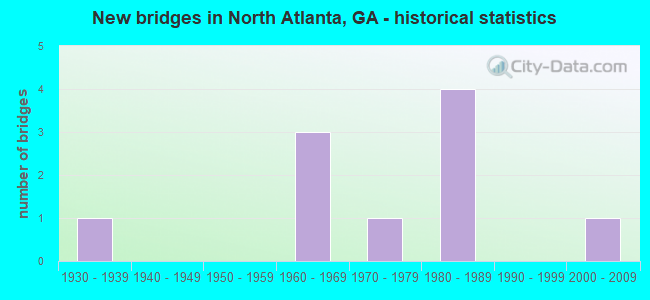
- New bridges - historical statistics
- 11930-1939
- 31960-1969
- 11970-1979
- 41980-1989
- 12000-2009


- Bridge Condition - Deck
- 77.8%Good
- 22.2%Satisfactory

- Bridge Condition - Superstructure
- 11.1%Very good
- 88.9%Good

- Bridge Condition - Substructure
- 11.1%Very good
- 77.8%Good
- 11.1%Satisfactory

- Bridge Condition - Channel
- 14.3%Excellent
- 28.6%Very good
- 42.9%Good
- 14.3%Poor
Find on map >> Show street view
Structure Number: 89002, Location: 5.1 MI NW OF DECATUR (Lat: 33.831408, Lng: -84.342697), Route carried "on" structure: State highway 13, Year Built: 1974, Status: Open, Structure Length: 5.03m (16.50ft), Average Daily Traffic: 34,590 (year 2011), Truck Traffic: 4%, Average Future Daily Traffic: 51,885 (year 2031), Design Load: HS 20+Mod, Features Intersected: N FORK PEACHTREE CREEK, Facility Carried by Structure: BUFORD HIGHWAY
Minimum Vertical Clearance: 30+ m (98+ ft), Kilometerpoint: 0.000, Lanes on structure: 7, Base Highway Network: Yes, Owner: State Highway Agency, Approaching Roadway Width: 24.4m (80.1ft), Material/Design: Steel, Design/Construction: Stringer/Multi-beam, Number Of Spans In Main Unit: 3, Length of Maximum Span: 21.9m (71.9ft), Curb or Sidewalk Widths: Left: 1.2m (3.9ft), Right: 1.2m (3.9ft), Curb-To-Curb Width: 24.4m (80.1ft), Out-to-Out Width: 27.6m (90.6ft)
Condition: Deck: Good, Superstructure: Good, Substructure: Good, Channel: Good, Operating Rating: 46.2 metric tons, Method Used To Determine Operating Rating: Allowable Stress (AS), Inventory Rating: 32.6 metric tons, Method Used To Determine Inventory Rating: Allowable Stress (AS), Structural Evaluation: Better than present minimum criteria, Deck Geometry: High priority of replacement, Waterway Adequacy: Equal to present desirable criteria, Approach Roadway Alignment: Equal to present desirable criteria, Designated Inspection Frequency: Every 24 months, Inspection Date: June 2020, Bridge Improvement Cost: $1,524,000, Roadway Improvement Cost: $152,000, Total Project Cost: $2,286,000, Deck Structure Type: Concrete Cast-file-Place
Find on map >> Show street view
Structure Number: 890021, Location: 5.6 MI N OF DECATUR (Lat: 33.849531, Lng: -84.321403), Route carried "on" structure: State highway 13, Year Built: 1935, Year Reconstructed: 1971, Status: Open, Structure Length: 0.70m (2.30ft), Average Daily Traffic: 25,600 (year 2011), Truck Traffic: 1%, Average Future Daily Traffic: 38,400 (year 2031), Design Load: H 15, Features Intersected: N FORK P'TREE CREEK TRIB, Facility Carried by Structure: BUFORD HIGHWAY
Minimum Vertical Clearance: 30+ m (98+ ft), Kilometerpoint: 3.219, Lanes on structure: 7, Base Highway Network: Yes, Owner: State Highway Agency, Approaching Roadway Width: 23.8m (78.1ft), Skew: 9 degrees, Material/Design: Concrete, Design/Construction: Culvert, Number Of Spans In Main Unit: 2, Length of Maximum Span: 3.0m (9.8ft)
Condition: Channel: Very good, Culverts: Satisfactory, Operating Rating: 41.7 metric tons, Method Used To Determine Operating Rating: Field evaluation and documented engineering judgment, Inventory Rating: 24.4 metric tons, Method Used To Determine Inventory Rating: Field evaluation and documented engineering judgment, Structural Evaluation: Equal to present minimum criteria, Waterway Adequacy: Equal to present minimum criteria, Approach Roadway Alignment: Equal to present desirable criteria, Designated Inspection Frequency: Every 24 months, Inspection Date: June 2020, Bridge Improvement Cost: $212,000, Roadway Improvement Cost: $21,000, Total Project Cost: $319,000
Find on map >> Show street view
Structure Number: 89003, Location: 4.8 MI N OF DECATUR (Lat: 33.832097, Lng: -84.335319), Route carried "on" structure: State highway 42, Year Built: 1981, Status: Open, Structure Length: 10.97m (35.99ft), Average Daily Traffic: 50,570 (year 2011), Truck Traffic: 1%, Average Future Daily Traffic: 75,855 (year 2031), Design Load: HS 20+Mod, Features Intersected: I-85- I-85 RAMP, Facility Carried by Structure: N. DRUID HILLS RD.
Minimum Vertical Clearance: 30+ m (98+ ft), Kilometerpoint: 22.531, Lanes on structure: 8, Lanes under structure: 13, Base Highway Network: Yes, Owner: State Highway Agency, Approaching Roadway Width: 31.7m (104.0ft), Skew: 23 degrees, Material/Design: Steel, Design/Construction: Stringer/Multi-beam, Number Of Spans In Main Unit: 4, Length of Maximum Span: 33.8m (110.9ft), Curb or Sidewalk Widths: Left: 2.1m (6.9ft), Right: 2.1m (6.9ft), Curb-To-Curb Width: 31.7m (104.0ft), Out-to-Out Width: 36.7m (120.4ft)
Condition: Deck: Good, Superstructure: Good, Substructure: Good, Operating Rating: 45.3 metric tons, Method Used To Determine Operating Rating: Load Factor (LF), Inventory Rating: 27.2 metric tons, Method Used To Determine Inventory Rating: Load Factor (LF), Structural Evaluation: Equal to present minimum criteria, Deck Geometry: Somewhat better than minimum adequacy, Underclear: High priority of corrective action, Approach Roadway Alignment: Equal to present desirable criteria, Designated Inspection Frequency: Every 24 months, Inspection Date: June 2020, Bridge Improvement Cost: $3,708,000, Roadway Improvement Cost: $371,000, Total Project Cost: $5,562,000, Deck Structure Type: Concrete Cast-file-Place
Find on map >> Show street view
Structure Number: 890031, Location: 5 MI NW OF DECATUR (Lat: 33.833219, Lng: -84.338839), Route carried "on" structure: State highway 42, Year Built: 1962, Status: Open, Structure Length: 5.79m (19.00ft), Average Daily Traffic: 50,570 (year 2011), Truck Traffic: 1%, Average Future Daily Traffic: 75,855 (year 2031), Design Load: HS 20+Mod, Features Intersected: N FORK PEACHTREE CREEK, Facility Carried by Structure: N. DRUID HILLS RD.
Minimum Vertical Clearance: 30+ m (98+ ft), Kilometerpoint: 22.531, Lanes on structure: 6, Base Highway Network: Yes, Owner: State Highway Agency, Approaching Roadway Width: 21.3m (69.9ft), Skew: 21 degrees, Material/Design: Steel continuous, Design/Construction: Stringer/Multi-beam, Number Of Spans In Main Unit: 3, Length of Maximum Span: 22.6m (74.1ft), Curb or Sidewalk Widths: Left: 1.6m (5.2ft), Right: 1.6m (5.2ft), Curb-To-Curb Width: 21.9m (71.9ft), Out-to-Out Width: 25.8m (84.6ft)
Condition: Deck: Satisfactory, Superstructure: Good, Substructure: Satisfactory, Channel: Poor, Operating Rating: 34.4 metric tons, Method Used To Determine Operating Rating: Load Factor (LF), Inventory Rating: 20.8 metric tons, Method Used To Determine Inventory Rating: Load Factor (LF), Structural Evaluation: Somewhat better than minimum adequacy, Deck Geometry: High priority of corrective action, Waterway Adequacy: Equal to present desirable criteria, Approach Roadway Alignment: Equal to present desirable criteria, Designated Inspection Frequency: Every 24 months, Inspection Date: June 2020, Bridge Improvement Cost: $1,552,000, Roadway Improvement Cost: $155,000, Total Project Cost: $2,328,000, Deck Structure Type: Concrete Cast-file-Place
Find on map >> Show street view
Structure Number: 890063, Location: 4.2 MI SW OF CHAMBLEE (Lat: 33.835756, Lng: -84.327336), Route carried "on" structure: Interstate 85, Year Built: 1981, Status: Open, Structure Length: 5.88m (19.29ft), Average Daily Traffic: 200,230 (year 2011), Truck Traffic: 1%, Average Future Daily Traffic: 300,345 (year 2031), Design Load: HS 20+Mod, Features Intersected: M-9217 ACCESS RD TURN
Minimum Vertical Clearance: 30+ m (98+ ft), Kilometerpoint: 144.841, Lanes on structure: 12, Lanes under structure: 2, Base Highway Network: Yes, Owner: State Highway Agency, Approaching Roadway Width: 50.6m (166.0ft), Skew: 30 degrees, Material/Design: Prestressed concrete, Design/Construction: Stringer/Multi-beam, Number Of Spans In Main Unit: 2, Length of Maximum Span: 29.6m (97.1ft), Curb-To-Curb Width: 51.2m (168.0ft), Out-to-Out Width: 52.1m (170.9ft)
Condition: Deck: Good, Superstructure: Good, Substructure: Good, Operating Rating: 48.0 metric tons, Method Used To Determine Operating Rating: Load Factor (LF), Inventory Rating: 29.0 metric tons, Method Used To Determine Inventory Rating: Load Factor (LF), Structural Evaluation: Better than present minimum criteria, Deck Geometry: Better than present minimum criteria, Underclear: Superior to present desirable criteria, Approach Roadway Alignment: Equal to present desirable criteria, Designated Inspection Frequency: Every 24 months, Inspection Date: June 2020, Bridge Improvement Cost: $2,811,000, Roadway Improvement Cost: $281,000, Total Project Cost: $4,216,000, Deck Structure Type: Concrete Cast-file-Place, Wearing Surface/Protective System: Deck Protection: Epoxy Coated Reinforcing
Find on map >> Show street view
Structure Number: 895053, Location: IN BROOKHAVEN (Lat: 33.856178, Lng: -84.343108), Route carried "on" structure: County highway 1673, Year Built: 1980, Status: Open, Structure Length: 4.75m (15.58ft), Average Daily Traffic: 2,202 (year 2011), Truck Traffic: 1%, Average Future Daily Traffic: 3,303 (year 2031), Design Load: HS 20+Mod, Features Intersected: MARTA-NS RAILROAD, Facility Carried by Structure: COLONIAL DRIVE
Minimum Vertical Clearance: 30+ m (98+ ft), Kilometerpoint: 1.609, Lanes on structure: 2, Base Highway Network: Yes, Owner: County Highway Agency, Approaching Roadway Width: 7.9m (25.9ft), Material/Design: Prestressed concrete, Design/Construction: Box Beam or Girders - Multiple, Number Of Spans In Main Unit: 4, Length of Maximum Span: 12.2m (40.0ft), Curb or Sidewalk Widths: Left: 1.5m (4.9ft), Right: 1.5m (4.9ft), Curb-To-Curb Width: 7.4m (24.3ft), Out-to-Out Width: 11.1m (36.4ft)
Condition: Deck: Good, Superstructure: Good, Substructure: Good, Operating Rating: 40.8 metric tons, Method Used To Determine Operating Rating: Load Factor (LF), Inventory Rating: 24.4 metric tons, Method Used To Determine Inventory Rating: Load Factor (LF), Structural Evaluation: Equal to present minimum criteria, Deck Geometry: High priority of replacement, Underclear: Meets minimum limits, Approach Roadway Alignment: Meets minimum limits, Length Of Structure Improvement: 44.99m (147.60ft), Designated Inspection Frequency: Every 24 months, Inspection Date: September 2020, Bridge Improvement Cost: $610,000, Roadway Improvement Cost: $61,000, Total Project Cost: $914,000, Deck Structure Type: Concrete Precast Panels, Wearing Surface/Protective System: Wearing Surface: Bituminous
Find on map >> Show street view
Structure Number: 895054, Location: 0.5 MI S OF BROOKHAVEN (Lat: 33.852719, Lng: -84.344208), Route carried "on" structure: County highway 1675, Year Built: 1984, Status: Open, Structure Length: 0.88m (2.89ft), Average Daily Traffic: 2,202 (year 2011), Truck Traffic: 1%, Average Future Daily Traffic: 3,303 (year 2031), Design Load: HS 15, Features Intersected: N FORK P'TREE CREEK TRIB, Facility Carried by Structure: PINE GROVE AVE.
Minimum Vertical Clearance: 30+ m (98+ ft), Kilometerpoint: 0.000, Lanes on structure: 2, Base Highway Network: Yes, Owner: County Highway Agency, Approaching Roadway Width: 7.3m (24.0ft), Material/Design: Prestressed concrete, Design/Construction: Box Beam or Girders - Multiple, Number Of Spans In Main Unit: 1, Length of Maximum Span: 8.8m (28.9ft), Curb or Sidewalk Widths: Left: 1.1m (3.6ft), Right: 1.5m (4.9ft), Curb-To-Curb Width: 7.7m (25.3ft), Out-to-Out Width: 11.0m (36.1ft)
Condition: Deck: Good, Superstructure: Good, Substructure: Good, Channel: Very good, Operating Rating: 55.3 metric tons, Method Used To Determine Operating Rating: Load Factor (LF), Inventory Rating: 33.5 metric tons, Method Used To Determine Inventory Rating: Load Factor (LF), Structural Evaluation: Better than present minimum criteria, Deck Geometry: High priority of replacement, Waterway Adequacy: Better than present minimum criteria, Approach Roadway Alignment: Better than present minimum criteria, Designated Inspection Frequency: Every 24 months, Inspection Date: June 2020, Bridge Improvement Cost: $113,000, Roadway Improvement Cost: $11,000, Total Project Cost: $170,000, Deck Structure Type: Concrete Precast Panels, Wearing Surface/Protective System: Wearing Surface: Bituminous
Find on map >> Show street view
Structure Number: 89506, Location: 3.3 MI W OF CHAMBLEE (Lat: 33.893281, Lng: -84.347231), Route carried "on" structure: County highway 1887, Year Built: 1965, Status: Open, Structure Length: 4.02m (13.19ft), Average Daily Traffic: 2,202 (year 2011), Truck Traffic: 1%, Average Future Daily Traffic: 3,303 (year 2031), Design Load: H 15, Features Intersected: NANCY CREEK, Facility Carried by Structure: MILL CREEK ROAD
Minimum Vertical Clearance: 30+ m (98+ ft), Kilometerpoint: 0.000, Lanes on structure: 2, Base Highway Network: Yes, Owner: County Highway Agency, Approaching Roadway Width: 9.1m (29.9ft), Skew: 3 degrees, Material/Design: Concrete, Design/Construction: Tee Beam, Number Of Spans In Main Unit: 4, Length of Maximum Span: 10.1m (33.1ft), Curb or Sidewalk Widths: Left: 0.7m (2.3ft), Right: 0.7m (2.3ft), Curb-To-Curb Width: 8.5m (27.9ft), Out-to-Out Width: 10.4m (34.1ft)
Condition: Deck: Satisfactory, Superstructure: Good, Substructure: Good, Channel: Good, Operating Rating: 39.0 metric tons, Method Used To Determine Operating Rating: Load Factor (LF), Inventory Rating: 23.5 metric tons, Method Used To Determine Inventory Rating: Load Factor (LF), Structural Evaluation: Equal to present minimum criteria, Deck Geometry: Meets minimum limits, Waterway Adequacy: Better than present minimum criteria, Approach Roadway Alignment: Equal to present minimum criteria, Designated Inspection Frequency: Every 24 months, Inspection Date: July 2020, Bridge Improvement Cost: $516,000, Roadway Improvement Cost: $52,000, Total Project Cost: $774,000, Deck Structure Type: Concrete Cast-file-Place
Find on map >> Show street view
Structure Number: 89507, Location: 5 MI NW OF CLARKSTON (Lat: 33.835644, Lng: -84.335911), Route carried "on" structure: County highway 3105, Year Built: 1967, Status: Open, Structure Length: 4.63m (15.19ft), Average Daily Traffic: 2,202 (year 2011), Truck Traffic: 1%, Average Future Daily Traffic: 3,303 (year 2031), Features Intersected: N FORK PEACHTREE CREEK, Facility Carried by Structure: CORPORATE BLVD.
Minimum Vertical Clearance: 30+ m (98+ ft), Kilometerpoint: 0.000, Lanes on structure: 4, Base Highway Network: Yes, Owner: County Highway Agency, Approaching Roadway Width: 14.6m (47.9ft), Material/Design: Steel, Design/Construction: Stringer/Multi-beam, Number Of Spans In Main Unit: 3, Length of Maximum Span: 15.5m (50.9ft), Curb or Sidewalk Widths: Left: 1.4m (4.6ft), Right: 1.4m (4.6ft), Curb-To-Curb Width: 14.6m (47.9ft), Out-to-Out Width: 18.3m (60.0ft)
Condition: Deck: Good, Superstructure: Good, Substructure: Good, Channel: Good, Operating Rating: 50.8 metric tons, Method Used To Determine Operating Rating: Load Factor (LF), Inventory Rating: 29.9 metric tons, Method Used To Determine Inventory Rating: Load Factor (LF), Structural Evaluation: Better than present minimum criteria, Deck Geometry: High priority of replacement, Waterway Adequacy: Equal to present desirable criteria, Approach Roadway Alignment: Better than present minimum criteria, Designated Inspection Frequency: Every 24 months, Inspection Date: June 2020, Bridge Improvement Cost: $918,000, Roadway Improvement Cost: $92,000, Total Project Cost: $1,377,000, Deck Structure Type: Concrete Cast-file-Place
Find on map >> Show street view
Structure Number: 895147, Location: 5 MI S OF CHAMBLEE (Lat: 33.841794, Lng: -84.321950), Route carried "on" structure: County highway 1644, Year Built: 2005, Status: Open, Structure Length: 4.24m (13.91ft), Average Daily Traffic: 2,202 (year 2011), Truck Traffic: 1%, Average Future Daily Traffic: 3,303 (year 2031), Design Load: HS 20+Mod, Features Intersected: N FORK PEACHTREE CREEK, Facility Carried by Structure: BRIARWOOD ROAD
Minimum Vertical Clearance: 30+ m (98+ ft), Kilometerpoint: 0.000, Lanes on structure: 2, Base Highway Network: Yes, Owner: County Highway Agency, Approaching Roadway Width: 11.0m (36.1ft), Material/Design: Prestressed concrete, Design/Construction: Stringer/Multi-beam, Number Of Spans In Main Unit: 1, Length of Maximum Span: 42.4m (139.1ft), Curb or Sidewalk Widths: Left: 1.8m (5.9ft), Right: 1.8m (5.9ft), Curb-To-Curb Width: 11.1m (36.4ft), Out-to-Out Width: 15.5m (50.9ft)
Condition: Deck: Good, Superstructure: Very good, Substructure: Very good, Channel: Excellent, Operating Rating: 89.8 metric tons, Method Used To Determine Operating Rating: Load Factor (LF), Inventory Rating: 25.4 metric tons, Method Used To Determine Inventory Rating: Load Factor (LF), Structural Evaluation: Equal to present minimum criteria, Deck Geometry: Somewhat better than minimum adequacy, Waterway Adequacy: Equal to present desirable criteria, Approach Roadway Alignment: Equal to present minimum criteria, Designated Inspection Frequency: Every 24 months, Inspection Date: May 2020, Bridge Improvement Cost: $543,000, Roadway Improvement Cost: $54,000, Total Project Cost: $815,000, Deck Structure Type: Concrete Cast-file-Place
Find on map >> Show street view
Structure Number: 89003, Location: 4.8 MI N OF DECATUR (Lat: 33.832097, Lng: -84.335319), Route carried "under" structure: Interstate 85, Structure Length: 0. m, Average Daily Traffic: 197,000 (year 1999), Truck Traffic: 1%, Features Intersected: SR 42 N. DRUID HILLS RD., Facility Carried by Structure: N. DRUID HILLS RD.
Minimum Vertical Clearance: 6.78m (22.24ft), Kilometerpoint: 143.232, Lanes on structure: 8, Length of Maximum Span: 0.0m
Find on map >> Show street view
Structure Number: 89003, Location: 4.8 MI N OF DECATUR (Lat: 33.832097, Lng: -84.335319), Route carried "under" structure: Ramp Interstate 85, Structure Length: 0. m, Average Daily Traffic: 2,750 (year 1996), Truck Traffic: 1%, Features Intersected: SR 42 N. DRUID HILLS RD., Facility Carried by Structure: N. DRUID HILLS RD.
Minimum Vertical Clearance: 6.07m (19.91ft), Kilometerpoint: 143.232, Lanes on structure: 8, Length of Maximum Span: 0.0m
Find on map >> Show street view
Structure Number: 890063, Location: 4.2 MI SW OF CHAMBLEE (Lat: 33.835756, Lng: -84.327336), Route carried "under" structure: City street 9217, Structure Length: 0. m, Average Daily Traffic: 3,200 (year 2009), Truck Traffic: 1%, Features Intersected: I-85, Facility Carried by Structure: I-85
Minimum Vertical Clearance: 5.33m (17.49ft), Kilometerpoint: 1.609, Lanes on structure: 12, Length of Maximum Span: 0.0m
Find on map >> Show street view
Structure Number: 890245, Location: 3.2 MI SW OF CHAMBLEE (Lat: 33.857681, Lng: -84.340397), Route carried "under" structure: City street 9240, Structure Length: 0. m, Average Daily Traffic: 12,370 (year 2011), Truck Traffic: 1%, Features Intersected: M-9240 N. DRUID HILLS RD, Facility Carried by Structure: NORFOLK SOUTHERN R
Minimum Vertical Clearance: 5.00m (16.40ft), Kilometerpoint: 1.609, Length of Maximum Span: 0.0m
Find on map >> Show street view
Structure Number: 890246, Location: 3.3 MI SW OF CHAMBLEE (Lat: 33.860686, Lng: -84.338581), Route carried "under" structure: City street 9266, Structure Length: 0. m, Average Daily Traffic: 8,690 (year 2011), Truck Traffic: 1%, Features Intersected: M-9266 DRESDEN DRIVE, Facility Carried by Structure: NORFOLK SOUTHERN R
Minimum Vertical Clearance: 4.67m (15.32ft), Kilometerpoint: 0.000, Length of Maximum Span: 0.0m
Find on map >> Show street view
Structure Number: 890263, Location: 3.2 MI SW OF CHAMBLEE (Lat: 33.857889, Lng: -84.340508), Route carried "under" structure: City street 9240, Structure Length: 0. m, Average Daily Traffic: 12,370 (year 2011), Truck Traffic: 1%, Features Intersected: M-9240 N. DRUID HILLS RD, Facility Carried by Structure: MARTA TRAINS
Minimum Vertical Clearance: 6.35m (20.83ft), Kilometerpoint: 1.609, Length of Maximum Span: 0.0m
Find on map >> Show street view
Structure Number: 890264, Location: 3.2 MI SW OF CHAMBLEE (Lat: 33.858033, Lng: -84.340517), Route carried "under" structure: City street 9240, Structure Length: 0. m, Average Daily Traffic: 12,370 (year 2011), Truck Traffic: 1%, Features Intersected: M-9240 N. DRUID HILLS RD, Facility Carried by Structure: MARTA TRAINS
Minimum Vertical Clearance: 5.61m (18.41ft), Kilometerpoint: 1.609, Length of Maximum Span: 0.0m
Find on map >> Show street view
Structure Number: 890265, Location: 3 MI SW OF CHAMBLEE (Lat: 33.860706, Lng: -84.339050), Route carried "under" structure: City street 9266, Structure Length: 0. m, Average Daily Traffic: 8,690 (year 2011), Truck Traffic: 1%, Features Intersected: M-9266 DRESDEN DRIVE, Facility Carried by Structure: MARTA BRIDGE
Minimum Vertical Clearance: 5.30m (17.39ft), Kilometerpoint: 0.000, Length of Maximum Span: 0.0m
Find on map >> Show street view
Structure Number: 895103, Location: 0.5 MI SW OF CHAMBLEE (Lat: 33.876378, Lng: -84.325417), Route carried "under" structure: County highway 1940, Structure Length: 0. m, Average Daily Traffic: 2,202 (year 2011), Truck Traffic: 1%, Features Intersected: CR 1940 REDDING ROAD, Facility Carried by Structure: NORFOLK SOUTHERN R
Minimum Vertical Clearance: 5.15m (16.90ft), Kilometerpoint: 1.609, Length of Maximum Span: 0.0m
Find on map >> Show street view
Structure Number: 895104, Location: 0.5 MI SWT OF CHAMBLEE (Lat: 33.876539, Lng: -84.325503), Route carried "under" structure: County highway 1940, Structure Length: 0. m, Average Daily Traffic: 2,202 (year 2011), Truck Traffic: 1%, Features Intersected: CR 1940 REDDING ROAD, Facility Carried by Structure: MARTA BRIDGE
Minimum Vertical Clearance: 6.47m (21.23ft), Kilometerpoint: 1.609, Length of Maximum Span: 0.0m