Bridge Statistics for North Bay Shore, New York (NY)
Condition, Traffic, Stress, Structural Evaluation, Project Costs
- National Bridge Inventory (NBI) Statistics
- 14Number of bridges
- 72ft / 21.9mTotal length
- $37,631,000Total costs
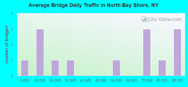
- 688,690Total average daily traffic
- 4,336Total average daily truck traffic
- National Bridge Inventory (NBI) Registered Bridges for North Bay Shore
- No street view available for this location

- New bridges - historical statistics
- 21950-1959
- 121960-1969
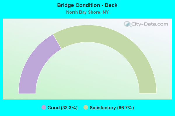
- Bridge Condition - Deck
- 33.3%Good
- 66.7%Satisfactory
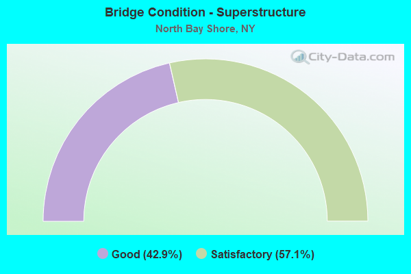
- Bridge Condition - Superstructure
- 42.9%Good
- 57.1%Satisfactory
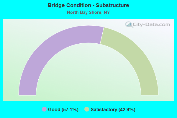
- Bridge Condition - Substructure
- 57.1%Good
- 42.9%Satisfactory
Find on map >> Show street view
Structure Number: 105891, Location: 2.7 MI NE JCT SH 231 & SS (Lat: 40.745553, Lng: -73.278950), Route carried "on" structure: State highway 908M, Year Built: 1961, Status: Open, Structure Length: 2.07m (6.79ft), Average Daily Traffic: 79,255 (year 2018), Truck Traffic: 1%, Average Future Daily Traffic: 94,273 (year 2040), Design Load: HS 20, Features Intersected: RTE 908K
Minimum Vertical Clearance: 30+ m (98+ ft), Kilometerpoint: 14.288, Lanes on structure: 3, Lanes under structure: 2, Base Highway Network: Yes, Owner: State Highway Agency, Approaching Roadway Width: 16.2m (53.1ft), Skew: 5 degrees, Material/Design: Steel, Design/Construction: Stringer/Multi-beam, Number Of Spans In Main Unit: 1, Length of Maximum Span: 18.2m (59.7ft), Curb-To-Curb Width: 16.2m (53.1ft), Out-to-Out Width: 17.4m (57.1ft)
Condition: Deck: Satisfactory, Superstructure: Satisfactory, Substructure: Satisfactory, Operating Rating: 64.8 metric tons, Method Used To Determine Operating Rating: Load and Resistance Factor Rating (LRFR) rating reported by rating factor(RF) method using HL-93 loadings, Inventory Rating: 49.9 metric tons, Method Used To Determine Inventory Rating: Load and Resistance Factor Rating (LRFR) rating reported by rating factor(RF) method using HL-93 loadings, Structural Evaluation: Equal to present minimum criteria, Deck Geometry: Equal to present minimum criteria, Underclear: High priority of corrective action, Approach Roadway Alignment: Equal to present desirable criteria, Length Of Structure Improvement: 2.07m (6.79ft), Designated Inspection Frequency: Every 24 months, Inspection Date: August 2020, Bridge Improvement Cost: $2,969,000, Roadway Improvement Cost: $1,739,000, Total Project Cost: $4,708,000 ( Estimate for 2021), Deck Structure Type: Concrete Cast-file-Place, Wearing Surface/Protective System: Wearing Surface: Bituminous, Membrane: Preformed Fabric
Find on map >> Show street view
Structure Number: 105892, Location: 2.7 MI NE JCT SH 231 & SS (Lat: 40.747108, Lng: -73.278997), Route carried "on" structure: Ramp Other road , Year Built: 1961, Status: Open, Structure Length: 2.23m (7.32ft), Average Daily Traffic: 13,604 (year 2018), Truck Traffic: 2%, Average Future Daily Traffic: 16,181 (year 2040), Design Load: HS 20, Features Intersected: RTE 908K, Facility Carried by Structure: SGSP SB TO SSP EB
Minimum Vertical Clearance: 30+ m (98+ ft), Kilometerpoint: 0.274, Lanes on structure: 1, Lanes under structure: 2, Owner: State Highway Agency, Approaching Roadway Width: 10.1m (33.1ft), Skew: 5 degrees, Material/Design: Steel, Design/Construction: Stringer/Multi-beam, Number Of Spans In Main Unit: 1, Length of Maximum Span: 20.1m (65.9ft), Curb-To-Curb Width: 10.1m (33.1ft), Out-to-Out Width: 11.3m (37.1ft)
Condition: Deck: Satisfactory, Superstructure: Satisfactory, Substructure: Satisfactory, Operating Rating: 30.1 metric tons, Method Used To Determine Operating Rating: Load and Resistance Factor Rating (LRFR) rating reported by rating factor(RF) method using HL-93 loadings, Inventory Rating: 23.0 metric tons, Method Used To Determine Inventory Rating: Load and Resistance Factor Rating (LRFR) rating reported by rating factor(RF) method using HL-93 loadings, Structural Evaluation: Somewhat better than minimum adequacy, Deck Geometry: Superior to present desirable criteria, Underclear: High priority of corrective action, Approach Roadway Alignment: Equal to present minimum criteria, Length Of Structure Improvement: 2.22m (7.28ft), Designated Inspection Frequency: Every 24 months, Inspection Date: August 2020, Bridge Improvement Cost: $2,508,000, Roadway Improvement Cost: $1,469,000, Total Project Cost: $3,977,000 ( Estimate for 2021), Deck Structure Type: Concrete Cast-file-Place, Wearing Surface/Protective System: Wearing Surface: Bituminous, Membrane: Preformed Fabric
Find on map >> Show street view
Structure Number: 1058939, Location: 4.9 MI S JCT RTS 454+25 (Lat: 40.771831, Lng: -73.279972), Route carried "on" structure: State highway 908K, Year Built: 1951, Status: Open, Structure Length: 2.19m (7.19ft), Average Daily Traffic: 84,495 (year 2019), Truck Traffic: 1%, Average Future Daily Traffic: 100,506 (year 2040), Features Intersected: PINE AIRE DRIVE
Minimum Vertical Clearance: 30+ m (98+ ft), Kilometerpoint: 3.202, Lanes on structure: 4, Lanes under structure: 4, Base Highway Network: Yes, Owner: State Highway Agency, Approaching Roadway Width: 15.8m (51.8ft), Skew: 21 degrees, Material/Design: Concrete, Design/Construction: Frame, Number Of Spans In Main Unit: 1, Length of Maximum Span: 19.5m (64.0ft), Curb or Sidewalk Widths: Left: 1.7m (5.6ft), Right: 1.7m (5.6ft), Curb-To-Curb Width: 15.8m (51.8ft), Out-to-Out Width: 20.9m (68.6ft)
Condition: Deck: Satisfactory, Superstructure: Satisfactory, Substructure: Good, Operating Rating: 41.7 metric tons, Method Used To Determine Operating Rating: Load Factor (LF), Inventory Rating: 25.4 metric tons, Method Used To Determine Inventory Rating: Load Factor (LF), Structural Evaluation: Equal to present minimum criteria, Deck Geometry: High priority of replacement, Underclear: Meets minimum limits, Approach Roadway Alignment: Equal to present desirable criteria, Length Of Structure Improvement: 2.19m (7.19ft), Designated Inspection Frequency: Every 24 months, Inspection Date: March 2020, Bridge Improvement Cost: $2,877,000, Roadway Improvement Cost: $1,685,000, Total Project Cost: $4,562,000 ( Estimate for 2021), Wearing Surface/Protective System: Wearing Surface: Bituminous, Membrane: Preformed Fabric
Find on map >> Show street view
Structure Number: 105986, Location: 2.7 MI NE JCT SH 231 & SS (Lat: 40.746578, Lng: -73.277275), Route carried "on" structure: Ramp State highway , Year Built: 1961, Status: Open, Structure Length: 3.32m (10.89ft), Average Daily Traffic: 13,604 (year 2018), Truck Traffic: 2%, Average Future Daily Traffic: 16,181 (year 2040), Design Load: HS 20, Features Intersected: RTE 908M, Facility Carried by Structure: SGSP SB TO SSP EB
Minimum Vertical Clearance: 30+ m (98+ ft), Kilometerpoint: 0.434, Lanes on structure: 1, Lanes under structure: 3, Owner: State Highway Agency, Approaching Roadway Width: 10.1m (33.1ft), Skew: 3 degrees, Material/Design: Steel, Design/Construction: Stringer/Multi-beam, Number Of Spans In Main Unit: 1, Length of Maximum Span: 31.0m (101.7ft), Curb-To-Curb Width: 10.1m (33.1ft), Out-to-Out Width: 11.3m (37.1ft)
Condition: Deck: Good, Superstructure: Good, Substructure: Good, Operating Rating: 45.4 metric tons, Method Used To Determine Operating Rating: Load Factor (LF), Inventory Rating: 27.2 metric tons, Method Used To Determine Inventory Rating: Load Factor (LF), Structural Evaluation: Equal to present minimum criteria, Deck Geometry: Superior to present desirable criteria, Underclear: High priority of corrective action, Approach Roadway Alignment: Equal to present minimum criteria, Length Of Structure Improvement: 3.32m (10.89ft), Designated Inspection Frequency: Every 24 months, Inspection Date: November 2020, Bridge Improvement Cost: $2,383,000, Roadway Improvement Cost: $1,396,000, Total Project Cost: $3,779,000 ( Estimate for 2021), Deck Structure Type: Concrete Cast-file-Place, Wearing Surface/Protective System: Wearing Surface: Bituminous, Membrane: Preformed Fabric
Find on map >> Show street view
Structure Number: 1059879, Location: 3.0 MI NE JCT RTS 231+SSP (Lat: 40.748928, Lng: -73.269922), Route carried "on" structure: Other road , Year Built: 1961, Status: Open, Structure Length: 3.84m (12.60ft), Average Daily Traffic: 4,087 (year 2017), Truck Traffic: 3%, Average Future Daily Traffic: 5,056 (year 2040), Features Intersected: 908M 908M 0702 1095, WB,, Facility Carried by Structure: MANATUCK ROAD
Minimum Vertical Clearance: 30+ m (98+ ft), Kilometerpoint: 1.850, Lanes on structure: 4, Lanes under structure: 6, Owner: State Highway Agency, Approaching Roadway Width: 14.6m (47.9ft), Skew: 21 degrees, Material/Design: Concrete continuous, Design/Construction: Frame, Number Of Spans In Main Unit: 2, Length of Maximum Span: 17.9m (58.7ft), Curb or Sidewalk Widths: Left: 1.5m (4.9ft), Right: 1.5m (4.9ft), Curb-To-Curb Width: 14.6m (47.9ft), Out-to-Out Width: 19.8m (65.0ft)
Condition: Superstructure: Satisfactory, Substructure: Satisfactory, Operating Rating: 85.4 metric tons, Method Used To Determine Operating Rating: Field evaluation and documented engineering judgment, Inventory Rating: 32.7 metric tons, Method Used To Determine Inventory Rating: Field evaluation and documented engineering judgment, Structural Evaluation: Equal to present minimum criteria, Deck Geometry: High priority of replacement, Underclear: High priority of corrective action, Approach Roadway Alignment: Equal to present desirable criteria, Length Of Structure Improvement: 3.84m (12.60ft), Designated Inspection Frequency: Every 24 months, Inspection Date: July 2021, Bridge Improvement Cost: $3,745,000, Roadway Improvement Cost: $2,193,000, Total Project Cost: $5,938,000 ( Estimate for 2021), Wearing Surface/Protective System: Wearing Surface: Bituminous, Membrane: Preformed Fabric
Find on map >> Show street view
Structure Number: 1059889, Location: 3.4 MI NE JCT RTS 231+SSP (Lat: 40.748964, Lng: -73.263381), Route carried "on" structure: County highway , Year Built: 1961, Status: Open, Structure Length: 4.45m (14.60ft), Average Daily Traffic: 29,872 (year 2019), Truck Traffic: 5%, Average Future Daily Traffic: 36,288 (year 2040), Features Intersected: 908M 908M 0702 1097, E/B, Facility Carried by Structure: FIFTH AVENUE
Minimum Vertical Clearance: 30+ m (98+ ft), Kilometerpoint: 3.604, Lanes on structure: 6, Lanes under structure: 8, Owner: State Highway Agency, Approaching Roadway Width: 21.9m (71.9ft), Skew: 20 degrees, Material/Design: Concrete continuous, Design/Construction: Frame, Number Of Spans In Main Unit: 2, Length of Maximum Span: 20.7m (67.9ft), Curb or Sidewalk Widths: Left: 1.5m (4.9ft), Right: 1.5m (4.9ft), Curb-To-Curb Width: 21.9m (71.9ft), Out-to-Out Width: 27.1m (88.9ft)
Condition: Deck: Satisfactory, Superstructure: Good, Substructure: Good, Operating Rating: 87.4 metric tons, Method Used To Determine Operating Rating: Field evaluation and documented engineering judgment, Inventory Rating: 32.7 metric tons, Method Used To Determine Inventory Rating: Field evaluation and documented engineering judgment, Structural Evaluation: Better than present minimum criteria, Deck Geometry: High priority of corrective action, Underclear: High priority of corrective action, Approach Roadway Alignment: Equal to present desirable criteria, Length Of Structure Improvement: 4.45m (14.60ft), Designated Inspection Frequency: Every 24 months, Inspection Date: August 2021, Bridge Improvement Cost: $5,628,000, Roadway Improvement Cost: $3,296,000, Total Project Cost: $8,923,000 ( Estimate for 2021), Wearing Surface/Protective System: Wearing Surface: Bituminous
Find on map >> Show street view
Structure Number: 1059899, Location: 1.8 MI W JCT RTS 111+HSP (Lat: 40.752092, Lng: -73.243472), Route carried "on" structure: Other road , Year Built: 1961, Status: Open, Structure Length: 3.78m (12.40ft), Average Daily Traffic: 13,543 (year 2020), Truck Traffic: 4%, Average Future Daily Traffic: 16,452 (year 2040), Features Intersected: 908M908M07021110 W/B, RT, Facility Carried by Structure: BRENTWOOD ROAD
Minimum Vertical Clearance: 30+ m (98+ ft), Kilometerpoint: 2.896, Lanes on structure: 4, Lanes under structure: 6, Owner: State Highway Agency, Approaching Roadway Width: 14.6m (47.9ft), Skew: 21 degrees, Material/Design: Concrete continuous, Design/Construction: Frame, Number Of Spans In Main Unit: 2, Length of Maximum Span: 18.6m (61.0ft), Curb or Sidewalk Widths: Left: 1.5m (4.9ft), Right: 1.5m (4.9ft), Curb-To-Curb Width: 14.6m (47.9ft), Out-to-Out Width: 19.8m (65.0ft)
Condition: Deck: Good, Superstructure: Good, Substructure: Good, Operating Rating: 85.8 metric tons, Method Used To Determine Operating Rating: Field evaluation and documented engineering judgment, Inventory Rating: 32.7 metric tons, Method Used To Determine Inventory Rating: Field evaluation and documented engineering judgment, Structural Evaluation: Better than present minimum criteria, Deck Geometry: High priority of replacement, Underclear: High priority of corrective action, Approach Roadway Alignment: Equal to present desirable criteria, Length Of Structure Improvement: 3.77m (12.37ft), Designated Inspection Frequency: Every 24 months, Inspection Date: June 2021, Bridge Improvement Cost: $3,623,000, Roadway Improvement Cost: $2,121,000, Total Project Cost: $5,744,000 ( Estimate for 2021), Wearing Surface/Protective System: Wearing Surface: Bituminous
Find on map >> Show street view
Structure Number: 105891, Location: 2.7 MI NE JCT SH 231 & SS (Lat: 40.745553, Lng: -73.278950), Route carried "under" structure: Other road 908K, Year Built: 1961, Structure Length: 0. m, Average Daily Traffic: 87,882 (year 2002), Features Intersected: RTE 908K, Facility Carried by Structure: RTE 908M
Minimum Vertical Clearance: 4.39m (14.40ft), Kilometerpoint: 1.368, Lanes on structure: 3, Lanes under structure: 2, Material/Design: Steel, Design/Construction: Stringer/Multi-beam, Length of Maximum Span: 18.2m (59.7ft)
Find on map >> Show street view
Structure Number: 105892, Location: 2.7 MI NE JCT SH 231 & SS (Lat: 40.747108, Lng: -73.278997), Route carried "under" structure: State highway 908K, Year Built: 1961, Structure Length: 0. m, Average Daily Traffic: 87,882 (year 2002), Features Intersected: RTE 908K, Facility Carried by Structure: SGSP SB TO SSP EB
Minimum Vertical Clearance: 4.34m (14.24ft), Kilometerpoint: 1.512, Lanes on structure: 1, Lanes under structure: 2, Material/Design: Steel, Design/Construction: Stringer/Multi-beam, Length of Maximum Span: 20.1m (65.9ft)
Find on map >> Show street view
Structure Number: 1058939, Location: 4.9 MI S JCT RTS 454+25 (Lat: 40.771831, Lng: -73.279972), Route carried "under" structure: County highway , Year Built: 1951, Structure Length: 0. m, Average Daily Traffic: 17,141 (year 2001), Features Intersected: PINE AIRE DRIVE, Facility Carried by Structure: RTE 908K
Minimum Vertical Clearance: 4.80m (15.75ft), Kilometerpoint: 0.000, Lanes on structure: 4, Lanes under structure: 4, Material/Design: Concrete, Design/Construction: Frame, Length of Maximum Span: 19.5m (64.0ft)
Find on map >> Show street view
Structure Number: 105986, Location: 2.7 MI NE JCT SH 231 & SS (Lat: 40.746578, Lng: -73.277275), Route carried "under" structure: State highway 908M, Year Built: 1961, Structure Length: 0. m, Average Daily Traffic: 68,387 (year 2002), Features Intersected: RTE 908M, Facility Carried by Structure: SGSP SB TO SSP EB
Minimum Vertical Clearance: 4.44m (14.57ft), Kilometerpoint: 14.143, Lanes on structure: 1, Lanes under structure: 3, Material/Design: Steel, Design/Construction: Stringer/Multi-beam, Length of Maximum Span: 31.0m (101.7ft)
Find on map >> Show street view
Structure Number: 1059879, Location: 3.0 MI NE JCT RTS 231+SSP (Lat: 40.748928, Lng: -73.269922), Route carried "under" structure: State highway 908M, Year Built: 1961, Structure Length: 0. m, Average Daily Traffic: 68,387 (year 2002), Features Intersected: 908M 908M 0702 1095, WB,, Facility Carried by Structure: MANATUCK ROAD
Minimum Vertical Clearance: 4.67m (15.32ft), Kilometerpoint: 14.851, Lanes on structure: 4, Lanes under structure: 3, Material/Design: Concrete continuous, Design/Construction: Frame, Length of Maximum Span: 17.9m (58.7ft)
Find on map >> Show street view
Structure Number: 1059889, Location: 3.4 MI NE JCT RTS 231+SSP (Lat: 40.748964, Lng: -73.263381), Route carried "under" structure: State highway 908M, Year Built: 1961, Structure Length: 0. m, Average Daily Traffic: 68,387 (year 2002), Features Intersected: 908M 908M 0702 1097, E/B, Facility Carried by Structure: FIFTH AVENUE
Minimum Vertical Clearance: 4.27m (14.01ft), Kilometerpoint: 15.414, Lanes on structure: 6, Lanes under structure: 4, Material/Design: Concrete continuous, Design/Construction: Frame, Length of Maximum Span: 20.7m (67.9ft)
Find on map >> Show street view
Structure Number: 1059899, Location: 1.8 MI W JCT RTS 111+HSP (Lat: 40.752092, Lng: -73.243472), Route carried "under" structure: State highway 908M, Year Built: 1961, Structure Length: 0. m, Average Daily Traffic: 52,164 (year 2002), Features Intersected: 908M908M07021110 W/B, RT, Facility Carried by Structure: BRENTWOOD ROAD
Minimum Vertical Clearance: 4.09m (13.42ft), Kilometerpoint: 17.248, Lanes on structure: 4, Lanes under structure: 3, Material/Design: Concrete continuous, Design/Construction: Frame, Length of Maximum Span: 18.6m (61.0ft)