Bridge Statistics for North Bellmore, New York (NY)
Condition, Traffic, Stress, Structural Evaluation, Project Costs
- National Bridge Inventory (NBI) Statistics
- 12Number of bridges
- 46ft / 13.8mTotal length
- $31,947,000Total costs
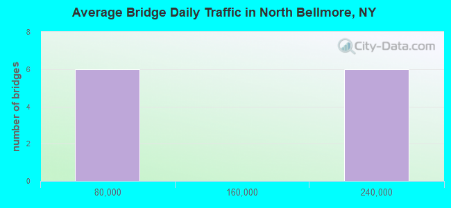
- 1,126,134Total average daily traffic
- 1,180Total average daily truck traffic
- National Bridge Inventory (NBI) Registered Bridges for North Bellmore
- No street view available for this location
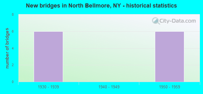
- New bridges - historical statistics
- 61930-1939
- 61950-1959
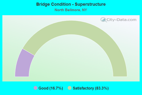
- Bridge Condition - Superstructure
- 16.7%Good
- 83.3%Satisfactory
Find on map >> Show street view
Structure Number: 1036769, Location: 1.3 MI W JCT RTS SSP+WSP (Lat: 40.693861, Lng: -73.543625), Route carried "on" structure: State highway 106, Year Built: 1930, Status: Open, Structure Length: 2.22m (7.28ft), Average Daily Traffic: 10,141 (year 2020), Truck Traffic: 4%, Average Future Daily Traffic: 11,700 (year 2040), Features Intersected: RTE 908M
Minimum Vertical Clearance: 30+ m (98+ ft), Kilometerpoint: 0.306, Lanes on structure: 5, Lanes under structure: 3, Base Highway Network: Yes, Owner: State Highway Agency, Approaching Roadway Width: 18.8m (61.7ft), Material/Design: Concrete, Design/Construction: Arch - Deck, Number Of Spans In Main Unit: 1, Length of Maximum Span: 19.8m (65.0ft), Curb or Sidewalk Widths: Left: 1.5m (4.9ft), Right: 1.5m (4.9ft), Curb-To-Curb Width: 19.0m (62.3ft), Out-to-Out Width: 23.0m (75.5ft)
Condition: Superstructure: Satisfactory, Substructure: Good, Operating Rating: 97.1 metric tons, Method Used To Determine Operating Rating: Load Factor (LF), Inventory Rating: 58.1 metric tons, Method Used To Determine Inventory Rating: Load Factor (LF), Structural Evaluation: Equal to present minimum criteria, Deck Geometry: Meets minimum limits, Underclear: High priority of corrective action, Approach Roadway Alignment: Equal to present desirable criteria, Length Of Structure Improvement: 2.22m (7.28ft), Designated Inspection Frequency: Every 24 months, Inspection Date: January 2020, Bridge Improvement Cost: $3,439,000, Roadway Improvement Cost: $2,014,000, Total Project Cost: $5,453,000 ( Estimate for 2021), Wearing Surface/Protective System: Wearing Surface: Bituminous, Membrane: Preformed Fabric
Find on map >> Show street view
Structure Number: 1057869, Location: 1.3 MI W JCT RTS SSP+WSP (Lat: 40.694144, Lng: -73.543711), Route carried "on" structure: State highway 106, Year Built: 1956, Status: Open, Structure Length: 2.31m (7.58ft), Average Daily Traffic: 10,141 (year 2020), Truck Traffic: 4%, Average Future Daily Traffic: 11,700 (year 2040), Features Intersected: RTE 908M
Minimum Vertical Clearance: 30+ m (98+ ft), Kilometerpoint: 0.338, Lanes on structure: 5, Lanes under structure: 4, Base Highway Network: Yes, Owner: State Highway Agency, Approaching Roadway Width: 18.8m (61.7ft), Material/Design: Concrete, Design/Construction: Arch - Deck, Number Of Spans In Main Unit: 1, Length of Maximum Span: 20.7m (67.9ft), Curb or Sidewalk Widths: Left: 1.5m (4.9ft), Right: 1.5m (4.9ft), Curb-To-Curb Width: 19.0m (62.3ft), Out-to-Out Width: 23.0m (75.5ft)
Condition: Superstructure: Satisfactory, Substructure: Good, Operating Rating: 89.8 metric tons, Method Used To Determine Operating Rating: Load Factor (LF), Inventory Rating: 40.8 metric tons, Method Used To Determine Inventory Rating: Load Factor (LF), Structural Evaluation: Equal to present minimum criteria, Deck Geometry: Meets minimum limits, Underclear: High priority of corrective action, Approach Roadway Alignment: Equal to present desirable criteria, Length Of Structure Improvement: 2.31m (7.58ft), Designated Inspection Frequency: Every 24 months, Inspection Date: January 2020, Bridge Improvement Cost: $4,149,000, Roadway Improvement Cost: $2,430,000, Total Project Cost: $6,578,000 ( Estimate for 2021), Wearing Surface/Protective System: Wearing Surface: Bituminous, Membrane: Preformed Fabric
Find on map >> Show street view
Structure Number: 105963, Location: .8 MI W JCT SSP & WSP (Lat: 40.698700, Lng: -73.533636), Route carried "on" structure: Other road , Year Built: 1956, Status: Open, Structure Length: 2.19m (7.19ft), Average Daily Traffic: 6,068 (year 2018), Truck Traffic: 2%, Average Future Daily Traffic: 7,507 (year 2040), Design Load: HS 20, Features Intersected: RTE 908M, Facility Carried by Structure: BELLMORE ROAD
Minimum Vertical Clearance: 30+ m (98+ ft), Kilometerpoint: 2.076, Lanes on structure: 2, Lanes under structure: 3, Owner: State Highway Agency, Approaching Roadway Width: 7.6m (24.9ft), Skew: 3 degrees, Material/Design: Concrete, Design/Construction: Arch - Deck, Number Of Spans In Main Unit: 1, Length of Maximum Span: 20.7m (67.9ft), Curb or Sidewalk Widths: Left: 1.7m (5.6ft), Right: 1.7m (5.6ft), Curb-To-Curb Width: 12.8m (42.0ft), Out-to-Out Width: 18.9m (62.0ft)
Condition: Superstructure: Satisfactory, Substructure: Good, Operating Rating: 87.4 metric tons, Method Used To Determine Operating Rating: Field evaluation and documented engineering judgment, Inventory Rating: 32.7 metric tons, Method Used To Determine Inventory Rating: Field evaluation and documented engineering judgment, Structural Evaluation: Equal to present minimum criteria, Deck Geometry: Somewhat better than minimum adequacy, Underclear: High priority of corrective action, Approach Roadway Alignment: Equal to present desirable criteria, Length Of Structure Improvement: 2.19m (7.19ft), Designated Inspection Frequency: Every 24 months, Inspection Date: July 2021, Bridge Improvement Cost: $3,336,000, Roadway Improvement Cost: $1,953,000, Total Project Cost: $5,289,000 ( Estimate for 2021), Wearing Surface/Protective System: Wearing Surface: Bituminous
Find on map >> Show street view
Structure Number: 105964, Location: .6 MI W JCT RTS SSP+WSP (Lat: 40.699672, Lng: -73.530125), Route carried "on" structure: County highway , Year Built: 1930, Status: Open, Structure Length: 2.16m (7.09ft), Average Daily Traffic: 3,214 (year 2020), Truck Traffic: 2%, Average Future Daily Traffic: 3,976 (year 2040), Features Intersected: RTE 908M, Facility Carried by Structure: OAKFIELD ROAD
Minimum Vertical Clearance: 30+ m (98+ ft), Kilometerpoint: 2.043, Lanes on structure: 2, Lanes under structure: 3, Owner: State Highway Agency, Approaching Roadway Width: 7.9m (25.9ft), Material/Design: Concrete, Design/Construction: Arch - Deck, Number Of Spans In Main Unit: 1, Length of Maximum Span: 19.2m (63.0ft), Curb or Sidewalk Widths: Left: 3.4m (11.2ft), Right: 3.3m (10.8ft), Curb-To-Curb Width: 8.0m (26.2ft), Out-to-Out Width: 16.2m (53.1ft)
Condition: Superstructure: Good, Substructure: Good, Operating Rating: 29.0 metric tons, Method Used To Determine Operating Rating: Load Factor (LF), Inventory Rating: 17.2 metric tons, Method Used To Determine Inventory Rating: Load Factor (LF), Structural Evaluation: Meets minimum limits, Deck Geometry: High priority of corrective action, Underclear: High priority of corrective action, Approach Roadway Alignment: Equal to present desirable criteria, Length Of Structure Improvement: 2.16m (7.09ft), Designated Inspection Frequency: Every 24 months, Inspection Date: January 2020, Bridge Improvement Cost: $2,354,000, Roadway Improvement Cost: $1,379,000, Total Project Cost: $3,733,000 ( Estimate for 2021), Wearing Surface/Protective System: Wearing Surface: Bituminous, Membrane: Preformed Fabric
Find on map >> Show street view
Structure Number: 152034, Location: .8 MI W JCT SSP & WSP (Lat: 40.699033, Lng: -73.533636), Route carried "on" structure: Other road , Year Built: 1930, Status: Open, Structure Length: 2.62m (8.60ft), Average Daily Traffic: 6,068 (year 2018), Truck Traffic: 2%, Average Future Daily Traffic: 7,507 (year 2040), Design Load: HS 20, Features Intersected: RTE 908M, Facility Carried by Structure: BELLMORE ROAD
Minimum Vertical Clearance: 30+ m (98+ ft), Kilometerpoint: 2.108, Lanes on structure: 2, Lanes under structure: 3, Owner: State Highway Agency, Approaching Roadway Width: 12.8m (42.0ft), Skew: 3 degrees, Material/Design: Concrete, Design/Construction: Arch - Deck, Number Of Spans In Main Unit: 1, Length of Maximum Span: 24.3m (79.7ft), Curb or Sidewalk Widths: Left: 1.7m (5.6ft), Right: 1.7m (5.6ft), Curb-To-Curb Width: 12.8m (42.0ft), Out-to-Out Width: 18.9m (62.0ft)
Condition: Superstructure: Satisfactory, Substructure: Good, Operating Rating: 90.0 metric tons, Method Used To Determine Operating Rating: Field evaluation and documented engineering judgment, Inventory Rating: 32.7 metric tons, Method Used To Determine Inventory Rating: Field evaluation and documented engineering judgment, Structural Evaluation: Equal to present minimum criteria, Deck Geometry: Somewhat better than minimum adequacy, Underclear: High priority of corrective action, Approach Roadway Alignment: Equal to present desirable criteria, Length Of Structure Improvement: 2.62m (8.60ft), Designated Inspection Frequency: Every 24 months, Inspection Date: July 2021, Bridge Improvement Cost: $3,879,000, Roadway Improvement Cost: $2,272,000, Total Project Cost: $6,150,000 ( Estimate for 2021), Wearing Surface/Protective System: Wearing Surface: Bituminous
Find on map >> Show street view
Structure Number: 152035, Location: .6 MI W JCT RTS SSP+WSP (Lat: 40.699939, Lng: -73.530203), Route carried "on" structure: County highway , Year Built: 1956, Status: Open, Structure Length: 2.25m (7.38ft), Average Daily Traffic: 3,214 (year 2020), Truck Traffic: 2%, Average Future Daily Traffic: 3,976 (year 2040), Design Load: HS 20, Features Intersected: RTE 908M, Facility Carried by Structure: OAKFIELD ROAD
Minimum Vertical Clearance: 30+ m (98+ ft), Kilometerpoint: 2.076, Lanes on structure: 2, Lanes under structure: 3, Owner: State Highway Agency, Approaching Roadway Width: 8.5m (27.9ft), Material/Design: Concrete, Design/Construction: Arch - Deck, Number Of Spans In Main Unit: 1, Length of Maximum Span: 21.0m (68.9ft), Curb or Sidewalk Widths: Left: 3.4m (11.2ft), Right: 3.1m (10.2ft), Curb-To-Curb Width: 8.4m (27.6ft), Out-to-Out Width: 16.2m (53.1ft)
Condition: Superstructure: Satisfactory, Substructure: Good, Operating Rating: 78.9 metric tons, Method Used To Determine Operating Rating: Load Factor (LF), Inventory Rating: 47.2 metric tons, Method Used To Determine Inventory Rating: Load Factor (LF), Structural Evaluation: Equal to present minimum criteria, Deck Geometry: High priority of corrective action, Underclear: High priority of corrective action, Approach Roadway Alignment: Equal to present desirable criteria, Length Of Structure Improvement: 2.25m (7.38ft), Designated Inspection Frequency: Every 24 months, Inspection Date: January 2020, Bridge Improvement Cost: $2,992,000, Roadway Improvement Cost: $1,752,000, Total Project Cost: $4,744,000 ( Estimate for 2021), Wearing Surface/Protective System: Wearing Surface: Bituminous, Membrane: Preformed Fabric
Find on map >> Show street view
Structure Number: 1036769, Location: 1.3 MI W JCT RTS SSP+WSP (Lat: 40.693861, Lng: -73.543625), Route carried "under" structure: Other road 908M, Year Built: 1930, Structure Length: 0. m, Average Daily Traffic: 187,538 (year 2002), Features Intersected: RTE 908M, Facility Carried by Structure: RTE 106
Minimum Vertical Clearance: 4.01m (13.16ft), Kilometerpoint: 16.895, Lanes on structure: 5, Lanes under structure: 3, Material/Design: Concrete, Design/Construction: Arch - Deck, Length of Maximum Span: 19.8m (65.0ft)
Find on map >> Show street view
Structure Number: 1057869, Location: 1.3 MI W JCT RTS SSP+WSP (Lat: 40.694144, Lng: -73.543711), Route carried "under" structure: State highway 908M, Year Built: 1956, Structure Length: 0. m, Average Daily Traffic: 187,538 (year 2002), Features Intersected: RTE 908M, Facility Carried by Structure: RTE 106
Minimum Vertical Clearance: 3.81m (12.50ft), Kilometerpoint: 16.895, Lanes on structure: 5, Lanes under structure: 4, Material/Design: Concrete, Design/Construction: Arch - Deck, Length of Maximum Span: 20.7m (67.9ft)
Find on map >> Show street view
Structure Number: 105963, Location: .8 MI W JCT SSP & WSP (Lat: 40.698700, Lng: -73.533636), Route carried "under" structure: State highway 908M, Year Built: 1956, Structure Length: 0. m, Average Daily Traffic: 178,053 (year 2002), Features Intersected: RTE 908M, Facility Carried by Structure: BELLMORE ROAD
Minimum Vertical Clearance: 4.17m (13.68ft), Kilometerpoint: 17.956, Lanes on structure: 2, Lanes under structure: 3, Material/Design: Concrete, Design/Construction: Arch - Deck, Length of Maximum Span: 20.7m (67.9ft)
Find on map >> Show street view
Structure Number: 105964, Location: .6 MI W JCT RTS SSP+WSP (Lat: 40.699672, Lng: -73.530125), Route carried "under" structure: State highway 908M, Year Built: 1930, Structure Length: 0. m, Average Daily Traffic: 178,053 (year 2002), Features Intersected: RTE 908M, Facility Carried by Structure: OAKFIELD ROAD
Minimum Vertical Clearance: 4.11m (13.48ft), Kilometerpoint: 18.278, Lanes on structure: 2, Lanes under structure: 3, Material/Design: Concrete, Design/Construction: Arch - Deck, Length of Maximum Span: 19.2m (63.0ft)
Find on map >> Show street view
Structure Number: 152034, Location: .8 MI W JCT SSP & WSP (Lat: 40.699033, Lng: -73.533636), Route carried "under" structure: State highway 908M, Year Built: 1930, Structure Length: 0. m, Average Daily Traffic: 178,053 (year 2002), Features Intersected: RTE 908M, Facility Carried by Structure: BELLMORE ROAD
Minimum Vertical Clearance: 3.84m (12.60ft), Kilometerpoint: 17.956, Lanes on structure: 2, Lanes under structure: 3, Material/Design: Concrete, Design/Construction: Arch - Deck, Length of Maximum Span: 24.3m (79.7ft)
Find on map >> Show street view
Structure Number: 152035, Location: .6 MI W JCT RTS SSP+WSP (Lat: 40.699939, Lng: -73.530203), Route carried "under" structure: State highway 908M, Year Built: 1956, Structure Length: 0. m, Average Daily Traffic: 178,053 (year 2002), Features Intersected: RTE 908M, Facility Carried by Structure: OAKFIELD ROAD
Minimum Vertical Clearance: 3.96m (12.99ft), Kilometerpoint: 18.278, Lanes on structure: 2, Lanes under structure: 3, Material/Design: Concrete, Design/Construction: Arch - Deck, Length of Maximum Span: 21.0m (68.9ft)