Bridge Statistics for North Boston, New York (NY)
Condition, Traffic, Stress, Structural Evaluation, Project Costs
- National Bridge Inventory (NBI) Statistics
- 19Number of bridges
- 105ft / 31.6mTotal length
- $30,335,000Total costs
- 70,434Total average daily traffic
- 3,461Total average daily truck traffic
- National Bridge Inventory (NBI) Registered Bridges for North Boston
- No street view available for this location
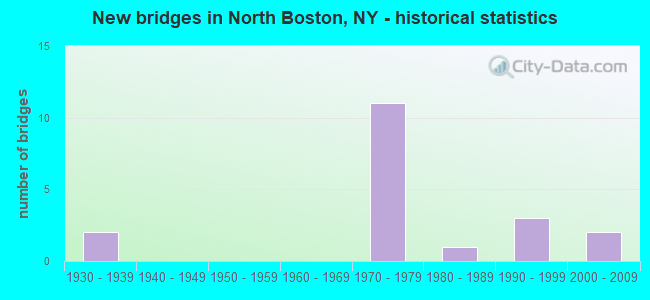
- New bridges - historical statistics
- 21930-1939
- 111970-1979
- 11980-1989
- 31990-1999
- 22000-2009

- Reconstructed bridges - Historical Statistics
- 22010-2019
- 32020-2022


- Bridge Condition - Deck
- 40.0%Excellent
- 20.0%Very good
- 40.0%Good

- Bridge Condition - Superstructure
- 20.0%Excellent
- 20.0%Very good
- 40.0%Good
- 20.0%Fair

- Bridge Condition - Substructure
- 10.0%Excellent
- 50.0%Very good
- 30.0%Good
- 10.0%Satisfactory

- Bridge Condition - Channel
- 18.2%Very good
- 27.3%Good
- 45.5%Satisfactory
- 9.1%Fair

- Bridge Condition - Culverts
- 40.0%Very good
- 20.0%Good
- 20.0%Satisfactory
- 20.0%Fair
Find on map >> Show street view
Structure Number: 104165, Location: 0.6 MI N JCT RTS 391 +219 (Lat: 42.700906, Lng: -78.792542), Route carried "on" structure: State highway 391, Year Built: 2002, Status: Open, Structure Length: 1.04m (3.41ft), Average Daily Traffic: 5,835 (year 2020), Truck Traffic: 6%, Average Future Daily Traffic: 6,161 (year 2040), Design Load: HS 25 or greater, Features Intersected: EIGHTEENMILE CK
Minimum Vertical Clearance: 30+ m (98+ ft), Kilometerpoint: 2.156, Lanes on structure: 2, Base Highway Network: Yes, Owner: State Highway Agency, Approaching Roadway Width: 11.9m (39.0ft), Material/Design: Concrete, Design/Construction: Frame, Number Of Spans In Main Unit: 1, Length of Maximum Span: 10.1m (33.1ft), Curb-To-Curb Width: 12.0m (39.4ft), Out-to-Out Width: 12.9m (42.3ft)
Condition: Deck: Excellent, Superstructure: Excellent, Substructure: Excellent, Channel: Satisfactory, Operating Rating: 79.7 metric tons, Method Used To Determine Operating Rating: Field evaluation and documented engineering judgment, Inventory Rating: 40.8 metric tons, Method Used To Determine Inventory Rating: Field evaluation and documented engineering judgment, Structural Evaluation: Superior to present desirable criteria, Deck Geometry: Somewhat better than minimum adequacy, Waterway Adequacy: Somewhat better than minimum adequacy, Approach Roadway Alignment: Somewhat better than minimum adequacy, Length Of Structure Improvement: 1.03m (3.38ft), Designated Inspection Frequency: Every 24 months, Inspection Date: June 2020, Bridge Improvement Cost: $456,000, Roadway Improvement Cost: $267,000, Total Project Cost: $723,000 ( Estimate for 2021), Wearing Surface/Protective System: Wearing Surface: Bituminous
Find on map >> Show street view
Structure Number: 10442, Location: 2.9 MI N JCT SH219 &SH277 (Lat: 42.710967, Lng: -78.747161), Route carried "on" structure: State highway 277, Year Built: 1999, Status: Open, Structure Length: 2.35m (7.71ft), Average Daily Traffic: 3,194 (year 2020), Truck Traffic: 3%, Average Future Daily Traffic: 3,372 (year 2040), Design Load: HS 25 or greater, Features Intersected: EIGHTEEN MILE CRK
Minimum Vertical Clearance: 30+ m (98+ ft), Kilometerpoint: 4.216, Lanes on structure: 2, Base Highway Network: Yes, Owner: State Highway Agency, Approaching Roadway Width: 10.1m (33.1ft), Material/Design: Steel, Design/Construction: Stringer/Multi-beam, Number Of Spans In Main Unit: 1, Length of Maximum Span: 22.0m (72.2ft), Curb-To-Curb Width: 10.2m (33.5ft), Out-to-Out Width: 11.2m (36.7ft)
Condition: Deck: Good, Superstructure: Good, Substructure: Very good, Channel: Very good, Operating Rating: 81.6 metric tons, Method Used To Determine Operating Rating: Load Factor (LF), Inventory Rating: 49.0 metric tons, Method Used To Determine Inventory Rating: Load Factor (LF), Structural Evaluation: Better than present minimum criteria, Deck Geometry: Meets minimum limits, Waterway Adequacy: Equal to present minimum criteria, Approach Roadway Alignment: Equal to present desirable criteria, Length Of Structure Improvement: 2.34m (7.68ft), Designated Inspection Frequency: Every 24 months, Inspection Date: July 2021, Bridge Improvement Cost: $1,108,000, Roadway Improvement Cost: $649,000, Total Project Cost: $1,757,000 ( Estimate for 2021), Deck Structure Type: Concrete Cast-file-Place, Wearing Surface/Protective System: Wearing Surface: Monolithic Concrete, Deck Protection: Galvanized Reinforcing
Find on map >> Show street view
Structure Number: 1092191, Location: 3.9MI S JCT RTS 20A + 219 (Lat: 42.709978, Lng: -78.785844), Route carried "on" structure: US 219, Year Built: 1977, Year Reconstructed: 2020, Status: Open, Structure Length: 4.66m (15.29ft), Average Daily Traffic: 6,843 (year 2018), Truck Traffic: 5%, Average Future Daily Traffic: 7,929 (year 2040), Design Load: HS 20, Features Intersected: ABBOTT ROAD CR 28
Minimum Vertical Clearance: 30+ m (98+ ft), Kilometerpoint: 28.705, Lanes on structure: 2, Lanes under structure: 2, Base Highway Network: Yes, Owner: State Highway Agency, Approaching Roadway Width: 12.8m (42.0ft), Skew: 5 degrees, Material/Design: Steel, Design/Construction: Stringer/Multi-beam, Number Of Spans In Main Unit: 1, Length of Maximum Span: 44.8m (147.0ft), Curb-To-Curb Width: 12.5m (41.0ft), Out-to-Out Width: 13.4m (44.0ft)
Condition: Deck: Excellent, Superstructure: Very good, Substructure: Very good, Operating Rating: 55.4 metric tons, Method Used To Determine Operating Rating: Load and Resistance Factor Rating (LRFR) rating reported by rating factor(RF) method using HL-93 loadings, Inventory Rating: 42.8 metric tons, Method Used To Determine Inventory Rating: Load and Resistance Factor Rating (LRFR) rating reported by rating factor(RF) method using HL-93 loadings, Structural Evaluation: Equal to present desirable criteria, Deck Geometry: Better than present minimum criteria, Underclear: Somewhat better than minimum adequacy, Approach Roadway Alignment: Equal to present desirable criteria, Length Of Structure Improvement: 4.66m (15.29ft), Designated Inspection Frequency: Every 24 months, Inspection Date: July 2021, Bridge Improvement Cost: $3,551,000, Roadway Improvement Cost: $2,080,000, Total Project Cost: $5,631,000 ( Estimate for 2021), Deck Structure Type: Concrete Cast-file-Place, Wearing Surface/Protective System: Wearing Surface: Integral Concrete, Deck Protection: Epoxy Coated Reinforcing
Find on map >> Show street view
Structure Number: 1092192, Location: 3.9MI S JCT RTS 20A + 219 (Lat: 42.709603, Lng: -78.785544), Route carried "on" structure: US 219, Year Built: 1977, Year Reconstructed: 2019, Status: Open, Structure Length: 4.33m (14.21ft), Average Daily Traffic: 6,843 (year 2018), Truck Traffic: 5%, Average Future Daily Traffic: 7,929 (year 2040), Design Load: HS 20, Features Intersected: ABBOTT ROAD CR 28
Minimum Vertical Clearance: 30+ m (98+ ft), Kilometerpoint: 28.705, Lanes on structure: 2, Lanes under structure: 2, Base Highway Network: Yes, Owner: State Highway Agency, Approaching Roadway Width: 12.8m (42.0ft), Skew: 4 degrees, Material/Design: Steel, Design/Construction: Stringer/Multi-beam, Number Of Spans In Main Unit: 1, Length of Maximum Span: 42.6m (139.8ft), Curb-To-Curb Width: 12.5m (41.0ft), Out-to-Out Width: 13.4m (44.0ft)
Condition: Deck: Excellent, Superstructure: Very good, Substructure: Very good, Operating Rating: 50.2 metric tons, Method Used To Determine Operating Rating: Load and Resistance Factor Rating (LRFR) rating reported by rating factor(RF) method using HL-93 loadings, Inventory Rating: 38.6 metric tons, Method Used To Determine Inventory Rating: Load and Resistance Factor Rating (LRFR) rating reported by rating factor(RF) method using HL-93 loadings, Structural Evaluation: Equal to present desirable criteria, Deck Geometry: Better than present minimum criteria, Underclear: Somewhat better than minimum adequacy, Approach Roadway Alignment: Equal to present desirable criteria, Length Of Structure Improvement: 4.32m (14.17ft), Designated Inspection Frequency: Every 24 months, Inspection Date: July 2021, Bridge Improvement Cost: $3,376,000, Roadway Improvement Cost: $1,977,000, Total Project Cost: $5,353,000 ( Estimate for 2021), Deck Structure Type: Concrete Cast-file-Place, Wearing Surface/Protective System: Wearing Surface: Integral Concrete
Find on map >> Show street view
Structure Number: 1092201, Location: 3 MI S JCT US 20A & US219 (Lat: 42.722239, Lng: -78.777775), Route carried "on" structure: US 219, Year Built: 1977, Year Reconstructed: 2020, Status: Open, Structure Length: 3.81m (12.50ft), Average Daily Traffic: 6,843 (year 2018), Truck Traffic: 5%, Average Future Daily Traffic: 7,929 (year 2040), Design Load: HS 20, Features Intersected: NEWTON ROAD CR514
Minimum Vertical Clearance: 30+ m (98+ ft), Kilometerpoint: 30.297, Lanes on structure: 2, Lanes under structure: 2, Base Highway Network: Yes, Owner: State Highway Agency, Approaching Roadway Width: 12.8m (42.0ft), Skew: 3 degrees, Material/Design: Steel, Design/Construction: Stringer/Multi-beam, Number Of Spans In Main Unit: 1, Length of Maximum Span: 36.3m (119.1ft), Curb-To-Curb Width: 12.5m (41.0ft), Out-to-Out Width: 13.4m (44.0ft)
Condition: Deck: Very good, Superstructure: Good, Substructure: Good, Operating Rating: 49.6 metric tons, Method Used To Determine Operating Rating: Load and Resistance Factor Rating (LRFR) rating reported by rating factor(RF) method using HL-93 loadings, Inventory Rating: 38.2 metric tons, Method Used To Determine Inventory Rating: Load and Resistance Factor Rating (LRFR) rating reported by rating factor(RF) method using HL-93 loadings, Structural Evaluation: Better than present minimum criteria, Deck Geometry: Better than present minimum criteria, Underclear: Somewhat better than minimum adequacy, Approach Roadway Alignment: Equal to present desirable criteria, Length Of Structure Improvement: 3.81m (12.50ft), Designated Inspection Frequency: Every 24 months, Inspection Date: December 2021, Bridge Improvement Cost: $2,671,000, Roadway Improvement Cost: $1,564,000, Total Project Cost: $4,235,000 ( Estimate for 2021), Deck Structure Type: Concrete Cast-file-Place, Wearing Surface/Protective System: Wearing Surface: Integral Concrete, Deck Protection: Epoxy Coated Reinforcing
Find on map >> Show street view
Structure Number: 1092202, Location: 3 MI S JCT US 20A & US219 (Lat: 42.722264, Lng: -78.777311), Route carried "on" structure: US 219, Year Built: 1977, Year Reconstructed: 2020, Status: Open, Structure Length: 3.81m (12.50ft), Average Daily Traffic: 6,843 (year 2018), Truck Traffic: 5%, Average Future Daily Traffic: 7,929 (year 2040), Design Load: HS 20, Features Intersected: NEWTON ROAD CR 51
Minimum Vertical Clearance: 30+ m (98+ ft), Kilometerpoint: 30.297, Lanes on structure: 2, Lanes under structure: 2, Base Highway Network: Yes, Owner: State Highway Agency, Approaching Roadway Width: 12.8m (42.0ft), Skew: 3 degrees, Material/Design: Steel, Design/Construction: Stringer/Multi-beam, Number Of Spans In Main Unit: 1, Length of Maximum Span: 36.3m (119.1ft), Curb-To-Curb Width: 12.5m (41.0ft), Out-to-Out Width: 13.4m (44.0ft)
Condition: Deck: Very good, Superstructure: Good, Substructure: Very good, Operating Rating: 49.6 metric tons, Method Used To Determine Operating Rating: Load and Resistance Factor Rating (LRFR) rating reported by rating factor(RF) method using HL-93 loadings, Inventory Rating: 38.2 metric tons, Method Used To Determine Inventory Rating: Load and Resistance Factor Rating (LRFR) rating reported by rating factor(RF) method using HL-93 loadings, Structural Evaluation: Better than present minimum criteria, Deck Geometry: Better than present minimum criteria, Underclear: Equal to present minimum criteria, Approach Roadway Alignment: Equal to present desirable criteria, Length Of Structure Improvement: 3.74m (12.27ft), Designated Inspection Frequency: Every 24 months, Inspection Date: December 2021, Bridge Improvement Cost: $2,645,000, Roadway Improvement Cost: $1,549,000, Total Project Cost: $4,194,000 ( Estimate for 2021), Deck Structure Type: Concrete Cast-file-Place, Wearing Surface/Protective System: Wearing Surface: Integral Concrete, Deck Protection: Epoxy Coated Reinforcing
Find on map >> Show street view
Structure Number: 109223, Location: 4.3MI S JCT RTS 20A & 219 (Lat: 42.703214, Lng: -78.785819), Route carried "on" structure: US 219, Year Built: 1977, Status: Open, Structure Length: 0.82m (2.69ft), Average Daily Traffic: 13,685 (year 2018), Truck Traffic: 5%, Average Future Daily Traffic: 15,858 (year 2040), Design Load: HS 20, Features Intersected: BR EIGHTEEN M CRK
Minimum Vertical Clearance: 30+ m (98+ ft), Kilometerpoint: 28.029, Lanes on structure: 4, Base Highway Network: Yes, Owner: State Highway Agency, Approaching Roadway Width: 26.2m (86.0ft), Skew: 20 degrees, Material/Design: Steel, Design/Construction: Culvert, Number Of Spans In Main Unit: 2, Length of Maximum Span: 3.9m (12.8ft)
Condition: Channel: Good, Culverts: Very good, Operating Rating: 75.4 metric tons, Method Used To Determine Operating Rating: Field evaluation and documented engineering judgment, Inventory Rating: 32.7 metric tons, Method Used To Determine Inventory Rating: Field evaluation and documented engineering judgment, Structural Evaluation: Equal to present desirable criteria, Waterway Adequacy: Meets minimum limits, Approach Roadway Alignment: Equal to present desirable criteria, Length Of Structure Improvement: 0.82m (2.69ft), Designated Inspection Frequency: Every 24 months, Inspection Date: October 2021, Bridge Improvement Cost: $596,000, Roadway Improvement Cost: $349,000, Total Project Cost: $945,000 ( Estimate for 2021), Wearing Surface/Protective System: Wearing Surface: Bituminous
Find on map >> Show street view
Structure Number: 109224, Location: 2.7MI S JCT RTS 20A & 219 (Lat: 42.725281, Lng: -78.775286), Route carried "on" structure: US 219, Year Built: 1977, Status: Open, Structure Length: 1.34m (4.40ft), Average Daily Traffic: 13,685 (year 2018), Truck Traffic: 5%, Average Future Daily Traffic: 15,858 (year 2040), Design Load: HS 20, Features Intersected: NEWMAN CREEK
Minimum Vertical Clearance: 30+ m (98+ ft), Kilometerpoint: 30.700, Lanes on structure: 4, Base Highway Network: Yes, Owner: State Highway Agency, Approaching Roadway Width: 24.4m (80.1ft), Skew: 24 degrees, Material/Design: Steel, Design/Construction: Culvert, Number Of Spans In Main Unit: 3, Length of Maximum Span: 3.6m (11.8ft)
Condition: Channel: Satisfactory, Culverts: Very good, Operating Rating: 75.1 metric tons, Method Used To Determine Operating Rating: Field evaluation and documented engineering judgment, Inventory Rating: 32.7 metric tons, Method Used To Determine Inventory Rating: Field evaluation and documented engineering judgment, Structural Evaluation: Equal to present desirable criteria, Waterway Adequacy: Meets minimum limits, Approach Roadway Alignment: Equal to present desirable criteria, Length Of Structure Improvement: 1.34m (4.40ft), Designated Inspection Frequency: Every 24 months, Inspection Date: October 2021, Bridge Improvement Cost: $904,000, Roadway Improvement Cost: $529,000, Total Project Cost: $1,433,000 ( Estimate for 2021), Wearing Surface/Protective System: Wearing Surface: Bituminous
Find on map >> Show street view
Structure Number: 225497, Location: 2.7 MI.S RTS.20A & 219 (Lat: 42.725147, Lng: -78.776383), Route carried "on" structure: Other road , Year Built: 1977, Year Reconstructed: 2018, Status: Open, Structure Length: 1.28m (4.20ft), Average Daily Traffic: 248 (year 2017), Truck Traffic: 9%, Average Future Daily Traffic: 347 (year 2037), Design Load: HS 20, Features Intersected: NEUMAN CREEK, Facility Carried by Structure: DRAUDT ROAD
Minimum Vertical Clearance: 30+ m (98+ ft), Kilometerpoint: 0.370, Lanes on structure: 2, Owner: Town or Township Highway Agency, Approaching Roadway Width: 10.4m (34.1ft), Material/Design: Steel, Design/Construction: Culvert, Number Of Spans In Main Unit: 3, Length of Maximum Span: 3.6m (11.8ft)
Condition: Channel: Fair, Culverts: Fair, Operating Rating: 74.8 metric tons, Method Used To Determine Operating Rating: Field evaluation and documented engineering judgment, Inventory Rating: 29.4 metric tons, Method Used To Determine Inventory Rating: Field evaluation and documented engineering judgment, Structural Evaluation: Somewhat better than minimum adequacy, Waterway Adequacy: Better than present minimum criteria, Approach Roadway Alignment: Equal to present desirable criteria, Length Of Structure Improvement: 1.28m (4.20ft), Designated Inspection Frequency: Every 24 months, Inspection Date: July 2020, Bridge Improvement Cost: $366,000, Roadway Improvement Cost: $215,000, Total Project Cost: $581,000 ( Estimate for 2021), Wearing Surface/Protective System: Wearing Surface: Bituminous
Find on map >> Show street view
Structure Number: 332738, Location: 1.2 MI NW OF NORTH BOSTON (Lat: 42.705731, Lng: -78.782342), Route carried "on" structure: County highway , Year Built: 1990, Status: Open, Structure Length: 1.04m (3.41ft), Average Daily Traffic: 1,505 (year 2020), Truck Traffic: 5%, Average Future Daily Traffic: 1,862 (year 2040), Design Load: HS 20, Features Intersected: BR 18 MILE CREEK, Facility Carried by Structure: ABBOTT ROAD
Minimum Vertical Clearance: 30+ m (98+ ft), Kilometerpoint: 4.747, Lanes on structure: 2, Owner: County Highway Agency, Approaching Roadway Width: 7.3m (24.0ft), Material/Design: Prestressed concrete, Design/Construction: Box Beam or Girders - Multiple, Number Of Spans In Main Unit: 1, Length of Maximum Span: 9.7m (31.8ft), Curb-To-Curb Width: 9.8m (32.2ft), Out-to-Out Width: 10.4m (34.1ft)
Condition: Deck: Good, Superstructure: Good, Substructure: Good, Channel: Satisfactory, Inventory Rating: 59.9 metric tons, Method Used To Determine Inventory Rating: Load Factor (LF), Structural Evaluation: Better than present minimum criteria, Deck Geometry: Somewhat better than minimum adequacy, Waterway Adequacy: Equal to present desirable criteria, Approach Roadway Alignment: Equal to present desirable criteria, Length Of Structure Improvement: 1.03m (3.38ft), Designated Inspection Frequency: Every 24 months, Inspection Date: May 2020, Bridge Improvement Cost: $536,000, Roadway Improvement Cost: $314,000, Total Project Cost: $850,000 ( Estimate for 2021), Deck Structure Type: Concrete Cast-file-Place, Wearing Surface/Protective System: Wearing Surface: Monolithic Concrete, Deck Protection: Epoxy Coated Reinforcing
Find on map >> Show street view
Structure Number: 332763, Location: 2 MILES N OF NEW OREGON (Lat: 42.608183, Lng: -78.819122), Route carried "on" structure: County highway , Year Built: 2004, Status: Open, Structure Length: 0.94m (3.08ft), Average Daily Traffic: 142 (year 2019), Truck Traffic: 5%, Average Future Daily Traffic: 199 (year 2039), Design Load: HS 25 or greater, Features Intersected: TRB S B 18 MI CRK, Facility Carried by Structure: NEW OREGON ROAD
Minimum Vertical Clearance: 30+ m (98+ ft), Kilometerpoint: 11.166, Lanes on structure: 2, Owner: County Highway Agency, Approaching Roadway Width: 5.8m (19.0ft), Skew: 1 degrees, Design/Construction: Stringer/Multi-beam, Number Of Spans In Main Unit: 1, Length of Maximum Span: 8.9m (29.2ft), Curb-To-Curb Width: 8.5m (27.9ft), Out-to-Out Width: 8.8m (28.9ft)
Condition: Deck: Excellent, Superstructure: Excellent, Substructure: Very good, Channel: Good, Structural Evaluation: Equal to present desirable criteria, Deck Geometry: Equal to present minimum criteria, Waterway Adequacy: Meets minimum limits, Approach Roadway Alignment: Meets minimum limits, Length Of Structure Improvement: 0.94m (3.08ft), Designated Inspection Frequency: Every 24 months, Inspection Date: October 2020, Bridge Improvement Cost: $339,000, Roadway Improvement Cost: $198,000, Total Project Cost: $537,000 ( Estimate for 2021), Wearing Surface/Protective System: Wearing Surface: Other
Find on map >> Show street view
Structure Number: 33278, Location: 2.3 MI W OF NORTH BOSTON (Lat: 42.680758, Lng: -78.821750), Route carried "on" structure: County highway , Year Built: 1983, Status: Open, Structure Length: 0.70m (2.30ft), Average Daily Traffic: 1,128 (year 2016), Truck Traffic: 2%, Average Future Daily Traffic: 1,579 (year 2036), Design Load: HS 20, Features Intersected: HAMPTON BROOK, Facility Carried by Structure: NORTH BOSTON ROAD
Minimum Vertical Clearance: 30+ m (98+ ft), Kilometerpoint: 0.451, Lanes on structure: 2, Owner: County Highway Agency, Approaching Roadway Width: 12.2m (40.0ft), Material/Design: Steel, Design/Construction: Culvert, Number Of Spans In Main Unit: 1, Length of Maximum Span: 6.7m (22.0ft)
Condition: Channel: Satisfactory, Culverts: Satisfactory, Operating Rating: 76.8 metric tons, Method Used To Determine Operating Rating: Field evaluation and documented engineering judgment, Inventory Rating: 29.4 metric tons, Method Used To Determine Inventory Rating: Field evaluation and documented engineering judgment, Structural Evaluation: Equal to present minimum criteria, Waterway Adequacy: Equal to present desirable criteria, Approach Roadway Alignment: Equal to present desirable criteria, Length Of Structure Improvement: 0.70m (2.30ft), Designated Inspection Frequency: Every 24 months, Inspection Date: April 2020, Bridge Improvement Cost: $236,000, Roadway Improvement Cost: $138,000, Total Project Cost: $374,000 ( Estimate for 2021), Wearing Surface/Protective System: Wearing Surface: Bituminous
Find on map >> Show street view
Structure Number: 332785, Location: 2.4 MI. SW OF N. BOSTON (Lat: 42.663744, Lng: -78.814989), Route carried "on" structure: Other road , Year Built: 1990, Status: Open, Structure Length: 3.23m (10.60ft), Average Daily Traffic: 477 (year 2016), Truck Traffic: 5%, Average Future Daily Traffic: 668 (year 2036), Design Load: HS 20, Features Intersected: HAMPTON BROOK, Facility Carried by Structure: KELLER ROAD
Minimum Vertical Clearance: 30+ m (98+ ft), Kilometerpoint: 0.998, Lanes on structure: 2, Owner: County Highway Agency, Approaching Roadway Width: 7.3m (24.0ft), Material/Design: Steel, Design/Construction: Stringer/Multi-beam, Number Of Spans In Main Unit: 1, Length of Maximum Span: 31.3m (102.7ft), Curb-To-Curb Width: 8.5m (27.9ft), Out-to-Out Width: 9.1m (29.9ft)
Condition: Deck: Good, Superstructure: Fair, Substructure: Good, Channel: Very good, Operating Rating: 71.3 metric tons, Method Used To Determine Operating Rating: Load and Resistance Factor Rating (LRFR) rating reported by rating factor(RF) method using HL-93 loadings, Inventory Rating: 55.1 metric tons, Method Used To Determine Inventory Rating: Load and Resistance Factor Rating (LRFR) rating reported by rating factor(RF) method using HL-93 loadings, Structural Evaluation: Somewhat better than minimum adequacy, Deck Geometry: Somewhat better than minimum adequacy, Waterway Adequacy: Equal to present minimum criteria, Approach Roadway Alignment: Equal to present desirable criteria, Length Of Structure Improvement: 3.23m (10.60ft), Designated Inspection Frequency: Every 24 months, Inspection Date: March 2021, Bridge Improvement Cost: $1,363,000, Roadway Improvement Cost: $798,000, Total Project Cost: $2,161,000 ( Estimate for 2021), Deck Structure Type: Concrete Cast-file-Place, Wearing Surface/Protective System: Wearing Surface: Integral Concrete, Deck Protection: Epoxy Coated Reinforcing
Find on map >> Show street view
Structure Number: 332788, Location: 1.3 MI N OF NORTH BOSTON (Lat: 42.710528, Lng: -78.777519), Route carried "on" structure: Other road , Year Built: 1936, Status: Posted for load-capacity, Structure Length: 1.16m (3.81ft), Average Daily Traffic: 156 (year 2016), Truck Traffic: 4%, Average Future Daily Traffic: 218 (year 2036), Features Intersected: TRIB 18 MILE CRK, Facility Carried by Structure: BUNTING ROAD
Minimum Vertical Clearance: 30+ m (98+ ft), Kilometerpoint: 0.805, Lanes on structure: 2, Owner: County Highway Agency, Approaching Roadway Width: 6.7m (22.0ft), Material/Design: Steel, Design/Construction: Stringer/Multi-beam, Number Of Spans In Main Unit: 1, Length of Maximum Span: 10.6m (34.8ft), Curb-To-Curb Width: 7.3m (24.0ft), Out-to-Out Width: 8.4m (27.6ft)
Condition: Deck: Good, Superstructure: Fair, Substructure: Satisfactory, Channel: Satisfactory, Inventory Rating: 64.4 metric tons, Method Used To Determine Inventory Rating: Load Factor (LF), Structural Evaluation: Somewhat better than minimum adequacy, Deck Geometry: Somewhat better than minimum adequacy, Waterway Adequacy: Somewhat better than minimum adequacy, Approach Roadway Alignment: Meets minimum limits, Length Of Structure Improvement: 1.15m (3.77ft), Designated Inspection Frequency: Every 24 months, Inspection Date: May 2020, Bridge Improvement Cost: $690,000, Roadway Improvement Cost: $404,000, Total Project Cost: $1,094,000 ( Estimate for 2021), Deck Structure Type: Concrete Cast-file-Place, Wearing Surface/Protective System: Wearing Surface: Bituminous
Find on map >> Show street view
Structure Number: 336229, Location: 1.9 MI N OF NORTH BOSTON (Lat: 42.711664, Lng: -78.766256), Route carried "on" structure: Other road , Year Built: 1936, Status: Open, Structure Length: 1.07m (3.51ft), Average Daily Traffic: 112 (year 2020), Truck Traffic: 4%, Average Future Daily Traffic: 157 (year 2040), Features Intersected: BR 18 MILE CREEK, Facility Carried by Structure: WARD DRIVE
Minimum Vertical Clearance: 30+ m (98+ ft), Kilometerpoint: 2.043, Lanes on structure: 2, Owner: County Highway Agency, Approaching Roadway Width: 5.5m (18.0ft), Material/Design: Steel, Design/Construction: Culvert, Number Of Spans In Main Unit: 2, Length of Maximum Span: 4.8m (15.7ft), Curb-To-Curb Width: 7.3m (24.0ft), Out-to-Out Width: 8.5m (27.9ft)
Condition: Channel: Good, Culverts: Good, Operating Rating: 73.3 metric tons, Method Used To Determine Operating Rating: Field evaluation and documented engineering judgment, Inventory Rating: 32.7 metric tons, Method Used To Determine Inventory Rating: Field evaluation and documented engineering judgment, Structural Evaluation: Better than present minimum criteria, Deck Geometry: Somewhat better than minimum adequacy, Waterway Adequacy: Meets minimum limits, Approach Roadway Alignment: Meets minimum limits, Length Of Structure Improvement: 1.06m (3.48ft), Designated Inspection Frequency: Every 24 months, Inspection Date: December 2020, Bridge Improvement Cost: $295,000, Roadway Improvement Cost: $173,000, Total Project Cost: $467,000 ( Estimate for 2021)
Find on map >> Show street view
Structure Number: 1092191, Location: 3.9MI S JCT RTS 20A + 219 (Lat: 42.709978, Lng: -78.785844), Route carried "under" structure: County highway , Year Built: 1977, Structure Length: 0. m, Average Daily Traffic: 753 (year 2020), Truck Traffic: 5%, Features Intersected: ABBOTT ROAD CR 28, Facility Carried by Structure: RTE 219
Minimum Vertical Clearance: 4.75m (15.58ft), Kilometerpoint: 3.459, Lanes on structure: 2, Lanes under structure: 2, Material/Design: Steel, Design/Construction: Stringer/Multi-beam, Length of Maximum Span: 44.8m (147.0ft)
Find on map >> Show street view
Structure Number: 1092192, Location: 3.9MI S JCT RTS 20A + 219 (Lat: 42.709603, Lng: -78.785544), Route carried "under" structure: County highway , Year Built: 1977, Structure Length: 0. m, Average Daily Traffic: 753 (year 2020), Truck Traffic: 5%, Features Intersected: ABBOTT ROAD CR 28, Facility Carried by Structure: RTE 219
Minimum Vertical Clearance: 4.57m (14.99ft), Kilometerpoint: 1.802, Lanes on structure: 2, Lanes under structure: 2, Material/Design: Steel, Design/Construction: Stringer/Multi-beam, Length of Maximum Span: 42.6m (139.8ft)
Find on map >> Show street view
Structure Number: 1092201, Location: 3 MI S JCT US 20A & US219 (Lat: 42.722239, Lng: -78.777775), Route carried "under" structure: County highway , Year Built: 1977, Structure Length: 0. m, Average Daily Traffic: 694 (year 2019), Truck Traffic: 4%, Features Intersected: NEWTON ROAD CR514, Facility Carried by Structure: RTE 219
Minimum Vertical Clearance: 4.67m (15.32ft), Kilometerpoint: 2.446, Lanes on structure: 2, Lanes under structure: 2, Material/Design: Steel, Design/Construction: Stringer/Multi-beam, Length of Maximum Span: 36.3m (119.1ft)
Find on map >> Show street view
Structure Number: 1092202, Location: 3 MI S JCT US 20A & US219 (Lat: 42.722264, Lng: -78.777311), Route carried "under" structure: County highway , Year Built: 1977, Structure Length: 0. m, Average Daily Traffic: 695 (year 2017), Truck Traffic: 3%, Features Intersected: NEWTON ROAD CR 51, Facility Carried by Structure: RTE 219
Minimum Vertical Clearance: 4.88m (16.01ft), Kilometerpoint: 3.652, Lanes on structure: 2, Lanes under structure: 2, Material/Design: Steel, Design/Construction: Stringer/Multi-beam, Length of Maximum Span: 36.3m (119.1ft)