Bridge Statistics for North Creek, Washington (WA)
Condition, Traffic, Stress, Structural Evaluation, Project Costs
- National Bridge Inventory (NBI) Statistics
- 14Number of bridges
- 118ft / 35.7mTotal length
- $37,632,000Total costs
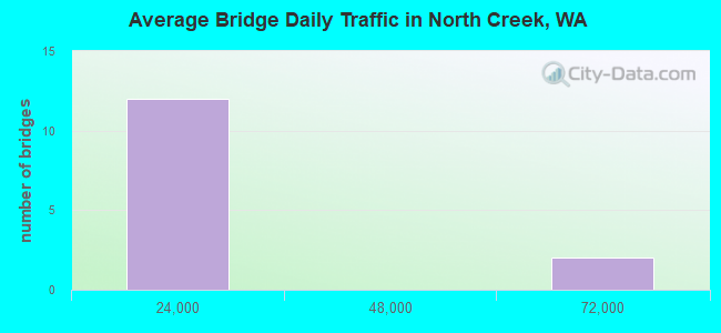
- 181,270Total average daily traffic
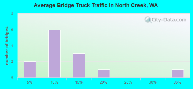
- 10,154Total average daily truck traffic
- National Bridge Inventory (NBI) Registered Bridges for North Creek
- No street view available for this location
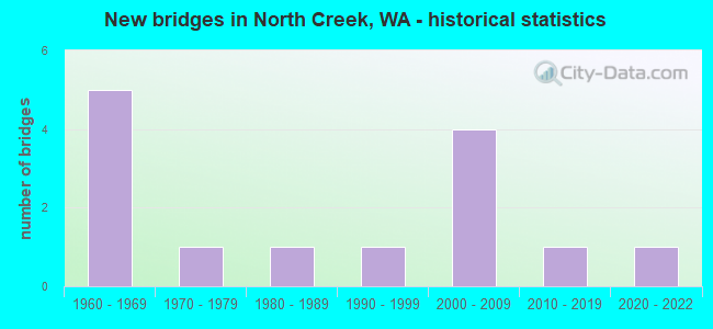
- New bridges - historical statistics
- 51960-1969
- 11970-1979
- 11980-1989
- 11990-1999
- 42000-2009
- 12010-2019
- 12020-2022
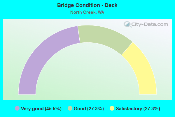
- Bridge Condition - Deck
- 45.5%Very good
- 27.3%Good
- 27.3%Satisfactory
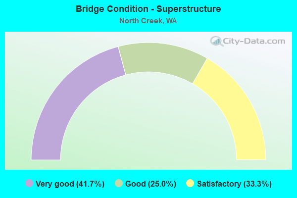
- Bridge Condition - Superstructure
- 41.7%Very good
- 25.0%Good
- 33.3%Satisfactory
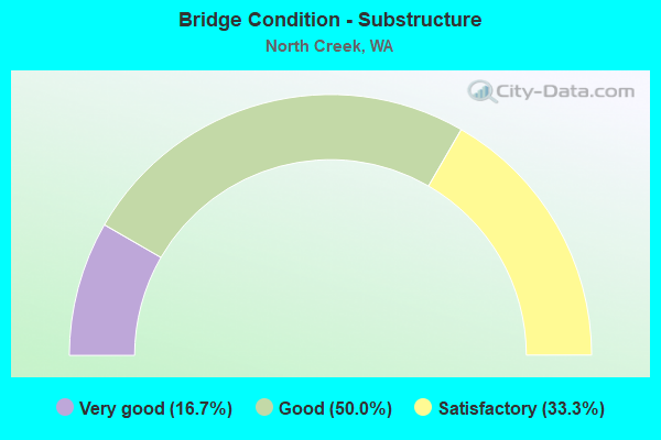
- Bridge Condition - Substructure
- 16.7%Very good
- 50.0%Good
- 33.3%Satisfactory
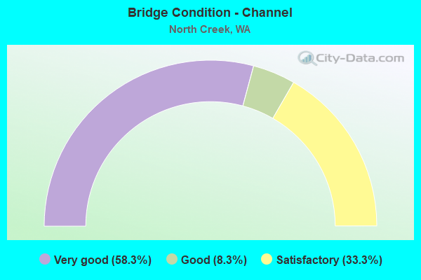
- Bridge Condition - Channel
- 58.3%Very good
- 8.3%Good
- 33.3%Satisfactory
Find on map >> Show street view
Structure Number: 8417C, Location: 2.2 N JCT SR 527 (Lat: 47.820083, Lng: -122.242056), Route carried "on" structure: Interstate 405, Year Built: 1968, Year Reconstructed: 2001, Status: Open, Structure Length: 6.46m (21.19ft), Average Daily Traffic: 64,767 (year 2019), Truck Traffic: 5%, Average Future Daily Traffic: 93,782 (year 2039), Design Load: HS 20+Mod, Features Intersected: DAMSON RD
Minimum Vertical Clearance: 30+ m (98+ ft), Kilometerpoint: 46.671, Lanes on structure: 4, Lanes under structure: 2, Base Highway Network: Yes, Owner: State Highway Agency, Approaching Roadway Width: 17.1m (56.1ft), Skew: 2 degrees, Material/Design: Prestressed concrete continuous, Design/Construction: Stringer/Multi-beam, Number Of Spans In Main Unit: 3, Length of Maximum Span: 21.6m (70.9ft), Curb or Sidewalk Widths: Left: 0.0m, Right: 0.2m (0.7ft), Curb-To-Curb Width: 16.9m (55.4ft), Out-to-Out Width: 17.8m (58.4ft)
Condition: Deck: Good, Superstructure: Good, Substructure: Good, Operating Rating: 59.9 metric tons, Method Used To Determine Operating Rating: Load Factor (LF), Inventory Rating: 35.4 metric tons, Method Used To Determine Inventory Rating: Load Factor (LF), Structural Evaluation: Better than present minimum criteria, Deck Geometry: Meets minimum limits, Underclear: Superior to present desirable criteria, Approach Roadway Alignment: Equal to present desirable criteria, Length Of Structure Improvement: 6.46m (21.19ft), Designated Inspection Frequency: Every 24 months, Inspection Date: August 2021, Bridge Improvement Cost: $2,459,000, Roadway Improvement Cost: $492,000, Total Project Cost: $4,918,000 ( Estimate for 2014), Deck Structure Type: Concrete Cast-file-Place, Wearing Surface/Protective System: Wearing Surface: Bituminous, Membrane: Preformed Fabric
Find on map >> Show street view
Structure Number: 11598A, Location: 2.9 N JCT SR 527 (Lat: 47.825250, Lng: -122.253500), Route carried "on" structure: Interstate 405, Year Built: 1968, Year Reconstructed: 2001, Status: Open, Structure Length: 10.39m (34.09ft), Average Daily Traffic: 64,767 (year 2019), Truck Traffic: 5%, Average Future Daily Traffic: 93,782 (year 2039), Design Load: HS 20+Mod, Features Intersected: SR 524 (FILBERT RD)
Minimum Vertical Clearance: 30+ m (98+ ft), Kilometerpoint: 47.717, Lanes on structure: 4, Lanes under structure: 2, Base Highway Network: Yes, Owner: State Highway Agency, Approaching Roadway Width: 24.1m (79.1ft), Material/Design: Concrete continuous, Design/Construction: Box Beam or Girders - Multiple, Number Of Spans In Main Unit: 3, Length of Maximum Span: 41.8m (137.1ft), Curb-To-Curb Width: 24.1m (79.1ft), Out-to-Out Width: 24.8m (81.4ft)
Condition: Deck: Good, Superstructure: Satisfactory, Substructure: Good, Channel: Very good, Operating Rating: 47.2 metric tons, Method Used To Determine Operating Rating: Load Factor (LF), Inventory Rating: 28.1 metric tons, Method Used To Determine Inventory Rating: Load Factor (LF), Structural Evaluation: Equal to present minimum criteria, Deck Geometry: Superior to present desirable criteria, Underclear: Better than present minimum criteria, Waterway Adequacy: Equal to present desirable criteria, Approach Roadway Alignment: Equal to present desirable criteria, Length Of Structure Improvement: 10.39m (34.09ft), Designated Inspection Frequency: Every 48 months, Inspection Date: June 2018, Bridge Improvement Cost: $5,524,000, Roadway Improvement Cost: $1,105,000, Total Project Cost: $11,048,000 ( Estimate for 2014), Deck Structure Type: Concrete Cast-file-Place, Wearing Surface/Protective System: Wearing Surface: Bituminous, Membrane: Preformed Fabric
Find on map >> Show street view
Structure Number: 16994B, Location: 0.4 N JCT SR 522 (Lat: 47.787819, Lng: -122.143692), Route carried "on" structure: ServiceOther road 9, Year Built: 2006, Status: Open, Structure Length: 1.19m (3.90ft), Average Daily Traffic: 6 (year 2015), Average Future Daily Traffic: 10 (year 2037), Design Load: HS 20+Mod, Features Intersected: LITTLE BEAR CREEK, Facility Carried by Structure: PRIVATE DRIVE
Minimum Vertical Clearance: 30+ m (98+ ft), Kilometerpoint: 0.001, Lanes on structure: 1, Owner: State Highway Agency, Approaching Roadway Width: 4.9m (16.1ft), Skew: 30 degrees, Material/Design: Prestressed concrete, Design/Construction: Slab, Number Of Spans In Main Unit: 1, Length of Maximum Span: 11.0m (36.1ft), Curb-To-Curb Width: 4.7m (15.4ft), Out-to-Out Width: 4.7m (15.4ft)
Condition: Deck: Very good, Superstructure: Very good, Substructure: Very good, Channel: Very good, Operating Rating: 33.4 metric tons, Method Used To Determine Operating Rating: Load and Resistance Factor Rating (LRFR) rating reported by rating factor(RF) method using HL-93 loadings, Inventory Rating: 25.9 metric tons, Method Used To Determine Inventory Rating: Load and Resistance Factor Rating (LRFR) rating reported by rating factor(RF) method using HL-93 loadings, Structural Evaluation: Equal to present minimum criteria, Deck Geometry: Better than present minimum criteria, Waterway Adequacy: Equal to present desirable criteria, Approach Roadway Alignment: Equal to present desirable criteria, Length Of Structure Improvement: 1.49m (4.89ft), Designated Inspection Frequency: Every 24 months, Inspection Date: November 2021, Bridge Improvement Cost: $510,000, Roadway Improvement Cost: $102,000, Total Project Cost: $1,019,000 ( Estimate for 2014), Deck Structure Type: Concrete Precast Panels, Wearing Surface/Protective System: Wearing Surface: Monolithic Concrete, Deck Protection: Epoxy Coated Reinforcing
Find on map >> Show street view
Structure Number: 8251, Location: 0.2 W JCT SR 527 (Lat: 47.820300, Lng: -122.212344), Route carried "on" structure: County highway 17740, Year Built: 1969, Status: Open, Structure Length: 0.94m (3.08ft), Average Daily Traffic: 285 (year 2017), Truck Traffic: 16%, Average Future Daily Traffic: 750 (year 2040), Design Load: HS 20, Features Intersected: NORTH CREEK, Facility Carried by Structure: 196TH ST S.E.
Minimum Vertical Clearance: 30+ m (98+ ft), Kilometerpoint: 0.001, Lanes on structure: 2, Owner: County Highway Agency, Approaching Roadway Width: 6.7m (22.0ft), Material/Design: Concrete, Design/Construction: Channel Beam, Number Of Spans In Main Unit: 1, Length of Maximum Span: 8.8m (28.9ft), Curb-To-Curb Width: 7.0m (23.0ft), Out-to-Out Width: 7.3m (24.0ft)
Condition: Deck: Satisfactory, Superstructure: Satisfactory, Substructure: Satisfactory, Channel: Satisfactory, Operating Rating: 39.9 metric tons, Method Used To Determine Operating Rating: Load Factor (LF), Inventory Rating: 34.5 metric tons, Method Used To Determine Inventory Rating: Load Factor (LF), Structural Evaluation: Equal to present minimum criteria, Deck Geometry: Meets minimum limits, Waterway Adequacy: Equal to present desirable criteria, Approach Roadway Alignment: Equal to present minimum criteria, Length Of Structure Improvement: 1.25m (4.10ft), Designated Inspection Frequency: Every 24 months, Inspection Date: November 2020, Bridge Improvement Cost: $623,000, Roadway Improvement Cost: $125,000, Total Project Cost: $1,246,000 ( Estimate for 2014), Deck Structure Type: Other, Wearing Surface/Protective System: Wearing Surface: Bituminous
Find on map >> Show street view
Structure Number: 84566, Location: 0.1 W JCT SR 9 (Lat: 47.785519, Lng: -122.145067), Route carried "on" structure: County highway 16114, Year Built: 1973, Status: Open, Structure Length: 0.94m (3.08ft), Average Daily Traffic: 4,650 (year 2017), Truck Traffic: 30%, Average Future Daily Traffic: 7,500 (year 2041), Design Load: H 15, Features Intersected: BEAR CREEK, Facility Carried by Structure: 233RD PL S.E.
Minimum Vertical Clearance: 30+ m (98+ ft), Kilometerpoint: 0.001, Lanes on structure: 2, Owner: County Highway Agency, Approaching Roadway Width: 8.5m (27.9ft), Material/Design: Concrete, Design/Construction: Channel Beam, Number Of Spans In Main Unit: 1, Length of Maximum Span: 8.8m (28.9ft), Curb-To-Curb Width: 8.6m (28.2ft), Out-to-Out Width: 8.9m (29.2ft)
Condition: Deck: Satisfactory, Superstructure: Satisfactory, Substructure: Satisfactory, Channel: Satisfactory, Operating Rating: 37.2 metric tons, Method Used To Determine Operating Rating: Load Factor (LF), Inventory Rating: 21.8 metric tons, Method Used To Determine Inventory Rating: Load Factor (LF), Structural Evaluation: Somewhat better than minimum adequacy, Deck Geometry: Meets minimum limits, Waterway Adequacy: Equal to present minimum criteria, Approach Roadway Alignment: Equal to present desirable criteria, Length Of Structure Improvement: 1.25m (4.10ft), Designated Inspection Frequency: Every 24 months, Inspection Date: October 2021, Bridge Improvement Cost: $623,000, Roadway Improvement Cost: $125,000, Total Project Cost: $1,246,000 ( Estimate for 2014), Deck Structure Type: Other, Wearing Surface/Protective System: Wearing Surface: Bituminous
Find on map >> Show street view
Structure Number: 846, Location: 0.2 N KING CO LINE (Lat: 47.778419, Lng: -122.154925), Route carried "on" structure: County highway 16100, Year Built: 1969, Status: Open, Structure Length: 0.94m (3.08ft), Average Daily Traffic: 1,480 (year 2018), Truck Traffic: 8%, Average Future Daily Traffic: 2,500 (year 2040), Design Load: HS 20, Features Intersected: BEAR CREEK, Facility Carried by Structure: 58TH AVE S.E.
Minimum Vertical Clearance: 30+ m (98+ ft), Kilometerpoint: 0.001, Lanes on structure: 2, Owner: County Highway Agency, Approaching Roadway Width: 6.7m (22.0ft), Material/Design: Concrete, Design/Construction: Channel Beam, Number Of Spans In Main Unit: 1, Length of Maximum Span: 8.5m (27.9ft), Curb-To-Curb Width: 6.9m (22.6ft), Out-to-Out Width: 7.4m (24.3ft)
Condition: Deck: Satisfactory, Superstructure: Satisfactory, Substructure: Satisfactory, Channel: Satisfactory, Operating Rating: 49.0 metric tons, Method Used To Determine Operating Rating: Load Factor (LF), Inventory Rating: 29.0 metric tons, Method Used To Determine Inventory Rating: Load Factor (LF), Structural Evaluation: Equal to present minimum criteria, Deck Geometry: High priority of corrective action, Waterway Adequacy: Equal to present minimum criteria, Approach Roadway Alignment: Equal to present desirable criteria, Length Of Structure Improvement: 1.25m (4.10ft), Designated Inspection Frequency: Every 24 months, Inspection Date: October 2020, Bridge Improvement Cost: $623,000, Roadway Improvement Cost: $125,000, Total Project Cost: $1,246,000 ( Estimate for 2014), Deck Structure Type: Other, Wearing Surface/Protective System: Wearing Surface: Bituminous
Find on map >> Show street view
Structure Number: 85748, Location: 0.1 W JCT SR 9 (Lat: 47.790369, Lng: -122.144475), Route carried "on" structure: County highway 91193, Year Built: 1989, Status: Open, Structure Length: 1.25m (4.10ft), Average Daily Traffic: 8,175 (year 2018), Truck Traffic: 10%, Average Future Daily Traffic: 12,000 (year 2042), Design Load: HS 20, Features Intersected: BEAR CREEK, Facility Carried by Structure: 228TH ST SE
Minimum Vertical Clearance: 30+ m (98+ ft), Kilometerpoint: 0.001, Lanes on structure: 4, Owner: County Highway Agency, Approaching Roadway Width: 16.2m (53.1ft), Skew: 1 degrees, Material/Design: Prestressed concrete, Design/Construction: Slab, Number Of Spans In Main Unit: 1, Length of Maximum Span: 12.2m (40.0ft), Curb-To-Curb Width: 16.2m (53.1ft), Out-to-Out Width: 17.5m (57.4ft)
Condition: Deck: Good, Superstructure: Good, Substructure: Satisfactory, Channel: Satisfactory, Operating Rating: 66.2 metric tons, Method Used To Determine Operating Rating: Load Factor (LF), Inventory Rating: 39.9 metric tons, Method Used To Determine Inventory Rating: Load Factor (LF), Structural Evaluation: Equal to present minimum criteria, Deck Geometry: Meets minimum limits, Waterway Adequacy: Equal to present desirable criteria, Approach Roadway Alignment: Equal to present desirable criteria, Length Of Structure Improvement: 1.55m (5.09ft), Designated Inspection Frequency: Every 24 months, Inspection Date: November 2020, Bridge Improvement Cost: $1,265,000, Roadway Improvement Cost: $253,000, Total Project Cost: $2,530,000 ( Estimate for 2014), Deck Structure Type: Concrete Precast Panels, Wearing Surface/Protective System: Wearing Surface: Bituminous, Deck Protection: Epoxy Coated Reinforcing
Find on map >> Show street view
Structure Number: 86032, Location: 1.0 NW JCT SR 9 (Lat: 47.811025, Lng: -122.158975), Route carried "on" structure: County highway 21670, Year Built: 1993, Status: Open, Structure Length: 1.68m (5.51ft), Average Daily Traffic: 1,037 (year 2018), Truck Traffic: 4%, Average Future Daily Traffic: 2,000 (year 2040), Design Load: HS 20, Features Intersected: BEAR CREEK, Facility Carried by Structure: BEAR CR RD
Minimum Vertical Clearance: 30+ m (98+ ft), Kilometerpoint: 0.001, Lanes on structure: 2, Owner: County Highway Agency, Approaching Roadway Width: 8.5m (27.9ft), Material/Design: Prestressed concrete, Design/Construction: Tee Beam, Number Of Spans In Main Unit: 1, Length of Maximum Span: 15.2m (49.9ft), Curb or Sidewalk Widths: Left: 0.0m, Right: 1.5m (4.9ft), Curb-To-Curb Width: 8.8m (28.9ft), Out-to-Out Width: 11.4m (37.4ft)
Condition: Deck: Very good, Superstructure: Good, Substructure: Good, Channel: Good, Operating Rating: 48.1 metric tons, Method Used To Determine Operating Rating: Load Factor (LF), Inventory Rating: 28.1 metric tons, Method Used To Determine Inventory Rating: Load Factor (LF), Structural Evaluation: Better than present minimum criteria, Deck Geometry: Somewhat better than minimum adequacy, Waterway Adequacy: Better than present minimum criteria, Approach Roadway Alignment: Equal to present desirable criteria, Length Of Structure Improvement: 1.98m (6.50ft), Designated Inspection Frequency: Every 24 months, Inspection Date: November 2020, Bridge Improvement Cost: $988,000, Roadway Improvement Cost: $198,000, Total Project Cost: $1,976,000 ( Estimate for 2014), Deck Structure Type: Other, Wearing Surface/Protective System: Wearing Surface: Bituminous, Deck Protection: Epoxy Coated Reinforcing
Find on map >> Show street view
Structure Number: 87031, Location: 0.2 E JCT SR 527 (Lat: 47.820333, Lng: -122.201694), Route carried "on" structure: County highway 17797, Year Built: 2003, Status: Open, Structure Length: 2.13m (6.99ft), Average Daily Traffic: 111 (year 2020), Truck Traffic: 10%, Average Future Daily Traffic: 300 (year 2043), Design Load: HS 25 or greater, Features Intersected: WETLAND, Facility Carried by Structure: 23RD DR SE
Minimum Vertical Clearance: 30+ m (98+ ft), Kilometerpoint: 0.001, Lanes on structure: 2, Owner: County Highway Agency, Approaching Roadway Width: 7.3m (24.0ft), Material/Design: Prestressed concrete, Design/Construction: Slab, Number Of Spans In Main Unit: 1, Length of Maximum Span: 20.7m (67.9ft), Curb or Sidewalk Widths: Left: 1.8m (5.9ft), Right: 1.8m (5.9ft), Curb-To-Curb Width: 7.3m (24.0ft), Out-to-Out Width: 11.0m (36.1ft)
Condition: Deck: Very good, Superstructure: Very good, Substructure: Good, Channel: Very good, Operating Rating: 84.4 metric tons, Method Used To Determine Operating Rating: Load Factor (LF), Inventory Rating: 50.8 metric tons, Method Used To Determine Inventory Rating: Load Factor (LF), Structural Evaluation: Better than present minimum criteria, Deck Geometry: Somewhat better than minimum adequacy, Waterway Adequacy: Equal to present minimum criteria, Approach Roadway Alignment: Equal to present desirable criteria, Length Of Structure Improvement: 2.44m (8.01ft), Designated Inspection Frequency: Every 24 months, Inspection Date: May 2021, Bridge Improvement Cost: $1,216,000, Roadway Improvement Cost: $243,000, Total Project Cost: $2,432,000 ( Estimate for 2014), Deck Structure Type: Concrete Precast Panels, Wearing Surface/Protective System: Wearing Surface: Bituminous, Membrane: Preformed Fabric, Deck Protection: Galvanized Reinforcing
Find on map >> Show street view
Structure Number: 87032, Location: 0.2 E JCT SR 527 (Lat: 47.821417, Lng: -122.201472), Route carried "on" structure: County highway 17797, Year Built: 2003, Status: Open, Structure Length: 2.77m (9.09ft), Average Daily Traffic: 111 (year 2020), Truck Traffic: 10%, Average Future Daily Traffic: 300 (year 2043), Design Load: HS 25 or greater, Features Intersected: WETLAND, Facility Carried by Structure: 194TH ST SE
Minimum Vertical Clearance: 30+ m (98+ ft), Kilometerpoint: 0.001, Lanes on structure: 2, Owner: County Highway Agency, Approaching Roadway Width: 7.3m (24.0ft), Material/Design: Prestressed concrete, Design/Construction: Tee Beam, Number Of Spans In Main Unit: 1, Length of Maximum Span: 26.2m (86.0ft), Curb or Sidewalk Widths: Left: 1.8m (5.9ft), Right: 1.8m (5.9ft), Curb-To-Curb Width: 7.3m (24.0ft), Out-to-Out Width: 11.0m (36.1ft)
Condition: Deck: Very good, Superstructure: Very good, Substructure: Good, Channel: Very good, Operating Rating: 96.1 metric tons, Method Used To Determine Operating Rating: Load Factor (LF), Inventory Rating: 42.6 metric tons, Method Used To Determine Inventory Rating: Load Factor (LF), Structural Evaluation: Better than present minimum criteria, Deck Geometry: Somewhat better than minimum adequacy, Waterway Adequacy: Equal to present desirable criteria, Approach Roadway Alignment: Equal to present desirable criteria, Length Of Structure Improvement: 3.08m (10.10ft), Designated Inspection Frequency: Every 24 months, Inspection Date: May 2021, Bridge Improvement Cost: $1,535,000, Roadway Improvement Cost: $307,000, Total Project Cost: $3,070,000 ( Estimate for 2014), Deck Structure Type: Other, Wearing Surface/Protective System: Wearing Surface: Bituminous, Membrane: Preformed Fabric, Deck Protection: Galvanized Reinforcing
Find on map >> Show street view
Structure Number: 87071, Location: .3 E JCT SR 527 (Lat: 47.821972, Lng: -122.200028), Route carried "on" structure: County highway 17793, Year Built: 2003, Status: Open, Structure Length: 2.07m (6.79ft), Average Daily Traffic: 857 (year 2020), Truck Traffic: 5%, Average Future Daily Traffic: 1,500 (year 2043), Design Load: HS 25 or greater, Features Intersected: WETLAND, Facility Carried by Structure: 24TH DR SE
Minimum Vertical Clearance: 30+ m (98+ ft), Kilometerpoint: 0.001, Lanes on structure: 2, Owner: County Highway Agency, Approaching Roadway Width: 11.0m (36.1ft), Material/Design: Prestressed concrete, Design/Construction: Tee Beam, Number Of Spans In Main Unit: 1, Length of Maximum Span: 19.5m (64.0ft), Curb or Sidewalk Widths: Left: 1.9m (6.2ft), Right: 1.9m (6.2ft), Curb-To-Curb Width: 11.0m (36.1ft), Out-to-Out Width: 14.8m (48.6ft)
Condition: Deck: Very good, Superstructure: Very good, Substructure: Good, Channel: Very good, Operating Rating: 54.4 metric tons, Method Used To Determine Operating Rating: Load Factor (LF), Inventory Rating: 32.7 metric tons, Method Used To Determine Inventory Rating: Load Factor (LF), Structural Evaluation: Better than present minimum criteria, Deck Geometry: Better than present minimum criteria, Waterway Adequacy: Equal to present desirable criteria, Approach Roadway Alignment: Equal to present desirable criteria, Length Of Structure Improvement: 2.38m (7.81ft), Designated Inspection Frequency: Every 24 months, Inspection Date: May 2021, Bridge Improvement Cost: $1,186,000, Roadway Improvement Cost: $237,000, Total Project Cost: $2,371,000 ( Estimate for 2014), Deck Structure Type: Other, Wearing Surface/Protective System: Wearing Surface: Bituminous, Membrane: Preformed Fabric, Deck Protection: Galvanized Reinforcing
Find on map >> Show street view
Structure Number: 88915, Location: 1.6 E SR 527 (Lat: 47.827464, Lng: -122.178269), Route carried "on" structure: County highway 21720, Year Built: 2015, Status: Open, Structure Length: 4.24m (13.91ft), Average Daily Traffic: 954 (year 2017), Truck Traffic: 5%, Average Future Daily Traffic: 2,000 (year 2039), Design Load: HS 20, Features Intersected: Un-named wetland, Facility Carried by Structure: 187th Pl SE
Minimum Vertical Clearance: 30+ m (98+ ft), Kilometerpoint: 0.001, Lanes on structure: 2, Owner: County Highway Agency, Approaching Roadway Width: 11.0m (36.1ft), Material/Design: Steel, Number Of Spans In Main Unit: 6, Length of Maximum Span: 6.1m (20.0ft), Curb or Sidewalk Widths: Left: 1.7m (5.6ft), Right: 1.7m (5.6ft), Curb-To-Curb Width: 11.0m (36.1ft), Out-to-Out Width: 14.9m (48.9ft)
Condition: Superstructure: Very good, Substructure: Very good, Channel: Very good, Operating Rating: 96.9 metric tons, Method Used To Determine Operating Rating: Load and Resistance Factor Rating (LRFR) rating reported by rating factor(RF) method using HL-93 loadings, Inventory Rating: 96.9 metric tons, Method Used To Determine Inventory Rating: Load and Resistance Factor Rating (LRFR) rating reported by rating factor(RF) method using HL-93 loadings, Structural Evaluation: Equal to present desirable criteria, Deck Geometry: Better than present minimum criteria, Waterway Adequacy: Equal to present desirable criteria, Approach Roadway Alignment: Equal to present desirable criteria, Length Of Structure Improvement: 4.54m (14.90ft), Designated Inspection Frequency: Every 24 months, Inspection Date: April 2021, Bridge Improvement Cost: $2,265,000, Roadway Improvement Cost: $453,000, Total Project Cost: $4,530,000 ( Estimate for 2014), Wearing Surface/Protective System: Wearing Surface: Bituminous
Find on map >> Show street view
Structure Number: 89212, Location: 0.3 E SR527 (Lat: 47.834661, Lng: -122.203050), Route carried "on" structure: County highway 18400, Year Built: 2021, Status: Open, Structure Length: 0.70m (2.30ft), Average Daily Traffic: 11,759 (year 2021), Truck Traffic: 6%, Average Future Daily Traffic: 18,000 (year 2043), Design Load: HL 93, Features Intersected: Thompson Creek, Facility Carried by Structure: 180th St. SE
Minimum Vertical Clearance: 30+ m (98+ ft), Kilometerpoint: 0.001, Lanes on structure: 5, Owner: County Highway Agency, Approaching Roadway Width: 19.2m (63.0ft), Skew: 5 degrees, Material/Design: Concrete, Design/Construction: Culvert, Number Of Spans In Main Unit: 1, Length of Maximum Span: 7.0m (23.0ft), Curb or Sidewalk Widths: Left: 2.3m (7.5ft), Right: 2.3m (7.5ft)
Condition: Channel: Very good, Culverts: Very good, Operating Rating: 38.2 metric tons, Method Used To Determine Operating Rating: Load and Resistance Factor Rating (LRFR) rating reported by rating factor(RF) method using HL-93 loadings, Inventory Rating: 22.7 metric tons, Method Used To Determine Inventory Rating: Load and Resistance Factor Rating (LRFR) rating reported by rating factor(RF) method using HL-93 loadings, Structural Evaluation: Somewhat better than minimum adequacy, Waterway Adequacy: Equal to present desirable criteria, Approach Roadway Alignment: Equal to present desirable criteria, Designated Inspection Frequency: Every 24 months, Inspection Date: August 2021, Wearing Surface/Protective System: Wearing Surface: Bituminous
Find on map >> Show street view
Structure Number: 11598A, Location: JCT I-405 (Lat: 47.825250, Lng: -122.253500), Route carried "under" structure: State highway 524, Year Built: 1968, Structure Length: 0. m, Average Daily Traffic: 22,311 (year 2019), Truck Traffic: 2%, Features Intersected: SR 524 (FILBERT RD), Facility Carried by Structure: I-405
Minimum Vertical Clearance: 16.81m (55.15ft), Kilometerpoint: 10.879, Lanes on structure: 4, Lanes under structure: 2, Material/Design: Concrete continuous, Design/Construction: Box Beam or Girders - Multiple, Length of Maximum Span: 41.8m (137.1ft)