Bridge Statistics for North Elba, New York (NY)
Condition, Traffic, Stress, Structural Evaluation, Project Costs
- National Bridge Inventory (NBI) Statistics
- 13Number of bridges
- 95ft / 29.3mTotal length
- $16,771,000Total costs
- 33,819Total average daily traffic
- 1,719Total average daily truck traffic
- National Bridge Inventory (NBI) Registered Bridges for North Elba
- No street view available for this location
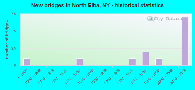
- New bridges - historical statistics
- 1Before 1900
- 11930-1939
- 11970-1979
- 21980-1989
- 11990-1999
- 72010-2019
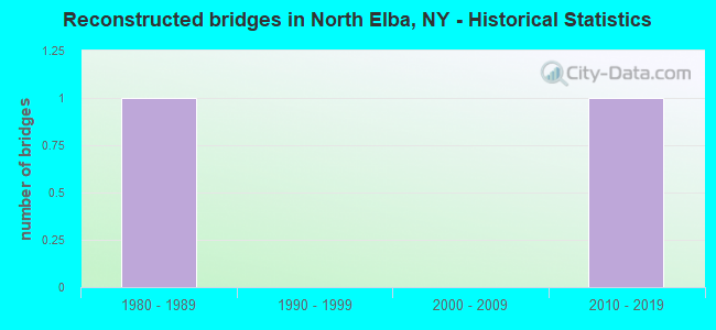
- Reconstructed bridges - Historical Statistics
- 11980-1989
- 01990-1999
- 02000-2009
- 12010-2019
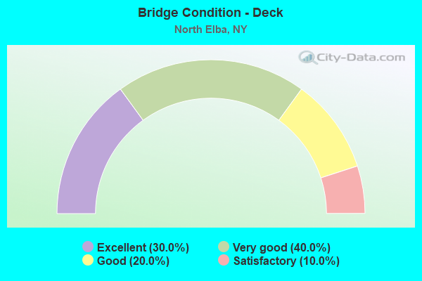
- Bridge Condition - Deck
- 30.0%Excellent
- 40.0%Very good
- 20.0%Good
- 10.0%Satisfactory
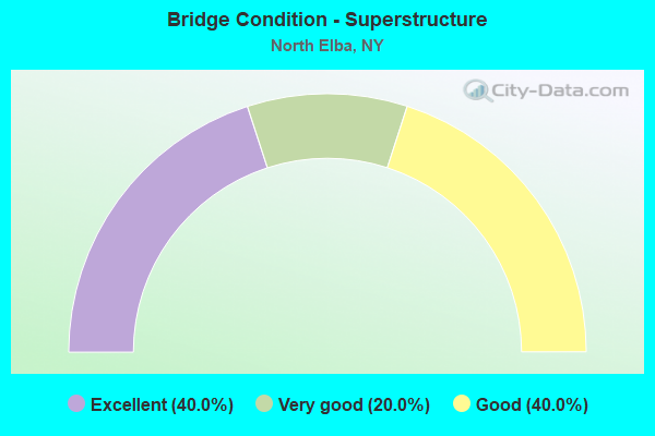
- Bridge Condition - Superstructure
- 40.0%Excellent
- 20.0%Very good
- 40.0%Good
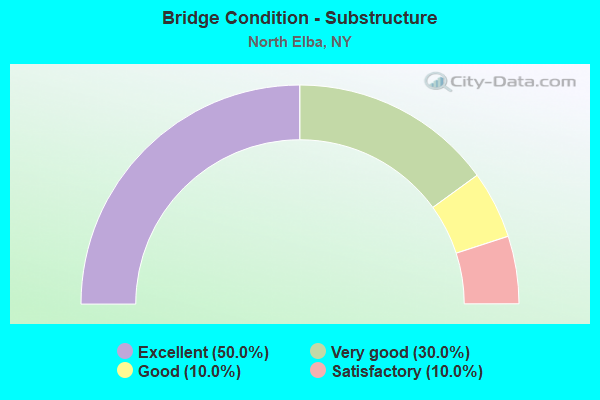
- Bridge Condition - Substructure
- 50.0%Excellent
- 30.0%Very good
- 10.0%Good
- 10.0%Satisfactory
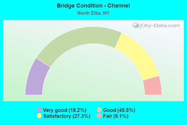
- Bridge Condition - Channel
- 18.2%Very good
- 45.5%Good
- 27.3%Satisfactory
- 9.1%Fair
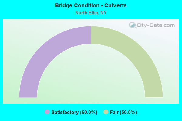
- Bridge Condition - Culverts
- 50.0%Satisfactory
- 50.0%Fair
Find on map >> Show street view
Structure Number: 103272, Location: RT 86 4.4 MI E RAY BROOK (Lat: 44.295772, Lng: -74.000083), Route carried "on" structure: US 86, Year Built: 1935, Status: Open, Structure Length: 0.82m (2.69ft), Average Daily Traffic: 9,156 (year 2016), Truck Traffic: 4%, Average Future Daily Traffic: 9,764 (year 2040), Features Intersected: OUTLET BROOK
Minimum Vertical Clearance: 30+ m (98+ ft), Kilometerpoint: 12.502, Lanes on structure: 2, Base Highway Network: Yes, Owner: State Highway Agency, Approaching Roadway Width: 9.1m (29.9ft), Skew: 1 degrees, Material/Design: Concrete continuous, Design/Construction: Culvert, Number Of Spans In Main Unit: 2, Length of Maximum Span: 3.9m (12.8ft), Curb or Sidewalk Widths: Left: 0.0m, Right: 1.5m (4.9ft)
Condition: Channel: Satisfactory, Culverts: Satisfactory, Operating Rating: 98.0 metric tons, Method Used To Determine Operating Rating: Load Factor (LF), Inventory Rating: 59.0 metric tons, Method Used To Determine Inventory Rating: Load Factor (LF), Structural Evaluation: Equal to present minimum criteria, Waterway Adequacy: Superior to present desirable criteria, Approach Roadway Alignment: Equal to present desirable criteria, Length Of Structure Improvement: 0.82m (2.69ft), Designated Inspection Frequency: Every 24 months, Inspection Date: May 2020, Bridge Improvement Cost: $255,000, Roadway Improvement Cost: $149,000, Total Project Cost: $404,000 ( Estimate for 2021), Wearing Surface/Protective System: Wearing Surface: Bituminous
Find on map >> Show street view
Structure Number: 103273, Location: 0.8 MI NE JCT RTS 86 & 73 (Lat: 44.300039, Lng: -73.929328), Route carried "on" structure: US 86, Year Built: 1973, Year Reconstructed: 2016, Status: Open, Structure Length: 5.06m (16.60ft), Average Daily Traffic: 3,495 (year 2018), Truck Traffic: 5%, Average Future Daily Traffic: 3,727 (year 2040), Design Load: HS 20, Features Intersected: WEST BRANCH AUSABLE RIVE
Minimum Vertical Clearance: 30+ m (98+ ft), Kilometerpoint: 20.434, Lanes on structure: 2, Base Highway Network: Yes, Owner: State Highway Agency, Approaching Roadway Width: 14.6m (47.9ft), Skew: 2 degrees, Material/Design: Steel, Design/Construction: Stringer/Multi-beam, Number Of Spans In Main Unit: 2, Length of Maximum Span: 24.6m (80.7ft), Curb-To-Curb Width: 14.2m (46.6ft), Out-to-Out Width: 15.2m (49.9ft)
Condition: Deck: Good, Superstructure: Good, Substructure: Good, Channel: Satisfactory, Operating Rating: 93.4 metric tons, Method Used To Determine Operating Rating: Load Factor (LF), Inventory Rating: 56.2 metric tons, Method Used To Determine Inventory Rating: Load Factor (LF), Structural Evaluation: Better than present minimum criteria, Deck Geometry: Superior to present desirable criteria, Waterway Adequacy: Superior to present desirable criteria, Approach Roadway Alignment: Equal to present desirable criteria, Length Of Structure Improvement: 5.05m (16.57ft), Designated Inspection Frequency: Every 24 months, Inspection Date: October 2020, Bridge Improvement Cost: $1,811,000, Roadway Improvement Cost: $1,061,000, Total Project Cost: $2,872,000 ( Estimate for 2021), Deck Structure Type: Concrete Cast-file-Place, Wearing Surface/Protective System: Wearing Surface: Integral Concrete, Deck Protection: Epoxy Coated Reinforcing
Find on map >> Show street view
Structure Number: 107979, Location: 1.4 MI S JCT RTS 73 & 86 (Lat: 44.256864, Lng: -73.962256), Route carried "on" structure: US 73, Year Built: 2017, Status: Open, Structure Length: 8.60m (28.22ft), Average Daily Traffic: 3,523 (year 2018), Truck Traffic: 8%, Average Future Daily Traffic: 3,757 (year 2040), Design Load: HL 93, Features Intersected: West Branch Ausable Rive
Minimum Vertical Clearance: 32.69m (107.25ft), Kilometerpoint: 41.078, Lanes on structure: 2, Owner: State Highway Agency, Approaching Roadway Width: 13.7m (44.9ft), Skew: 3 degrees, Material/Design: Steel continuous, Design/Construction: Stringer/Multi-beam, Number Of Spans In Main Unit: 2, Length of Maximum Span: 44.8m (147.0ft), Curb or Sidewalk Widths: Left: 1.6m (5.2ft), Right: 1.6m (5.2ft), Curb-To-Curb Width: 10.4m (34.1ft), Out-to-Out Width: 14.7m (48.2ft)
Condition: Deck: Very good, Superstructure: Excellent, Substructure: Excellent, Channel: Good, Structural Evaluation: Superior to present desirable criteria, Deck Geometry: Somewhat better than minimum adequacy, Waterway Adequacy: Equal to present minimum criteria, Approach Roadway Alignment: Somewhat better than minimum adequacy, Length Of Structure Improvement: 8.59m (28.18ft), Designated Inspection Frequency: Every 24 months, Inspection Date: July 2021, Bridge Improvement Cost: $2,972,000, Roadway Improvement Cost: $1,741,000, Total Project Cost: $4,713,000 ( Estimate for 2021), Deck Structure Type: Concrete Cast-file-Place, Wearing Surface/Protective System: Wearing Surface: Integral Concrete, Deck Protection: Epoxy Coated Reinforcing
Find on map >> Show street view
Structure Number: 330212, Location: 4 MI SE OF LAKE PLACID (Lat: 44.190842, Lng: -73.956697), Route carried "on" structure: Other road , Year Built: 2013, Status: Open, Structure Length: 2.19m (7.19ft), Average Daily Traffic: 781 (year 2017), Truck Traffic: 6%, Average Future Daily Traffic: 1,093 (year 2037), Design Load: HL 93, Features Intersected: W BR AUSABLE RIVR, Facility Carried by Structure: ADIRONDACK LOJ RD
Minimum Vertical Clearance: 30+ m (98+ ft), Kilometerpoint: 1.158, Lanes on structure: 2, Owner: County Highway Agency, Approaching Roadway Width: 8.2m (26.9ft), Material/Design: Prestressed concrete, Design/Construction: Channel Beam, Number Of Spans In Main Unit: 1, Length of Maximum Span: 21.3m (69.9ft), Curb-To-Curb Width: 8.2m (26.9ft), Out-to-Out Width: 9.2m (30.2ft)
Condition: Deck: Very good, Superstructure: Very good, Substructure: Excellent, Channel: Good, Operating Rating: 70.8 metric tons, Method Used To Determine Operating Rating: Load Factor (LF), Inventory Rating: 29.0 metric tons, Method Used To Determine Inventory Rating: Load Factor (LF), Structural Evaluation: Better than present minimum criteria, Deck Geometry: Somewhat better than minimum adequacy, Waterway Adequacy: Superior to present desirable criteria, Approach Roadway Alignment: Equal to present minimum criteria, Length Of Structure Improvement: 2.19m (7.19ft), Designated Inspection Frequency: Every 24 months, Inspection Date: April 2020, Bridge Improvement Cost: $1,897,000, Roadway Improvement Cost: $1,111,000, Total Project Cost: $3,008,000 ( Estimate for 2021), Wearing Surface/Protective System: Wearing Surface: Integral Concrete
Find on map >> Show street view
Structure Number: 330213, Location: 1.2 MI SE OF LAKE PLACID (Lat: 44.267236, Lng: -73.951044), Route carried "on" structure: Other road , Year Built: 1893, Year Reconstructed: 1986, Status: Open, Structure Length: 2.71m (8.89ft), Average Daily Traffic: 988 (year 2017), Truck Traffic: 6%, Average Future Daily Traffic: 1,383 (year 2037), Features Intersected: W BRANCH AUSABLE RIVER, Facility Carried by Structure: INTERVALE WAY
Minimum Vertical Clearance: 30+ m (98+ ft), Kilometerpoint: 1.722, Lanes on structure: 1, Owner: County Highway Agency, Approaching Roadway Width: 4.9m (16.1ft), Material/Design: Steel, Design/Construction: Truss - Thru, Number Of Spans In Main Unit: 1, Length of Maximum Span: 26.8m (87.9ft), Curb-To-Curb Width: 4.0m (13.1ft), Out-to-Out Width: 4.1m (13.5ft)
Condition: Deck: Very good, Superstructure: Good, Substructure: Satisfactory, Channel: Satisfactory, Operating Rating: 52.3 metric tons, Method Used To Determine Operating Rating: Field evaluation and documented engineering judgment, Inventory Rating: 19.0 metric tons, Method Used To Determine Inventory Rating: Field evaluation and documented engineering judgment, Structural Evaluation: Somewhat better than minimum adequacy, Deck Geometry: High priority of replacement, Waterway Adequacy: Equal to present desirable criteria, Approach Roadway Alignment: Meets minimum limits, Length Of Structure Improvement: 2.71m (8.89ft), Designated Inspection Frequency: Every 24 months, Critical Feature Inspection Frequency: Every 24 months, Inspection Date: May 2020, Critical Feature Inspection Date: May 2020, Bridge Improvement Cost: $707,000, Roadway Improvement Cost: $414,000, Total Project Cost: $1,121,000 ( Estimate for 2021), Deck Structure Type: Steel plate, Wearing Surface/Protective System: Wearing Surface: Other
Find on map >> Show street view
Structure Number: 330214, Location: 1.5 MI SW OF LAKE PLACID (Lat: 44.262597, Lng: -74.014144), Route carried "on" structure: County highway , Year Built: 1997, Status: Open, Structure Length: 1.86m (6.10ft), Average Daily Traffic: 1,449 (year 2017), Truck Traffic: 4%, Average Future Daily Traffic: 2,029 (year 2037), Design Load: HS 25 or greater, Features Intersected: CHUBB RIVER, Facility Carried by Structure: CR 23, AVERYVILLE
Minimum Vertical Clearance: 30+ m (98+ ft), Kilometerpoint: 3.974, Lanes on structure: 2, Owner: County Highway Agency, Approaching Roadway Width: 8.8m (28.9ft), Material/Design: Prestressed concrete, Design/Construction: Box Beam or Girders - Multiple, Number Of Spans In Main Unit: 1, Length of Maximum Span: 17.6m (57.7ft), Curb-To-Curb Width: 8.7m (28.5ft), Out-to-Out Width: 9.4m (30.8ft)
Condition: Deck: Satisfactory, Superstructure: Good, Substructure: Very good, Operating Rating: 70.8 metric tons, Method Used To Determine Operating Rating: Load Factor (LF), Inventory Rating: 41.7 metric tons, Method Used To Determine Inventory Rating: Load Factor (LF), Structural Evaluation: Better than present minimum criteria, Deck Geometry: Somewhat better than minimum adequacy, Waterway Adequacy: Superior to present desirable criteria, Approach Roadway Alignment: Equal to present minimum criteria, Length Of Structure Improvement: 1.85m (6.07ft), Designated Inspection Frequency: Every 24 months, Inspection Date: April 2021, Bridge Improvement Cost: $541,000, Roadway Improvement Cost: $317,000, Total Project Cost: $858,000 ( Estimate for 2021), Wearing Surface/Protective System: Wearing Surface: Monolithic Concrete
Find on map >> Show street view
Structure Number: 330216, Location: IN LAKE PLACID (Lat: 44.280708, Lng: -73.995436), Route carried "on" structure: County highway , Year Built: 1984, Status: Open, Structure Length: 1.16m (3.81ft), Average Daily Traffic: 5,735 (year 2016), Truck Traffic: 5%, Average Future Daily Traffic: 6,116 (year 2040), Features Intersected: OUTLET BROOK, Facility Carried by Structure: RIVER STREET EXT
Minimum Vertical Clearance: 30+ m (98+ ft), Kilometerpoint: 2.703, Lanes on structure: 2, Owner: County Highway Agency, Approaching Roadway Width: 7.9m (25.9ft), Material/Design: Steel, Design/Construction: Culvert, Number Of Spans In Main Unit: 2, Length of Maximum Span: 4.8m (15.7ft)
Condition: Channel: Fair, Culverts: Fair, Operating Rating: 73.9 metric tons, Method Used To Determine Operating Rating: Field evaluation and documented engineering judgment, Inventory Rating: 13.1 metric tons, Method Used To Determine Inventory Rating: Field evaluation and documented engineering judgment, Structural Evaluation: High priority of corrective action, Waterway Adequacy: High priority of corrective action, Approach Roadway Alignment: Equal to present minimum criteria, Length Of Structure Improvement: 1.15m (3.77ft), Designated Inspection Frequency: Every 12 months, Inspection Date: July 2021, Bridge Improvement Cost: $162,000, Roadway Improvement Cost: $95,000, Total Project Cost: $257,000 ( Estimate for 2021)
Find on map >> Show street view
Structure Number: 337043, Location: 5.3 mi SE Lake Placid (Lat: 44.225531, Lng: -73.956831), Route carried "on" structure: County highway , Year Built: 2011, Status: Open, Structure Length: 1.74m (5.71ft), Average Daily Traffic: 781 (year 2017), Truck Traffic: 6%, Average Future Daily Traffic: 1,093 (year 2037), Features Intersected: North Meadow Brook, Facility Carried by Structure: Adirondack Lodge
Minimum Vertical Clearance: 30+ m (98+ ft), Kilometerpoint: 0.000, Lanes on structure: 2, Owner: County Highway Agency, Approaching Roadway Width: 7.6m (24.9ft), Material/Design: Steel, Design/Construction: Stringer/Multi-beam, Number Of Spans In Main Unit: 1, Length of Maximum Span: 16.5m (54.1ft), Curb-To-Curb Width: 6.7m (22.0ft), Out-to-Out Width: 8.2m (26.9ft)
Condition: Deck: Very good, Superstructure: Good, Substructure: Very good, Channel: Good, Operating Rating: 84.3 metric tons, Method Used To Determine Operating Rating: Field evaluation and documented engineering judgment, Inventory Rating: 40.8 metric tons, Method Used To Determine Inventory Rating: Field evaluation and documented engineering judgment, Structural Evaluation: Better than present minimum criteria, Deck Geometry: Meets minimum limits, Waterway Adequacy: Superior to present desirable criteria, Approach Roadway Alignment: Equal to present desirable criteria, Length Of Structure Improvement: 1.73m (5.68ft), Designated Inspection Frequency: Every 24 months, Inspection Date: August 2021, Bridge Improvement Cost: $330,000, Roadway Improvement Cost: $193,000, Total Project Cost: $524,000 ( Estimate for 2021), Deck Structure Type: Other, Wearing Surface/Protective System: Wearing Surface: Integral Concrete
Find on map >> Show street view
Structure Number: 337102, Location: 2 Mi NW Rte 73 Int. (Lat: 44.275983, Lng: -73.999847), Route carried "on" structure: County highway , Year Built: 2013, Status: Open, Structure Length: 2.04m (6.69ft), Average Daily Traffic: 5,735 (year 2016), Truck Traffic: 5%, Average Future Daily Traffic: 6,116 (year 2040), Design Load: HL 93, Features Intersected: CHUBB RIVER, Facility Carried by Structure: CR 35, OLD MILITAR
Minimum Vertical Clearance: 30+ m (98+ ft), Kilometerpoint: 2.639, Lanes on structure: 2, Owner: County Highway Agency, Approaching Roadway Width: 10.1m (33.1ft), Skew: 2 degrees, Material/Design: Concrete, Design/Construction: Box Beam or Girders - Single/Spread, Number Of Spans In Main Unit: 1, Length of Maximum Span: 19.5m (64.0ft), Curb or Sidewalk Widths: Left: 3.0m (9.8ft), Right: 0.0m, Curb-To-Curb Width: 10.2m (33.5ft), Out-to-Out Width: 14.2m (46.6ft)
Condition: Deck: Good, Superstructure: Very good, Substructure: Very good, Channel: Good, Operating Rating: 84.4 metric tons, Method Used To Determine Operating Rating: Load Factor (LF), Inventory Rating: 49.9 metric tons, Method Used To Determine Inventory Rating: Load Factor (LF), Structural Evaluation: Equal to present desirable criteria, Deck Geometry: Meets minimum limits, Waterway Adequacy: Superior to present desirable criteria, Approach Roadway Alignment: Better than present minimum criteria, Length Of Structure Improvement: 2.04m (6.69ft), Designated Inspection Frequency: Every 24 months, Inspection Date: May 2021, Bridge Improvement Cost: $845,000, Roadway Improvement Cost: $495,000, Total Project Cost: $1,340,000 ( Estimate for 2021), Deck Structure Type: Concrete Cast-file-Place, Wearing Surface/Protective System: Wearing Surface: Integral Concrete, Deck Protection: Epoxy Coated Reinforcing
Find on map >> Show street view
Structure Number: 337126, Location: 0.2 MILES S. RTE. 86 (Lat: 44.293214, Lng: -73.999044), Route carried "on" structure: Other road , Year Built: 2015, Status: Open, Structure Length: 1.30m (4.27ft), Truck Traffic: 6%, Design Load: HL 93, Features Intersected: OUTLET BROOK, Facility Carried by Structure: ALGONQUIN DRIVE
Minimum Vertical Clearance: 30+ m (98+ ft), Kilometerpoint: 0.241, Lanes on structure: 2, Owner: County Highway Agency, Approaching Roadway Width: 7.3m (24.0ft), Skew: 1 degrees, Material/Design: Concrete, Design/Construction: Frame, Number Of Spans In Main Unit: 1, Length of Maximum Span: 12.7m (41.7ft), Curb-To-Curb Width: 7.3m (24.0ft), Out-to-Out Width: 8.3m (27.2ft)
Condition: Deck: Excellent, Superstructure: Excellent, Substructure: Excellent, Channel: Very good, Operating Rating: 63.5 metric tons, Method Used To Determine Operating Rating: Load Factor (LF), Inventory Rating: 38.1 metric tons, Method Used To Determine Inventory Rating: Load Factor (LF), Structural Evaluation: Superior to present desirable criteria, Deck Geometry: Equal to present minimum criteria, Waterway Adequacy: Superior to present desirable criteria, Approach Roadway Alignment: Equal to present minimum criteria, Length Of Structure Improvement: 1.30m (4.27ft), Designated Inspection Frequency: Every 24 months, Inspection Date: September 2021, Bridge Improvement Cost: $358,000, Roadway Improvement Cost: $209,000, Total Project Cost: $567,000 ( Estimate for 2021)
Find on map >> Show street view
Structure Number: 337127, Location: 1.9 MILES N. RTE. 73 (Lat: 44.274508, Lng: -73.937025), Route carried "on" structure: County highway , Year Built: 2015, Status: Open, Structure Length: 1.13m (3.71ft), Average Daily Traffic: 988 (year 2017), Truck Traffic: 6%, Average Future Daily Traffic: 1,383 (year 2037), Design Load: HL 93, Features Intersected: ROARING BROOK, Facility Carried by Structure: CR 21, RIVER ROAD
Minimum Vertical Clearance: 30+ m (98+ ft), Kilometerpoint: 3.089, Lanes on structure: 2, Owner: County Highway Agency, Approaching Roadway Width: 8.5m (27.9ft), Skew: 1 degrees, Material/Design: Concrete, Design/Construction: Frame, Number Of Spans In Main Unit: 1, Length of Maximum Span: 11.0m (36.1ft), Curb-To-Curb Width: 8.5m (27.9ft), Out-to-Out Width: 9.5m (31.2ft)
Condition: Deck: Excellent, Superstructure: Excellent, Substructure: Excellent, Channel: Very good, Inventory Rating: 66.2 metric tons, Method Used To Determine Inventory Rating: Load Factor (LF), Structural Evaluation: Superior to present desirable criteria, Deck Geometry: Somewhat better than minimum adequacy, Waterway Adequacy: Superior to present desirable criteria, Approach Roadway Alignment: Better than present minimum criteria, Length Of Structure Improvement: 1.13m (3.71ft), Designated Inspection Frequency: Every 24 months, Inspection Date: September 2021, Bridge Improvement Cost: $385,000, Roadway Improvement Cost: $225,000, Total Project Cost: $610,000 ( Estimate for 2021)
Find on map >> Show street view
Structure Number: 337128, Location: 3 MILES N. RTE. 73 (Lat: 44.286656, Lng: -73.932611), Route carried "on" structure: County highway , Year Built: 2015, Status: Open, Structure Length: 0.66m (2.17ft), Average Daily Traffic: 988 (year 2017), Truck Traffic: 6%, Average Future Daily Traffic: 1,383 (year 2037), Design Load: HL 93, Features Intersected: HOLCOMB POND BROOK, Facility Carried by Structure: CR 21, RIVER ROAD
Minimum Vertical Clearance: 30+ m (98+ ft), Kilometerpoint: 4.763, Lanes on structure: 2, Owner: County Highway Agency, Approaching Roadway Width: 8.2m (26.9ft), Skew: 1 degrees, Material/Design: Concrete, Design/Construction: Frame, Number Of Spans In Main Unit: 1, Length of Maximum Span: 6.2m (20.3ft), Curb-To-Curb Width: 8.3m (27.2ft), Out-to-Out Width: 9.4m (30.8ft)
Condition: Deck: Excellent, Superstructure: Excellent, Substructure: Excellent, Channel: Good, Operating Rating: 80.7 metric tons, Method Used To Determine Operating Rating: Load Factor (LF), Inventory Rating: 49.0 metric tons, Method Used To Determine Inventory Rating: Load Factor (LF), Structural Evaluation: Superior to present desirable criteria, Deck Geometry: Somewhat better than minimum adequacy, Waterway Adequacy: Superior to present desirable criteria, Approach Roadway Alignment: Equal to present minimum criteria, Length Of Structure Improvement: 0.65m (2.13ft), Designated Inspection Frequency: Every 24 months, Inspection Date: September 2021, Bridge Improvement Cost: $314,000, Roadway Improvement Cost: $184,000, Total Project Cost: $497,000 ( Estimate for 2021)
Find on map >> Show street view
Structure Number: 552487, Location: 0.2 MI. SW INTER. RTE. 73 (Lat: 44.224508, Lng: -73.911958), Route carried "under" structure: ServiceState lands road 913Q, Year Built: 1986, Structure Length: 0. m, Average Daily Traffic: 200 (year 2021), Features Intersected: RTE 913Q, Facility Carried by Structure: PEDESTRIAN PATH
Minimum Vertical Clearance: 5.18m (16.99ft), Kilometerpoint: 0.000, Lanes under structure: 2, Material/Design: Wood or Timber, Length of Maximum Span: 27.1m (88.9ft)