Bridge Statistics for North English, Iowa (IA)
Condition, Traffic, Stress, Structural Evaluation, Project Costs
- National Bridge Inventory (NBI) Statistics
- 13Number of bridges
- 102ft / 30.9mTotal length
- 10,445Total average daily traffic
- 846Total average daily truck traffic
- 10,445Total future (year 2039) average daily traffic
- National Bridge Inventory (NBI) Registered Bridges for North English
- No street view available for this location
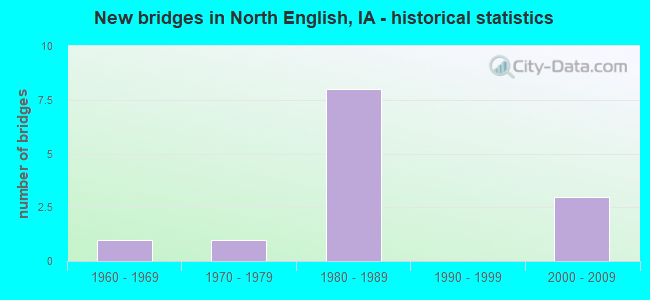
- New bridges - historical statistics
- 11960-1969
- 11970-1979
- 81980-1989
- 32000-2009

- Bridge Condition - Deck
- 37.5%Very good
- 25.0%Good
- 12.5%Satisfactory
- 12.5%Fair
- 12.5%Poor

- Bridge Condition - Superstructure
- 37.5%Very good
- 25.0%Good
- 25.0%Satisfactory
- 12.5%Fair

- Bridge Condition - Substructure
- 37.5%Very good
- 25.0%Good
- 12.5%Satisfactory
- 25.0%Serious

- Bridge Condition - Channel
- 23.1%Very good
- 30.8%Good
- 46.2%Satisfactory

- Bridge Condition - Culverts
- 60.0%Good
- 40.0%Satisfactory
Find on map >> Show street view
Structure Number: 29441, Location: 1.4 MI. N OF SR F67 (Lat: 41.537936, Lng: -92.065147), Route carried "on" structure: State highway 149, Year Built: 1987, Status: Open, Structure Length: 4.45m (14.60ft), Average Daily Traffic: 1,820 (year 2020), Truck Traffic: 9%, Average Future Daily Traffic: 1,820 (year 2041), Design Load: HS 20, Features Intersected: MIDDLE ENGLISH RIVER
Minimum Vertical Clearance: 30+ m (98+ ft), Kilometerpoint: 84.191, Lanes on structure: 2, Base Highway Network: Yes, Owner: State Highway Agency, Approaching Roadway Width: 12.2m (40.0ft), Material/Design: Prestressed concrete, Design/Construction: Stringer/Multi-beam, Number Of Spans In Main Unit: 3, Length of Maximum Span: 17.4m (57.1ft), Curb-To-Curb Width: 12.3m (40.4ft), Out-to-Out Width: 13.2m (43.3ft)
Condition: Deck: Good, Superstructure: Good, Substructure: Good, Channel: Satisfactory, Operating Rating: 67.5 metric tons, Method Used To Determine Operating Rating: Load Factor (LF), Inventory Rating: 31.0 metric tons, Method Used To Determine Inventory Rating: Load Factor (LF), Structural Evaluation: Better than present minimum criteria, Deck Geometry: Better than present minimum criteria, Waterway Adequacy: Equal to present desirable criteria, Approach Roadway Alignment: Equal to present desirable criteria, Designated Inspection Frequency: Every 24 months, Inspection Date: May 2021, Deck Structure Type: Concrete Cast-file-Place, Wearing Surface/Protective System: Wearing Surface: Monolithic Concrete, Deck Protection: Epoxy Coated Reinforcing
Find on map >> Show street view
Structure Number: 29451, Location: 0.8 MI. S OF SR V66 (Lat: 41.570953, Lng: -92.065339), Route carried "on" structure: State highway 149, Year Built: 1987, Status: Open, Structure Length: 8.56m (28.08ft), Average Daily Traffic: 1,820 (year 2020), Truck Traffic: 9%, Average Future Daily Traffic: 1,820 (year 2041), Design Load: HS 20, Features Intersected: NORTH FORK ENGLISH RIVER
Minimum Vertical Clearance: 30+ m (98+ ft), Kilometerpoint: 87.859, Lanes on structure: 2, Base Highway Network: Yes, Owner: State Highway Agency, Approaching Roadway Width: 12.2m (40.0ft), Skew: 2 degrees, Material/Design: Prestressed concrete, Design/Construction: Stringer/Multi-beam, Number Of Spans In Main Unit: 3, Length of Maximum Span: 29.6m (97.1ft), Curb-To-Curb Width: 12.2m (40.0ft), Out-to-Out Width: 13.2m (43.3ft)
Condition: Deck: Good, Superstructure: Good, Substructure: Good, Channel: Satisfactory, Operating Rating: 88.9 metric tons, Method Used To Determine Operating Rating: Load Factor (LF), Inventory Rating: 53.3 metric tons, Method Used To Determine Inventory Rating: Load Factor (LF), Structural Evaluation: Better than present minimum criteria, Deck Geometry: Better than present minimum criteria, Waterway Adequacy: Equal to present minimum criteria, Approach Roadway Alignment: Equal to present desirable criteria, Designated Inspection Frequency: Every 24 months, Underwater Inspection Frequency: Every 48 months, Inspection Date: May 2021, Underwater Inspection Date: May 2021, Deck Structure Type: Concrete Cast-file-Place, Wearing Surface/Protective System: Wearing Surface: Monolithic Concrete, Deck Protection: Epoxy Coated Reinforcing
Find on map >> Show street view
Structure Number: 188441, Location: 078112201 (Lat: 41.553622, Lng: -92.106444), Route carried "on" structure: County highway , Year Built: 2000, Status: Open, Structure Length: 2.29m (7.51ft), Average Daily Traffic: 35 (year 2018), Average Future Daily Traffic: 35 (year 2039), Design Load: HS 20+Mod, Features Intersected: BRANCH MIDDLE ENGLISH, Facility Carried by Structure: FM
Minimum Vertical Clearance: 30+ m (98+ ft), Kilometerpoint: 14.732, Lanes on structure: 2, Owner: County Highway Agency, Approaching Roadway Width: 7.9m (25.9ft), Material/Design: Prestressed concrete, Design/Construction: Stringer/Multi-beam, Number Of Spans In Main Unit: 1, Length of Maximum Span: 21.6m (70.9ft), Curb-To-Curb Width: 7.3m (24.0ft), Out-to-Out Width: 7.6m (24.9ft)
Condition: Deck: Very good, Superstructure: Very good, Substructure: Very good, Channel: Very good, Operating Rating: 66.1 metric tons, Method Used To Determine Operating Rating: Load Factor (LF), Inventory Rating: 38.5 metric tons, Method Used To Determine Inventory Rating: Load Factor (LF), Structural Evaluation: Equal to present desirable criteria, Deck Geometry: Equal to present minimum criteria, Waterway Adequacy: Equal to present desirable criteria, Approach Roadway Alignment: Better than present minimum criteria, Length Of Structure Improvement: 7.50m (24.61ft), Designated Inspection Frequency: Every 48 months, Inspection Date: March 2019, Bridge Improvement Cost: $15,000, Roadway Improvement Cost: $2,000, Deck Structure Type: Concrete Cast-file-Place, Wearing Surface/Protective System: Wearing Surface: Monolithic Concrete
Find on map >> Show street view
Structure Number: 188471, Location: 078112502 (Lat: 41.534064, Lng: -92.084300), Route carried "on" structure: County highway , Year Built: 2004, Status: Open, Structure Length: 3.84m (12.60ft), Average Daily Traffic: 140 (year 2018), Average Future Daily Traffic: 140 (year 2039), Design Load: HS 20, Features Intersected: MIDDLE FORK ENGLISH RIVE, Facility Carried by Structure: LOCAL
Minimum Vertical Clearance: 30+ m (98+ ft), Kilometerpoint: 1.846, Lanes on structure: 2, Owner: County Highway Agency, Approaching Roadway Width: 7.3m (24.0ft), Skew: 1 degrees, Material/Design: Prestressed concrete, Design/Construction: Stringer/Multi-beam, Number Of Spans In Main Unit: 3, Length of Maximum Span: 14.6m (47.9ft), Curb-To-Curb Width: 7.5m (24.6ft), Out-to-Out Width: 8.3m (27.2ft)
Condition: Deck: Very good, Superstructure: Very good, Substructure: Very good, Channel: Very good, Operating Rating: 72.6 metric tons, Method Used To Determine Operating Rating: Load Factor (LF), Inventory Rating: 37.9 metric tons, Method Used To Determine Inventory Rating: Load Factor (LF), Structural Evaluation: Equal to present desirable criteria, Deck Geometry: Somewhat better than minimum adequacy, Waterway Adequacy: Equal to present desirable criteria, Approach Roadway Alignment: Meets minimum limits, Length Of Structure Improvement: 12.60m (41.34ft), Designated Inspection Frequency: Every 48 months, Inspection Date: March 2019, Bridge Improvement Cost: $15,000, Roadway Improvement Cost: $2,000, Deck Structure Type: Concrete Cast-file-Place, Wearing Surface/Protective System: Wearing Surface: Monolithic Concrete
Find on map >> Show street view
Structure Number: 18849, Location: 078112608 (Lat: 41.528319, Lng: -92.102008), Route carried "on" structure: County highway , Year Built: 1969, Year Reconstructed: 2012, Status: Open, Structure Length: 3.14m (10.30ft), Average Daily Traffic: 610 (year 2018), Average Future Daily Traffic: 610 (year 2040), Design Load: H 20, Features Intersected: GRITTER CREEK, Facility Carried by Structure: FM
Minimum Vertical Clearance: 30+ m (98+ ft), Kilometerpoint: 2.004, Lanes on structure: 2, Owner: County Highway Agency, Approaching Roadway Width: 12.2m (40.0ft), Material/Design: Concrete continuous, Design/Construction: Slab, Number Of Spans In Main Unit: 3, Length of Maximum Span: 11.9m (39.0ft), Curb-To-Curb Width: 8.5m (27.9ft), Out-to-Out Width: 9.1m (29.9ft)
Condition: Deck: Fair, Superstructure: Fair, Substructure: Satisfactory, Channel: Good, Operating Rating: 48.7 metric tons, Method Used To Determine Operating Rating: Allowable Stress (AS), Inventory Rating: 27.5 metric tons, Method Used To Determine Inventory Rating: Allowable Stress (AS), Structural Evaluation: Somewhat better than minimum adequacy, Deck Geometry: Somewhat better than minimum adequacy, Waterway Adequacy: Better than present minimum criteria, Approach Roadway Alignment: Equal to present minimum criteria, Length Of Structure Improvement: 10.00m (32.81ft), Designated Inspection Frequency: Every 24 months, Inspection Date: March 2020, Bridge Improvement Cost: $140,000, Roadway Improvement Cost: $14,000, Deck Structure Type: Concrete Cast-file-Place, Wearing Surface/Protective System: Wearing Surface: Monolithic Concrete
Find on map >> Show street view
Structure Number: 188501, Location: 078112612 (Lat: 41.529997, Lng: -92.084747), Route carried "on" structure: County highway , Year Built: 2004, Status: Open, Structure Length: 2.65m (8.69ft), Average Daily Traffic: 140 (year 2018), Average Future Daily Traffic: 140 (year 2039), Design Load: HS 20, Features Intersected: BRANCH MIDDLE FORK ENGLI, Facility Carried by Structure: LOCAL
Minimum Vertical Clearance: 30+ m (98+ ft), Kilometerpoint: 1.390, Lanes on structure: 2, Owner: County Highway Agency, Approaching Roadway Width: 7.9m (25.9ft), Skew: 1 degrees, Material/Design: Concrete continuous, Design/Construction: Slab, Number Of Spans In Main Unit: 3, Length of Maximum Span: 10.4m (34.1ft), Curb-To-Curb Width: 7.5m (24.6ft), Out-to-Out Width: 8.3m (27.2ft)
Condition: Deck: Very good, Superstructure: Very good, Substructure: Very good, Channel: Very good, Operating Rating: 75.6 metric tons, Method Used To Determine Operating Rating: Load Factor (LF), Inventory Rating: 45.3 metric tons, Method Used To Determine Inventory Rating: Load Factor (LF), Structural Evaluation: Equal to present desirable criteria, Deck Geometry: Somewhat better than minimum adequacy, Waterway Adequacy: Equal to present desirable criteria, Approach Roadway Alignment: Equal to present minimum criteria, Length Of Structure Improvement: 8.70m (28.54ft), Designated Inspection Frequency: Every 48 months, Inspection Date: March 2019, Bridge Improvement Cost: $15,000, Roadway Improvement Cost: $2,000, Deck Structure Type: Concrete Cast-file-Place, Wearing Surface/Protective System: Wearing Surface: Monolithic Concrete
Find on map >> Show street view
Structure Number: 212921, Location: 077110304 (Lat: 41.509633, Lng: -92.113278), Route carried "on" structure: County highway , Year Built: 1972, Status: Posted for load, Structure Length: 0.94m (3.08ft), Average Daily Traffic: 10 (year 2018), Average Future Daily Traffic: 10 (year 2041), Design Load: H 15, Features Intersected: TRIB S FORK ENGLISH RIVE, Facility Carried by Structure: LOCAL
Minimum Vertical Clearance: 30+ m (98+ ft), Kilometerpoint: 5.337, Lanes on structure: 2, Owner: County Highway Agency, Approaching Roadway Width: 7.3m (24.0ft), Material/Design: Concrete, Design/Construction: Channel Beam, Number Of Spans In Main Unit: 1, Length of Maximum Span: 9.1m (29.9ft), Curb-To-Curb Width: 7.3m (24.0ft), Out-to-Out Width: 7.9m (25.9ft)
Condition: Deck: Satisfactory, Superstructure: Satisfactory, Substructure: Serious, Channel: Satisfactory, Operating Rating: 12.4 metric tons, Method Used To Determine Operating Rating: Allowable Stress (AS), Inventory Rating: 7.3 metric tons, Method Used To Determine Inventory Rating: Allowable Stress (AS), Structural Evaluation: High priority of replacement, Deck Geometry: Equal to present minimum criteria, Waterway Adequacy: Meets minimum limits, Approach Roadway Alignment: Equal to present minimum criteria, Bridge Posting: Required (Relationship of Operating Rating to Maximum Legal Load: > 39.9% below), Length Of Structure Improvement: 5.00m (16.40ft), Designated Inspection Frequency: Every 12 months, Inspection Date: March 2021, Bridge Improvement Cost: $200,000, Roadway Improvement Cost: $90,000, Deck Structure Type: Concrete Precast Panels, Wearing Surface/Protective System: Wearing Surface: Gravel
Find on map >> Show street view
Structure Number: 361821, Location: 077100503 (Lat: 41.510431, Lng: -92.042025), Route carried "on" structure: County highway , Year Built: 1983, Status: Posted for load, Structure Length: 1.34m (4.40ft), Average Daily Traffic: 10 (year 2018), Average Future Daily Traffic: 10 (year 2041), Features Intersected: DRAINAGE DITCH, Facility Carried by Structure: LOCAL
Minimum Vertical Clearance: 30+ m (98+ ft), Kilometerpoint: 7.279, Lanes on structure: 1, Owner: County Highway Agency, Approaching Roadway Width: 7.0m (23.0ft), Skew: 3 degrees, Material/Design: Wood or Timber, Design/Construction: Stringer/Multi-beam, Number Of Spans In Main Unit: 2, Length of Maximum Span: 6.4m (21.0ft), Curb-To-Curb Width: 4.6m (15.1ft), Out-to-Out Width: 4.8m (15.7ft)
Condition: Deck: Poor, Superstructure: Satisfactory, Substructure: Serious, Channel: Satisfactory, Operating Rating: 27.7 metric tons, Method Used To Determine Operating Rating: Allowable Stress (AS), Inventory Rating: 19.5 metric tons, Method Used To Determine Inventory Rating: Allowable Stress (AS), Structural Evaluation: High priority of corrective action, Deck Geometry: Better than present minimum criteria, Waterway Adequacy: Equal to present minimum criteria, Approach Roadway Alignment: Meets minimum limits, Bridge Posting: Required (Relationship of Operating Rating to Maximum Legal Load: 20.0 - 29.9% below), Length Of Structure Improvement: 7.00m (22.97ft), Designated Inspection Frequency: Every 12 months, Inspection Date: March 2021, Bridge Improvement Cost: $189,000, Roadway Improvement Cost: $19,000, Deck Structure Type: Wood or Timber, Wearing Surface/Protective System: Wearing Surface: Wood or Timber
Find on map >> Show street view
Structure Number: 3631, Location: 078103104 (Lat: 41.514981, Lng: -92.065022), Route carried "on" structure: County highway , Year Built: 1987, Status: Open, Structure Length: 0.67m (2.20ft), Average Daily Traffic: 170 (year 2018), Average Future Daily Traffic: 170 (year 2040), Design Load: HS 20, Features Intersected: SMALL, Facility Carried by Structure: FM
Minimum Vertical Clearance: 30+ m (98+ ft), Kilometerpoint: 0.509, Lanes on structure: 2, Owner: County Highway Agency, Approaching Roadway Width: 6.1m (20.0ft), Material/Design: Concrete continuous, Design/Construction: Culvert, Number Of Spans In Main Unit: 2, Length of Maximum Span: 3.0m (9.8ft)
Condition: Channel: Satisfactory, Culverts: Good, Operating Rating: 44.1 metric tons, Method Used To Determine Operating Rating: Assigned rating based on Load Factor Design (LFD) reported in metric tons, Inventory Rating: 32.7 metric tons, Method Used To Determine Inventory Rating: Assigned rating based on Load Factor Design (LFD) reported in metric tons, Structural Evaluation: Better than present minimum criteria, Waterway Adequacy: Better than present minimum criteria, Approach Roadway Alignment: Equal to present minimum criteria, Length Of Structure Improvement: 2.20m (7.22ft), Designated Inspection Frequency: Every 24 months, Inspection Date: March 2020, Bridge Improvement Cost: $15,000, Roadway Improvement Cost: $2,000
Find on map >> Show street view
Structure Number: 605775, Location: 0.9 mi. S of Jct. SR F67 (Lat: 41.510961, Lng: -92.080058), Route carried "on" structure: State highway 149, Year Built: 1987, Status: Open, Structure Length: 0.73m (2.40ft), Average Daily Traffic: 1,560 (year 2020), Truck Traffic: 11%, Average Future Daily Traffic: 1,560 (year 2041), Design Load: HS 20, Features Intersected: ENGLISH CREEK
Minimum Vertical Clearance: 30+ m (98+ ft), Kilometerpoint: 80.398, Lanes on structure: 2, Base Highway Network: Yes, Owner: State Highway Agency, Approaching Roadway Width: 13.4m (44.0ft), Skew: 3 degrees, Material/Design: Concrete continuous, Design/Construction: Culvert, Number Of Spans In Main Unit: 2, Length of Maximum Span: 3.0m (9.8ft)
Condition: Channel: Good, Culverts: Good, Operating Rating: 31.1 metric tons, Method Used To Determine Operating Rating: Load and Resistance Factor Rating (LRFR) rating reported by rating factor(RF) method using HL-93 loadings, Inventory Rating: 24.0 metric tons, Method Used To Determine Inventory Rating: Load and Resistance Factor Rating (LRFR) rating reported by rating factor(RF) method using HL-93 loadings, Structural Evaluation: Equal to present minimum criteria, Waterway Adequacy: Equal to present minimum criteria, Approach Roadway Alignment: Equal to present desirable criteria, Designated Inspection Frequency: Every 24 months, Inspection Date: August 2021
Find on map >> Show street view
Structure Number: 60578, Location: 0.4 MI. S OF SR F67 (Lat: 41.513681, Lng: -92.070558), Route carried "on" structure: State highway 149, Year Built: 1987, Status: Open, Structure Length: 0.88m (2.89ft), Average Daily Traffic: 1,610 (year 2020), Truck Traffic: 11%, Average Future Daily Traffic: 1,610 (year 2041), Design Load: HS 20, Features Intersected: ENGLISH CREEK
Minimum Vertical Clearance: 30+ m (98+ ft), Kilometerpoint: 81.246, Lanes on structure: 2, Base Highway Network: Yes, Owner: State Highway Agency, Approaching Roadway Width: 13.4m (44.0ft), Skew: 4 degrees, Material/Design: Concrete continuous, Design/Construction: Culvert, Number Of Spans In Main Unit: 2, Length of Maximum Span: 3.0m (9.8ft)
Condition: Channel: Good, Culverts: Satisfactory, Operating Rating: 34.3 metric tons, Method Used To Determine Operating Rating: Load and Resistance Factor Rating (LRFR) rating reported by rating factor(RF) method using HL-93 loadings, Inventory Rating: 26.6 metric tons, Method Used To Determine Inventory Rating: Load and Resistance Factor Rating (LRFR) rating reported by rating factor(RF) method using HL-93 loadings, Structural Evaluation: Equal to present minimum criteria, Waterway Adequacy: Equal to present minimum criteria, Approach Roadway Alignment: Equal to present desirable criteria, Designated Inspection Frequency: Every 24 months, Inspection Date: December 2021
Find on map >> Show street view
Structure Number: 605785, Location: 0.2 mi. S of Jct. SR F67 (Lat: 41.515119, Lng: -92.066497), Route carried "on" structure: State highway 149, Year Built: 1987, Status: Open, Structure Length: 0.73m (2.40ft), Average Daily Traffic: 1,720 (year 2020), Truck Traffic: 10%, Average Future Daily Traffic: 1,720 (year 2041), Design Load: HS 20, Features Intersected: ENGLISH CREEK
Minimum Vertical Clearance: 30+ m (98+ ft), Kilometerpoint: 81.623, Lanes on structure: 2, Base Highway Network: Yes, Owner: State Highway Agency, Approaching Roadway Width: 13.4m (44.0ft), Skew: 3 degrees, Material/Design: Concrete continuous, Design/Construction: Culvert, Number Of Spans In Main Unit: 2, Length of Maximum Span: 3.0m (9.8ft)
Condition: Channel: Good, Culverts: Satisfactory, Operating Rating: 75.5 metric tons, Method Used To Determine Operating Rating: Load and Resistance Factor Rating (LRFR) rating reported by rating factor(RF) method using HL-93 loadings, Inventory Rating: 58.3 metric tons, Method Used To Determine Inventory Rating: Load and Resistance Factor Rating (LRFR) rating reported by rating factor(RF) method using HL-93 loadings, Structural Evaluation: Equal to present minimum criteria, Waterway Adequacy: Equal to present minimum criteria, Approach Roadway Alignment: Equal to present minimum criteria, Designated Inspection Frequency: Every 24 months, Inspection Date: December 2021
Find on map >> Show street view
Structure Number: 605885, Location: 0.8 mi. S of Jct. SR F67 (Lat: 41.511764, Lng: -92.076458), Route carried "on" structure: City street , Year Built: 1987, Status: Open, Structure Length: 0.67m (2.20ft), Average Daily Traffic: 800 (year 2018), Average Future Daily Traffic: 800 (year 2041), Design Load: HS 20, Features Intersected: ENGLISH CREEK, Facility Carried by Structure: MAIN STREET
Minimum Vertical Clearance: 30+ m (98+ ft), Kilometerpoint: 0.200, Lanes on structure: 2, Owner: State Highway Agency, Approaching Roadway Width: 7.3m (24.0ft), Skew: 2 degrees, Material/Design: Concrete continuous, Design/Construction: Culvert, Number Of Spans In Main Unit: 2, Length of Maximum Span: 3.4m (11.2ft)
Condition: Channel: Satisfactory, Culverts: Good, Operating Rating: 29.8 metric tons, Method Used To Determine Operating Rating: Load and Resistance Factor Rating (LRFR) rating reported by rating factor(RF) method using HL-93 loadings, Inventory Rating: 23.0 metric tons, Method Used To Determine Inventory Rating: Load and Resistance Factor Rating (LRFR) rating reported by rating factor(RF) method using HL-93 loadings, Structural Evaluation: Equal to present minimum criteria, Waterway Adequacy: Better than present minimum criteria, Approach Roadway Alignment: Equal to present desirable criteria, Designated Inspection Frequency: Every 24 months, Inspection Date: December 2021