Bridge Statistics for North Irwin, Pennsylvania (PA)
Condition, Traffic, Stress, Structural Evaluation, Project Costs
- National Bridge Inventory (NBI) Statistics
- 13Number of bridges
- 135ft / 41.3mTotal length
- $1,956,000Total costs
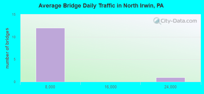
- 34,667Total average daily traffic
- 3,434Total average daily truck traffic
- National Bridge Inventory (NBI) Registered Bridges for North Irwin
- No street view available for this location
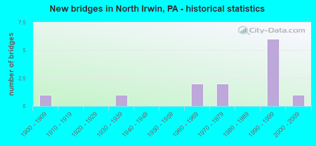
- New bridges - historical statistics
- 11900-1909
- 11930-1939
- 21960-1969
- 21970-1979
- 61990-1999
- 12000-2009
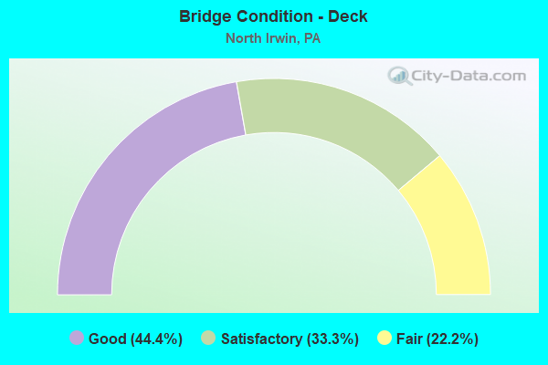
- Bridge Condition - Deck
- 44.4%Good
- 33.3%Satisfactory
- 22.2%Fair
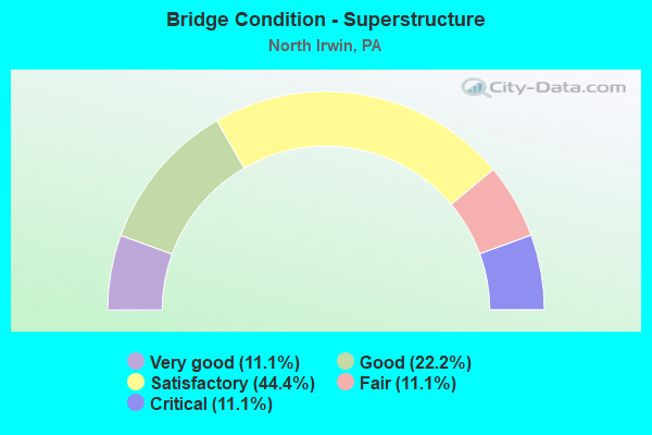
- Bridge Condition - Superstructure
- 11.1%Very good
- 22.2%Good
- 44.4%Satisfactory
- 11.1%Fair
- 11.1%Critical
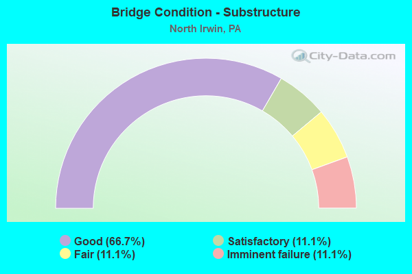
- Bridge Condition - Substructure
- 66.7%Good
- 11.1%Satisfactory
- 11.1%Fair
- 11.1%Imminent failure
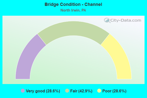
- Bridge Condition - Channel
- 28.6%Very good
- 42.9%Fair
- 28.6%Poor
Find on map >> Show street view
Structure Number: 3074, Location: RTE 422 GLADE (Lat: 40.817222, Lng: -79.569856), Route carried "on" structure: US 422, Year Built: 1961, Status: Open, Structure Length: 1.34m (4.40ft), Average Daily Traffic: 17,545 (year 2022), Truck Traffic: 13%, Average Future Daily Traffic: 15,080 (year 2032), Design Load: HS 20, Features Intersected: GLADE RUN
Minimum Vertical Clearance: 30+ m (98+ ft), Kilometerpoint: 11.093, Lanes on structure: 2, Base Highway Network: Yes, Owner: State Highway Agency, Approaching Roadway Width: 11.6m (38.1ft), Material/Design: Concrete, Design/Construction: Culvert, Number Of Spans In Main Unit: 3, Length of Maximum Span: 4.3m (14.1ft)
Condition: Channel: Fair, Culverts: Satisfactory, Operating Rating: 49.0 metric tons, Method Used To Determine Operating Rating: Field evaluation and documented engineering judgment, Inventory Rating: 32.7 metric tons, Method Used To Determine Inventory Rating: Field evaluation and documented engineering judgment, Structural Evaluation: Equal to present minimum criteria, Waterway Adequacy: Superior to present desirable criteria, Approach Roadway Alignment: Equal to present desirable criteria, Designated Inspection Frequency: Every 48 months, Inspection Date: April 2019
Find on map >> Show street view
Structure Number: 33646, Location: IRWIN TOWNSHIP (Lat: 41.215000, Lng: -79.938333), Route carried "on" structure: State highway , Year Built: 1975, Status: Open, Structure Length: 7.19m (23.59ft), Average Daily Traffic: 70 (year 2022), Truck Traffic: 3%, Average Future Daily Traffic: 141 (year 2032), Design Load: HS 20, Features Intersected: OVER SR 8,N/S R.C.FRAME, Facility Carried by Structure: SR 3102,BLAIR ROAD
Minimum Vertical Clearance: 30+ m (98+ ft), Kilometerpoint: 0.000, Lanes on structure: 2, Lanes under structure: 8, Owner: State Highway Agency, Approaching Roadway Width: 4.9m (16.1ft), Material/Design: Steel continuous, Design/Construction: Stringer/Multi-beam, Number Of Spans In Main Unit: 2, Length of Maximum Span: 35.4m (116.1ft), Curb or Sidewalk Widths: Left: 0.2m (0.7ft), Right: 0.2m (0.7ft), Curb-To-Curb Width: 11.0m (36.1ft), Out-to-Out Width: 12.2m (40.0ft)
Condition: Deck: Good, Superstructure: Satisfactory, Substructure: Good, Operating Rating: 77.1 metric tons, Method Used To Determine Operating Rating: Load Factor (LF), Inventory Rating: 46.3 metric tons, Method Used To Determine Inventory Rating: Load Factor (LF), Structural Evaluation: Equal to present minimum criteria, Deck Geometry: Superior to present desirable criteria, Underclear: Equal to present minimum criteria, Approach Roadway Alignment: Equal to present desirable criteria, Length Of Structure Improvement: 7.20m (23.62ft), Designated Inspection Frequency: Every 24 months, Inspection Date: June 2020, Bridge Improvement Cost: $10,000, Roadway Improvement Cost: $28,000, Total Project Cost: $130,000, Deck Structure Type: Concrete Cast-file-Place, Wearing Surface/Protective System: Wearing Surface: Monolithic Concrete
Find on map >> Show street view
Structure Number: 36352, Location: NORTH HUNTINGDON TOWNSHIP (Lat: 40.343872, Lng: -79.724617), Route carried "on" structure: State highway 993, Year Built: 1937, Year Reconstructed: 2010, Status: Open, Structure Length: 4.66m (15.29ft), Average Daily Traffic: 3,820 (year 2022), Truck Traffic: 7%, Average Future Daily Traffic: 7,133 (year 2032), Design Load: HS 20, Features Intersected: BRUSH CREEK
Minimum Vertical Clearance: 4.82m (15.81ft), Kilometerpoint: 6.180, Lanes on structure: 2, Owner: State Highway Agency, Approaching Roadway Width: 12.8m (42.0ft), Skew: 4 degrees, Material/Design: Steel, Design/Construction: Truss - Thru, Number Of Spans In Main Unit: 1, Length of Maximum Span: 44.5m (146.0ft), Curb or Sidewalk Widths: Left: 0.0m, Right: 1.7m (5.6ft), Curb-To-Curb Width: 12.4m (40.7ft), Out-to-Out Width: 13.4m (44.0ft)
Condition: Deck: Satisfactory, Superstructure: Very good, Substructure: Good, Channel: Fair, Operating Rating: 65.3 metric tons, Method Used To Determine Operating Rating: Load Factor (LF), Inventory Rating: 39.0 metric tons, Method Used To Determine Inventory Rating: Load Factor (LF), Structural Evaluation: Better than present minimum criteria, Deck Geometry: Equal to present minimum criteria, Waterway Adequacy: Meets minimum limits, Approach Roadway Alignment: Equal to present desirable criteria, Length Of Structure Improvement: 4.50m (14.76ft), Designated Inspection Frequency: Every 24 months, Critical Feature Inspection Frequency: Every 24 months, Inspection Date: July 2021, Critical Feature Inspection Date: July 2021, Bridge Improvement Cost: $79,000, Roadway Improvement Cost: $233,000, Total Project Cost: $1,069,000, Deck Structure Type: Concrete Cast-file-Place, Wearing Surface/Protective System: Wearing Surface: Monolithic Concrete, Deck Protection: Epoxy Coated Reinforcing
Find on map >> Show street view
Structure Number: 36354, Location: NORTH HUNTINGDON TOWNSHIP (Lat: 40.338331, Lng: -79.718253), Route carried "on" structure: State highway 993, Year Built: 1990, Status: Open, Structure Length: 3.51m (11.52ft), Average Daily Traffic: 3,339 (year 2020), Truck Traffic: 9%, Average Future Daily Traffic: 5,366 (year 2042), Design Load: HS 25 or greater, Features Intersected: BRUSH CREEK
Minimum Vertical Clearance: 30+ m (98+ ft), Kilometerpoint: 7.525, Lanes on structure: 2, Owner: State Highway Agency, Approaching Roadway Width: 11.0m (36.1ft), Skew: 4 degrees, Material/Design: Prestressed concrete, Design/Construction: Box Beam or Girders - Single/Spread, Number Of Spans In Main Unit: 2, Length of Maximum Span: 17.4m (57.1ft), Curb or Sidewalk Widths: Left: 0.2m (0.7ft), Right: 0.2m (0.7ft), Curb-To-Curb Width: 11.0m (36.1ft), Out-to-Out Width: 12.0m (39.4ft)
Condition: Deck: Good, Superstructure: Satisfactory, Substructure: Good, Channel: Fair, Inventory Rating: 48.1 metric tons, Method Used To Determine Inventory Rating: Load Factor (LF), Structural Evaluation: Equal to present minimum criteria, Deck Geometry: Somewhat better than minimum adequacy, Waterway Adequacy: Somewhat better than minimum adequacy, Approach Roadway Alignment: Equal to present desirable criteria, Length Of Structure Improvement: 4.60m (15.09ft), Designated Inspection Frequency: Every 48 months, Inspection Date: July 2019, Deck Structure Type: Concrete Cast-file-Place, Wearing Surface/Protective System: Wearing Surface: Monolithic Concrete, Deck Protection: Epoxy Coated Reinforcing
Find on map >> Show street view
Structure Number: 36355, Location: NORTH HUNTINGDON TOWNSHIP (Lat: 40.334575, Lng: -79.716706), Route carried "on" structure: State highway 993, Year Built: 1961, Status: Open, Structure Length: 4.27m (14.01ft), Average Daily Traffic: 3,339 (year 2020), Truck Traffic: 9%, Average Future Daily Traffic: 5,366 (year 2032), Design Load: HS 20, Features Intersected: BRUSH CREEK
Minimum Vertical Clearance: 30+ m (98+ ft), Kilometerpoint: 7.525, Lanes on structure: 2, Owner: State Highway Agency, Approaching Roadway Width: 6.7m (22.0ft), Skew: 4 degrees, Material/Design: Prestressed concrete, Design/Construction: Box Beam or Girders - Single/Spread, Number Of Spans In Main Unit: 2, Length of Maximum Span: 20.4m (66.9ft), Curb or Sidewalk Widths: Left: 0.5m (1.6ft), Right: 0.5m (1.6ft), Curb-To-Curb Width: 12.2m (40.0ft), Out-to-Out Width: 13.9m (45.6ft)
Condition: Deck: Fair, Superstructure: Fair, Substructure: Fair, Channel: Poor, Operating Rating: 81.6 metric tons, Method Used To Determine Operating Rating: Load Factor (LF), Inventory Rating: 49.0 metric tons, Method Used To Determine Inventory Rating: Load Factor (LF), Structural Evaluation: Somewhat better than minimum adequacy, Deck Geometry: Equal to present minimum criteria, Waterway Adequacy: Superior to present desirable criteria, Approach Roadway Alignment: Better than present minimum criteria, Length Of Structure Improvement: 5.20m (17.06ft), Designated Inspection Frequency: Every 24 months, Inspection Date: July 2021, Deck Structure Type: Concrete Cast-file-Place, Wearing Surface/Protective System: Wearing Surface: Monolithic Concrete
Find on map >> Show street view
Structure Number: 36717, Location: NORTH HUNTINGDON TOWNSHIP (Lat: 40.337664, Lng: -79.707194), Route carried "on" structure: State highway , Year Built: 1971, Status: Open, Structure Length: 0.91m (2.99ft), Average Daily Traffic: 1,525 (year 2022), Truck Traffic: 1%, Average Future Daily Traffic: 2,075 (year 2032), Design Load: HS 20, Features Intersected: COAL RUN, Facility Carried by Structure: SR 4027
Minimum Vertical Clearance: 30+ m (98+ ft), Kilometerpoint: 0.161, Lanes on structure: 2, Owner: State Highway Agency, Approaching Roadway Width: 13.7m (44.9ft), Skew: 4 degrees, Material/Design: Concrete, Design/Construction: Slab, Number Of Spans In Main Unit: 1, Length of Maximum Span: 7.9m (25.9ft), Curb-To-Curb Width: 13.8m (45.3ft), Out-to-Out Width: 14.6m (47.9ft)
Condition: Deck: Satisfactory, Superstructure: Satisfactory, Substructure: Satisfactory, Channel: Poor, Operating Rating: 65.3 metric tons, Method Used To Determine Operating Rating: Load Factor (LF), Inventory Rating: 39.0 metric tons, Method Used To Determine Inventory Rating: Load Factor (LF), Structural Evaluation: Equal to present minimum criteria, Deck Geometry: Superior to present desirable criteria, Waterway Adequacy: Meets minimum limits, Approach Roadway Alignment: Equal to present desirable criteria, Length Of Structure Improvement: 1.40m (4.59ft), Designated Inspection Frequency: Every 24 months, Inspection Date: Febuary 2020, Wearing Surface/Protective System: Wearing Surface: Bituminous
Find on map >> Show street view
Structure Number: 36871, Location: AT RTE 993 IN LARIMER (Lat: 40.349861, Lng: -79.731883), Route carried "on" structure: City street B0R0, Year Built: 1991, Status: Open, Structure Length: 4.33m (14.21ft), Average Daily Traffic: 50 (year 2012), Truck Traffic: 5%, Average Future Daily Traffic: 70 (year 2032), Design Load: HS 25 or greater, Features Intersected: NORFOLK SOUTHERN, Facility Carried by Structure: BARNER HILL RD
Minimum Vertical Clearance: 30+ m (98+ ft), Kilometerpoint: 0.000, Lanes on structure: 2, Owner: Town or Township Highway Agency, Approaching Roadway Width: 7.6m (24.9ft), Material/Design: Steel, Design/Construction: Stringer/Multi-beam, Number Of Spans In Main Unit: 2, Length of Maximum Span: 22.6m (74.1ft), Curb or Sidewalk Widths: Left: 0.2m (0.7ft), Right: 0.2m (0.7ft), Curb-To-Curb Width: 7.6m (24.9ft), Out-to-Out Width: 8.7m (28.5ft)
Condition: Deck: Good, Superstructure: Good, Substructure: Good, Operating Rating: 49.9 metric tons, Method Used To Determine Operating Rating: Load Factor (LF), Inventory Rating: 29.9 metric tons, Method Used To Determine Inventory Rating: Load Factor (LF), Structural Evaluation: Better than present minimum criteria, Deck Geometry: Equal to present minimum criteria, Underclear: High priority of corrective action, Approach Roadway Alignment: Meets minimum limits, Length Of Structure Improvement: 5.20m (17.06ft), Designated Inspection Frequency: Every 24 months, Inspection Date: November 2020, Bridge Improvement Cost: $29,000, Roadway Improvement Cost: $86,000, Total Project Cost: $394,000, Deck Structure Type: Corrugated Steel, Wearing Surface/Protective System: Wearing Surface: Monolithic Concrete, Deck Protection: Epoxy Coated Reinforcing
Find on map >> Show street view
Structure Number: 37005, Location: 0.4 MI WEST OF SR 4027 (Lat: 40.337600, Lng: -79.713800), Route carried "on" structure: City street , Year Built: 1900, Status: Closed, Structure Length: 4.42m (14.50ft), Average Daily Traffic: 50 (year 2004), Truck Traffic: 1%, Average Future Daily Traffic: 70 (year 2010), Design Load: H 15, Features Intersected: NORFOLK SOUTHERN RAILRD, Facility Carried by Structure: FOURTH STREET
Minimum Vertical Clearance: 30+ m (98+ ft), Kilometerpoint: 0.000, Lanes on structure: 2, Owner: Railroad, Approaching Roadway Width: 5.5m (18.0ft), Material/Design: Steel continuous, Design/Construction: Girder and Floorbeam System, Number Of Spans In Main Unit: 3, Length of Maximum Span: 18.6m (61.0ft), Curb or Sidewalk Widths: Left: 0.0m, Right: 2.1m (6.9ft), Curb-To-Curb Width: 6.7m (22.0ft), Out-to-Out Width: 7.9m (25.9ft)
Condition: Deck: Fair, Superstructure: Critical, Substructure: Imminent failure, Deck Geometry: Somewhat better than minimum adequacy, Approach Roadway Alignment: Somewhat better than minimum adequacy, Bridge Posting: Required (Relationship of Operating Rating to Maximum Legal Load: > 39.9% below), Length Of Structure Improvement: 5.30m (17.39ft), Designated Inspection Frequency: Every 24 months, Critical Feature Inspection Frequency: Every 24 months, Inspection Date: April 2020, Critical Feature Inspection Date: April 2020, Bridge Improvement Cost: $27,000, Roadway Improvement Cost: $79,000, Total Project Cost: $363,000, Deck Structure Type: Wood or Timber
Find on map >> Show street view
Structure Number: 39707, Location: NORTH HUNTINGDON TOWNSHIP (Lat: 40.338333, Lng: -79.706667), Route carried "on" structure: State highway , Year Built: 1997, Status: Open, Structure Length: 9.11m (29.89ft), Average Daily Traffic: 3,154 (year 2022), Truck Traffic: 8%, Average Future Daily Traffic: 3,533 (year 2032), Design Load: HS 20, Features Intersected: SR 4027,REED ST,COAL RUN, Facility Carried by Structure: SR 4025
Minimum Vertical Clearance: 30+ m (98+ ft), Kilometerpoint: 0.000, Lanes on structure: 2, Lanes under structure: 8, Owner: State Highway Agency, Approaching Roadway Width: 8.5m (27.9ft), Material/Design: Prestressed concrete continuous, Design/Construction: Stringer/Multi-beam, Number Of Spans In Main Unit: 3, Length of Maximum Span: 32.6m (107.0ft), Curb or Sidewalk Widths: Left: 1.5m (4.9ft), Right: 0.2m (0.7ft), Curb-To-Curb Width: 8.5m (27.9ft), Out-to-Out Width: 10.9m (35.8ft)
Condition: Deck: Good, Superstructure: Good, Substructure: Good, Channel: Very good, Operating Rating: 72.6 metric tons, Method Used To Determine Operating Rating: Load Factor (LF), Inventory Rating: 43.5 metric tons, Method Used To Determine Inventory Rating: Load Factor (LF), Structural Evaluation: Better than present minimum criteria, Deck Geometry: Meets minimum limits, Underclear: Superior to present desirable criteria, Waterway Adequacy: Superior to present desirable criteria, Approach Roadway Alignment: Equal to present desirable criteria, Length Of Structure Improvement: 10.10m (33.14ft), Designated Inspection Frequency: Every 24 months, Inspection Date: Febuary 2020, Deck Structure Type: Corrugated Steel, Wearing Surface/Protective System: Wearing Surface: Monolithic Concrete, Deck Protection: Epoxy Coated Reinforcing
Find on map >> Show street view
Structure Number: 40387, Location: 650' NORTH OF SR 993 (Lat: 40.336494, Lng: -79.717444), Route carried "on" structure: City street RD, Year Built: 1998, Status: Open, Structure Length: 0.67m (2.20ft), Average Daily Traffic: 100 (year 2012), Average Future Daily Traffic: 550 (year 2032), Features Intersected: ABANDONED RAILROAD, Facility Carried by Structure: SOUTH SIDE ROAD
Minimum Vertical Clearance: 30+ m (98+ ft), Kilometerpoint: 0.000, Lanes on structure: 2, Owner: Town or Township Highway Agency, Approaching Roadway Width: 7.9m (25.9ft), Material/Design: Concrete, Design/Construction: Culvert, Number Of Spans In Main Unit: 1, Length of Maximum Span: 6.1m (20.0ft)
Condition: Culverts: Satisfactory, Inventory Rating: 99.8 metric tons, Method Used To Determine Inventory Rating: Load Factor (LF), Structural Evaluation: Equal to present minimum criteria, Approach Roadway Alignment: Equal to present desirable criteria, Designated Inspection Frequency: Every 24 months, Inspection Date: November 2020
Find on map >> Show street view
Structure Number: 48494, Location: North Huntingdon Twp (Lat: 40.345983, Lng: -79.724828), Route carried "on" structure: City street , Year Built: 2000, Status: Open, Structure Length: 0.91m (2.99ft), Average Daily Traffic: 100 (year 2017), Truck Traffic: 1%, Average Future Daily Traffic: 120 (year 2036), Design Load: HS 20, Features Intersected: Branch of Brush Creek, Facility Carried by Structure: Frog Road
Minimum Vertical Clearance: 30+ m (98+ ft), Kilometerpoint: 0.000, Lanes on structure: 2, Owner: Town or Township Highway Agency, Approaching Roadway Width: 8.5m (27.9ft), Material/Design: Concrete, Design/Construction: Frame, Number Of Spans In Main Unit: 1, Length of Maximum Span: 9.1m (29.9ft), Curb or Sidewalk Widths: Left: 0.3m (1.0ft), Right: 0.3m (1.0ft), Curb-To-Curb Width: 8.6m (28.2ft), Out-to-Out Width: 9.2m (30.2ft)
Condition: Deck: Satisfactory, Superstructure: Satisfactory, Substructure: Good, Channel: Very good, Operating Rating: 49.0 metric tons, Method Used To Determine Operating Rating: Field evaluation and documented engineering judgment, Inventory Rating: 32.7 metric tons, Method Used To Determine Inventory Rating: Field evaluation and documented engineering judgment, Structural Evaluation: Equal to present minimum criteria, Deck Geometry: Better than present minimum criteria, Waterway Adequacy: Better than present minimum criteria, Approach Roadway Alignment: Meets minimum limits, Designated Inspection Frequency: Every 24 months, Inspection Date: June 2020, Deck Structure Type: Concrete Cast-file-Place, Wearing Surface/Protective System: Wearing Surface: Bituminous, Deck Protection: Epoxy Coated Reinforcing
Find on map >> Show street view
Structure Number: 39707, Location: NORTH HUNTINGDON TOWNSHIP (Lat: 40.338333, Lng: -79.706667), Route carried "under" structure: City street , Year Built: 1997, Structure Length: 0. m, Average Daily Traffic: 50 (year 1981), Features Intersected: SR 4027,REED ST,COAL RUN, Facility Carried by Structure: SR 4025
Minimum Vertical Clearance: 8.51m (27.92ft), Kilometerpoint: 0.000, Lanes on structure: 2, Lanes under structure: 4, Material/Design: Prestressed concrete continuous, Design/Construction: Stringer/Multi-beam, Length of Maximum Span: 32.6m (107.0ft)
Find on map >> Show street view
Structure Number: 39707, Location: NORTH HUNTINGDON TOWNSHIP (Lat: 40.338333, Lng: -79.706667), Route carried "under" structure: State highway , Year Built: 1997, Structure Length: 0. m, Average Daily Traffic: 1,525 (year 2022), Truck Traffic: 1%, Features Intersected: SR 4027,REED ST,COAL RUN, Facility Carried by Structure: SR 4025
Minimum Vertical Clearance: 13.62m (44.69ft), Kilometerpoint: 0.161, Lanes on structure: 2, Lanes under structure: 4, Material/Design: Prestressed concrete continuous, Design/Construction: Stringer/Multi-beam, Length of Maximum Span: 32.6m (107.0ft)