Bridge Statistics for North Puyallup, Washington (WA)
Condition, Traffic, Stress, Structural Evaluation, Project Costs
- National Bridge Inventory (NBI) Statistics
- 17Number of bridges
- 410ft / 125mTotal length
- $73,756,000Total costs
- 568,872Total average daily traffic
- 49,276Total average daily truck traffic
- National Bridge Inventory (NBI) Registered Bridges for North Puyallup
- No street view available for this location
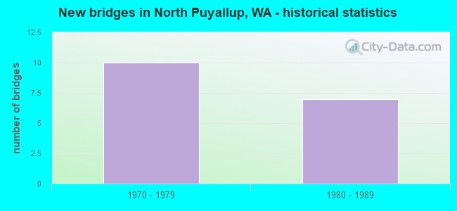
- New bridges - historical statistics
- 101970-1979
- 71980-1989


- Bridge Condition - Deck
- 10.0%Very good
- 50.0%Good
- 40.0%Satisfactory

- Bridge Condition - Superstructure
- 70.0%Good
- 20.0%Satisfactory
- 10.0%Fair
Find on map >> Show street view
Structure Number: 8746A, Location: 0.1 E JCT SR 167 (Lat: 47.201250, Lng: -122.254389), Route carried "on" structure: State highway 410, Year Built: 1971, Status: Open, Structure Length: 13.47m (44.19ft), Average Daily Traffic: 48,070 (year 2019), Truck Traffic: 7%, Average Future Daily Traffic: 69,605 (year 2039), Design Load: HS 20+Mod, Features Intersected: WHITE R (STUCK R)
Minimum Vertical Clearance: 30+ m (98+ ft), Kilometerpoint: 14.468, Lanes on structure: 6, Lanes under structure: 4, Base Highway Network: Yes, Owner: State Highway Agency, Approaching Roadway Width: 17.1m (56.1ft), Skew: 31 degrees, Material/Design: Prestressed concrete, Design/Construction: Stringer/Multi-beam, Number Of Spans In Main Unit: 1, Number Of Approach Spans: 2, Length of Maximum Span: 64.0m (210.0ft), Curb-To-Curb Width: 31.7m (104.0ft), Out-to-Out Width: 33.2m (108.9ft)
Condition: Deck: Good, Superstructure: Satisfactory, Substructure: Good, Channel: Very good, Operating Rating: 73.5 metric tons, Method Used To Determine Operating Rating: Load Factor (LF), Inventory Rating: 53.5 metric tons, Method Used To Determine Inventory Rating: Load Factor (LF), Structural Evaluation: Equal to present minimum criteria, Deck Geometry: Superior to present desirable criteria, Underclear: Equal to present minimum criteria, Waterway Adequacy: Equal to present desirable criteria, Approach Roadway Alignment: Equal to present desirable criteria, Length Of Structure Improvement: 13.47m (44.19ft), Designated Inspection Frequency: Every 24 months, Inspection Date: May 2021, Bridge Improvement Cost: $5,127,000, Roadway Improvement Cost: $1,025,000, Total Project Cost: $10,254,000 ( Estimate for 2014), Deck Structure Type: Concrete Cast-file-Place, Wearing Surface/Protective System: Wearing Surface: Latex Concrete
Find on map >> Show street view
Structure Number: 9075B, Location: 1.5 N JCT SR 161 (Lat: 47.200917, Lng: -122.261417), Route carried "on" structure: State highway 167, Year Built: 1973, Status: Open, Structure Length: 4.91m (16.11ft), Average Daily Traffic: 56,993 (year 2019), Truck Traffic: 9%, Average Future Daily Traffic: 82,525 (year 2039), Design Load: HS 20+Mod, Features Intersected: S-E RAMP
Minimum Vertical Clearance: 30+ m (98+ ft), Kilometerpoint: 10.960, Lanes on structure: 3, Lanes under structure: 1, Base Highway Network: Yes, Owner: State Highway Agency, Approaching Roadway Width: 16.5m (54.1ft), Skew: 2 degrees, Material/Design: Concrete continuous, Design/Construction: Slab, Number Of Spans In Main Unit: 3, Length of Maximum Span: 18.6m (61.0ft), Curb-To-Curb Width: 15.2m (49.9ft), Out-to-Out Width: 16.2m (53.1ft)
Condition: Deck: Good, Superstructure: Good, Substructure: Good, Operating Rating: 65.3 metric tons, Method Used To Determine Operating Rating: Load Factor (LF), Inventory Rating: 39.0 metric tons, Method Used To Determine Inventory Rating: Load Factor (LF), Structural Evaluation: Better than present minimum criteria, Deck Geometry: Meets minimum limits, Underclear: Superior to present desirable criteria, Approach Roadway Alignment: Equal to present desirable criteria, Length Of Structure Improvement: 4.91m (16.11ft), Designated Inspection Frequency: Every 48 months, Inspection Date: April 2021, Bridge Improvement Cost: $1,803,000, Roadway Improvement Cost: $361,000, Total Project Cost: $3,606,000 ( Estimate for 2014), Deck Structure Type: Concrete Cast-file-Place, Wearing Surface/Protective System: Wearing Surface: Monolithic Concrete
Find on map >> Show street view
Structure Number: 9075C, Location: 1.8 N JCT SR 161 (Lat: 47.202250, Lng: -122.256750), Route carried "on" structure: State highway 167, Year Built: 1971, Status: Open, Structure Length: 7.13m (23.39ft), Average Daily Traffic: 31,550 (year 2019), Truck Traffic: 9%, Average Future Daily Traffic: 45,684 (year 2039), Design Load: HS 20+Mod, Features Intersected: W-S RAMP
Minimum Vertical Clearance: 30+ m (98+ ft), Kilometerpoint: 11.346, Lanes on structure: 2, Lanes under structure: 2, Base Highway Network: Yes, Owner: State Highway Agency, Approaching Roadway Width: 13.1m (43.0ft), Skew: 3 degrees, Material/Design: Concrete continuous, Design/Construction: Box Beam or Girders - Multiple, Number Of Spans In Main Unit: 3, Length of Maximum Span: 32.0m (105.0ft), Curb-To-Curb Width: 12.2m (40.0ft), Out-to-Out Width: 13.7m (44.9ft)
Condition: Deck: Satisfactory, Superstructure: Satisfactory, Substructure: Good, Operating Rating: 87.1 metric tons, Method Used To Determine Operating Rating: Load Factor (LF), Inventory Rating: 51.7 metric tons, Method Used To Determine Inventory Rating: Load Factor (LF), Structural Evaluation: Equal to present minimum criteria, Deck Geometry: Better than present minimum criteria, Underclear: Equal to present minimum criteria, Approach Roadway Alignment: Equal to present desirable criteria, Length Of Structure Improvement: 7.13m (23.39ft), Designated Inspection Frequency: Every 48 months, Inspection Date: October 2018, Bridge Improvement Cost: $2,106,000, Roadway Improvement Cost: $421,000, Total Project Cost: $4,212,000 ( Estimate for 2014), Deck Structure Type: Concrete Cast-file-Place, Wearing Surface/Protective System: Wearing Surface: Monolithic Concrete
Find on map >> Show street view
Structure Number: 9075D, Location: 0.4 N JCT SR 410 (Lat: 47.203111, Lng: -122.253444), Route carried "on" structure: State highway 167, Year Built: 1973, Status: Open, Structure Length: 27.46m (90.09ft), Average Daily Traffic: 31,550 (year 2019), Truck Traffic: 9%, Average Future Daily Traffic: 45,684 (year 2039), Design Load: HS 20+Mod, Features Intersected: CITY STREETS & RR
Minimum Vertical Clearance: 30+ m (98+ ft), Kilometerpoint: 11.619, Lanes on structure: 3, Lanes under structure: 4, Base Highway Network: Yes, Owner: State Highway Agency, Approaching Roadway Width: 15.2m (49.9ft), Skew: 4 degrees, Material/Design: Prestressed concrete continuous, Design/Construction: Stringer/Multi-beam, Number Of Spans In Main Unit: 8, Length of Maximum Span: 41.1m (134.8ft), Curb-To-Curb Width: 15.4m (50.5ft), Out-to-Out Width: 19.8m (65.0ft)
Condition: Deck: Satisfactory, Superstructure: Good, Substructure: Good, Operating Rating: 59.9 metric tons, Method Used To Determine Operating Rating: Load Factor (LF), Inventory Rating: 36.3 metric tons, Method Used To Determine Inventory Rating: Load Factor (LF), Structural Evaluation: Better than present minimum criteria, Deck Geometry: Somewhat better than minimum adequacy, Underclear: Superior to present desirable criteria, Approach Roadway Alignment: Equal to present desirable criteria, Length Of Structure Improvement: 27.46m (90.09ft), Designated Inspection Frequency: Every 48 months, Inspection Date: October 2018, Bridge Improvement Cost: $9,370,000, Roadway Improvement Cost: $1,874,000, Total Project Cost: $18,741,000 ( Estimate for 2014), Deck Structure Type: Concrete Cast-file-Place, Wearing Surface/Protective System: Wearing Surface: Monolithic Concrete
Find on map >> Show street view
Structure Number: 9075E, Location: 2.7 E JCT SR 161 (Lat: 47.196583, Lng: -122.281722), Route carried "on" structure: City street , Year Built: 1972, Status: Open, Structure Length: 7.86m (25.79ft), Average Daily Traffic: 1,750 (year 2008), Truck Traffic: 8%, Average Future Daily Traffic: 2,289 (year 2036), Design Load: HS 20+Mod, Features Intersected: SR 512, Facility Carried by Structure: BENSTON DRIVE E
Minimum Vertical Clearance: 30+ m (98+ ft), Kilometerpoint: 2.961, Lanes on structure: 2, Lanes under structure: 4, Owner: State Highway Agency, Approaching Roadway Width: 9.1m (29.9ft), Skew: 1 degrees, Material/Design: Prestressed concrete continuous, Design/Construction: Stringer/Multi-beam, Number Of Spans In Main Unit: 4, Length of Maximum Span: 25.9m (85.0ft), Curb or Sidewalk Widths: Left: 0.9m (3.0ft), Right: 0.9m (3.0ft), Curb-To-Curb Width: 9.1m (29.9ft), Out-to-Out Width: 11.4m (37.4ft)
Condition: Deck: Good, Superstructure: Good, Substructure: Good, Operating Rating: 27.5 metric tons, Method Used To Determine Operating Rating: Load and Resistance Factor Rating (LRFR) rating reported by rating factor(RF) method using HL-93 loadings, Inventory Rating: 21.4 metric tons, Method Used To Determine Inventory Rating: Load and Resistance Factor Rating (LRFR) rating reported by rating factor(RF) method using HL-93 loadings, Structural Evaluation: Somewhat better than minimum adequacy, Deck Geometry: Somewhat better than minimum adequacy, Underclear: Equal to present minimum criteria, Approach Roadway Alignment: Equal to present minimum criteria, Length Of Structure Improvement: 7.86m (25.79ft), Designated Inspection Frequency: Every 48 months, Inspection Date: June 2018, Bridge Improvement Cost: $1,651,000, Roadway Improvement Cost: $330,000, Total Project Cost: $3,302,000 ( Estimate for 2014), Deck Structure Type: Concrete Cast-file-Place, Wearing Surface/Protective System: Wearing Surface: Monolithic Concrete
Find on map >> Show street view
Structure Number: 9831A, Location: 3.2 E JCT SR 161 (Lat: 47.202111, Lng: -122.279028), Route carried "on" structure: State highway 512, Year Built: 1975, Status: Open, Structure Length: 10.27m (33.69ft), Average Daily Traffic: 22,948 (year 2019), Truck Traffic: 8%, Average Future Daily Traffic: 33,228 (year 2039), Design Load: HS 20+Mod, Features Intersected: SR 167
Minimum Vertical Clearance: 30+ m (98+ ft), Kilometerpoint: 19.296, Lanes on structure: 2, Lanes under structure: 5, Base Highway Network: Yes, Owner: State Highway Agency, Approaching Roadway Width: 11.6m (38.1ft), Skew: 1 degrees, Material/Design: Prestressed concrete continuous, Design/Construction: Stringer/Multi-beam, Number Of Spans In Main Unit: 4, Length of Maximum Span: 37.8m (124.0ft), Curb-To-Curb Width: 11.6m (38.1ft), Out-to-Out Width: 12.5m (41.0ft)
Condition: Deck: Very good, Superstructure: Good, Substructure: Good, Operating Rating: 18.5 metric tons, Method Used To Determine Operating Rating: Load and Resistance Factor Rating (LRFR) rating reported by rating factor(RF) method using HL-93 loadings, Inventory Rating: 14.3 metric tons, Method Used To Determine Inventory Rating: Load and Resistance Factor Rating (LRFR) rating reported by rating factor(RF) method using HL-93 loadings, Structural Evaluation: High priority of corrective action, Deck Geometry: Equal to present minimum criteria, Underclear: Superior to present desirable criteria, Approach Roadway Alignment: Equal to present desirable criteria, Length Of Structure Improvement: 10.27m (33.69ft), Designated Inspection Frequency: Every 24 months, Inspection Date: April 2021, Bridge Improvement Cost: $2,696,000, Roadway Improvement Cost: $539,000, Total Project Cost: $5,392,000 ( Estimate for 2014), Deck Structure Type: Concrete Cast-file-Place, Wearing Surface/Protective System: Wearing Surface: Bituminous
Find on map >> Show street view
Structure Number: 13042A, Location: 1.5 N JCT SR 161 (Lat: 47.201222, Lng: -122.261581), Route carried "on" structure: State highway 167, Year Built: 1987, Status: Open, Structure Length: 4.57m (14.99ft), Average Daily Traffic: 56,993 (year 2019), Truck Traffic: 9%, Average Future Daily Traffic: 82,525 (year 2039), Design Load: HS 20+Mod, Features Intersected: S-E RAMP
Minimum Vertical Clearance: 30+ m (98+ ft), Kilometerpoint: 10.960, Lanes on structure: 2, Lanes under structure: 1, Base Highway Network: Yes, Owner: State Highway Agency, Approaching Roadway Width: 12.2m (40.0ft), Skew: 1 degrees, Material/Design: Concrete continuous, Design/Construction: Slab, Number Of Spans In Main Unit: 3, Length of Maximum Span: 18.0m (59.1ft), Curb-To-Curb Width: 12.2m (40.0ft), Out-to-Out Width: 12.6m (41.3ft)
Condition: Deck: Good, Superstructure: Good, Substructure: Good, Operating Rating: 65.3 metric tons, Method Used To Determine Operating Rating: Load Factor (LF), Inventory Rating: 39.0 metric tons, Method Used To Determine Inventory Rating: Load Factor (LF), Structural Evaluation: Better than present minimum criteria, Deck Geometry: Better than present minimum criteria, Underclear: Equal to present minimum criteria, Approach Roadway Alignment: Equal to present desirable criteria, Length Of Structure Improvement: 4.57m (14.99ft), Designated Inspection Frequency: Every 48 months, Inspection Date: April 2021, Bridge Improvement Cost: $1,260,000, Roadway Improvement Cost: $252,000, Total Project Cost: $2,520,000 ( Estimate for 2014), Deck Structure Type: Concrete Cast-file-Place, Wearing Surface/Protective System: Wearing Surface: Monolithic Concrete, Deck Protection: Epoxy Coated Reinforcing
Find on map >> Show street view
Structure Number: 13042B, Location: 1.8 N JCT SR 161 (Lat: 47.202417, Lng: -122.257333), Route carried "on" structure: State highway 167, Year Built: 1988, Status: Open, Structure Length: 8.23m (27.00ft), Average Daily Traffic: 31,550 (year 2019), Truck Traffic: 9%, Average Future Daily Traffic: 45,684 (year 2039), Design Load: HS 20+Mod, Features Intersected: W-S RAMP
Minimum Vertical Clearance: 30+ m (98+ ft), Kilometerpoint: 11.314, Lanes on structure: 3, Lanes under structure: 2, Base Highway Network: Yes, Owner: State Highway Agency, Approaching Roadway Width: 15.2m (49.9ft), Skew: 4 degrees, Material/Design: Concrete continuous, Design/Construction: Box Beam or Girders - Multiple, Number Of Spans In Main Unit: 3, Length of Maximum Span: 36.6m (120.1ft), Curb-To-Curb Width: 15.3m (50.2ft), Out-to-Out Width: 15.8m (51.8ft)
Condition: Deck: Satisfactory, Superstructure: Good, Substructure: Good, Operating Rating: 89.8 metric tons, Method Used To Determine Operating Rating: Load Factor (LF), Inventory Rating: 87.1 metric tons, Method Used To Determine Inventory Rating: Load Factor (LF), Structural Evaluation: Better than present minimum criteria, Deck Geometry: Meets minimum limits, Underclear: Equal to present minimum criteria, Approach Roadway Alignment: Equal to present desirable criteria, Length Of Structure Improvement: 8.23m (27.00ft), Designated Inspection Frequency: Every 48 months, Inspection Date: October 2018, Bridge Improvement Cost: $2,808,000, Roadway Improvement Cost: $562,000, Total Project Cost: $5,616,000 ( Estimate for 2014), Deck Structure Type: Concrete Cast-file-Place, Wearing Surface/Protective System: Wearing Surface: Monolithic Concrete, Deck Protection: Epoxy Coated Reinforcing
Find on map >> Show street view
Structure Number: 13042C, Location: 0.4 N JCT SR 410 (Lat: 47.203250, Lng: -122.254417), Route carried "on" structure: State highway 167, Year Built: 1987, Status: Open, Structure Length: 30.85m (101.21ft), Average Daily Traffic: 31,550 (year 2019), Truck Traffic: 9%, Average Future Daily Traffic: 45,684 (year 2039), Design Load: HS 20+Mod, Features Intersected: CITY STREETS & RR
Minimum Vertical Clearance: 30+ m (98+ ft), Kilometerpoint: 11.571, Lanes on structure: 2, Lanes under structure: 4, Base Highway Network: Yes, Owner: State Highway Agency, Approaching Roadway Width: 11.6m (38.1ft), Skew: 5 degrees, Material/Design: Prestressed concrete continuous, Design/Construction: Stringer/Multi-beam, Number Of Spans In Main Unit: 9, Length of Maximum Span: 34.7m (113.8ft), Curb-To-Curb Width: 11.6m (38.1ft), Out-to-Out Width: 12.6m (41.3ft)
Condition: Deck: Satisfactory, Superstructure: Fair, Substructure: Good, Operating Rating: 23.7 metric tons, Method Used To Determine Operating Rating: Load and Resistance Factor Rating (LRFR) rating reported by rating factor(RF) method using HL-93 loadings, Inventory Rating: 18.5 metric tons, Method Used To Determine Inventory Rating: Load and Resistance Factor Rating (LRFR) rating reported by rating factor(RF) method using HL-93 loadings, Structural Evaluation: Meets minimum limits, Deck Geometry: Equal to present minimum criteria, Underclear: Equal to present minimum criteria, Approach Roadway Alignment: Equal to present desirable criteria, Length Of Structure Improvement: 30.85m (101.21ft), Designated Inspection Frequency: Every 24 months, Inspection Date: November 2020, Bridge Improvement Cost: $8,096,000, Roadway Improvement Cost: $1,619,000, Total Project Cost: $16,192,000 ( Estimate for 2014), Deck Structure Type: Concrete Cast-file-Place, Wearing Surface/Protective System: Wearing Surface: Monolithic Concrete, Deck Protection: Epoxy Coated Reinforcing
Find on map >> Show street view
Structure Number: 13183A, Location: 3.2 E JCT SR 161 (Lat: 47.202083, Lng: -122.278778), Route carried "on" structure: State highway 512, Year Built: 1987, Status: Open, Structure Length: 10.30m (33.79ft), Average Daily Traffic: 22,948 (year 2019), Truck Traffic: 8%, Average Future Daily Traffic: 33,228 (year 2039), Design Load: HS 20+Mod, Features Intersected: SR 167
Minimum Vertical Clearance: 30+ m (98+ ft), Kilometerpoint: 19.296, Lanes on structure: 1, Lanes under structure: 5, Base Highway Network: Yes, Owner: State Highway Agency, Approaching Roadway Width: 8.2m (26.9ft), Skew: 2 degrees, Material/Design: Prestressed concrete continuous, Design/Construction: Stringer/Multi-beam, Number Of Spans In Main Unit: 4, Length of Maximum Span: 36.6m (120.1ft), Curb-To-Curb Width: 8.1m (26.6ft), Out-to-Out Width: 8.6m (28.2ft)
Condition: Deck: Good, Superstructure: Good, Substructure: Good, Operating Rating: 81.6 metric tons, Method Used To Determine Operating Rating: Load Factor (LF), Inventory Rating: 48.1 metric tons, Method Used To Determine Inventory Rating: Load Factor (LF), Structural Evaluation: Better than present minimum criteria, Deck Geometry: High priority of corrective action, Underclear: Better than present minimum criteria, Approach Roadway Alignment: Equal to present desirable criteria, Length Of Structure Improvement: 10.30m (33.79ft), Designated Inspection Frequency: Every 24 months, Inspection Date: April 2021, Bridge Improvement Cost: $1,960,000, Roadway Improvement Cost: $392,000, Total Project Cost: $3,921,000 ( Estimate for 2014), Deck Structure Type: Concrete Cast-file-Place, Wearing Surface/Protective System: Wearing Surface: Latex Concrete, Deck Protection: Epoxy Coated Reinforcing
Find on map >> Show street view
Structure Number: 9075B, Location: 0.7 N JCT SR 512 (Lat: 47.200917, Lng: -122.261417), Route carried "under" structure: Ramp State highway 167, Year Built: 1973, Structure Length: 0. m, Average Daily Traffic: 14,249 (year 2019), Truck Traffic: 8%, Features Intersected: S-E RAMP
Minimum Vertical Clearance: 5.56m (18.24ft), Kilometerpoint: 0.547, Lanes on structure: 3, Lanes under structure: 1, Material/Design: Concrete continuous, Design/Construction: Slab, Length of Maximum Span: 18.6m (61.0ft)
Find on map >> Show street view
Structure Number: 9075C, Location: JCT SR 167 (Lat: 47.202250, Lng: -122.256750), Route carried "under" structure: State highway 410, Year Built: 1971, Structure Length: 0. m, Average Daily Traffic: 24,035 (year 2019), Truck Traffic: 7%, Features Intersected: W-S RAMP, Facility Carried by Structure: SR 167
Minimum Vertical Clearance: 5.41m (17.75ft), Kilometerpoint: 14.275, Lanes on structure: 2, Lanes under structure: 2, Material/Design: Concrete continuous, Design/Construction: Box Beam or Girders - Multiple, Length of Maximum Span: 32.0m (105.0ft)
Find on map >> Show street view
Structure Number: 9075E, Location: 2.7 E JCT SR 161 (Lat: 47.196583, Lng: -122.281722), Route carried "under" structure: State highway 512, Year Built: 1972, Structure Length: 0. m, Average Daily Traffic: 98,026 (year 2019), Truck Traffic: 8%, Features Intersected: SR 512, Facility Carried by Structure: BENSTON DRIVE E
Minimum Vertical Clearance: 6.07m (19.91ft), Kilometerpoint: 18.636, Lanes on structure: 2, Lanes under structure: 4, Material/Design: Prestressed concrete continuous, Design/Construction: Stringer/Multi-beam, Length of Maximum Span: 25.9m (85.0ft)
Find on map >> Show street view
Structure Number: 9831A, Location: 0.7 N JCT SR 161 (Lat: 47.202111, Lng: -122.279028), Route carried "under" structure: State highway 167, Year Built: 1975, Structure Length: 0. m, Average Daily Traffic: 29,188 (year 2019), Truck Traffic: 12%, Features Intersected: SR 167, Facility Carried by Structure: SR 512
Minimum Vertical Clearance: 6.07m (19.91ft), Kilometerpoint: 9.624, Lanes on structure: 2, Lanes under structure: 5, Material/Design: Prestressed concrete continuous, Design/Construction: Stringer/Multi-beam, Length of Maximum Span: 37.8m (124.0ft)
Find on map >> Show street view
Structure Number: 13042A, Location: 0.7 N JCT SR 512 (Lat: 47.201222, Lng: -122.261581), Route carried "under" structure: State highway 167, Year Built: 1987, Structure Length: 0. m, Average Daily Traffic: 14,249 (year 2019), Truck Traffic: 8%, Features Intersected: S-E RAMP
Minimum Vertical Clearance: 5.28m (17.32ft), Kilometerpoint: 0.499, Lanes on structure: 2, Lanes under structure: 1, Material/Design: Concrete continuous, Design/Construction: Slab, Length of Maximum Span: 18.0m (59.1ft)
Find on map >> Show street view
Structure Number: 13042B, Location: JCT SR 167 (Lat: 47.202417, Lng: -122.257333), Route carried "under" structure: State highway 410, Year Built: 1988, Structure Length: 0. m, Average Daily Traffic: 24,035 (year 2019), Truck Traffic: 7%, Features Intersected: W-S RAMP, Facility Carried by Structure: SR 167
Minimum Vertical Clearance: 5.89m (19.32ft), Kilometerpoint: 14.227, Lanes on structure: 3, Lanes under structure: 2, Material/Design: Concrete continuous, Design/Construction: Box Beam or Girders - Multiple, Length of Maximum Span: 36.6m (120.1ft)
Find on map >> Show street view
Structure Number: 13183A, Location: 0.7 N JCT SR 161 (Lat: 47.202083, Lng: -122.278778), Route carried "under" structure: State highway 167, Year Built: 1987, Structure Length: 0. m, Average Daily Traffic: 29,188 (year 2019), Truck Traffic: 12%, Features Intersected: SR 167, Facility Carried by Structure: SR 512
Minimum Vertical Clearance: 5.31m (17.42ft), Kilometerpoint: 9.656, Lanes on structure: 1, Lanes under structure: 5, Material/Design: Prestressed concrete continuous, Design/Construction: Stringer/Multi-beam, Length of Maximum Span: 36.6m (120.1ft)