Bridge Statistics for North Salt Lake, Utah (UT)
Condition, Traffic, Stress, Structural Evaluation, Project Costs
- National Bridge Inventory (NBI) Statistics
- 30Number of bridges
- 384ft / 117mTotal length
- 1,352,959Total average daily traffic
- 186,088Total average daily truck traffic
- National Bridge Inventory (NBI) Registered Bridges for North Salt Lake
- No street view available for this location
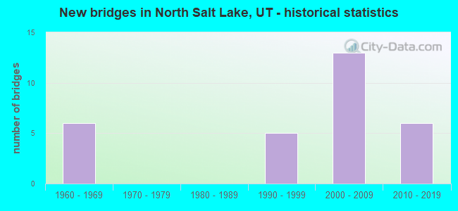
- New bridges - historical statistics
- 61960-1969
- 51990-1999
- 132000-2009
- 62010-2019
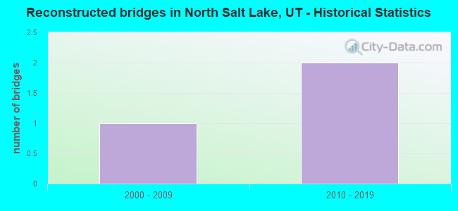
- Reconstructed bridges - Historical Statistics
- 12000-2009
- 22010-2019
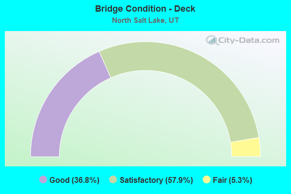
- Bridge Condition - Deck
- 36.8%Good
- 57.9%Satisfactory
- 5.3%Fair
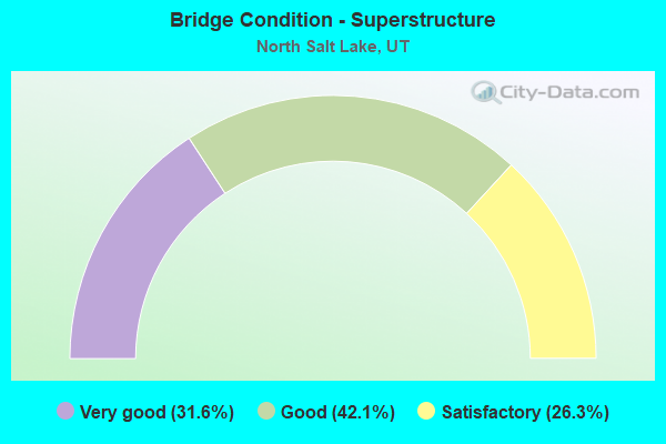
- Bridge Condition - Superstructure
- 31.6%Very good
- 42.1%Good
- 26.3%Satisfactory
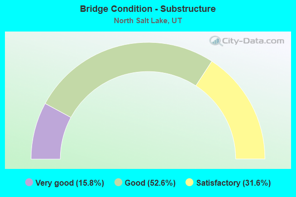
- Bridge Condition - Substructure
- 15.8%Very good
- 52.6%Good
- 31.6%Satisfactory
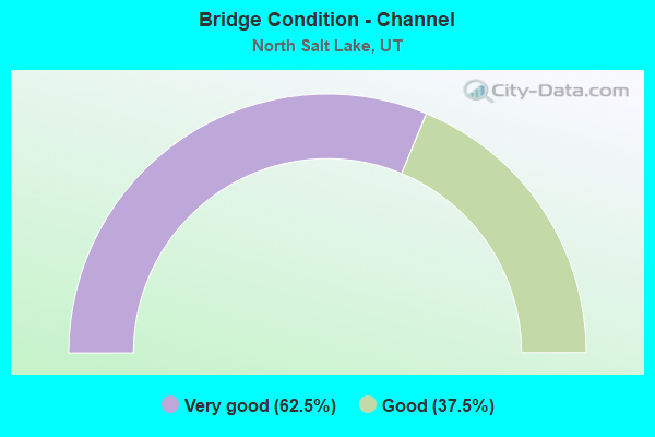
- Bridge Condition - Channel
- 62.5%Very good
- 37.5%Good
Find on map >> Show street view
Structure Number: 11002F, Location: 2100 W.CENTER ST.in NSL. (Lat: 40.841961, Lng: -111.951422), Route carried "on" structure: City street 1392, Year Built: 1995, Status: Open, Structure Length: 2.71m (8.89ft), Average Daily Traffic: 4,290 (year 2020), Average Future Daily Traffic: 5,363 (year 2040), Design Load: HS 20+Mod, Features Intersected: JORDAN RIVER, Facility Carried by Structure: CENTER STREET
Minimum Vertical Clearance: 30+ m (98+ ft), Kilometerpoint: 0.302, Lanes on structure: 2, Owner: City or Municipal Highway Agency, Approaching Roadway Width: 10.4m (34.1ft), Material/Design: Prestressed concrete, Design/Construction: Stringer/Multi-beam, Number Of Spans In Main Unit: 1, Length of Maximum Span: 26.7m (87.6ft), Curb-To-Curb Width: 10.4m (34.1ft), Out-to-Out Width: 11.3m (37.1ft)
Condition: Deck: Satisfactory, Superstructure: Very good, Substructure: Very good, Channel: Good, Operating Rating: 32.4 metric tons, Method Used To Determine Operating Rating: Load and Resistance Factor Rating (LRFR) rating reported by rating factor(RF) method using HL-93 loadings, Inventory Rating: 19.8 metric tons, Method Used To Determine Inventory Rating: Load and Resistance Factor Rating (LRFR) rating reported by rating factor(RF) method using HL-93 loadings, Structural Evaluation: Somewhat better than minimum adequacy, Deck Geometry: Somewhat better than minimum adequacy, Waterway Adequacy: Equal to present minimum criteria, Approach Roadway Alignment: Equal to present desirable criteria, Designated Inspection Frequency: Every 24 months, Inspection Date: March 2020, Deck Structure Type: Concrete Cast-file-Place, Wearing Surface/Protective System: Wearing Surface: Monolithic Concrete, Deck Protection: Epoxy Coated Reinforcing
Find on map >> Show street view
Structure Number: 11029E, Location: 2000 W. Center St. in NSL (Lat: 40.841497, Lng: -111.941647), Route carried "on" structure: City street 1392, Year Built: 2008, Status: Open, Structure Length: 0.83m (2.72ft), Average Daily Traffic: 4,290 (year 2020), Average Future Daily Traffic: 5,363 (year 2040), Design Load: HS 25 or greater, Features Intersected: LEGACY PARKWAY TRAIL, Facility Carried by Structure: CENTER ST. IN NSL.
Minimum Vertical Clearance: 30+ m (98+ ft), Kilometerpoint: 1.133, Lanes on structure: 2, Owner: City or Municipal Highway Agency, Approaching Roadway Width: 11.6m (38.1ft), Material/Design: Concrete, Design/Construction: Culvert, Number Of Spans In Main Unit: 1, Length of Maximum Span: 7.3m (24.0ft), Curb or Sidewalk Widths: Left: 3.0m (9.8ft), Right: 0.0m
Condition: Culverts: Satisfactory, Operating Rating: 32.4 metric tons, Method Used To Determine Operating Rating: Load and Resistance Factor Rating (LRFR) rating reported by rating factor(RF) method using HL-93 loadings, Inventory Rating: 19.8 metric tons, Method Used To Determine Inventory Rating: Load and Resistance Factor Rating (LRFR) rating reported by rating factor(RF) method using HL-93 loadings, Structural Evaluation: Somewhat better than minimum adequacy, Approach Roadway Alignment: Better than present minimum criteria, Designated Inspection Frequency: Every 24 months, Inspection Date: March 2020
Find on map >> Show street view
Structure Number: 35132C, Location: 2100 W. CENTER ST., NSL (Lat: 40.841950, Lng: -111.953708), Route carried "on" structure: County highway 1392, Year Built: 2004, Status: Open, Structure Length: 1.90m (6.23ft), Average Daily Traffic: 4,290 (year 2020), Average Future Daily Traffic: 5,363 (year 2040), Design Load: HS 20+Mod, Features Intersected: DRAINAGE CANAL, Facility Carried by Structure: NO. SL. CENTER ST.
Minimum Vertical Clearance: 30+ m (98+ ft), Kilometerpoint: 0.109, Lanes on structure: 2, Owner: County Highway Agency, Approaching Roadway Width: 10.4m (34.1ft), Skew: 4 degrees, Material/Design: Steel, Design/Construction: Stringer/Multi-beam, Number Of Spans In Main Unit: 1, Length of Maximum Span: 18.3m (60.0ft), Curb-To-Curb Width: 10.4m (34.1ft), Out-to-Out Width: 10.4m (34.1ft)
Condition: Deck: Fair, Superstructure: Satisfactory, Substructure: Good, Channel: Very good, Operating Rating: 41.1 metric tons, Method Used To Determine Operating Rating: Load and Resistance Factor Rating (LRFR) rating reported by rating factor(RF) method using HL-93 loadings, Inventory Rating: 37.3 metric tons, Method Used To Determine Inventory Rating: Load Factor (LF) rating reported by rating factor (RF) method using MS18 loading, Structural Evaluation: Equal to present minimum criteria, Deck Geometry: Somewhat better than minimum adequacy, Waterway Adequacy: Better than present minimum criteria, Approach Roadway Alignment: Equal to present desirable criteria, Designated Inspection Frequency: Every 24 months, Inspection Date: December 2021, Deck Structure Type: Corrugated Steel, Wearing Surface/Protective System: Wearing Surface: Bituminous
Find on map >> Show street view
Structure Number: C 512, Location: Redwood Rd over I-215 NSL (Lat: 40.833622, Lng: -111.936092), Route carried "on" structure: State highway 68, Year Built: 1969, Year Reconstructed: 2006, Status: Open, Structure Length: 7.05m (23.13ft), Average Daily Traffic: 12,181 (year 2020), Truck Traffic: 23%, Average Future Daily Traffic: 15,226 (year 2040), Design Load: HS 20+Mod, Features Intersected: I-215 (SR-215) EBL / WBL
Minimum Vertical Clearance: 30+ m (98+ ft), Kilometerpoint: 102.772, Lanes on structure: 2, Lanes under structure: 4, Owner: State Highway Agency, Approaching Roadway Width: 13.7m (44.9ft), Skew: 1 degrees, Material/Design: Steel continuous, Design/Construction: Stringer/Multi-beam, Number Of Spans In Main Unit: 2, Length of Maximum Span: 34.5m (113.2ft), Curb-To-Curb Width: 13.7m (44.9ft), Out-to-Out Width: 14.7m (48.2ft)
Condition: Deck: Satisfactory, Superstructure: Satisfactory, Substructure: Satisfactory, Operating Rating: 34.0 metric tons, Method Used To Determine Operating Rating: Load and Resistance Factor Rating (LRFR) rating reported by rating factor(RF) method using HL-93 loadings, Inventory Rating: 33.7 metric tons, Method Used To Determine Inventory Rating: Load Factor (LF) rating reported by rating factor (RF) method using MS18 loading, Structural Evaluation: Equal to present minimum criteria, Deck Geometry: Superior to present desirable criteria, Underclear: Equal to present minimum criteria, Approach Roadway Alignment: Equal to present minimum criteria, Designated Inspection Frequency: Every 24 months, Inspection Date: June 2021, Deck Structure Type: Concrete Cast-file-Place, Wearing Surface/Protective System: Membrane: Epoxy
Find on map >> Show street view
Structure Number: C 803, Location: 0.7 Mi.NO. CENTER ST.-NSL (Lat: 40.850239, Lng: -111.912022), Route carried "on" structure: Interstate 15, Year Built: 1997, Status: Open, Structure Length: 4.68m (15.35ft), Average Daily Traffic: 146,910 (year 2020), Truck Traffic: 12%, Average Future Daily Traffic: 183,638 (year 2040), Design Load: HS 20+Mod, Features Intersected: 1100 WEST ST. (MAIN ST.)
Minimum Vertical Clearance: 30+ m (98+ ft), Kilometerpoint: 506.361, Lanes on structure: 10, Lanes under structure: 2, Base Highway Network: Yes, Owner: State Highway Agency, Approaching Roadway Width: 51.3m (168.3ft), Skew: 35 degrees, Material/Design: Steel, Design/Construction: Stringer/Multi-beam, Number Of Spans In Main Unit: 1, Length of Maximum Span: 45.0m (147.6ft), Curb-To-Curb Width: 51.3m (168.3ft), Out-to-Out Width: 53.3m (174.9ft)
Condition: Deck: Satisfactory, Superstructure: Good, Substructure: Good, Operating Rating: 54.8 metric tons, Method Used To Determine Operating Rating: Load and Resistance Factor Rating (LRFR) rating reported by rating factor(RF) method using HL-93 loadings, Inventory Rating: 38.6 metric tons, Method Used To Determine Inventory Rating: Load and Resistance Factor Rating (LRFR) rating reported by rating factor(RF) method using HL-93 loadings, Structural Evaluation: Better than present minimum criteria, Deck Geometry: Superior to present desirable criteria, Underclear: Equal to present minimum criteria, Approach Roadway Alignment: Equal to present desirable criteria, Designated Inspection Frequency: Every 24 months, Inspection Date: June 2021, Deck Structure Type: Concrete Cast-file-Place, Wearing Surface/Protective System: Wearing Surface: Monolithic Concrete, Deck Protection: Epoxy Coated Reinforcing
Find on map >> Show street view
Structure Number: C 804, Location: WEST SIDE OF NO.SALT LAKE (Lat: 40.841708, Lng: -111.915233), Route carried "on" structure: Interstate 15, Year Built: 1997, Status: Open, Structure Length: 3.27m (10.73ft), Average Daily Traffic: 146,910 (year 2020), Truck Traffic: 12%, Average Future Daily Traffic: 183,638 (year 2040), Design Load: HS 20+Mod, Features Intersected: CENTER ST. (CUDAHY LN.)
Minimum Vertical Clearance: 30+ m (98+ ft), Kilometerpoint: 505.358, Lanes on structure: 10, Lanes under structure: 2, Base Highway Network: Yes, Owner: State Highway Agency, Approaching Roadway Width: 48.9m (160.4ft), Skew: 30 degrees, Material/Design: Steel continuous, Design/Construction: Stringer/Multi-beam, Number Of Spans In Main Unit: 3, Length of Maximum Span: 23.3m (76.4ft), Curb-To-Curb Width: 48.9m (160.4ft), Out-to-Out Width: 53.3m (174.9ft)
Condition: Deck: Good, Superstructure: Good, Substructure: Good, Operating Rating: 56.1 metric tons, Method Used To Determine Operating Rating: Load and Resistance Factor Rating (LRFR) rating reported by rating factor(RF) method using HL-93 loadings, Inventory Rating: 45.7 metric tons, Method Used To Determine Inventory Rating: Load Factor (LF) rating reported by rating factor (RF) method using MS18 loading, Structural Evaluation: Better than present minimum criteria, Deck Geometry: Superior to present desirable criteria, Underclear: Better than present minimum criteria, Approach Roadway Alignment: Equal to present desirable criteria, Designated Inspection Frequency: Every 24 months, Inspection Date: June 2021, Deck Structure Type: Concrete Cast-file-Place, Wearing Surface/Protective System: Wearing Surface: Monolithic Concrete, Deck Protection: Epoxy Coated Reinforcing
Find on map >> Show street view
Structure Number: E2487, Location: No.of I-215-Legacy Intchg (Lat: 40.834725, Lng: -111.941608), Route carried "on" structure: State highway 67, Year Built: 2006, Status: Open, Structure Length: 1.17m (3.84ft), Average Daily Traffic: 19,728 (year 2020), Truck Traffic: 18%, Average Future Daily Traffic: 24,660 (year 2040), Design Load: HS 25 or greater, Features Intersected: SLC. DRAINAGE CANAL
Minimum Vertical Clearance: 30+ m (98+ ft), Kilometerpoint: 0.911, Lanes on structure: 4, Owner: State Highway Agency, Approaching Roadway Width: 26.2m (86.0ft), Skew: 1 degrees, Material/Design: Concrete continuous, Design/Construction: Culvert, Number Of Spans In Main Unit: 3, Length of Maximum Span: 3.7m (12.1ft), Curb-To-Curb Width: 13.1m (43.0ft), Out-to-Out Width: 69.6m (228.3ft)
Condition: Channel: Very good, Culverts: Satisfactory, Operating Rating: 97.2 metric tons, Method Used To Determine Operating Rating: Load and Resistance Factor Rating (LRFR) rating reported by rating factor(RF) method using HL-93 loadings, Inventory Rating: 96.9 metric tons, Method Used To Determine Inventory Rating: Load and Resistance Factor Rating (LRFR) rating reported by rating factor(RF) method using HL-93 loadings, Structural Evaluation: Equal to present minimum criteria, Deck Geometry: High priority of replacement, Waterway Adequacy: Equal to present desirable criteria, Approach Roadway Alignment: Equal to present desirable criteria, Designated Inspection Frequency: Every 24 months, Inspection Date: June 2021
Find on map >> Show street view
Structure Number: F 717, Location: W.Center St.inN.Salt Lake (Lat: 40.841494, Lng: -111.943150), Route carried "on" structure: City street 1392, Year Built: 2008, Status: Open, Structure Length: 5.79m (19.00ft), Average Daily Traffic: 4,290 (year 2020), Average Future Daily Traffic: 5,363 (year 2040), Design Load: HL 93, Features Intersected: SR-67,LEGACY PARKWAY, Facility Carried by Structure: CENTER ST. in NSL.
Minimum Vertical Clearance: 30+ m (98+ ft), Kilometerpoint: 1.006, Lanes on structure: 2, Lanes under structure: 4, Owner: State Highway Agency, Approaching Roadway Width: 12.2m (40.0ft), Skew: 1 degrees, Material/Design: Prestressed concrete continuous, Design/Construction: Stringer/Multi-beam, Number Of Spans In Main Unit: 2, Length of Maximum Span: 28.3m (92.8ft), Curb or Sidewalk Widths: Left: 3.0m (9.8ft), Right: 0.0m, Curb-To-Curb Width: 12.2m (40.0ft), Out-to-Out Width: 16.5m (54.1ft)
Condition: Deck: Satisfactory, Superstructure: Very good, Substructure: Good, Operating Rating: 47.6 metric tons, Method Used To Determine Operating Rating: Load and Resistance Factor Rating (LRFR) rating reported by rating factor(RF) method using HL-93 loadings, Inventory Rating: 30.1 metric tons, Method Used To Determine Inventory Rating: Load and Resistance Factor Rating (LRFR) rating reported by rating factor(RF) method using HL-93 loadings, Structural Evaluation: Better than present minimum criteria, Deck Geometry: Equal to present minimum criteria, Underclear: Better than present minimum criteria, Approach Roadway Alignment: Equal to present desirable criteria, Designated Inspection Frequency: Every 24 months, Inspection Date: June 2021, Deck Structure Type: Concrete Cast-file-Place, Wearing Surface/Protective System: Wearing Surface: Epoxy Overlay, Deck Protection: Epoxy Coated Reinforcing
Find on map >> Show street view
Structure Number: 1C1024, Location: 2600 SO.INTCHG.in NO. SLC (Lat: 40.861272, Lng: -111.902133), Route carried "on" structure: Interstate 15, Year Built: 2015, Status: Open, Structure Length: 4.70m (15.42ft), Average Daily Traffic: 146,910 (year 2020), Truck Traffic: 12%, Average Future Daily Traffic: 183,638 (year 2040), Design Load: HS 20+Mod, Features Intersected: SR-93, 2600 SOUTH in NSL
Minimum Vertical Clearance: 30+ m (98+ ft), Kilometerpoint: 507.843, Lanes on structure: 5, Lanes under structure: 7, Base Highway Network: Yes, Owner: State Highway Agency, Approaching Roadway Width: 24.4m (80.1ft), Skew: 30 degrees, Material/Design: Steel, Design/Construction: Stringer/Multi-beam, Number Of Spans In Main Unit: 1, Length of Maximum Span: 45.8m (150.3ft), Curb-To-Curb Width: 24.4m (80.1ft), Out-to-Out Width: 25.3m (83.0ft)
Condition: Deck: Good, Superstructure: Very good, Substructure: Good, Operating Rating: 48.9 metric tons, Method Used To Determine Operating Rating: Load and Resistance Factor Rating (LRFR) rating reported by rating factor(RF) method using HL-93 loadings, Inventory Rating: 34.3 metric tons, Method Used To Determine Inventory Rating: Load and Resistance Factor Rating (LRFR) rating reported by rating factor(RF) method using HL-93 loadings, Structural Evaluation: Better than present minimum criteria, Deck Geometry: Equal to present minimum criteria, Underclear: Meets minimum limits, Approach Roadway Alignment: Superior to present desirable criteria, Designated Inspection Frequency: Every 24 months, Inspection Date: June 2021, Deck Structure Type: Concrete Precast Panels, Wearing Surface/Protective System: Wearing Surface: Epoxy Overlay, Deck Protection: Epoxy Coated Reinforcing
Find on map >> Show street view
Structure Number: 1E2569, Location: Just No. of Jordan River (Lat: 40.832200, Lng: -111.942981), Route carried "on" structure: State highway 215, Year Built: 2008, Status: Open, Structure Length: 0.69m (2.26ft), Average Daily Traffic: 36,543 (year 2020), Truck Traffic: 17%, Average Future Daily Traffic: 45,679 (year 2040), Design Load: HL 93, Features Intersected: LEGACY PARKWAY TRAIL
Minimum Vertical Clearance: 30+ m (98+ ft), Kilometerpoint: 43.522, Lanes on structure: 3, Base Highway Network: Yes, Owner: State Highway Agency, Approaching Roadway Width: 18.9m (62.0ft), Material/Design: Concrete, Design/Construction: Culvert, Number Of Spans In Main Unit: 1, Length of Maximum Span: 6.1m (20.0ft), Curb-To-Curb Width: 18.9m (62.0ft), Out-to-Out Width: 19.7m (64.6ft)
Condition: Culverts: Satisfactory, Operating Rating: 47.0 metric tons, Method Used To Determine Operating Rating: Load and Resistance Factor Rating (LRFR) rating reported by rating factor(RF) method using HL-93 loadings, Inventory Rating: 38.9 metric tons, Method Used To Determine Inventory Rating: Load and Resistance Factor Rating (LRFR) rating reported by rating factor(RF) method using HL-93 loadings, Structural Evaluation: Equal to present minimum criteria, Deck Geometry: Superior to present desirable criteria, Approach Roadway Alignment: Equal to present desirable criteria, Designated Inspection Frequency: Every 24 months, Inspection Date: June 2021
Find on map >> Show street view
Structure Number: 1F 644, Location: At Legacy Pkwy.,I-215 Int (Lat: 40.831667, Lng: -111.944222), Route carried "on" structure: State highway 67, Year Built: 2008, Status: Open, Structure Length: 3.68m (12.07ft), Average Daily Traffic: 19,728 (year 2020), Truck Traffic: 18%, Average Future Daily Traffic: 24,660 (year 2040), Design Load: HS 25 or greater, Features Intersected: JORDAN RIVER
Minimum Vertical Clearance: 30+ m (98+ ft), Kilometerpoint: 0.503, Lanes on structure: 2, Owner: State Highway Agency, Approaching Roadway Width: 12.6m (41.3ft), Skew: 10 degrees, Material/Design: Prestressed concrete, Design/Construction: Stringer/Multi-beam, Number Of Spans In Main Unit: 1, Length of Maximum Span: 35.0m (114.8ft), Curb-To-Curb Width: 12.6m (41.3ft), Out-to-Out Width: 13.6m (44.6ft)
Condition: Deck: Satisfactory, Superstructure: Good, Substructure: Very good, Channel: Very good, Operating Rating: 42.1 metric tons, Method Used To Determine Operating Rating: Load and Resistance Factor Rating (LRFR) rating reported by rating factor(RF) method using HL-93 loadings, Inventory Rating: 34.7 metric tons, Method Used To Determine Inventory Rating: Load and Resistance Factor Rating (LRFR) rating reported by rating factor(RF) method using HL-93 loadings, Structural Evaluation: Better than present minimum criteria, Deck Geometry: Better than present minimum criteria, Waterway Adequacy: Equal to present desirable criteria, Approach Roadway Alignment: Equal to present desirable criteria, Designated Inspection Frequency: Every 24 months, Inspection Date: June 2021, Deck Structure Type: Concrete Cast-file-Place, Wearing Surface/Protective System: Wearing Surface: Epoxy Overlay, Deck Protection: Epoxy Coated Reinforcing
Find on map >> Show street view
Structure Number: 1F 703, Location: Within I-215,Legacy Int. (Lat: 40.833417, Lng: -111.942425), Route carried "on" structure: State highway 67, Year Built: 2008, Status: Open, Structure Length: 3.38m (11.09ft), Average Daily Traffic: 19,728 (year 2020), Truck Traffic: 18%, Average Future Daily Traffic: 24,660 (year 2040), Design Load: HS 25 or greater, Features Intersected: NW.OIL DRAIN CHANNEL
Minimum Vertical Clearance: 5.28m (17.32ft), Kilometerpoint: 0.750, Lanes on structure: 2, Owner: State Highway Agency, Approaching Roadway Width: 15.0m (49.2ft), Material/Design: Prestressed concrete, Design/Construction: Stringer/Multi-beam, Number Of Spans In Main Unit: 1, Length of Maximum Span: 32.0m (105.0ft), Curb-To-Curb Width: 15.0m (49.2ft), Out-to-Out Width: 16.0m (52.5ft)
Condition: Deck: Satisfactory, Superstructure: Good, Substructure: Satisfactory, Channel: Good, Operating Rating: 57.3 metric tons, Method Used To Determine Operating Rating: Load and Resistance Factor Rating (LRFR) rating reported by rating factor(RF) method using HL-93 loadings, Inventory Rating: 42.4 metric tons, Method Used To Determine Inventory Rating: Load Factor (LF) rating reported by rating factor (RF) method using MS18 loading, Structural Evaluation: Equal to present minimum criteria, Deck Geometry: Superior to present desirable criteria, Waterway Adequacy: Equal to present desirable criteria, Approach Roadway Alignment: Equal to present desirable criteria, Designated Inspection Frequency: Every 24 months, Inspection Date: June 2021, Deck Structure Type: Concrete Cast-file-Place, Wearing Surface/Protective System: Wearing Surface: Epoxy Overlay, Membrane: Epoxy, Deck Protection: Epoxy Coated Reinforcing
Find on map >> Show street view
Structure Number: 2C 514, Location: I-15,I-215 JCT. IN NSL. (Lat: 40.835158, Lng: -111.916006), Route carried "on" structure: Interstate 215, Year Built: 1969, Year Reconstructed: 2015, Status: Open, Structure Length: 8.42m (27.62ft), Average Daily Traffic: 34,293 (year 2020), Truck Traffic: 18%, Average Future Daily Traffic: 42,866 (year 2040), Design Load: HS 20, Features Intersected: I-15 (SR-15) NBL & S
Minimum Vertical Clearance: 30+ m (98+ ft), Kilometerpoint: 45.864, Lanes on structure: 2, Lanes under structure: 6, Base Highway Network: Yes, Owner: State Highway Agency, Approaching Roadway Width: 11.6m (38.1ft), Skew: 4 degrees, Material/Design: Steel continuous, Design/Construction: Stringer/Multi-beam, Number Of Spans In Main Unit: 2, Length of Maximum Span: 44.2m (145.0ft), Curb-To-Curb Width: 11.6m (38.1ft), Out-to-Out Width: 12.6m (41.3ft)
Condition: Deck: Satisfactory, Superstructure: Satisfactory, Substructure: Satisfactory, Operating Rating: 51.8 metric tons, Method Used To Determine Operating Rating: Load and Resistance Factor Rating (LRFR) rating reported by rating factor(RF) method using HL-93 loadings, Inventory Rating: 25.3 metric tons, Method Used To Determine Inventory Rating: Load and Resistance Factor Rating (LRFR) rating reported by rating factor(RF) method using HL-93 loadings, Structural Evaluation: Equal to present minimum criteria, Deck Geometry: Equal to present minimum criteria, Underclear: Equal to present minimum criteria, Approach Roadway Alignment: Equal to present minimum criteria, Designated Inspection Frequency: Every 24 months, Inspection Date: June 2021, Deck Structure Type: Concrete Cast-file-Place, Wearing Surface/Protective System: Wearing Surface: Bituminous, Membrane: Preformed Fabric
Find on map >> Show street view
Structure Number: 2F 125, Location: .2 MI.W.JCT.WITH I-15,NSL (Lat: 40.834239, Lng: -111.918686), Route carried "on" structure: Interstate 215, Year Built: 1969, Status: Open, Structure Length: 9.53m (31.27ft), Average Daily Traffic: 34,293 (year 2020), Truck Traffic: 18%, Average Future Daily Traffic: 42,866 (year 2040), Design Load: HS 20+Mod, Features Intersected: UNION PACIFIC RAILROAD
Minimum Vertical Clearance: 30+ m (98+ ft), Kilometerpoint: 45.615, Lanes on structure: 2, Base Highway Network: Yes, Owner: State Highway Agency, Approaching Roadway Width: 11.6m (38.1ft), Skew: 13 degrees, Material/Design: Prestressed concrete, Design/Construction: Stringer/Multi-beam, Number Of Spans In Main Unit: 5, Length of Maximum Span: 25.4m (83.3ft), Curb-To-Curb Width: 11.6m (38.1ft), Out-to-Out Width: 12.5m (41.0ft)
Condition: Deck: Good, Superstructure: Satisfactory, Substructure: Satisfactory, Operating Rating: 36.3 metric tons, Method Used To Determine Operating Rating: Load and Resistance Factor Rating (LRFR) rating reported by rating factor(RF) method using HL-93 loadings, Inventory Rating: 22.4 metric tons, Method Used To Determine Inventory Rating: Load Factor (LF) rating reported by rating factor (RF) method using MS18 loading, Structural Evaluation: Somewhat better than minimum adequacy, Deck Geometry: Equal to present minimum criteria, Underclear: Equal to present desirable criteria, Approach Roadway Alignment: Equal to present desirable criteria, Designated Inspection Frequency: Every 24 months, Inspection Date: June 2021, Deck Structure Type: Concrete Cast-file-Place, Wearing Surface/Protective System: Wearing Surface: Bituminous, Membrane: Preformed Fabric
Find on map >> Show street view
Structure Number: 3C 857, Location: I-215,Legacy Pkwy.Intchg. (Lat: 40.834006, Lng: -111.941550), Route carried "on" structure: Interstate 215, Year Built: 2008, Status: Open, Structure Length: 14.93m (48.98ft), Average Daily Traffic: 36,543 (year 2020), Truck Traffic: 17%, Average Future Daily Traffic: 45,679 (year 2040), Design Load: HS 25 or greater, Features Intersected: SR-67, LEGACY PARKWAY
Minimum Vertical Clearance: 30+ m (98+ ft), Kilometerpoint: 43.898, Lanes on structure: 2, Lanes under structure: 4, Base Highway Network: Yes, Owner: State Highway Agency, Approaching Roadway Width: 12.8m (42.0ft), Skew: 4 degrees, Material/Design: Steel continuous, Design/Construction: Stringer/Multi-beam, Number Of Spans In Main Unit: 4, Length of Maximum Span: 51.0m (167.3ft), Curb-To-Curb Width: 12.8m (42.0ft), Out-to-Out Width: 12.9m (42.3ft)
Condition: Deck: Satisfactory, Superstructure: Good, Substructure: Good, Operating Rating: 80.7 metric tons, Method Used To Determine Operating Rating: Load and Resistance Factor Rating (LRFR) rating reported by rating factor(RF) method using HL-93 loadings, Inventory Rating: 47.3 metric tons, Method Used To Determine Inventory Rating: Load and Resistance Factor Rating (LRFR) rating reported by rating factor(RF) method using HL-93 loadings, Structural Evaluation: Better than present minimum criteria, Deck Geometry: Equal to present desirable criteria, Underclear: High priority of corrective action, Approach Roadway Alignment: Equal to present desirable criteria, Designated Inspection Frequency: Every 24 months, Inspection Date: June 2021, Deck Structure Type: Concrete Cast-file-Place, Wearing Surface/Protective System: Wearing Surface: Monolithic Concrete, Deck Protection: Epoxy Coated Reinforcing
Find on map >> Show street view
Structure Number: 3C1024, Location: 2600 SO.INTCHG.in NO.SL. (Lat: 40.861828, Lng: -111.901925), Route carried "on" structure: Interstate 15, Year Built: 2015, Status: Open, Structure Length: 4.70m (15.42ft), Average Daily Traffic: 146,910 (year 2020), Truck Traffic: 12%, Average Future Daily Traffic: 183,638 (year 2040), Design Load: HL 93, Features Intersected: SR-93, 2600 SOUTH in NSL
Minimum Vertical Clearance: 30+ m (98+ ft), Kilometerpoint: 507.737, Lanes on structure: 5, Lanes under structure: 7, Base Highway Network: Yes, Owner: State Highway Agency, Approaching Roadway Width: 24.4m (80.1ft), Material/Design: Steel, Design/Construction: Stringer/Multi-beam, Number Of Spans In Main Unit: 1, Length of Maximum Span: 45.8m (150.3ft), Curb-To-Curb Width: 24.4m (80.1ft), Out-to-Out Width: 25.3m (83.0ft)
Condition: Deck: Good, Superstructure: Very good, Substructure: Good, Operating Rating: 48.3 metric tons, Method Used To Determine Operating Rating: Load and Resistance Factor Rating (LRFR) rating reported by rating factor(RF) method using HL-93 loadings, Inventory Rating: 33.7 metric tons, Method Used To Determine Inventory Rating: Load and Resistance Factor Rating (LRFR) rating reported by rating factor(RF) method using HL-93 loadings, Structural Evaluation: Better than present minimum criteria, Deck Geometry: Equal to present minimum criteria, Underclear: Equal to present minimum criteria, Approach Roadway Alignment: Better than present minimum criteria, Designated Inspection Frequency: Every 24 months, Inspection Date: June 2021, Deck Structure Type: Concrete Precast Panels, Wearing Surface/Protective System: Wearing Surface: Epoxy Overlay, Deck Protection: Epoxy Coated Reinforcing
Find on map >> Show street view
Structure Number: 3F 644, Location: SR-67, I-215 Intchg. (Lat: 40.832092, Lng: -111.944197), Route carried "on" structure: State highway 67, Year Built: 2008, Status: Open, Structure Length: 3.68m (12.07ft), Average Daily Traffic: 19,728 (year 2020), Truck Traffic: 18%, Average Future Daily Traffic: 24,660 (year 2040), Design Load: HS 25 or greater, Features Intersected: JORDAN RIVER
Minimum Vertical Clearance: 30+ m (98+ ft), Kilometerpoint: 0.171, Lanes on structure: 2, Owner: State Highway Agency, Approaching Roadway Width: 12.6m (41.3ft), Skew: 10 degrees, Material/Design: Prestressed concrete, Design/Construction: Stringer/Multi-beam, Number Of Spans In Main Unit: 1, Length of Maximum Span: 35.0m (114.8ft), Curb-To-Curb Width: 12.6m (41.3ft), Out-to-Out Width: 13.6m (44.6ft)
Condition: Deck: Satisfactory, Superstructure: Good, Substructure: Satisfactory, Channel: Very good, Operating Rating: 43.1 metric tons, Method Used To Determine Operating Rating: Load and Resistance Factor Rating (LRFR) rating reported by rating factor(RF) method using HL-93 loadings, Inventory Rating: 33.4 metric tons, Method Used To Determine Inventory Rating: Load and Resistance Factor Rating (LRFR) rating reported by rating factor(RF) method using HL-93 loadings, Structural Evaluation: Equal to present minimum criteria, Deck Geometry: Better than present minimum criteria, Waterway Adequacy: Equal to present desirable criteria, Approach Roadway Alignment: Equal to present desirable criteria, Designated Inspection Frequency: Every 24 months, Inspection Date: June 2021, Deck Structure Type: Concrete Cast-file-Place, Wearing Surface/Protective System: Wearing Surface: Epoxy Overlay, Deck Protection: Epoxy Coated Reinforcing
Find on map >> Show street view
Structure Number: 3F 701, Location: I-215 SB @ Legacy In (Lat: 40.832678, Lng: -111.944186), Route carried "on" structure: State highway 215, Year Built: 2008, Status: Open, Structure Length: 6.48m (21.26ft), Average Daily Traffic: 36,543 (year 2020), Truck Traffic: 17%, Average Future Daily Traffic: 45,679 (year 2040), Design Load: HS 25 or greater, Features Intersected: JORDAN RIVER
Minimum Vertical Clearance: 30+ m (98+ ft), Kilometerpoint: 43.625, Lanes on structure: 2, Base Highway Network: Yes, Owner: State Highway Agency, Approaching Roadway Width: 11.9m (39.0ft), Skew: 2 degrees, Material/Design: Prestressed concrete, Design/Construction: Stringer/Multi-beam, Number Of Spans In Main Unit: 2, Length of Maximum Span: 48.1m (157.8ft), Curb-To-Curb Width: 12.0m (39.4ft), Out-to-Out Width: 13.0m (42.7ft)
Condition: Deck: Satisfactory, Superstructure: Good, Substructure: Good, Channel: Good, Operating Rating: 35.0 metric tons, Method Used To Determine Operating Rating: Load Factor (LF) rating reported by rating factor (RF) method using MS18 loading, Inventory Rating: 28.2 metric tons, Method Used To Determine Inventory Rating: Load Factor (LF) rating reported by rating factor (RF) method using MS18 loading, Structural Evaluation: Better than present minimum criteria, Deck Geometry: Equal to present minimum criteria, Waterway Adequacy: Equal to present desirable criteria, Approach Roadway Alignment: Equal to present desirable criteria, Designated Inspection Frequency: Every 24 months, Inspection Date: June 2021, Deck Structure Type: Concrete Cast-file-Place, Wearing Surface/Protective System: Wearing Surface: Epoxy Overlay, Deck Protection: Epoxy Coated Reinforcing
Find on map >> Show street view
Structure Number: 3F 703, Location: Within Legacy, I-215 Int. (Lat: 40.834028, Lng: -111.942378), Route carried "on" structure: State highway 67, Year Built: 2008, Status: Open, Structure Length: 3.38m (11.09ft), Average Daily Traffic: 19,728 (year 2020), Truck Traffic: 18%, Average Future Daily Traffic: 24,660 (year 2040), Design Load: HS 25 or greater, Features Intersected: NW.OIL DRAIN CHANNEL
Minimum Vertical Clearance: 5.85m (19.19ft), Kilometerpoint: 0.436, Lanes on structure: 2, Owner: State Highway Agency, Approaching Roadway Width: 13.4m (44.0ft), Material/Design: Prestressed concrete, Design/Construction: Stringer/Multi-beam, Number Of Spans In Main Unit: 1, Length of Maximum Span: 32.0m (105.0ft), Curb-To-Curb Width: 13.4m (44.0ft), Out-to-Out Width: 14.4m (47.2ft)
Condition: Deck: Satisfactory, Superstructure: Good, Substructure: Good, Channel: Very good, Operating Rating: 55.7 metric tons, Method Used To Determine Operating Rating: Load and Resistance Factor Rating (LRFR) rating reported by rating factor(RF) method using HL-93 loadings, Inventory Rating: 48.3 metric tons, Method Used To Determine Inventory Rating: Load Factor (LF) rating reported by rating factor (RF) method using MS18 loading, Structural Evaluation: Better than present minimum criteria, Deck Geometry: Superior to present desirable criteria, Waterway Adequacy: Equal to present desirable criteria, Approach Roadway Alignment: Equal to present desirable criteria, Designated Inspection Frequency: Every 24 months, Inspection Date: June 2021, Deck Structure Type: Concrete Cast-file-Place, Wearing Surface/Protective System: Wearing Surface: Epoxy Overlay, Deck Protection: Epoxy Coated Reinforcing
Find on map >> Show street view
Structure Number: 3F 78, Location: So. edge of No. Salt Lake (Lat: 40.832686, Lng: -111.916131), Route carried "on" structure: US 89, Year Built: 2010, Status: Open, Structure Length: 9.18m (30.12ft), Average Daily Traffic: 3,961 (year 2020), Truck Traffic: 21%, Average Future Daily Traffic: 4,951 (year 2040), Design Load: HL 93, Features Intersected: I-15, (SR-15)
Minimum Vertical Clearance: 30+ m (98+ ft), Kilometerpoint: 2.738, Lanes on structure: 2, Lanes under structure: 7, Base Highway Network: Yes, Owner: State Highway Agency, Approaching Roadway Width: 13.4m (44.0ft), Skew: 4 degrees, Material/Design: Prestressed concrete continuous, Design/Construction: Stringer/Multi-beam, Number Of Spans In Main Unit: 2, Length of Maximum Span: 44.3m (145.3ft), Curb-To-Curb Width: 13.4m (44.0ft), Out-to-Out Width: 14.0m (45.9ft)
Condition: Deck: Good, Superstructure: Very good, Substructure: Very good, Operating Rating: 43.7 metric tons, Method Used To Determine Operating Rating: Load and Resistance Factor Rating (LRFR) rating reported by rating factor(RF) method using HL-93 loadings, Inventory Rating: 39.2 metric tons, Method Used To Determine Inventory Rating: Load and Resistance Factor Rating (LRFR) rating reported by rating factor(RF) method using HL-93 loadings, Structural Evaluation: Equal to present desirable criteria, Deck Geometry: Superior to present desirable criteria, Underclear: Equal to present minimum criteria, Approach Roadway Alignment: Equal to present desirable criteria, Designated Inspection Frequency: Every 24 months, Inspection Date: June 2021, Deck Structure Type: Concrete Cast-file-Place, Wearing Surface/Protective System: Wearing Surface: Epoxy Overlay, Deck Protection: Epoxy Coated Reinforcing
Find on map >> Show street view
Structure Number: 3F 879, Location: 400 S Redwood Road (Lat: 10.833900, Lng: -111.935000), Route carried "on" structure: State highway 68, Year Built: 2018, Status: Open, Structure Length: 5.88m (19.29ft), Average Daily Traffic: 12,181 (year 2020), Truck Traffic: 23%, Average Future Daily Traffic: 15,226 (year 2040), Design Load: HL 93, Features Intersected: I-215 (SR-215) EBL/WBL
Minimum Vertical Clearance: 5.23m (17.16ft), Kilometerpoint: 102.676, Lanes on structure: 3, Lanes under structure: 4, Owner: State Highway Agency, Approaching Roadway Width: 15.8m (51.8ft), Material/Design: Concrete continuous, Design/Construction: Stringer/Multi-beam, Number Of Spans In Main Unit: 2, Length of Maximum Span: 28.5m (93.5ft), Curb or Sidewalk Widths: Left: 1.8m (5.9ft), Right: 0.0m, Curb-To-Curb Width: 15.8m (51.8ft), Out-to-Out Width: 18.8m (61.7ft)
Condition: Deck: Good, Superstructure: Very good, Substructure: Good, Operating Rating: 45.0 metric tons, Method Used To Determine Operating Rating: Load and Resistance Factor Rating (LRFR) rating reported by rating factor(RF) method using HL-93 loadings, Inventory Rating: 35.0 metric tons, Method Used To Determine Inventory Rating: Load and Resistance Factor Rating (LRFR) rating reported by rating factor(RF) method using HL-93 loadings, Structural Evaluation: Better than present minimum criteria, Deck Geometry: Better than present minimum criteria, Underclear: Equal to present minimum criteria, Approach Roadway Alignment: Equal to present desirable criteria, Designated Inspection Frequency: Every 17 months, Inspection Date: December 2021, Deck Structure Type: Concrete Cast-file-Place, Wearing Surface/Protective System: Wearing Surface: Epoxy Overlay, Deck Protection: Epoxy Coated Reinforcing
Find on map >> Show street view
Structure Number: 4F 126, Location: .2 Mi.W.JCT.WITH I-15,NSL (Lat: 40.835153, Lng: -111.917614), Route carried "on" structure: Interstate 215, Year Built: 1969, Year Reconstructed: 2015, Status: Open, Structure Length: 10.64m (34.91ft), Average Daily Traffic: 34,293 (year 2020), Truck Traffic: 18%, Average Future Daily Traffic: 42,866 (year 2040), Design Load: HS 20+Mod, Features Intersected: UPRR and UTA TRACKS
Minimum Vertical Clearance: 30+ m (98+ ft), Kilometerpoint: 45.938, Lanes on structure: 2, Base Highway Network: Yes, Owner: State Highway Agency, Approaching Roadway Width: 11.6m (38.1ft), Skew: 13 degrees, Material/Design: Prestressed concrete, Design/Construction: Stringer/Multi-beam, Number Of Spans In Main Unit: 5, Length of Maximum Span: 27.8m (91.2ft), Curb-To-Curb Width: 11.6m (38.1ft), Out-to-Out Width: 13.0m (42.7ft)
Condition: Deck: Good, Superstructure: Satisfactory, Substructure: Satisfactory, Operating Rating: 49.9 metric tons, Method Used To Determine Operating Rating: Load and Resistance Factor Rating (LRFR) rating reported by rating factor(RF) method using HL-93 loadings, Inventory Rating: 12.6 metric tons, Method Used To Determine Inventory Rating: Load and Resistance Factor Rating (LRFR) rating reported by rating factor(RF) method using HL-93 loadings, Structural Evaluation: High priority of corrective action, Deck Geometry: Equal to present minimum criteria, Underclear: Better than present minimum criteria, Approach Roadway Alignment: Equal to present desirable criteria, Designated Inspection Frequency: Every 24 months, Inspection Date: June 2021, Deck Structure Type: Concrete Cast-file-Place, Wearing Surface/Protective System: Wearing Surface: Bituminous, Membrane: Preformed Fabric
Find on map >> Show street view
Structure Number: C 512, Location: Redwood Rd over I-215 NSL (Lat: 40.833622, Lng: -111.936092), Route carried "under" structure: Interstate 215, Year Built: 1969, Structure Length: 0. m, Average Daily Traffic: 36,543 (year 2020), Truck Traffic: 17%, Features Intersected: I-215 (SR-215) EBL / WBL, Facility Carried by Structure: SR-68,(REDWOOD RD)
Minimum Vertical Clearance: 5.03m (16.50ft), Kilometerpoint: 44.102, Lanes on structure: 2, Lanes under structure: 4, Material/Design: Steel continuous, Design/Construction: Stringer/Multi-beam, Length of Maximum Span: 34.5m (113.2ft)
Find on map >> Show street view
Structure Number: C 803, Location: 0.7 Mi.NO. CENTER ST.-NSL (Lat: 40.850239, Lng: -111.912022), Route carried "under" structure: City street 1384, Year Built: 1997, Structure Length: 0. m, Average Daily Traffic: 4,540 (year 2020), Features Intersected: 1100 WEST ST. (MAIN ST.), Facility Carried by Structure: I-15 (SR-15)
Minimum Vertical Clearance: 4.67m (15.32ft), Kilometerpoint: 0.000, Lanes on structure: 10, Lanes under structure: 2, Material/Design: Steel, Design/Construction: Stringer/Multi-beam, Length of Maximum Span: 45.0m (147.6ft)
Find on map >> Show street view
Structure Number: C 804, Location: WEST SIDE OF NO.SALT LAKE (Lat: 40.841708, Lng: -111.915233), Route carried "under" structure: City street 1392, Year Built: 1997, Structure Length: 0. m, Average Daily Traffic: 4,290 (year 2020), Features Intersected: CENTER ST. (CUDAHY LN.), Facility Carried by Structure: I-15 (SR-15)
Minimum Vertical Clearance: 4.85m (15.91ft), Kilometerpoint: 0.000, Lanes on structure: 10, Lanes under structure: 2, Material/Design: Steel continuous, Design/Construction: Stringer/Multi-beam, Length of Maximum Span: 23.3m (76.4ft)
Find on map >> Show street view
Structure Number: F 717, Location: W.Center St.inN.Salt Lake (Lat: 40.841494, Lng: -111.943150), Route carried "under" structure: State highway 67, Year Built: 2008, Structure Length: 0. m, Average Daily Traffic: 19,728 (year 2020), Truck Traffic: 18%, Features Intersected: SR-67,LEGACY PARKWAY, Facility Carried by Structure: CENTER ST. in NSL.
Minimum Vertical Clearance: 5.51m (18.08ft), Kilometerpoint: 1.601, Lanes on structure: 2, Lanes under structure: 4, Material/Design: Prestressed concrete continuous, Design/Construction: Stringer/Multi-beam, Length of Maximum Span: 28.3m (92.8ft)
Find on map >> Show street view
Structure Number: 2C 514, Location: I-15,I-215 JCT. IN NSL. (Lat: 40.835158, Lng: -111.916006), Route carried "under" structure: Interstate 15, Year Built: 1969, Structure Length: 0. m, Average Daily Traffic: 144,783 (year 2020), Truck Traffic: 12%, Features Intersected: I-15 (SR-15) NBL & S
Minimum Vertical Clearance: 5.10m (16.73ft), Kilometerpoint: 504.166, Lanes on structure: 2, Lanes under structure: 6, Material/Design: Steel continuous, Design/Construction: Stringer/Multi-beam, Length of Maximum Span: 44.2m (145.0ft)
Find on map >> Show street view
Structure Number: 3C 857, Location: I-215,Legacy Pkwy.Intchg. (Lat: 40.834006, Lng: -111.941550), Route carried "under" structure: State highway 67, Year Built: 2008, Structure Length: 0. m, Average Daily Traffic: 19,728 (year 2020), Truck Traffic: 18%, Features Intersected: SR-67, LEGACY PARKWAY, Facility Carried by Structure: I-215SB (SR-215)
Minimum Vertical Clearance: 5.56m (18.24ft), Kilometerpoint: 0.742, Lanes on structure: 2, Lanes under structure: 4, Material/Design: Steel continuous, Design/Construction: Stringer/Multi-beam, Length of Maximum Span: 51.0m (167.3ft)
Find on map >> Show street view
Structure Number: 3F 78, Location: So. edge of No. Salt Lake (Lat: 40.832686, Lng: -111.916131), Route carried "under" structure: Interstate 15, Year Built: 2010, Structure Length: 0. m, Average Daily Traffic: 144,783 (year 2020), Truck Traffic: 12%, Features Intersected: I-15, (SR-15), Facility Carried by Structure: US-89SB, (SR-89)
Minimum Vertical Clearance: 5.56m (18.24ft), Kilometerpoint: 503.900, Lanes on structure: 2, Lanes under structure: 7, Material/Design: Prestressed concrete continuous, Design/Construction: Stringer/Multi-beam, Length of Maximum Span: 44.3m (145.3ft)
Find on map >> Show street view
Structure Number: 3F 879, Location: 400 S Redwood Road (Lat: 10.833900, Lng: -111.935000), Route carried "under" structure: Interstate 215, Year Built: 2018, Structure Length: 0. m, Average Daily Traffic: 34,293 (year 2020), Truck Traffic: 18%, Features Intersected: I-215 (SR-215) EBL/WBL, Facility Carried by Structure: SR-68,Redwood Road
Minimum Vertical Clearance: 5.23m (17.16ft), Kilometerpoint: 44.257, Lanes on structure: 3, Lanes under structure: 4, Material/Design: Concrete continuous, Design/Construction: Stringer/Multi-beam, Length of Maximum Span: 28.5m (93.5ft)