Bridge Statistics for North Wantagh, New York (NY)
Condition, Traffic, Stress, Structural Evaluation, Project Costs
- National Bridge Inventory (NBI) Statistics
- 27Number of bridges
- 105ft / 31.7mTotal length
- $72,275,000Total costs
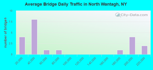
- 1,783,744Total average daily traffic
- 6,364Total average daily truck traffic
- National Bridge Inventory (NBI) Registered Bridges for North Wantagh
- No street view available for this location
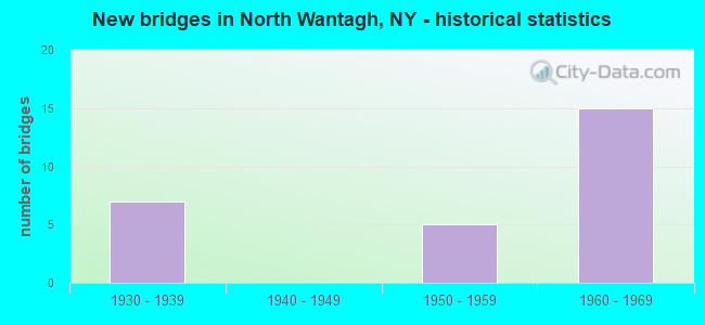
- New bridges - historical statistics
- 71930-1939
- 51950-1959
- 151960-1969
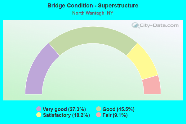
- Bridge Condition - Superstructure
- 27.3%Very good
- 45.5%Good
- 18.2%Satisfactory
- 9.1%Fair
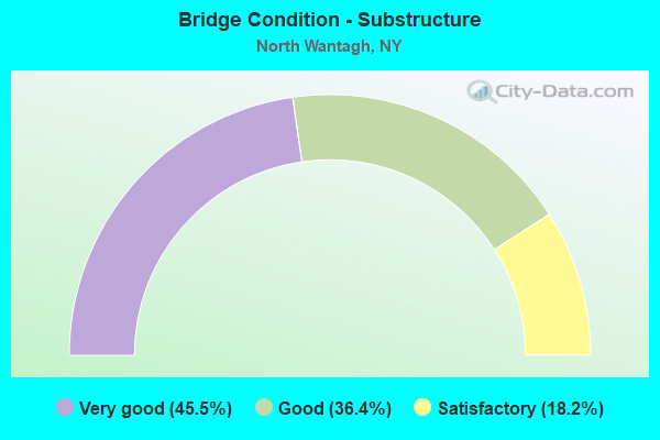
- Bridge Condition - Substructure
- 45.5%Very good
- 36.4%Good
- 18.2%Satisfactory
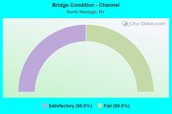
- Bridge Condition - Channel
- 50.0%Satisfactory
- 50.0%Fair
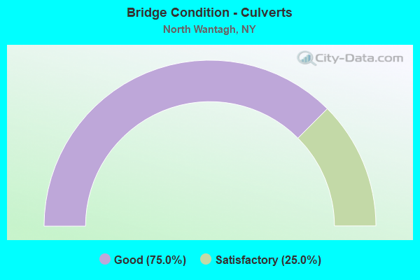
- Bridge Condition - Culverts
- 75.0%Good
- 25.0%Satisfactory
Find on map >> Show street view
Structure Number: 103674, Location: .4 MI S JCT RTS SSP+WSP (Lat: 40.692150, Lng: -73.518264), Route carried "on" structure: State highway 105, Year Built: 1932, Status: Open, Structure Length: 2.53m (8.30ft), Average Daily Traffic: 15,139 (year 2018), Truck Traffic: 3%, Average Future Daily Traffic: 18,390 (year 2040), Design Load: H 20, Features Intersected: RTE 908T
Minimum Vertical Clearance: 30+ m (98+ ft), Kilometerpoint: 2.011, Lanes on structure: 2, Lanes under structure: 3, Base Highway Network: Yes, Owner: State Highway Agency, Approaching Roadway Width: 11.9m (39.0ft), Skew: 23 degrees, Material/Design: Concrete, Design/Construction: Arch - Deck, Number Of Spans In Main Unit: 1, Length of Maximum Span: 23.2m (76.1ft), Curb or Sidewalk Widths: Left: 1.5m (4.9ft), Right: 1.5m (4.9ft), Curb-To-Curb Width: 11.9m (39.0ft), Out-to-Out Width: 16.4m (53.8ft)
Condition: Superstructure: Good, Substructure: Good, Operating Rating: 78.0 metric tons, Method Used To Determine Operating Rating: Load Factor (LF), Inventory Rating: 47.2 metric tons, Method Used To Determine Inventory Rating: Load Factor (LF), Structural Evaluation: Better than present minimum criteria, Deck Geometry: Somewhat better than minimum adequacy, Underclear: High priority of corrective action, Approach Roadway Alignment: Equal to present desirable criteria, Length Of Structure Improvement: 2.52m (8.27ft), Designated Inspection Frequency: Every 24 months, Inspection Date: Febuary 2021, Bridge Improvement Cost: $2,951,000, Roadway Improvement Cost: $1,728,000, Total Project Cost: $4,679,000 ( Estimate for 2021), Wearing Surface/Protective System: Wearing Surface: Integral Concrete
Find on map >> Show street view
Structure Number: 1036759, Location: JCT RTS 105+135 (Lat: 40.691050, Lng: -73.494789), Route carried "on" structure: State highway 135, Year Built: 1965, Status: Open, Structure Length: 5.88m (19.29ft), Average Daily Traffic: 57,712 (year 2019), Truck Traffic: 6%, Average Future Daily Traffic: 68,648 (year 2040), Design Load: H 20, Features Intersected: RTE 105
Minimum Vertical Clearance: 30+ m (98+ ft), Kilometerpoint: 2.864, Lanes on structure: 6, Lanes under structure: 4, Base Highway Network: Yes, Owner: State Highway Agency, Approaching Roadway Width: 26.5m (86.9ft), Skew: 20 degrees, Material/Design: Steel, Design/Construction: Stringer/Multi-beam, Number Of Spans In Main Unit: 4, Length of Maximum Span: 18.8m (61.7ft), Curb-To-Curb Width: 26.5m (86.9ft), Out-to-Out Width: 29.0m (95.1ft)
Condition: Deck: Good, Superstructure: Good, Substructure: Good, Operating Rating: 19.8 metric tons, Method Used To Determine Operating Rating: Load and Resistance Factor Rating (LRFR) rating reported by rating factor(RF) method using HL-93 loadings, Inventory Rating: 15.2 metric tons, Method Used To Determine Inventory Rating: Load and Resistance Factor Rating (LRFR) rating reported by rating factor(RF) method using HL-93 loadings, Structural Evaluation: High priority of corrective action, Deck Geometry: Somewhat better than minimum adequacy, Underclear: Somewhat better than minimum adequacy, Approach Roadway Alignment: Equal to present minimum criteria, Length Of Structure Improvement: 5.88m (19.29ft), Designated Inspection Frequency: Every 24 months, Inspection Date: July 2021, Bridge Improvement Cost: $6,660,000, Roadway Improvement Cost: $3,900,000, Total Project Cost: $10,560,000 ( Estimate for 2021), Deck Structure Type: Concrete Cast-file-Place, Wearing Surface/Protective System: Wearing Surface: Bituminous
Find on map >> Show street view
Structure Number: 1037089, Location: .7 MI E JCT RTS SSP+WSP (Lat: 40.699697, Lng: -73.506453), Route carried "on" structure: Other road , Year Built: 1956, Status: Open, Structure Length: 2.65m (8.69ft), Average Daily Traffic: 34,503 (year 2020), Truck Traffic: 1%, Average Future Daily Traffic: 41,914 (year 2040), Design Load: HS 20, Features Intersected: RTE 908M, Facility Carried by Structure: WANTAGH AVENUE
Minimum Vertical Clearance: 30+ m (98+ ft), Kilometerpoint: 3.926, Lanes on structure: 4, Lanes under structure: 4, Owner: State Highway Agency, Approaching Roadway Width: 17.1m (56.1ft), Skew: 3 degrees, Material/Design: Concrete, Design/Construction: Arch - Deck, Number Of Spans In Main Unit: 1, Length of Maximum Span: 24.3m (79.7ft), Curb or Sidewalk Widths: Left: 1.2m (3.9ft), Right: 1.2m (3.9ft), Curb-To-Curb Width: 17.0m (55.8ft), Out-to-Out Width: 21.0m (68.9ft)
Condition: Superstructure: Satisfactory, Substructure: Satisfactory, Operating Rating: 90.0 metric tons, Method Used To Determine Operating Rating: Field evaluation and documented engineering judgment, Inventory Rating: 32.7 metric tons, Method Used To Determine Inventory Rating: Field evaluation and documented engineering judgment, Structural Evaluation: Equal to present minimum criteria, Deck Geometry: Somewhat better than minimum adequacy, Underclear: High priority of corrective action, Approach Roadway Alignment: Equal to present desirable criteria, Length Of Structure Improvement: 2.65m (8.69ft), Designated Inspection Frequency: Every 24 months, Inspection Date: January 2020, Bridge Improvement Cost: $4,254,000, Roadway Improvement Cost: $2,491,000, Total Project Cost: $6,745,000 ( Estimate for 2021), Wearing Surface/Protective System: Wearing Surface: Bituminous, Membrane: Preformed Fabric
Find on map >> Show street view
Structure Number: 1056579, Location: JCT RTS SSP+WSP (Lat: 40.698594, Lng: -73.521181), Route carried "on" structure: State highway 908M, Year Built: 1956, Status: Open, Structure Length: 0.64m (2.10ft), Average Daily Traffic: 167,213 (year 2020), Average Future Daily Traffic: 198,899 (year 2040), Features Intersected: DRAIN-FOREST C PK
Minimum Vertical Clearance: 30+ m (98+ ft), Kilometerpoint: 18.890, Lanes on structure: 8, Base Highway Network: Yes, Owner: State Highway Agency, Approaching Roadway Width: 49.4m (162.1ft), Skew: 32 degrees, Material/Design: Concrete continuous, Design/Construction: Culvert, Number Of Spans In Main Unit: 2, Length of Maximum Span: 3.0m (9.8ft)
Condition: Channel: Fair, Culverts: Satisfactory, Operating Rating: 74.5 metric tons, Method Used To Determine Operating Rating: Field evaluation and documented engineering judgment, Inventory Rating: 29.4 metric tons, Method Used To Determine Inventory Rating: Field evaluation and documented engineering judgment, Structural Evaluation: Equal to present minimum criteria, Waterway Adequacy: Equal to present minimum criteria, Approach Roadway Alignment: Equal to present desirable criteria, Length Of Structure Improvement: 0.64m (2.10ft), Designated Inspection Frequency: Every 24 months, Inspection Date: September 2021, Bridge Improvement Cost: $1,709,000, Roadway Improvement Cost: $1,001,000, Total Project Cost: $2,710,000 ( Estimate for 2021)
Find on map >> Show street view
Structure Number: 1056689, Location: JCT RTS SSP+WSP (Lat: 40.701911, Lng: -73.521197), Route carried "on" structure: State highway 908T, Year Built: 1938, Status: Open, Structure Length: 0.70m (2.30ft), Average Daily Traffic: 65,299 (year 2018), Truck Traffic: 1%, Average Future Daily Traffic: 77,673 (year 2040), Design Load: HS 20, Features Intersected: DRAIN-FOREST C PK
Minimum Vertical Clearance: 30+ m (98+ ft), Kilometerpoint: 12.711, Lanes on structure: 6, Base Highway Network: Yes, Owner: State Highway Agency, Approaching Roadway Width: 26.5m (86.9ft), Skew: 22 degrees, Material/Design: Concrete continuous, Design/Construction: Culvert, Number Of Spans In Main Unit: 2, Length of Maximum Span: 3.4m (11.2ft)
Condition: Channel: Fair, Culverts: Good, Operating Rating: 74.9 metric tons, Method Used To Determine Operating Rating: Field evaluation and documented engineering judgment, Inventory Rating: 32.7 metric tons, Method Used To Determine Inventory Rating: Field evaluation and documented engineering judgment, Structural Evaluation: Better than present minimum criteria, Waterway Adequacy: Superior to present desirable criteria, Approach Roadway Alignment: Equal to present desirable criteria, Length Of Structure Improvement: 0.70m (2.30ft), Designated Inspection Frequency: Every 24 months, Inspection Date: September 2021, Bridge Improvement Cost: $772,000, Roadway Improvement Cost: $452,000, Total Project Cost: $1,224,000 ( Estimate for 2021)
Find on map >> Show street view
Structure Number: 105669, Location: JCT RTS SSP+WSP (Lat: 40.701058, Lng: -73.521067), Route carried "on" structure: Ramp State highway , Year Built: 1965, Status: Open, Structure Length: 0.70m (2.30ft), Truck Traffic: 2%, Design Load: HS 20, Features Intersected: DRAIN-FOREST C PK, Facility Carried by Structure: WSP SB TO SSP WB
Minimum Vertical Clearance: 30+ m (98+ ft), Kilometerpoint: 0.145, Lanes on structure: 1, Owner: State Highway Agency, Approaching Roadway Width: 9.8m (32.2ft), Skew: 5 degrees, Material/Design: Concrete continuous, Design/Construction: Culvert, Number Of Spans In Main Unit: 2, Length of Maximum Span: 3.4m (11.2ft)
Condition: Channel: Satisfactory, Culverts: Good, Operating Rating: 45.4 metric tons, Method Used To Determine Operating Rating: Load Factor (LF), Inventory Rating: 27.2 metric tons, Method Used To Determine Inventory Rating: Load Factor (LF), Structural Evaluation: Equal to present minimum criteria, Waterway Adequacy: Meets minimum limits, Approach Roadway Alignment: Equal to present desirable criteria, Length Of Structure Improvement: 0.70m (2.30ft), Designated Inspection Frequency: Every 24 months, Inspection Date: September 2021, Bridge Improvement Cost: $518,000, Roadway Improvement Cost: $303,000, Total Project Cost: $822,000 ( Estimate for 2021), Wearing Surface/Protective System: Wearing Surface: Bituminous, Membrane: Preformed Fabric
Find on map >> Show street view
Structure Number: 1056709, Location: JCT RTS SSP+WSP (Lat: 40.699789, Lng: -73.521042), Route carried "on" structure: Ramp Other road , Year Built: 1965, Status: Open, Structure Length: 0.73m (2.40ft), Truck Traffic: 2%, Design Load: H 20, Features Intersected: DRAIN-FOREST C PK, Facility Carried by Structure: SSP WB TO WSP SB &
Minimum Vertical Clearance: 30+ m (98+ ft), Kilometerpoint: 0.467, Lanes on structure: 2, Owner: State Highway Agency, Approaching Roadway Width: 12.5m (41.0ft), Skew: 3 degrees, Material/Design: Concrete continuous, Design/Construction: Culvert, Number Of Spans In Main Unit: 2, Length of Maximum Span: 3.4m (11.2ft)
Condition: Channel: Satisfactory, Culverts: Good, Inventory Rating: 65.3 metric tons, Method Used To Determine Inventory Rating: Load Factor (LF), Structural Evaluation: Better than present minimum criteria, Waterway Adequacy: Equal to present minimum criteria, Approach Roadway Alignment: Better than present minimum criteria, Length Of Structure Improvement: 0.73m (2.40ft), Designated Inspection Frequency: Every 24 months, Inspection Date: September 2021, Bridge Improvement Cost: $378,000, Roadway Improvement Cost: $221,000, Total Project Cost: $599,000 ( Estimate for 2021)
Find on map >> Show street view
Structure Number: 1057049, Location: .7 MILE E JCT SSP & WSP (Lat: 40.700006, Lng: -73.506369), Route carried "on" structure: Other road , Year Built: 1931, Status: Open, Structure Length: 2.37m (7.78ft), Average Daily Traffic: 34,503 (year 2020), Truck Traffic: 1%, Average Future Daily Traffic: 41,914 (year 2040), Features Intersected: RTE 908M, Facility Carried by Structure: WANTAGH AVENUE
Minimum Vertical Clearance: 30+ m (98+ ft), Kilometerpoint: 3.990, Lanes on structure: 4, Lanes under structure: 3, Owner: State Highway Agency, Approaching Roadway Width: 17.1m (56.1ft), Skew: 3 degrees, Material/Design: Concrete, Design/Construction: Arch - Deck, Number Of Spans In Main Unit: 1, Length of Maximum Span: 21.0m (68.9ft), Curb or Sidewalk Widths: Left: 1.2m (3.9ft), Right: 1.1m (3.6ft), Curb-To-Curb Width: 17.0m (55.8ft), Out-to-Out Width: 21.0m (68.9ft)
Condition: Superstructure: Satisfactory, Substructure: Satisfactory, Operating Rating: 59.8 metric tons, Method Used To Determine Operating Rating: Field evaluation and documented engineering judgment, Inventory Rating: 23.3 metric tons, Method Used To Determine Inventory Rating: Field evaluation and documented engineering judgment, Structural Evaluation: Somewhat better than minimum adequacy, Deck Geometry: Somewhat better than minimum adequacy, Underclear: High priority of corrective action, Approach Roadway Alignment: Equal to present desirable criteria, Length Of Structure Improvement: 2.37m (7.78ft), Designated Inspection Frequency: Every 24 months, Inspection Date: January 2020, Bridge Improvement Cost: $3,567,000, Roadway Improvement Cost: $2,089,000, Total Project Cost: $5,655,000 ( Estimate for 2021), Wearing Surface/Protective System: Wearing Surface: Bituminous, Membrane: Preformed Fabric
Find on map >> Show street view
Structure Number: 1057651, Location: JCT RTS SSP+WSP (Lat: 40.698789, Lng: -73.520131), Route carried "on" structure: State highway 908T, Year Built: 1965, Status: Open, Structure Length: 2.32m (7.61ft), Truck Traffic: 2%, Design Load: HS 20, Features Intersected: RTE 908M
Minimum Vertical Clearance: 30+ m (98+ ft), Kilometerpoint: 0.145, Lanes on structure: 4, Lanes under structure: 4, Owner: State Highway Agency, Approaching Roadway Width: 18.6m (61.0ft), Skew: 1 degrees, Material/Design: Concrete, Design/Construction: Arch - Deck, Number Of Spans In Main Unit: 1, Length of Maximum Span: 21.3m (69.9ft), Curb-To-Curb Width: 18.6m (61.0ft), Out-to-Out Width: 20.7m (67.9ft)
Condition: Superstructure: Very good, Substructure: Very good, Operating Rating: 87.8 metric tons, Method Used To Determine Operating Rating: Field evaluation and documented engineering judgment, Inventory Rating: 32.7 metric tons, Method Used To Determine Inventory Rating: Field evaluation and documented engineering judgment, Structural Evaluation: Equal to present desirable criteria, Deck Geometry: Meets minimum limits, Underclear: High priority of corrective action, Approach Roadway Alignment: Equal to present desirable criteria, Length Of Structure Improvement: 2.31m (7.58ft), Designated Inspection Frequency: Every 24 months, Inspection Date: January 2021, Bridge Improvement Cost: $3,929,000, Roadway Improvement Cost: $2,301,000, Total Project Cost: $6,230,000 ( Estimate for 2021), Wearing Surface/Protective System: Wearing Surface: Bituminous, Membrane: Preformed Fabric
Find on map >> Show street view
Structure Number: 1057652, Location: JCT RTS SSP+WSP (Lat: 40.698581, Lng: -73.518592), Route carried "on" structure: State highway 908T, Year Built: 1956, Status: Open, Structure Length: 2.38m (7.81ft), Average Daily Traffic: 32,650 (year 2019), Truck Traffic: 1%, Average Future Daily Traffic: 38,836 (year 2040), Design Load: HS 20, Features Intersected: RTE 908M
Minimum Vertical Clearance: 30+ m (98+ ft), Kilometerpoint: 12.228, Lanes on structure: 4, Lanes under structure: 4, Base Highway Network: Yes, Owner: State Highway Agency, Approaching Roadway Width: 18.6m (61.0ft), Skew: 21 degrees, Material/Design: Concrete, Design/Construction: Arch - Deck, Number Of Spans In Main Unit: 1, Length of Maximum Span: 22.2m (72.8ft), Curb or Sidewalk Widths: Left: 0.0m, Right: 5.5m (18.0ft), Curb-To-Curb Width: 17.4m (57.1ft), Out-to-Out Width: 27.9m (91.5ft)
Condition: Superstructure: Very good, Substructure: Very good, Operating Rating: 88.5 metric tons, Method Used To Determine Operating Rating: Field evaluation and documented engineering judgment, Inventory Rating: 32.7 metric tons, Method Used To Determine Inventory Rating: Field evaluation and documented engineering judgment, Structural Evaluation: Equal to present desirable criteria, Deck Geometry: Meets minimum limits, Underclear: High priority of corrective action, Approach Roadway Alignment: Equal to present minimum criteria, Length Of Structure Improvement: 2.37m (7.78ft), Designated Inspection Frequency: Every 24 months, Inspection Date: January 2021, Bridge Improvement Cost: $5,418,000, Roadway Improvement Cost: $3,173,000, Total Project Cost: $8,591,000 ( Estimate for 2021), Wearing Surface/Protective System: Wearing Surface: Bituminous, Membrane: Preformed Fabric
Find on map >> Show street view
Structure Number: 10577, Location: JCT RTS 105 & WSP (Lat: 40.692125, Lng: -73.518736), Route carried "on" structure: State highway 105, Year Built: 1967, Status: Open, Structure Length: 2.53m (8.30ft), Average Daily Traffic: 15,139 (year 2018), Truck Traffic: 3%, Average Future Daily Traffic: 18,390 (year 2040), Design Load: HS 20, Features Intersected: RTE 908T
Minimum Vertical Clearance: 30+ m (98+ ft), Kilometerpoint: 2.011, Lanes on structure: 2, Lanes under structure: 3, Base Highway Network: Yes, Owner: State Highway Agency, Approaching Roadway Width: 11.9m (39.0ft), Skew: 23 degrees, Material/Design: Concrete, Design/Construction: Arch - Deck, Number Of Spans In Main Unit: 1, Length of Maximum Span: 23.1m (75.8ft), Curb or Sidewalk Widths: Left: 1.5m (4.9ft), Right: 1.5m (4.9ft), Curb-To-Curb Width: 11.9m (39.0ft), Out-to-Out Width: 16.4m (53.8ft)
Condition: Superstructure: Good, Substructure: Good, Operating Rating: 89.1 metric tons, Method Used To Determine Operating Rating: Field evaluation and documented engineering judgment, Inventory Rating: 32.7 metric tons, Method Used To Determine Inventory Rating: Field evaluation and documented engineering judgment, Structural Evaluation: Better than present minimum criteria, Deck Geometry: Somewhat better than minimum adequacy, Underclear: High priority of corrective action, Approach Roadway Alignment: Equal to present desirable criteria, Length Of Structure Improvement: 2.52m (8.27ft), Designated Inspection Frequency: Every 24 months, Inspection Date: Febuary 2021, Bridge Improvement Cost: $3,437,000, Roadway Improvement Cost: $2,013,000, Total Project Cost: $5,450,000 ( Estimate for 2021), Wearing Surface/Protective System: Wearing Surface: Integral Concrete
Find on map >> Show street view
Structure Number: 105855, Location: JCT RTS SSP+WSP (Lat: 40.696939, Lng: -73.519006), Route carried "on" structure: Ramp State highway , Year Built: 1965, Status: Open, Structure Length: 1.89m (6.20ft), Truck Traffic: 2%, Design Load: HS 20, Features Intersected: RTE 908T, Facility Carried by Structure: WSP SB TO SSP EB
Minimum Vertical Clearance: 30+ m (98+ ft), Kilometerpoint: 0.370, Lanes on structure: 1, Lanes under structure: 3, Owner: State Highway Agency, Approaching Roadway Width: 9.1m (29.9ft), Material/Design: Concrete, Design/Construction: Arch - Deck, Number Of Spans In Main Unit: 1, Length of Maximum Span: 17.3m (56.8ft), Curb-To-Curb Width: 9.1m (29.9ft), Out-to-Out Width: 10.4m (34.1ft)
Condition: Superstructure: Good, Substructure: Very good, Operating Rating: 84.9 metric tons, Method Used To Determine Operating Rating: Field evaluation and documented engineering judgment, Inventory Rating: 32.7 metric tons, Method Used To Determine Inventory Rating: Field evaluation and documented engineering judgment, Structural Evaluation: Better than present minimum criteria, Deck Geometry: Superior to present desirable criteria, Underclear: High priority of corrective action, Approach Roadway Alignment: Better than present minimum criteria, Length Of Structure Improvement: 1.88m (6.17ft), Designated Inspection Frequency: Every 24 months, Inspection Date: January 2021, Bridge Improvement Cost: $1,574,000, Roadway Improvement Cost: $922,000, Total Project Cost: $2,496,000 ( Estimate for 2021), Wearing Surface/Protective System: Wearing Surface: Bituminous, Membrane: Preformed Fabric
Find on map >> Show street view
Structure Number: 105856, Location: JCT RTS SSP+WSP (Lat: 40.700142, Lng: -73.520356), Route carried "on" structure: Ramp State highway , Year Built: 1965, Status: Open, Structure Length: 2.04m (6.69ft), Truck Traffic: 2%, Design Load: HS 20, Features Intersected: RTE 908T, Facility Carried by Structure: WSP NB TO SSP WB
Minimum Vertical Clearance: 30+ m (98+ ft), Kilometerpoint: 0.193, Lanes on structure: 1, Lanes under structure: 2, Owner: State Highway Agency, Approaching Roadway Width: 8.2m (26.9ft), Skew: 2 degrees, Material/Design: Concrete, Design/Construction: Arch - Deck, Number Of Spans In Main Unit: 1, Length of Maximum Span: 18.8m (61.7ft), Curb-To-Curb Width: 8.2m (26.9ft), Out-to-Out Width: 10.4m (34.1ft)
Condition: Superstructure: Very good, Substructure: Very good, Operating Rating: 86.0 metric tons, Method Used To Determine Operating Rating: Field evaluation and documented engineering judgment, Inventory Rating: 32.7 metric tons, Method Used To Determine Inventory Rating: Field evaluation and documented engineering judgment, Structural Evaluation: Equal to present desirable criteria, Deck Geometry: Superior to present desirable criteria, Underclear: High priority of corrective action, Approach Roadway Alignment: Better than present minimum criteria, Length Of Structure Improvement: 2.04m (6.69ft), Designated Inspection Frequency: Every 24 months, Inspection Date: January 2021, Bridge Improvement Cost: $1,792,000, Roadway Improvement Cost: $1,049,000, Total Project Cost: $2,841,000 ( Estimate for 2021), Wearing Surface/Protective System: Wearing Surface: Bituminous
Find on map >> Show street view
Structure Number: 1059651, Location: JCT RTS SSP+WSP (Lat: 40.698428, Lng: -73.520133), Route carried "on" structure: State highway 908T, Year Built: 1965, Status: Open, Structure Length: 2.32m (7.61ft), Truck Traffic: 2%, Design Load: HS 20, Features Intersected: RTE 908M
Minimum Vertical Clearance: 30+ m (98+ ft), Kilometerpoint: 0.177, Lanes on structure: 4, Lanes under structure: 3, Owner: State Highway Agency, Approaching Roadway Width: 18.6m (61.0ft), Skew: 1 degrees, Material/Design: Concrete, Design/Construction: Arch - Deck, Number Of Spans In Main Unit: 1, Length of Maximum Span: 21.3m (69.9ft), Curb-To-Curb Width: 18.6m (61.0ft), Out-to-Out Width: 20.7m (67.9ft)
Condition: Superstructure: Good, Substructure: Very good, Operating Rating: 87.8 metric tons, Method Used To Determine Operating Rating: Field evaluation and documented engineering judgment, Inventory Rating: 32.7 metric tons, Method Used To Determine Inventory Rating: Field evaluation and documented engineering judgment, Structural Evaluation: Better than present minimum criteria, Deck Geometry: Meets minimum limits, Underclear: High priority of corrective action, Approach Roadway Alignment: Equal to present desirable criteria, Length Of Structure Improvement: 2.31m (7.58ft), Designated Inspection Frequency: Every 24 months, Inspection Date: January 2021, Bridge Improvement Cost: $3,929,000, Roadway Improvement Cost: $2,301,000, Total Project Cost: $6,230,000 ( Estimate for 2021), Wearing Surface/Protective System: Wearing Surface: Bituminous, Membrane: Preformed Fabric
Find on map >> Show street view
Structure Number: 1059652, Location: JCT RTS SSP+WSP (Lat: 40.698269, Lng: -73.518558), Route carried "on" structure: State highway 908T, Year Built: 1931, Status: Open, Structure Length: 2.01m (6.59ft), Average Daily Traffic: 32,650 (year 2018), Truck Traffic: 1%, Average Future Daily Traffic: 38,836 (year 2040), Design Load: HS 20, Features Intersected: RTE 908M
Minimum Vertical Clearance: 30+ m (98+ ft), Kilometerpoint: 12.277, Lanes on structure: 4, Lanes under structure: 3, Base Highway Network: Yes, Owner: State Highway Agency, Approaching Roadway Width: 18.6m (61.0ft), Skew: 20 degrees, Material/Design: Concrete, Design/Construction: Arch - Deck, Number Of Spans In Main Unit: 1, Length of Maximum Span: 17.6m (57.7ft), Curb or Sidewalk Widths: Left: 0.0m, Right: 5.5m (18.0ft), Curb-To-Curb Width: 18.0m (59.1ft), Out-to-Out Width: 27.9m (91.5ft)
Condition: Superstructure: Fair, Substructure: Good, Operating Rating: 85.2 metric tons, Method Used To Determine Operating Rating: Field evaluation and documented engineering judgment, Inventory Rating: 32.7 metric tons, Method Used To Determine Inventory Rating: Field evaluation and documented engineering judgment, Structural Evaluation: Somewhat better than minimum adequacy, Deck Geometry: Meets minimum limits, Underclear: High priority of corrective action, Approach Roadway Alignment: Equal to present desirable criteria, Length Of Structure Improvement: 2.01m (6.59ft), Designated Inspection Frequency: Every 24 months, Inspection Date: January 2021, Bridge Improvement Cost: $4,694,000, Roadway Improvement Cost: $2,749,000, Total Project Cost: $7,443,000 ( Estimate for 2021), Wearing Surface/Protective System: Wearing Surface: Bituminous, Membrane: Preformed Fabric
Find on map >> Show street view
Structure Number: 103674, Location: .4 MI S JCT RTS SSP+WSP (Lat: 40.692150, Lng: -73.518264), Route carried "under" structure: State highway 908T, Year Built: 1932, Structure Length: 0. m, Average Daily Traffic: 31,155 (year 2002), Features Intersected: RTE 908T, Facility Carried by Structure: RTE 105
Minimum Vertical Clearance: 4.45m (14.60ft), Kilometerpoint: 11.279, Lanes on structure: 2, Lanes under structure: 3, Material/Design: Concrete, Design/Construction: Arch - Deck, Length of Maximum Span: 23.2m (76.1ft)
Find on map >> Show street view
Structure Number: 1036759, Location: JCT RTS 105+135 (Lat: 40.691050, Lng: -73.494789), Route carried "under" structure: State highway 105, Year Built: 1965, Structure Length: 0. m, Average Daily Traffic: 16,342 (year 2002), Features Intersected: RTE 105, Facility Carried by Structure: RTE 135
Minimum Vertical Clearance: 4.47m (14.67ft), Kilometerpoint: 4.167, Lanes on structure: 6, Lanes under structure: 4, Material/Design: Steel, Design/Construction: Stringer/Multi-beam, Length of Maximum Span: 18.8m (61.7ft)
Find on map >> Show street view
Structure Number: 1037089, Location: .7 MI E JCT RTS SSP+WSP (Lat: 40.699697, Lng: -73.506453), Route carried "under" structure: State highway 908M, Year Built: 1956, Structure Length: 0. m, Average Daily Traffic: 209,621 (year 2002), Features Intersected: RTE 908M, Facility Carried by Structure: WANTAGH AVENUE
Minimum Vertical Clearance: 4.14m (13.58ft), Kilometerpoint: 4.023, Lanes on structure: 4, Lanes under structure: 4, Material/Design: Concrete, Design/Construction: Arch - Deck, Length of Maximum Span: 24.3m (79.7ft)
Find on map >> Show street view
Structure Number: 10378, Location: .3 MI S JCT RTS 135 & SSP (Lat: 40.696803, Lng: -73.492414), Route carried "under" structure: State highway , Year Built: 1965, Structure Length: 0. m, Average Daily Traffic: 1,000 (year 2021), Features Intersected: 135 135 03011033, RTE 13, Facility Carried by Structure: PED BR S OF SSP
Minimum Vertical Clearance: 4.34m (14.24ft), Kilometerpoint: 3.878, Lanes under structure: 2, Material/Design: Steel, Design/Construction: Stringer/Multi-beam, Length of Maximum Span: 34.7m (113.8ft)
Find on map >> Show street view
Structure Number: 1057049, Location: .7 MILE E JCT SSP & WSP (Lat: 40.700006, Lng: -73.506369), Route carried "under" structure: State highway 908M, Year Built: 1931, Structure Length: 0. m, Average Daily Traffic: 209,621 (year 2002), Features Intersected: RTE 908M, Facility Carried by Structure: WANTAGH AVENUE
Minimum Vertical Clearance: 4.01m (13.16ft), Kilometerpoint: 4.023, Lanes on structure: 4, Lanes under structure: 3, Material/Design: Concrete, Design/Construction: Arch - Deck, Length of Maximum Span: 21.0m (68.9ft)
Find on map >> Show street view
Structure Number: 1057651, Location: JCT RTS SSP+WSP (Lat: 40.698789, Lng: -73.520131), Route carried "under" structure: State highway 908M, Year Built: 1965, Structure Length: 0. m, Average Daily Traffic: 191,933 (year 2002), Features Intersected: RTE 908M, Facility Carried by Structure: RTE 908T
Minimum Vertical Clearance: 4.37m (14.34ft), Kilometerpoint: 19.147, Lanes on structure: 4, Lanes under structure: 4, Material/Design: Concrete, Design/Construction: Arch - Deck, Length of Maximum Span: 21.3m (69.9ft)
Find on map >> Show street view
Structure Number: 1057652, Location: JCT RTS SSP+WSP (Lat: 40.698581, Lng: -73.518592), Route carried "under" structure: State highway 908M, Year Built: 1956, Structure Length: 0. m, Average Daily Traffic: 191,933 (year 2002), Features Intersected: RTE 908M, Facility Carried by Structure: RTE 908T
Minimum Vertical Clearance: 4.06m (13.32ft), Kilometerpoint: 19.147, Lanes on structure: 4, Lanes under structure: 4, Material/Design: Concrete, Design/Construction: Arch - Deck, Length of Maximum Span: 22.2m (72.8ft)
Find on map >> Show street view
Structure Number: 10577, Location: JCT RTS 105 & WSP (Lat: 40.692125, Lng: -73.518736), Route carried "under" structure: State highway 908T, Year Built: 1967, Structure Length: 0. m, Average Daily Traffic: 31,155 (year 2002), Features Intersected: RTE 908T, Facility Carried by Structure: RTE 105
Minimum Vertical Clearance: 4.32m (14.17ft), Kilometerpoint: 11.279, Lanes on structure: 2, Lanes under structure: 3, Material/Design: Concrete, Design/Construction: Arch - Deck, Length of Maximum Span: 23.1m (75.8ft)
Find on map >> Show street view
Structure Number: 105855, Location: JCT RTS SSP+WSP (Lat: 40.696939, Lng: -73.519006), Route carried "under" structure: State highway 908T, Year Built: 1965, Structure Length: 0. m, Average Daily Traffic: 31,155 (year 2002), Features Intersected: RTE 908T, Facility Carried by Structure: WSP SB TO SSP EB
Minimum Vertical Clearance: 4.32m (14.17ft), Kilometerpoint: 11.874, Lanes on structure: 1, Lanes under structure: 3, Material/Design: Concrete, Design/Construction: Arch - Deck, Length of Maximum Span: 17.3m (56.8ft)
Find on map >> Show street view
Structure Number: 105856, Location: JCT RTS SSP+WSP (Lat: 40.700142, Lng: -73.520356), Route carried "under" structure: State highway 908T, Year Built: 1965, Structure Length: 0. m, Average Daily Traffic: 31,155 (year 2002), Features Intersected: RTE 908T, Facility Carried by Structure: WSP NB TO SSP WB
Minimum Vertical Clearance: 4.26m (13.98ft), Kilometerpoint: 12.196, Lanes on structure: 1, Lanes under structure: 2, Material/Design: Concrete, Design/Construction: Arch - Deck, Length of Maximum Span: 18.8m (61.7ft)
Find on map >> Show street view
Structure Number: 1059651, Location: JCT RTS SSP+WSP (Lat: 40.698428, Lng: -73.520133), Route carried "under" structure: State highway 908M, Year Built: 1965, Structure Length: 0. m, Average Daily Traffic: 191,933 (year 2002), Features Intersected: RTE 908M, Facility Carried by Structure: RTE 908T
Minimum Vertical Clearance: 4.29m (14.07ft), Kilometerpoint: 19.147, Lanes on structure: 4, Lanes under structure: 3, Material/Design: Concrete, Design/Construction: Arch - Deck, Length of Maximum Span: 21.3m (69.9ft)
Find on map >> Show street view
Structure Number: 1059652, Location: JCT RTS SSP+WSP (Lat: 40.698269, Lng: -73.518558), Route carried "under" structure: State highway 908M, Year Built: 1931, Structure Length: 0. m, Average Daily Traffic: 191,933 (year 2002), Features Intersected: RTE 908M, Facility Carried by Structure: RTE 908T
Minimum Vertical Clearance: 3.84m (12.60ft), Kilometerpoint: 19.147, Lanes on structure: 4, Lanes under structure: 3, Material/Design: Concrete, Design/Construction: Arch - Deck, Length of Maximum Span: 17.6m (57.7ft)