Bridge Statistics for Northglenn, Colorado (CO)
Condition, Traffic, Stress, Structural Evaluation, Project Costs
- National Bridge Inventory (NBI) Statistics
- 12Number of bridges
- 98ft / 29.9mTotal length
- 618,198Total average daily traffic
- 43,691Total average daily truck traffic
- National Bridge Inventory (NBI) Registered Bridges for Northglenn
- No street view available for this location
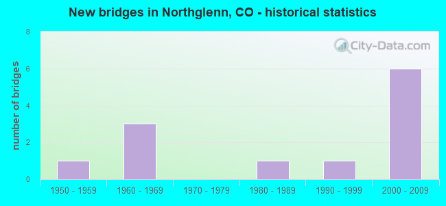
- New bridges - historical statistics
- 11950-1959
- 31960-1969
- 11980-1989
- 11990-1999
- 62000-2009
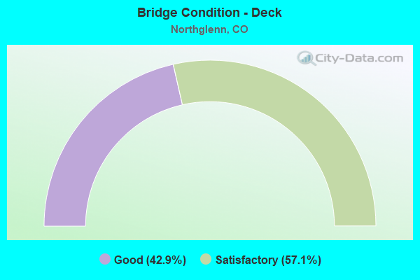
- Bridge Condition - Deck
- 42.9%Good
- 57.1%Satisfactory
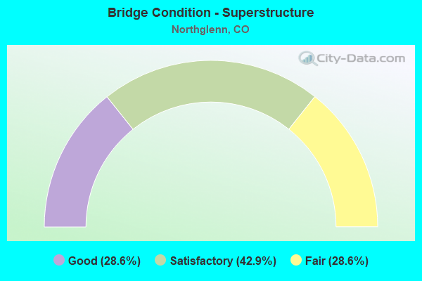
- Bridge Condition - Superstructure
- 28.6%Good
- 42.9%Satisfactory
- 28.6%Fair
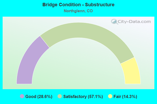
- Bridge Condition - Substructure
- 28.6%Good
- 57.1%Satisfactory
- 14.3%Fair
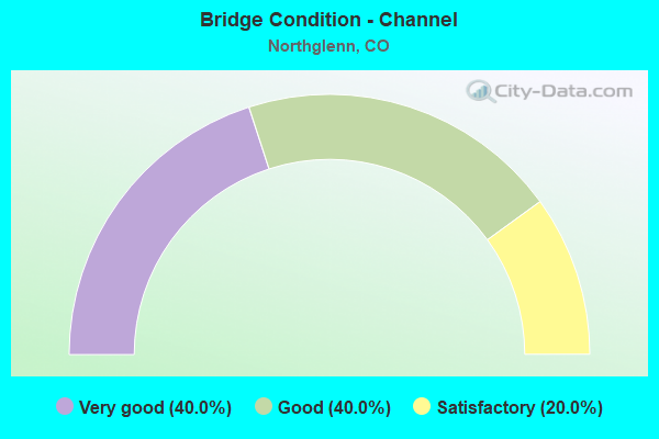
- Bridge Condition - Channel
- 40.0%Very good
- 40.0%Good
- 20.0%Satisfactory
Find on map >> Show street view
Structure Number: E-17-ADP, Location: IN NORTHGLENN (Lat: 39.885122, Lng: -104.988050), Route carried "on" structure: City street , Year Built: 2009, Status: Open, Structure Length: 7.85m (25.75ft), Average Daily Traffic: 31,113 (year 2021), Truck Traffic: 1%, Average Future Daily Traffic: 40,448 (year 2041), Features Intersected: I 25 ML, Facility Carried by Structure: 104TH AVE
Minimum Vertical Clearance: 30+ m (98+ ft), Kilometerpoint: 0.478, Lanes on structure: 10, Lanes under structure: 8, Owner: State Highway Agency, Approaching Roadway Width: 39.0m (128.0ft), Skew: 20 degrees, Material/Design: Prestressed concrete continuous, Design/Construction: Box Beam or Girders - Multiple, Number Of Spans In Main Unit: 2, Length of Maximum Span: 38.1m (125.0ft), Curb or Sidewalk Widths: Left: 2.4m (7.9ft), Right: 2.4m (7.9ft), Curb-To-Curb Width: 39.0m (128.0ft), Out-to-Out Width: 44.8m (147.0ft)
Condition: Deck: Good, Superstructure: Good, Substructure: Good, Inventory Rating: 71.0 metric tons, Method Used To Determine Inventory Rating: Load Factor (LF), Structural Evaluation: Better than present minimum criteria, Deck Geometry: Somewhat better than minimum adequacy, Underclear: Better than present minimum criteria, Approach Roadway Alignment: Equal to present desirable criteria, Designated Inspection Frequency: Every 24 months, Inspection Date: May 2020, Deck Structure Type: Concrete Cast-file-Place, Wearing Surface/Protective System: Wearing Surface: Bituminous, Membrane: Built-up, Deck Protection: Epoxy Coated Reinforcing
Find on map >> Show street view
Structure Number: E-17-FI, Location: NORTHGLENN (Lat: 39.897864, Lng: -104.987403), Route carried "on" structure: Interstate 25A, Year Built: 1954, Status: Open, Structure Length: 1.13m (3.71ft), Average Daily Traffic: 135,000 (year 2020), Truck Traffic: 9%, Average Future Daily Traffic: 183,600 (year 2040), Design Load: HS 20, Features Intersected: FARMERS HIGHLINE CANAL, Facility Carried by Structure: I 25 ML
Minimum Vertical Clearance: 30+ m (98+ ft), Kilometerpoint: 356.853, Lanes on structure: 8, Base Highway Network: Yes, Owner: State Highway Agency, Approaching Roadway Width: 37.8m (124.0ft), Skew: 34 degrees, Material/Design: Steel, Design/Construction: Stringer/Multi-beam, Number Of Spans In Main Unit: 1, Length of Maximum Span: 9.6m (31.5ft), Curb-To-Curb Width: 37.8m (124.0ft), Out-to-Out Width: 39.1m (128.3ft)
Condition: Deck: Satisfactory, Superstructure: Satisfactory, Substructure: Satisfactory, Channel: Very good, Operating Rating: 48.3 metric tons, Method Used To Determine Operating Rating: Load Factor (LF), Inventory Rating: 28.8 metric tons, Method Used To Determine Inventory Rating: Load Factor (LF), Structural Evaluation: Equal to present minimum criteria, Deck Geometry: Superior to present desirable criteria, Waterway Adequacy: Superior to present desirable criteria, Approach Roadway Alignment: Equal to present desirable criteria, Designated Inspection Frequency: Every 24 months, Inspection Date: May 2020, Deck Structure Type: Concrete Cast-file-Place, Wearing Surface/Protective System: Wearing Surface: Bituminous
Find on map >> Show street view
Structure Number: E-17-KJ, Location: .2 MI S OF JCT SH 128-120 (Lat: 39.910900, Lng: -104.990606), Route carried "on" structure: Interstate 25A, Year Built: 1992, Status: Open, Structure Length: 1.16m (3.81ft), Average Daily Traffic: 67,500 (year 2020), Truck Traffic: 9%, Average Future Daily Traffic: 91,800 (year 2040), Design Load: HS 20+Mod, Features Intersected: WAGON RD RTD RAMP R, Facility Carried by Structure: I 25 SBND
Minimum Vertical Clearance: 30+ m (98+ ft), Kilometerpoint: 358.333, Lanes on structure: 5, Lanes under structure: 1, Base Highway Network: Yes, Owner: State Highway Agency, Approaching Roadway Width: 26.8m (87.9ft), Skew: 9 degrees, Material/Design: Concrete, Design/Construction: Slab, Number Of Spans In Main Unit: 1, Length of Maximum Span: 9.0m (29.5ft), Curb-To-Curb Width: 27.4m (89.9ft), Out-to-Out Width: 116.1m (380.9ft)
Condition: Deck: Satisfactory, Superstructure: Satisfactory, Substructure: Satisfactory, Operating Rating: 58.3 metric tons, Method Used To Determine Operating Rating: Load and Resistance Factor Rating (LRFR) rating reported by rating factor(RF) method using HL-93 loadings, Inventory Rating: 45.4 metric tons, Method Used To Determine Inventory Rating: Load and Resistance Factor Rating (LRFR) rating reported by rating factor(RF) method using HL-93 loadings, Structural Evaluation: Equal to present minimum criteria, Deck Geometry: Superior to present desirable criteria, Underclear: Meets minimum limits, Approach Roadway Alignment: Equal to present desirable criteria, Designated Inspection Frequency: Every 24 months, Inspection Date: May 2020
Find on map >> Show street view
Structure Number: E-17-ZW, Location: 1.8 MI E OF JCT US 287 (Lat: 39.913833, Lng: -104.990408), Route carried "on" structure: State highway 128B, Year Built: 2006, Status: Open, Structure Length: 8.38m (27.49ft), Average Daily Traffic: 51,000 (year 2020), Truck Traffic: 3%, Average Future Daily Traffic: 56,100 (year 2040), Design Load: HL 93, Features Intersected: I 25 ML, Facility Carried by Structure: SH 128 ML/120TH AV
Minimum Vertical Clearance: 30+ m (98+ ft), Kilometerpoint: 2.960, Lanes on structure: 10, Lanes under structure: 8, Base Highway Network: Yes, Owner: State Highway Agency, Approaching Roadway Width: 37.8m (124.0ft), Skew: 22 degrees, Material/Design: Prestressed concrete continuous, Design/Construction: Box Beam or Girders - Multiple, Number Of Spans In Main Unit: 2, Length of Maximum Span: 41.1m (134.8ft), Curb or Sidewalk Widths: Left: 3.7m (12.1ft), Right: 2.4m (7.9ft), Curb-To-Curb Width: 39.3m (128.9ft), Out-to-Out Width: 46.3m (151.9ft)
Condition: Deck: Good, Superstructure: Good, Substructure: Good, Operating Rating: 39.9 metric tons, Method Used To Determine Operating Rating: Load and Resistance Factor Rating (LRFR) rating reported by rating factor(RF) method using HL-93 loadings, Inventory Rating: 19.1 metric tons, Method Used To Determine Inventory Rating: Load and Resistance Factor Rating (LRFR) rating reported by rating factor(RF) method using HL-93 loadings, Structural Evaluation: Meets minimum limits, Deck Geometry: Somewhat better than minimum adequacy, Underclear: Equal to present minimum criteria, Approach Roadway Alignment: Equal to present desirable criteria, Designated Inspection Frequency: Every 24 months, Inspection Date: May 2020, Deck Structure Type: Concrete Cast-file-Place, Wearing Surface/Protective System: Wearing Surface: Bituminous, Membrane: Built-up, Deck Protection: Epoxy Coated Reinforcing
Find on map >> Show street view
Structure Number: NGLN-AC-0.8-104, Location: .8 MI N OF 104TH AVENUE (Lat: 39.897292, Lng: -104.988600), Route carried "on" structure: City street , Year Built: 1960, Status: Open, Structure Length: 0.63m (2.07ft), Average Daily Traffic: 126 (year 2021), Average Future Daily Traffic: 164 (year 2041), Features Intersected: FARMERS HIGHLINE CA, Facility Carried by Structure: ACOMA STREET
Minimum Vertical Clearance: 30+ m (98+ ft), Kilometerpoint: 0.328, Lanes on structure: 2, Owner: City or Municipal Highway Agency, Approaching Roadway Width: 12.2m (40.0ft), Skew: 2 degrees, Material/Design: Concrete, Design/Construction: Culvert, Number Of Spans In Main Unit: 1, Length of Maximum Span: 6.3m (20.7ft), Curb or Sidewalk Widths: Left: 1.3m (4.3ft), Right: 1.3m (4.3ft), Curb-To-Curb Width: 14.8m (48.6ft), Out-to-Out Width: 15.3m (50.2ft)
Condition: Channel: Good, Culverts: Good, Operating Rating: 36.3 metric tons, Method Used To Determine Operating Rating: Field evaluation and documented engineering judgment, Inventory Rating: 32.7 metric tons, Method Used To Determine Inventory Rating: Field evaluation and documented engineering judgment, Structural Evaluation: Better than present minimum criteria, Deck Geometry: Superior to present desirable criteria, Waterway Adequacy: Equal to present desirable criteria, Approach Roadway Alignment: Equal to present desirable criteria, Designated Inspection Frequency: Every 24 months, Inspection Date: January 2022
Find on map >> Show street view
Structure Number: NGLN-CCDR-I25, Location: 112th OVER I-25 (Lat: 39.901736, Lng: -104.988519), Route carried "on" structure: City street , Year Built: 2004, Status: Open, Structure Length: 8.66m (28.41ft), Average Daily Traffic: 17,321 (year 2021), Truck Traffic: 10%, Average Future Daily Traffic: 22,517 (year 2041), Design Load: HS 25 or greater, Features Intersected: I-25, Facility Carried by Structure: COMMUNITY CENTR DR
Minimum Vertical Clearance: 30+ m (98+ ft), Kilometerpoint: 1.190, Lanes on structure: 4, Lanes under structure: 8, Owner: City or Municipal Highway Agency, Approaching Roadway Width: 16.5m (54.1ft), Skew: 22 degrees, Material/Design: Prestressed concrete continuous, Design/Construction: Box Beam or Girders - Single/Spread, Number Of Spans In Main Unit: 2, Length of Maximum Span: 41.8m (137.1ft), Curb or Sidewalk Widths: Left: 3.2m (10.5ft), Right: 0.0m, Curb-To-Curb Width: 16.5m (54.1ft), Out-to-Out Width: 22.2m (72.8ft)
Condition: Deck: Good, Superstructure: Satisfactory, Substructure: Satisfactory, Operating Rating: 39.2 metric tons, Method Used To Determine Operating Rating: Load and Resistance Factor Rating (LRFR) rating reported by rating factor(RF) method using HL-93 loadings, Inventory Rating: 22.7 metric tons, Method Used To Determine Inventory Rating: Load and Resistance Factor Rating (LRFR) rating reported by rating factor(RF) method using HL-93 loadings, Structural Evaluation: Somewhat better than minimum adequacy, Deck Geometry: Meets minimum limits, Underclear: Equal to present minimum criteria, Approach Roadway Alignment: Equal to present desirable criteria, Designated Inspection Frequency: Every 24 months, Inspection Date: January 2022, Deck Structure Type: Concrete Cast-file-Place, Wearing Surface/Protective System: Wearing Surface: Bituminous, Membrane: Built-up, Deck Protection: Epoxy Coated Reinforcing
Find on map >> Show street view
Structure Number: NGLN-CL-0.4-12, Location: 0.4 MI N OF 120TH AVE (Lat: 39.918867, Lng: -104.960361), Route carried "on" structure: City street , Year Built: 1986, Status: Open, Structure Length: 0.66m (2.17ft), Average Daily Traffic: 3,234 (year 2021), Truck Traffic: 2%, Average Future Daily Traffic: 4,204 (year 2041), Design Load: HS 20, Features Intersected: BRANTNER GULCH, Facility Carried by Structure: CLAUDE COURT
Minimum Vertical Clearance: 30+ m (98+ ft), Kilometerpoint: 2.109, Lanes on structure: 2, Owner: City or Municipal Highway Agency, Approaching Roadway Width: 11.6m (38.1ft), Skew: 1 degrees, Material/Design: Concrete, Design/Construction: Culvert, Number Of Spans In Main Unit: 2, Length of Maximum Span: 3.1m (10.2ft), Curb or Sidewalk Widths: Left: 2.3m (7.5ft), Right: 0.0m, Out-to-Out Width: 22.0m (72.2ft)
Condition: Channel: Satisfactory, Culverts: Good, Operating Rating: 29.9 metric tons, Method Used To Determine Operating Rating: Load Factor (LF), Inventory Rating: 18.0 metric tons, Method Used To Determine Inventory Rating: Load Factor (LF), Structural Evaluation: Somewhat better than minimum adequacy, Waterway Adequacy: Equal to present minimum criteria, Approach Roadway Alignment: Equal to present desirable criteria, Designated Inspection Frequency: Every 24 months, Inspection Date: January 2022
Find on map >> Show street view
Structure Number: NGLN-HI-0.0-112, Location: JUST W OF NORTHGLENN DR (Lat: 39.900156, Lng: -104.985647), Route carried "on" structure: City street , Year Built: 1960, Status: Open, Structure Length: 0.71m (2.33ft), Average Daily Traffic: 555 (year 2021), Average Future Daily Traffic: 721 (year 2041), Features Intersected: FARMERS HIGHLINE CA, Facility Carried by Structure: 112TH PLACE
Minimum Vertical Clearance: 30+ m (98+ ft), Kilometerpoint: 0.004, Lanes on structure: 2, Owner: City or Municipal Highway Agency, Approaching Roadway Width: 11.0m (36.1ft), Material/Design: Prestressed concrete, Design/Construction: Tee Beam, Number Of Spans In Main Unit: 1, Length of Maximum Span: 6.1m (20.0ft), Curb or Sidewalk Widths: Left: 1.6m (5.2ft), Right: 1.2m (3.9ft), Curb-To-Curb Width: 11.1m (36.4ft), Out-to-Out Width: 17.1m (56.1ft)
Condition: Deck: Satisfactory, Superstructure: Fair, Substructure: Satisfactory, Channel: Very good, Operating Rating: 36.3 metric tons, Method Used To Determine Operating Rating: Field evaluation and documented engineering judgment, Inventory Rating: 32.7 metric tons, Method Used To Determine Inventory Rating: Field evaluation and documented engineering judgment, Structural Evaluation: Somewhat better than minimum adequacy, Deck Geometry: Better than present minimum criteria, Waterway Adequacy: Equal to present desirable criteria, Approach Roadway Alignment: Equal to present minimum criteria, Designated Inspection Frequency: Every 24 months, Inspection Date: January 2022, Deck Structure Type: Concrete Cast-file-Place, Wearing Surface/Protective System: Wearing Surface: Bituminous
Find on map >> Show street view
Structure Number: NGLN-MA-0.3-112, Location: JUST E OF HIGHLINE DRIVE (Lat: 39.903478, Lng: -104.983436), Route carried "on" structure: City street , Year Built: 1960, Status: Open, Structure Length: 0.73m (2.40ft), Average Daily Traffic: 13,261 (year 2021), Average Future Daily Traffic: 17,240 (year 2041), Features Intersected: FARMERS HIGHLINE CA, Facility Carried by Structure: MALLEY DRIVE
Minimum Vertical Clearance: 30+ m (98+ ft), Kilometerpoint: 1.373, Lanes on structure: 5, Owner: City or Municipal Highway Agency, Approaching Roadway Width: 19.5m (64.0ft), Skew: 1 degrees, Material/Design: Prestressed concrete, Design/Construction: Tee Beam, Number Of Spans In Main Unit: 1, Length of Maximum Span: 6.2m (20.3ft), Curb or Sidewalk Widths: Left: 1.6m (5.2ft), Right: 1.6m (5.2ft), Curb-To-Curb Width: 19.6m (64.3ft), Out-to-Out Width: 24.4m (80.1ft)
Condition: Deck: Satisfactory, Superstructure: Fair, Substructure: Fair, Channel: Good, Operating Rating: 36.3 metric tons, Method Used To Determine Operating Rating: Field evaluation and documented engineering judgment, Inventory Rating: 32.7 metric tons, Method Used To Determine Inventory Rating: Field evaluation and documented engineering judgment, Structural Evaluation: Somewhat better than minimum adequacy, Deck Geometry: Meets minimum limits, Waterway Adequacy: Equal to present desirable criteria, Approach Roadway Alignment: Equal to present desirable criteria, Designated Inspection Frequency: Every 24 months, Inspection Date: January 2022, Deck Structure Type: Concrete Cast-file-Place, Wearing Surface/Protective System: Wearing Surface: Bituminous
Find on map >> Show street view
Structure Number: E-17-ADP, Location: IN NORTHGLENN (Lat: 39.885122, Lng: -104.988050), Route carried "under" structure: Interstate 25A, Year Built: 2009, Structure Length: 0. m, Average Daily Traffic: 43,088 (year 2016), Truck Traffic: 11%, Features Intersected: I 25 ML, Facility Carried by Structure: 104TH AVE
Minimum Vertical Clearance: 5.05m (16.57ft), Kilometerpoint: 0.478, Lanes on structure: 10, Lanes under structure: 6, Material/Design: Prestressed concrete continuous, Design/Construction: Box Beam or Girders - Multiple, Length of Maximum Span: 38.1m (125.0ft)
Find on map >> Show street view
Structure Number: E-17-ZW, Location: 1.8 MI E OF JCT US 287 (Lat: 39.913833, Lng: -104.990408), Route carried "under" structure: Interstate 25A, Year Built: 2006, Structure Length: 0. m, Average Daily Traffic: 137,000 (year 2011), Truck Traffic: 9%, Features Intersected: I 25 ML, Facility Carried by Structure: SH 128 ML/120TH AV
Minimum Vertical Clearance: 5.74m (18.83ft), Kilometerpoint: 358.886, Lanes on structure: 10, Lanes under structure: 6, Material/Design: Prestressed concrete continuous, Design/Construction: Box Beam or Girders - Multiple, Length of Maximum Span: 41.1m (134.8ft)
Find on map >> Show street view
Structure Number: NGLN-CCDR-I25, Location: 112th OVER I-25 (Lat: 39.901736, Lng: -104.988519), Route carried "under" structure: Interstate 25A, Year Built: 2004, Structure Length: 0. m, Average Daily Traffic: 119,000 (year 2008), Truck Traffic: 4%, Features Intersected: I-25, Facility Carried by Structure: COMMUNITY CENTR DR
Minimum Vertical Clearance: 7.09m (23.26ft), Kilometerpoint: 357.001, Lanes on structure: 4, Lanes under structure: 6, Material/Design: Prestressed concrete continuous, Design/Construction: Box Beam or Girders - Single/Spread, Length of Maximum Span: 41.8m (137.1ft)