Bridge Statistics for Northlake, Illinois (IL)
Condition, Traffic, Stress, Structural Evaluation, Project Costs
- National Bridge Inventory (NBI) Statistics
- 30Number of bridges
- 174ft / 52.6mTotal length
- $1,394,000Total costs
- 890,850Total average daily traffic
- 103,288Total average daily truck traffic
- National Bridge Inventory (NBI) Registered Bridges for Northlake
- No street view available for this location
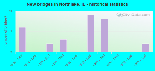
- New bridges - historical statistics
- 61900-1909
- 21920-1929
- 31930-1939
- 91950-1959
- 81960-1969
- 21990-1999

- Reconstructed bridges - Historical Statistics
- 11950-1959
- 01960-1969
- 01970-1979
- 11980-1989
- 01990-1999
- 12000-2009
- 02010-2019
- 12020-2022


- Bridge Condition - Deck
- 25.0%Excellent
- 12.5%Good
- 31.3%Satisfactory
- 6.3%Fair
- 12.5%Poor
- 6.3%Serious
- 6.3%Critical

- Bridge Condition - Superstructure
- 25.0%Excellent
- 6.3%Very good
- 18.8%Good
- 18.8%Satisfactory
- 12.5%Fair
- 6.3%Poor
- 6.3%Serious
- 6.3%Critical

- Bridge Condition - Substructure
- 43.8%Good
- 50.0%Satisfactory
- 6.3%Fair

- Bridge Condition - Channel
- 7.1%Excellent
- 21.4%Very good
- 42.9%Good
- 14.3%Satisfactory
- 14.3%Fair

- Bridge Condition - Culverts
- 33.3%Good
- 33.3%Satisfactory
- 33.3%Fair
Find on map >> Show street view
Structure Number: 16059, Location: 2 M N US 45 (Lat: 41.906736, Lng: -87.919608), Route carried "on" structure: US 20, Year Built: 1931, Status: Open, Structure Length: 9.15m (30.02ft), Average Daily Traffic: 11,350 (year 2021), Truck Traffic: 12%, Average Future Daily Traffic: 78,177 (year 2032), Design Load: HS 20, Features Intersected: IL 64 (NORTH AVE)
Minimum Vertical Clearance: 4.04m (13.25ft), Kilometerpoint: 266.452, Lanes on structure: 1, Lanes under structure: 5, Base Highway Network: Yes, Owner: State Highway Agency, Approaching Roadway Width: 7.9m (25.9ft), Skew: 6 degrees, Material/Design: Steel continuous, Design/Construction: Stringer/Multi-beam, Number Of Spans In Main Unit: 2, Length of Maximum Span: 40.5m (132.9ft), Curb-To-Curb Width: 7.9m (25.9ft), Out-to-Out Width: 8.9m (29.2ft)
Condition: Deck: Good, Superstructure: Good, Substructure: Good, Operating Rating: 81.3 metric tons, Method Used To Determine Operating Rating: Load Factor (LF) rating reported by rating factor (RF) method using MS18 loading, Inventory Rating: 48.9 metric tons, Method Used To Determine Inventory Rating: Load Factor (LF) rating reported by rating factor (RF) method using MS18 loading, Structural Evaluation: Better than present minimum criteria, Deck Geometry: High priority of corrective action, Underclear: High priority of corrective action, Approach Roadway Alignment: Equal to present desirable criteria, Length Of Structure Improvement: 8.56m (28.08ft), Designated Inspection Frequency: Every 24 months, Inspection Date: July 2021, Bridge Improvement Cost: $821,000, Roadway Improvement Cost: $82,000, Total Project Cost: $1,232,000, Deck Structure Type: Concrete Cast-file-Place, Wearing Surface/Protective System: Deck Protection: Epoxy Coated Reinforcing
Find on map >> Show street view
Structure Number: 162423, Location: 0.2 M N IL 64 (Lat: 41.910581, Lng: -87.903333), Route carried "on" structure: Other road , Year Built: 1932, Year Reconstructed: 1957, Status: Open, Structure Length: 1.37m (4.49ft), Average Daily Traffic: 11,300 (year 2018), Truck Traffic: 5%, Average Future Daily Traffic: 12,669 (year 2032), Features Intersected: ADDISON CREEK, Facility Carried by Structure: WOLF RD
Minimum Vertical Clearance: 30+ m (98+ ft), Kilometerpoint: 3.862, Lanes on structure: 4, Owner: State Highway Agency, Approaching Roadway Width: 15.8m (51.8ft), Skew: 4 degrees, Material/Design: Concrete continuous, Design/Construction: Culvert, Number Of Spans In Main Unit: 3, Length of Maximum Span: 4.3m (14.1ft), Curb or Sidewalk Widths: Left: 1.4m (4.6ft), Right: 1.4m (4.6ft), Curb-To-Curb Width: 16.5m (54.1ft), Out-to-Out Width: 30.2m (99.1ft)
Condition: Channel: Good, Culverts: Fair, Operating Rating: 76.5 metric tons, Method Used To Determine Operating Rating: Allowable Stress (AS) rating reported by rating factor (RF) method using MS18 loading, Inventory Rating: 53.1 metric tons, Method Used To Determine Inventory Rating: Allowable Stress (AS) rating reported by rating factor (RF) method using MS18 loading, Structural Evaluation: Somewhat better than minimum adequacy, Deck Geometry: Meets minimum limits, Waterway Adequacy: Equal to present desirable criteria, Approach Roadway Alignment: Equal to present desirable criteria, Designated Inspection Frequency: Every 24 months, Inspection Date: July 2020, Deck Structure Type: Other
Find on map >> Show street view
Structure Number: 162673, Location: 0.3 M W US 45 (Lat: 41.907278, Lng: -87.890733), Route carried "on" structure: State highway 64, Year Built: 1999, Status: Open, Structure Length: 1.08m (3.54ft), Average Daily Traffic: 41,700 (year 2021), Truck Traffic: 6%, Average Future Daily Traffic: 49,955 (year 2032), Features Intersected: ADDISON CREEK
Minimum Vertical Clearance: 30+ m (98+ ft), Kilometerpoint: 200.808, Lanes on structure: 6, Base Highway Network: Yes, Owner: State Highway Agency, Approaching Roadway Width: 40.6m (133.2ft), Skew: 30 degrees, Material/Design: Concrete, Design/Construction: Culvert, Number Of Spans In Main Unit: 3, Length of Maximum Span: 3.0m (9.8ft), Curb-To-Curb Width: 40.6m (133.2ft), Out-to-Out Width: 57.0m (187.0ft)
Condition: Channel: Very good, Culverts: Good, Operating Rating: 44.1 metric tons, Method Used To Determine Operating Rating: Load Factor (LF) rating reported by rating factor (RF) method using MS18 loading, Inventory Rating: 32.4 metric tons, Method Used To Determine Inventory Rating: Load Factor (LF) rating reported by rating factor (RF) method using MS18 loading, Structural Evaluation: Better than present minimum criteria, Deck Geometry: Superior to present desirable criteria, Waterway Adequacy: Equal to present desirable criteria, Approach Roadway Alignment: Equal to present desirable criteria, Designated Inspection Frequency: Every 24 months, Inspection Date: August 2020
Find on map >> Show street view
Structure Number: 162747, Location: .3 MI N. ILL RTE 64 (Lat: 41.911256, Lng: -87.919933), Route carried "on" structure: Interstate 294, Year Built: 1958, Year Reconstructed: 1991, Status: Open, Structure Length: 0.70m (2.30ft), Average Daily Traffic: 146,200 (year 2020), Truck Traffic: 15%, Average Future Daily Traffic: 156,354 (year 2032), Design Load: HS 20, Features Intersected: ADDISON CREEK
Minimum Vertical Clearance: 30+ m (98+ ft), Kilometerpoint: 30.545, Lanes on structure: 8, Base Highway Network: Yes, Toll: On toll road, Owner: State Toll Authority, Approaching Roadway Width: 44.5m (146.0ft), Material/Design: Concrete, Design/Construction: Culvert, Number Of Spans In Main Unit: 2, Length of Maximum Span: 3.0m (9.8ft)
Condition: Channel: Excellent, Culverts: Satisfactory, Operating Rating: 97.2 metric tons, Method Used To Determine Operating Rating: Load Factor (LF) rating reported by rating factor (RF) method using MS18 loading, Inventory Rating: 96.2 metric tons, Method Used To Determine Inventory Rating: Load Factor (LF) rating reported by rating factor (RF) method using MS18 loading, Structural Evaluation: Equal to present minimum criteria, Waterway Adequacy: Superior to present desirable criteria, Approach Roadway Alignment: Equal to present desirable criteria, Designated Inspection Frequency: Every 24 months, Inspection Date: May 2019, Deck Structure Type: Concrete Cast-file-Place
Find on map >> Show street view
Structure Number: 16761, Location: 0.1 M N NORTH P9 (Lat: 41.908472, Lng: -87.899475), Route carried "on" structure: City street , Year Built: 1965, Year Reconstructed: 2020, Status: Open, Structure Length: 1.71m (5.61ft), Average Daily Traffic: 200 (year 2018), Truck Traffic: 8%, Average Future Daily Traffic: 2,200 (year 2032), Design Load: HS 25 or greater, Features Intersected: ADDISON CR, Facility Carried by Structure: PRATER AVE
Minimum Vertical Clearance: 30+ m (98+ ft), Kilometerpoint: 1.046, Lanes on structure: 2, Owner: City or Municipal Highway Agency, Approaching Roadway Width: 9.0m (29.5ft), Material/Design: Prestressed concrete, Design/Construction: Box Beam or Girders - Multiple, Number Of Spans In Main Unit: 1, Length of Maximum Span: 15.8m (51.8ft), Curb or Sidewalk Widths: Left: 1.9m (6.2ft), Right: 1.9m (6.2ft), Curb-To-Curb Width: 9.0m (29.5ft), Out-to-Out Width: 13.4m (44.0ft)
Condition: Deck: Excellent, Superstructure: Excellent, Substructure: Good, Channel: Satisfactory, Operating Rating: 59.3 metric tons, Method Used To Determine Operating Rating: Load and Resistance Factor Rating (LRFR) rating reported by rating factor(RF) method using HL-93 loadings, Inventory Rating: 47.0 metric tons, Method Used To Determine Inventory Rating: Load and Resistance Factor Rating (LRFR) rating reported by rating factor(RF) method using HL-93 loadings, Structural Evaluation: Better than present minimum criteria, Deck Geometry: Equal to present minimum criteria, Waterway Adequacy: Better than present minimum criteria, Approach Roadway Alignment: Equal to present desirable criteria, Designated Inspection Frequency: Every 24 months, Inspection Date: October 2020, Deck Structure Type: Concrete Precast Panels, Wearing Surface/Protective System: Wearing Surface: Bituminous, Membrane: Built-up, Deck Protection: Epoxy Coated Reinforcing
Find on map >> Show street view
Structure Number: 167611, Location: 0.08 M N NORTH P9 (Lat: 41.908406, Lng: -87.891106), Route carried "on" structure: City street , Year Built: 1965, Status: Temporarily open, Structure Length: 1.83m (6.00ft), Average Daily Traffic: 125 (year 2018), Truck Traffic: 18%, Average Future Daily Traffic: 318 (year 2032), Design Load: H 15, Features Intersected: ADDISON CR, Facility Carried by Structure: PARKVIEW DR
Minimum Vertical Clearance: 30+ m (98+ ft), Kilometerpoint: 0.998, Lanes on structure: 2, Owner: City or Municipal Highway Agency, Approaching Roadway Width: 8.8m (28.9ft), Skew: 2 degrees, Material/Design: Prestressed concrete, Design/Construction: Box Beam or Girders - Multiple, Number Of Spans In Main Unit: 1, Length of Maximum Span: 17.7m (58.1ft), Curb or Sidewalk Widths: Left: 1.4m (4.6ft), Right: 1.4m (4.6ft), Curb-To-Curb Width: 9.1m (29.9ft), Out-to-Out Width: 12.3m (40.4ft)
Condition: Deck: Critical, Superstructure: Critical, Substructure: Good, Channel: Very good, Operating Rating: 7.8 metric tons, Method Used To Determine Operating Rating: Field evaluation and documented engineering judgment, Inventory Rating: 4.5 metric tons, Method Used To Determine Inventory Rating: Field evaluation and documented engineering judgment, Structural Evaluation: High priority of replacement, Deck Geometry: Equal to present minimum criteria, Waterway Adequacy: Equal to present minimum criteria, Approach Roadway Alignment: Equal to present desirable criteria, Bridge Posting: Required (Relationship of Operating Rating to Maximum Legal Load: > 39.9% below), Designated Inspection Frequency: Every 24 months, Other Special Inspection Frequency: Every 6 months, Inspection Date: October 2020, Other Special Inspection Date: October 2021, Deck Structure Type: Concrete Precast Panels, Wearing Surface/Protective System: Wearing Surface: Bituminous
Find on map >> Show street view
Structure Number: 167612, Location: 0.1 MI N NORTH AVE (Lat: 41.908731, Lng: -87.895992), Route carried "on" structure: Other road , Year Built: 1966, Year Reconstructed: 2021, Status: Open, Structure Length: 1.71m (5.61ft), Average Daily Traffic: 1,750 (year 2018), Truck Traffic: 6%, Average Future Daily Traffic: 1,700 (year 2032), Design Load: HS 25 or greater, Features Intersected: ADDISON CR, Facility Carried by Structure: ROY AVE
Minimum Vertical Clearance: 30+ m (98+ ft), Kilometerpoint: 1.513, Lanes on structure: 2, Owner: City or Municipal Highway Agency, Approaching Roadway Width: 9.0m (29.5ft), Material/Design: Prestressed concrete, Design/Construction: Box Beam or Girders - Multiple, Number Of Spans In Main Unit: 1, Length of Maximum Span: 16.5m (54.1ft), Curb or Sidewalk Widths: Left: 1.9m (6.2ft), Right: 1.9m (6.2ft), Curb-To-Curb Width: 9.0m (29.5ft), Out-to-Out Width: 13.4m (44.0ft)
Condition: Deck: Excellent, Superstructure: Excellent, Substructure: Satisfactory, Channel: Good, Operating Rating: 52.5 metric tons, Method Used To Determine Operating Rating: Load and Resistance Factor Rating (LRFR) rating reported by rating factor(RF) method using HL-93 loadings, Inventory Rating: 41.8 metric tons, Method Used To Determine Inventory Rating: Load and Resistance Factor Rating (LRFR) rating reported by rating factor(RF) method using HL-93 loadings, Structural Evaluation: Equal to present minimum criteria, Deck Geometry: Somewhat better than minimum adequacy, Waterway Adequacy: Better than present minimum criteria, Approach Roadway Alignment: Equal to present desirable criteria, Length Of Structure Improvement: 1.71m (5.61ft), Designated Inspection Frequency: Every 24 months, Inspection Date: July 2021, Bridge Improvement Cost: $108,000, Roadway Improvement Cost: $11,000, Total Project Cost: $162,000, Deck Structure Type: Concrete Precast Panels, Wearing Surface/Protective System: Wearing Surface: Integral Concrete, Deck Protection: Epoxy Coated Reinforcing
Find on map >> Show street view
Structure Number: 167613, Location: 0.08 M N NORTH P9 (Lat: 41.908206, Lng: -87.899833), Route carried "on" structure: City street , Year Built: 1954, Status: Open, Structure Length: 0.73m (2.40ft), Average Daily Traffic: 425 (year 2018), Truck Traffic: 6%, Average Future Daily Traffic: 318 (year 2032), Design Load: H 15, Features Intersected: ADDISON CR TRIB, Facility Carried by Structure: PARKVIEW DR
Minimum Vertical Clearance: 30+ m (98+ ft), Kilometerpoint: 0.209, Lanes on structure: 2, Owner: City or Municipal Highway Agency, Approaching Roadway Width: 7.8m (25.6ft), Skew: 2 degrees, Material/Design: Concrete, Design/Construction: Slab, Number Of Spans In Main Unit: 1, Length of Maximum Span: 6.9m (22.6ft), Curb or Sidewalk Widths: Left: 1.5m (4.9ft), Right: 1.5m (4.9ft), Curb-To-Curb Width: 9.2m (30.2ft), Out-to-Out Width: 12.8m (42.0ft)
Condition: Deck: Fair, Superstructure: Fair, Substructure: Fair, Channel: Fair, Operating Rating: 40.5 metric tons, Method Used To Determine Operating Rating: Field evaluation and documented engineering judgment, Inventory Rating: 24.3 metric tons, Method Used To Determine Inventory Rating: Field evaluation and documented engineering judgment, Structural Evaluation: Somewhat better than minimum adequacy, Deck Geometry: Equal to present minimum criteria, Waterway Adequacy: Equal to present minimum criteria, Approach Roadway Alignment: Equal to present desirable criteria, Designated Inspection Frequency: Every 24 months, Inspection Date: November 2020, Deck Structure Type: Concrete Cast-file-Place, Wearing Surface/Protective System: Wearing Surface: Bituminous
Find on map >> Show street view
Structure Number: 167614, Location: 0.13 MI N NORTH AV (Lat: 41.909058, Lng: -87.893542), Route carried "on" structure: Other road , Year Built: 1954, Status: Open, Structure Length: 1.18m (3.87ft), Average Daily Traffic: 975 (year 2018), Truck Traffic: 5%, Average Future Daily Traffic: 1,082 (year 2032), Design Load: H 15, Features Intersected: ADDISON CR, Facility Carried by Structure: ROBERTA AV
Minimum Vertical Clearance: 30+ m (98+ ft), Kilometerpoint: 2.414, Lanes on structure: 2, Owner: City or Municipal Highway Agency, Approaching Roadway Width: 8.8m (28.9ft), Material/Design: Concrete continuous, Design/Construction: Slab, Number Of Spans In Main Unit: 2, Length of Maximum Span: 5.8m (19.0ft), Curb or Sidewalk Widths: Left: 1.5m (4.9ft), Right: 1.5m (4.9ft), Curb-To-Curb Width: 10.2m (33.5ft), Out-to-Out Width: 13.7m (44.9ft)
Condition: Deck: Satisfactory, Superstructure: Satisfactory, Substructure: Satisfactory, Channel: Good, Operating Rating: 47.6 metric tons, Method Used To Determine Operating Rating: Load Factor (LF) rating reported by rating factor (RF) method using MS18 loading, Inventory Rating: 28.5 metric tons, Method Used To Determine Inventory Rating: Load Factor (LF) rating reported by rating factor (RF) method using MS18 loading, Structural Evaluation: Equal to present minimum criteria, Deck Geometry: Equal to present minimum criteria, Waterway Adequacy: Equal to present minimum criteria, Approach Roadway Alignment: Equal to present desirable criteria, Designated Inspection Frequency: Every 24 months, Inspection Date: November 2020, Deck Structure Type: Concrete Cast-file-Place, Wearing Surface/Protective System: Wearing Surface: Bituminous
Find on map >> Show street view
Structure Number: 167615, Location: 0.3 M S NORTH P20 (Lat: 41.903217, Lng: -87.890406), Route carried "on" structure: Other road , Year Built: 1960, Status: Open, Structure Length: 1.81m (5.94ft), Average Daily Traffic: 1,300 (year 2018), Truck Traffic: 6%, Average Future Daily Traffic: 1,442 (year 2032), Design Load: HS 15, Features Intersected: ADDISON CR, Facility Carried by Structure: FAU 1033 (HIRSCH S
Minimum Vertical Clearance: 30+ m (98+ ft), Kilometerpoint: 0.451, Lanes on structure: 2, Owner: City or Municipal Highway Agency, Approaching Roadway Width: 8.9m (29.2ft), Skew: 1 degrees, Material/Design: Prestressed concrete, Design/Construction: Box Beam or Girders - Multiple, Number Of Spans In Main Unit: 1, Length of Maximum Span: 17.5m (57.4ft), Curb or Sidewalk Widths: Left: 1.4m (4.6ft), Right: 1.4m (4.6ft), Curb-To-Curb Width: 8.9m (29.2ft), Out-to-Out Width: 12.1m (39.7ft)
Condition: Deck: Serious, Superstructure: Serious, Substructure: Good, Channel: Fair, Operating Rating: 43.1 metric tons, Method Used To Determine Operating Rating: Load Factor (LF) rating reported by rating factor (RF) method using MS18 loading, Inventory Rating: 18.8 metric tons, Method Used To Determine Inventory Rating: Load Factor (LF) rating reported by rating factor (RF) method using MS18 loading, Structural Evaluation: High priority of corrective action, Deck Geometry: Somewhat better than minimum adequacy, Waterway Adequacy: Equal to present minimum criteria, Approach Roadway Alignment: Equal to present desirable criteria, Designated Inspection Frequency: Every 24 months, Inspection Date: July 2020, Deck Structure Type: Concrete Precast Panels, Wearing Surface/Protective System: Wearing Surface: Bituminous
Find on map >> Show street view
Structure Number: 167616, Location: 0.14 M S NORTH AVE (Lat: 41.905356, Lng: -87.890514), Route carried "on" structure: Other road , Year Built: 1960, Year Reconstructed: 2021, Status: Open, Structure Length: 1.83m (6.00ft), Average Daily Traffic: 650 (year 2018), Truck Traffic: 6%, Average Future Daily Traffic: 670 (year 2032), Design Load: HS 25 or greater, Features Intersected: ADDISON CR, Facility Carried by Structure: LEMOYNE ST
Minimum Vertical Clearance: 30+ m (98+ ft), Kilometerpoint: 1.175, Lanes on structure: 2, Owner: City or Municipal Highway Agency, Approaching Roadway Width: 8.1m (26.6ft), Skew: 2 degrees, Material/Design: Prestressed concrete, Design/Construction: Box Beam or Girders - Multiple, Number Of Spans In Main Unit: 1, Length of Maximum Span: 17.1m (56.1ft), Curb or Sidewalk Widths: Left: 1.8m (5.9ft), Right: 1.8m (5.9ft), Curb-To-Curb Width: 8.7m (28.5ft), Out-to-Out Width: 12.7m (41.7ft)
Condition: Deck: Excellent, Superstructure: Excellent, Substructure: Satisfactory, Channel: Good, Operating Rating: 65.1 metric tons, Method Used To Determine Operating Rating: Load and Resistance Factor Rating (LRFR) rating reported by rating factor(RF) method using HL-93 loadings, Inventory Rating: 51.2 metric tons, Method Used To Determine Inventory Rating: Load and Resistance Factor Rating (LRFR) rating reported by rating factor(RF) method using HL-93 loadings, Structural Evaluation: Equal to present minimum criteria, Deck Geometry: Somewhat better than minimum adequacy, Waterway Adequacy: Equal to present minimum criteria, Approach Roadway Alignment: Equal to present desirable criteria, Designated Inspection Frequency: Every 24 months, Inspection Date: July 2021, Deck Structure Type: Concrete Precast Panels, Wearing Surface/Protective System: Wearing Surface: Bituminous, Membrane: Built-up
Find on map >> Show street view
Structure Number: 167617, Location: 0.15 MI N FULLERTON (Lat: 41.923436, Lng: -87.910744), Route carried "on" structure: City street , Year Built: 1991, Year Reconstructed: 2021, Status: Open, Structure Length: 2.41m (7.91ft), Average Daily Traffic: 2,850 (year 2018), Truck Traffic: 4%, Average Future Daily Traffic: 2,069 (year 2032), Design Load: HS 25 or greater, Features Intersected: ADDISON CREEK, Facility Carried by Structure: King Arthur Court
Minimum Vertical Clearance: 30+ m (98+ ft), Kilometerpoint: 0.177, Lanes on structure: 2, Owner: City or Municipal Highway Agency, Approaching Roadway Width: 7.3m (24.0ft), Skew: 1 degrees, Material/Design: Prestressed concrete, Design/Construction: Box Beam or Girders - Multiple, Number Of Spans In Main Unit: 2, Length of Maximum Span: 11.2m (36.7ft), Curb or Sidewalk Widths: Left: 2.0m (6.6ft), Right: 2.0m (6.6ft), Curb-To-Curb Width: 9.4m (30.8ft), Out-to-Out Width: 14.6m (47.9ft)
Condition: Deck: Excellent, Superstructure: Excellent, Substructure: Good, Channel: Good, Operating Rating: 64.5 metric tons, Method Used To Determine Operating Rating: Load and Resistance Factor Rating (LRFR) rating reported by rating factor(RF) method using HL-93 loadings, Inventory Rating: 49.9 metric tons, Method Used To Determine Inventory Rating: Load and Resistance Factor Rating (LRFR) rating reported by rating factor(RF) method using HL-93 loadings, Structural Evaluation: Better than present minimum criteria, Deck Geometry: Meets minimum limits, Waterway Adequacy: Better than present minimum criteria, Approach Roadway Alignment: Equal to present minimum criteria, Designated Inspection Frequency: Every 24 months, Inspection Date: July 2021, Deck Structure Type: Concrete Precast Panels, Wearing Surface/Protective System: Wearing Surface: Integral Concrete, Deck Protection: Epoxy Coated Reinforcing
Find on map >> Show street view
Structure Number: 167618, Location: W OF WOLF RD (Lat: 41.912119, Lng: -87.906289), Route carried "on" structure: City street , Year Built: 1961, Year Reconstructed: 2011, Status: Open, Structure Length: 1.05m (3.44ft), Average Daily Traffic: 650 (year 2018), Truck Traffic: 29%, Average Future Daily Traffic: 412 (year 2032), Design Load: HS 20, Features Intersected: ADDISON CREEK, Facility Carried by Structure: MS-4025 WHITEHALL
Minimum Vertical Clearance: 30+ m (98+ ft), Kilometerpoint: 0.467, Lanes on structure: 3, Owner: City or Municipal Highway Agency, Approaching Roadway Width: 10.2m (33.5ft), Material/Design: Steel, Design/Construction: Stringer/Multi-beam, Number Of Spans In Main Unit: 1, Length of Maximum Span: 9.5m (31.2ft), Curb or Sidewalk Widths: Left: 1.5m (4.9ft), Right: 0.0m, Curb-To-Curb Width: 10.1m (33.1ft), Out-to-Out Width: 12.4m (40.7ft)
Condition: Deck: Good, Superstructure: Very good, Substructure: Good, Channel: Very good, Operating Rating: 71.0 metric tons, Method Used To Determine Operating Rating: Load Factor (LF) rating reported by rating factor (RF) method using MS18 loading, Inventory Rating: 42.4 metric tons, Method Used To Determine Inventory Rating: Load Factor (LF) rating reported by rating factor (RF) method using MS18 loading, Structural Evaluation: Better than present minimum criteria, Deck Geometry: High priority of replacement, Waterway Adequacy: Superior to present desirable criteria, Approach Roadway Alignment: Equal to present desirable criteria, Designated Inspection Frequency: Every 48 months, Inspection Date: July 2018, Deck Structure Type: Concrete Cast-file-Place, Wearing Surface/Protective System: Deck Protection: Epoxy Coated Reinforcing
Find on map >> Show street view
Structure Number: 167619, Location: 0.1 MI W WOLF RD (Lat: 41.914167, Lng: -87.905292), Route carried "on" structure: City street , Year Built: 1961, Status: Posted for load, Structure Length: 1.05m (3.44ft), Average Daily Traffic: 175 (year 2018), Truck Traffic: 5%, Average Future Daily Traffic: 412 (year 2032), Features Intersected: Addison Creek, Facility Carried by Structure: MS4023 (Armitage A
Minimum Vertical Clearance: 30+ m (98+ ft), Kilometerpoint: 0.129, Lanes on structure: 2, Owner: City or Municipal Highway Agency, Approaching Roadway Width: 6.7m (22.0ft), Material/Design: Steel, Design/Construction: Stringer/Multi-beam, Number Of Spans In Main Unit: 1, Length of Maximum Span: 10.4m (34.1ft), Curb or Sidewalk Widths: Left: 0.0m, Right: 1.2m (3.9ft), Curb-To-Curb Width: 6.7m (22.0ft), Out-to-Out Width: 8.8m (28.9ft)
Condition: Deck: Poor, Superstructure: Fair, Substructure: Satisfactory, Channel: Good, Operating Rating: 34.0 metric tons, Method Used To Determine Operating Rating: Load Factor (LF) rating reported by rating factor (RF) method using MS18 loading, Inventory Rating: 20.4 metric tons, Method Used To Determine Inventory Rating: Load Factor (LF) rating reported by rating factor (RF) method using MS18 loading, Structural Evaluation: Somewhat better than minimum adequacy, Deck Geometry: Meets minimum limits, Waterway Adequacy: Equal to present minimum criteria, Approach Roadway Alignment: Equal to present desirable criteria, Bridge Posting: Required (Relationship of Operating Rating to Maximum Legal Load: > 39.9% below), Designated Inspection Frequency: Every 24 months, Inspection Date: October 2021, Deck Structure Type: Concrete Cast-file-Place, Wearing Surface/Protective System: Wearing Surface: Bituminous
Find on map >> Show street view
Structure Number: 16762, Location: 0.1 MI W WOLF RD (Lat: 41.917828, Lng: -87.906894), Route carried "on" structure: City street , Year Built: 1961, Status: Open, Structure Length: 1.05m (3.44ft), Average Daily Traffic: 400 (year 2000), Average Future Daily Traffic: 412 (year 2032), Features Intersected: ADDISON CREEK, Facility Carried by Structure: PALMER AV
Minimum Vertical Clearance: 30+ m (98+ ft), Kilometerpoint: 0.612, Lanes on structure: 3, Owner: City or Municipal Highway Agency, Approaching Roadway Width: 10.1m (33.1ft), Material/Design: Steel, Design/Construction: Stringer/Multi-beam, Number Of Spans In Main Unit: 1, Length of Maximum Span: 10.5m (34.4ft), Curb or Sidewalk Widths: Left: 0.0m, Right: 1.2m (3.9ft), Curb-To-Curb Width: 10.1m (33.1ft), Out-to-Out Width: 11.9m (39.0ft)
Condition: Deck: Poor, Superstructure: Poor, Substructure: Satisfactory, Channel: Satisfactory, Operating Rating: 39.5 metric tons, Method Used To Determine Operating Rating: Load Factor (LF) rating reported by rating factor (RF) method using MS18 loading, Inventory Rating: 23.7 metric tons, Method Used To Determine Inventory Rating: Load Factor (LF) rating reported by rating factor (RF) method using MS18 loading, Structural Evaluation: Meets minimum limits, Deck Geometry: High priority of replacement, Waterway Adequacy: Equal to present minimum criteria, Approach Roadway Alignment: Equal to present minimum criteria, Designated Inspection Frequency: Every 24 months, Inspection Date: October 2021, Deck Structure Type: Other, Wearing Surface/Protective System: Wearing Surface: Bituminous
Find on map >> Show street view
Structure Number: 16979, Location: 2.3 M N ILL 56 P20 (Lat: 41.907311, Lng: -87.919961), Route carried "on" structure: Interstate 294, Year Built: 1958, Status: Open, Structure Length: 8.08m (26.51ft), Average Daily Traffic: 73,100 (year 2020), Truck Traffic: 15%, Average Future Daily Traffic: 78,177 (year 2032), Features Intersected: US 20,IL-64 & RAMP
Minimum Vertical Clearance: 30+ m (98+ ft), Kilometerpoint: 30.979, Lanes on structure: 3, Lanes under structure: 6, Base Highway Network: Yes, Toll: On toll road, Owner: State Toll Authority, Approaching Roadway Width: 15.8m (51.8ft), Material/Design: Steel, Design/Construction: Stringer/Multi-beam, Number Of Spans In Main Unit: 3, Length of Maximum Span: 40.8m (133.9ft), Curb-To-Curb Width: 14.2m (46.6ft), Out-to-Out Width: 21.0m (68.9ft)
Condition: Deck: Satisfactory, Superstructure: Satisfactory, Substructure: Satisfactory, Operating Rating: 64.5 metric tons, Method Used To Determine Operating Rating: Load Factor (LF) rating reported by rating factor (RF) method using MS18 loading, Inventory Rating: 38.6 metric tons, Method Used To Determine Inventory Rating: Load Factor (LF) rating reported by rating factor (RF) method using MS18 loading, Structural Evaluation: Equal to present minimum criteria, Deck Geometry: Meets minimum limits, Underclear: High priority of corrective action, Approach Roadway Alignment: Equal to present desirable criteria, Designated Inspection Frequency: Every 24 months, Inspection Date: May 2020, Deck Structure Type: Concrete Cast-file-Place, Wearing Surface/Protective System: Wearing Surface: Bituminous, Membrane: Built-up
Find on map >> Show street view
Structure Number: 169791, Location: 2.3 M N ILL 38 P20 (Lat: 41.907164, Lng: -87.919964), Route carried "on" structure: Interstate 294, Year Built: 1958, Status: Open, Structure Length: 8.08m (26.51ft), Average Daily Traffic: 73,100 (year 2020), Truck Traffic: 15%, Average Future Daily Traffic: 78,177 (year 2032), Features Intersected: ILL 64, US 20& RAMP
Minimum Vertical Clearance: 30+ m (98+ ft), Kilometerpoint: 30.995, Lanes on structure: 3, Lanes under structure: 6, Base Highway Network: Yes, Toll: On toll road, Owner: State Toll Authority, Approaching Roadway Width: 15.8m (51.8ft), Material/Design: Steel, Design/Construction: Stringer/Multi-beam, Number Of Spans In Main Unit: 3, Length of Maximum Span: 40.8m (133.9ft), Curb-To-Curb Width: 14.2m (46.6ft), Out-to-Out Width: 18.6m (61.0ft)
Condition: Deck: Satisfactory, Superstructure: Satisfactory, Substructure: Satisfactory, Operating Rating: 63.8 metric tons, Method Used To Determine Operating Rating: Load Factor (LF) rating reported by rating factor (RF) method using MS18 loading, Inventory Rating: 38.2 metric tons, Method Used To Determine Inventory Rating: Load Factor (LF) rating reported by rating factor (RF) method using MS18 loading, Structural Evaluation: Equal to present minimum criteria, Deck Geometry: Meets minimum limits, Approach Roadway Alignment: Equal to present desirable criteria, Designated Inspection Frequency: Every 24 months, Inspection Date: May 2020, Deck Structure Type: Concrete Cast-file-Place, Wearing Surface/Protective System: Wearing Surface: Bituminous, Membrane: Built-up
Find on map >> Show street view
Structure Number: 169792, Location: 0.4 M S US 20 P20 (Lat: 41.900142, Lng: -87.920008), Route carried "on" structure: Interstate 294, Year Built: 1958, Status: Open, Structure Length: 3.87m (12.70ft), Average Daily Traffic: 62,550 (year 2020), Truck Traffic: 15%, Average Future Daily Traffic: 65,199 (year 2032), Features Intersected: C&NW RR
Minimum Vertical Clearance: 30+ m (98+ ft), Kilometerpoint: 31.768, Lanes on structure: 3, Base Highway Network: Yes, Toll: On toll road, Owner: State Toll Authority, Approaching Roadway Width: 15.8m (51.8ft), Skew: 6 degrees, Material/Design: Steel, Design/Construction: Stringer/Multi-beam, Number Of Spans In Main Unit: 1, Length of Maximum Span: 37.8m (124.0ft), Curb-To-Curb Width: 14.2m (46.6ft), Out-to-Out Width: 18.6m (61.0ft)
Condition: Deck: Satisfactory, Superstructure: Good, Substructure: Good, Operating Rating: 97.2 metric tons, Method Used To Determine Operating Rating: Load Factor (LF) rating reported by rating factor (RF) method using MS18 loading, Inventory Rating: 60.3 metric tons, Method Used To Determine Inventory Rating: Load Factor (LF) rating reported by rating factor (RF) method using MS18 loading, Structural Evaluation: Better than present minimum criteria, Deck Geometry: Meets minimum limits, Underclear: Equal to present desirable criteria, Approach Roadway Alignment: Equal to present desirable criteria, Designated Inspection Frequency: Every 24 months, Inspection Date: April 2021, Deck Structure Type: Concrete Cast-file-Place, Wearing Surface/Protective System: Wearing Surface: Bituminous, Membrane: Built-up
Find on map >> Show street view
Structure Number: 169793, Location: 0.4 M S US 20 P20 (Lat: 41.899994, Lng: -87.920008), Route carried "on" structure: Interstate 294, Year Built: 1958, Status: Open, Structure Length: 3.87m (12.70ft), Average Daily Traffic: 62,550 (year 2020), Truck Traffic: 15%, Average Future Daily Traffic: 65,199 (year 2032), Features Intersected: C&NW RR
Minimum Vertical Clearance: 30+ m (98+ ft), Kilometerpoint: 31.784, Lanes on structure: 3, Base Highway Network: Yes, Toll: On toll road, Owner: State Toll Authority, Approaching Roadway Width: 15.8m (51.8ft), Skew: 6 degrees, Material/Design: Steel, Design/Construction: Stringer/Multi-beam, Number Of Spans In Main Unit: 1, Length of Maximum Span: 37.8m (124.0ft), Curb-To-Curb Width: 14.2m (46.6ft), Out-to-Out Width: 18.6m (61.0ft)
Condition: Deck: Satisfactory, Superstructure: Good, Substructure: Satisfactory, Operating Rating: 97.2 metric tons, Method Used To Determine Operating Rating: Load Factor (LF) rating reported by rating factor (RF) method using MS18 loading, Inventory Rating: 81.3 metric tons, Method Used To Determine Inventory Rating: Load Factor (LF) rating reported by rating factor (RF) method using MS18 loading, Structural Evaluation: Equal to present minimum criteria, Deck Geometry: Meets minimum limits, Underclear: Equal to present desirable criteria, Approach Roadway Alignment: Equal to present desirable criteria, Designated Inspection Frequency: Every 24 months, Inspection Date: April 2021, Deck Structure Type: Concrete Cast-file-Place, Wearing Surface/Protective System: Wearing Surface: Bituminous, Membrane: Built-up
Find on map >> Show street view
Structure Number: 160495, Location: 1.66 M W US 45 P9,20 (Lat: 41.906789, Lng: -87.915961), Route carried "under" structure: State highway 64, Year Built: 1900, Structure Length: 0. m, Average Daily Traffic: 44,100 (year 2021), Truck Traffic: 8%, Features Intersected: ILL 64 (NORTH AVE), Facility Carried by Structure: C&NW RR
Minimum Vertical Clearance: 4.50m (14.76ft), Kilometerpoint: 198.716, Lanes under structure: 6, Material/Design: Steel, Length of Maximum Span: 20.1m (65.9ft)
Find on map >> Show street view
Structure Number: 160496, Location: 1.64 M W US 45 P9,20 (Lat: 41.906797, Lng: -87.915653), Route carried "under" structure: State highway 64, Year Built: 1900, Structure Length: 0. m, Average Daily Traffic: 44,100 (year 2021), Truck Traffic: 8%, Features Intersected: ILL 64 (NORTH AVE), Facility Carried by Structure: C&NW RR
Minimum Vertical Clearance: 4.27m (14.01ft), Kilometerpoint: 198.732, Lanes under structure: 6, Material/Design: Steel, Length of Maximum Span: 18.6m (61.0ft)
Find on map >> Show street view
Structure Number: 160497, Location: 1.63 M W US 45 P9,20 (Lat: 41.906800, Lng: -87.915514), Route carried "under" structure: State highway 64, Year Built: 1900, Structure Length: 0. m, Average Daily Traffic: 44,100 (year 2021), Truck Traffic: 8%, Features Intersected: ILL 64 (NORTH AVE), Facility Carried by Structure: C&NW RR
Minimum Vertical Clearance: 5.23m (17.16ft), Kilometerpoint: 198.749, Lanes under structure: 6, Material/Design: Steel, Length of Maximum Span: 18.9m (62.0ft)
Find on map >> Show street view
Structure Number: 160498, Location: 1.61 M W US 45 P9,20 (Lat: 41.906803, Lng: -87.915358), Route carried "under" structure: State highway 64, Year Built: 1900, Structure Length: 0. m, Average Daily Traffic: 44,100 (year 2021), Truck Traffic: 8%, Features Intersected: ILL 64 (NORTH AVE), Facility Carried by Structure: C&NW RR
Minimum Vertical Clearance: 4.57m (14.99ft), Kilometerpoint: 198.765, Lanes under structure: 6, Material/Design: Steel, Length of Maximum Span: 18.9m (62.0ft)
Find on map >> Show street view
Structure Number: 16059, Location: 2 M N US 45 (Lat: 41.906736, Lng: -87.919608), Route carried "under" structure: State highway 64, Year Built: 1931, Structure Length: 0. m, Average Daily Traffic: 44,100 (year 2021), Truck Traffic: 8%, Features Intersected: IL 64 (NORTH AVE), Facility Carried by Structure: US 20 WB (LAKE ST)
Minimum Vertical Clearance: 4.70m (15.42ft), Kilometerpoint: 198.411, Lanes on structure: 1, Lanes under structure: 5, Material/Design: Steel continuous, Design/Construction: Stringer/Multi-beam, Length of Maximum Span: 40.5m (132.9ft)
Find on map >> Show street view
Structure Number: 160591, Location: 1.81 M W US 45 P20 (Lat: 41.905914, Lng: -87.916456), Route carried "under" structure: US 20, Year Built: 1900, Structure Length: 0. m, Average Daily Traffic: 22,700 (year 2021), Truck Traffic: 12%, Features Intersected: US 20 (LAKE ST), Facility Carried by Structure: C&NW RR
Minimum Vertical Clearance: 4.42m (14.50ft), Kilometerpoint: 266.725, Lanes under structure: 4, Material/Design: Steel, Design/Construction: Girder and Floorbeam System, Length of Maximum Span: 22.9m (75.1ft)
Find on map >> Show street view
Structure Number: 160592, Location: 1.77 M W US 45 P20 (Lat: 41.905736, Lng: -87.915756), Route carried "under" structure: US 20, Year Built: 1927, Structure Length: 0. m, Average Daily Traffic: 22,700 (year 2021), Truck Traffic: 12%, Features Intersected: US 20 (LAKE ST), Facility Carried by Structure: C&NW RR
Minimum Vertical Clearance: 4.50m (14.76ft), Kilometerpoint: 266.790, Lanes under structure: 4, Material/Design: Steel, Design/Construction: Girder and Floorbeam System, Length of Maximum Span: 23.2m (76.1ft)
Find on map >> Show street view
Structure Number: 160593, Location: 1.76 M W US 45 P20 (Lat: 41.905703, Lng: -87.915628), Route carried "under" structure: US 20, Year Built: 1900, Structure Length: 0. m, Average Daily Traffic: 22,700 (year 2021), Truck Traffic: 12%, Features Intersected: US 20 (LAKE ST), Facility Carried by Structure: C&NW RR
Minimum Vertical Clearance: 5.64m (18.50ft), Kilometerpoint: 266.806, Lanes under structure: 4, Material/Design: Steel, Design/Construction: Girder and Floorbeam System, Length of Maximum Span: 23.5m (77.1ft)
Find on map >> Show street view
Structure Number: 160594, Location: 1.75 M W US 45 P20 (Lat: 41.905653, Lng: -87.915433), Route carried "under" structure: US 20, Year Built: 1927, Structure Length: 0. m, Average Daily Traffic: 22,700 (year 2021), Truck Traffic: 12%, Features Intersected: US 20 (LAKE ST), Facility Carried by Structure: C&NW RR
Minimum Vertical Clearance: 4.39m (14.40ft), Kilometerpoint: 266.822, Lanes under structure: 4, Material/Design: Steel, Design/Construction: Girder and Floorbeam System, Length of Maximum Span: 22.6m (74.1ft)
Find on map >> Show street view
Structure Number: 16979, Location: 2.3 M N ILL 56 P20 (Lat: 41.906733, Lng: -87.919975), Route carried "under" structure: US 20, Year Built: 1958, Structure Length: 0. m, Average Daily Traffic: 44,100 (year 2021), Truck Traffic: 8%, Features Intersected: US 20,IL-64 & RAMP, Facility Carried by Structure: I-294 SB
Minimum Vertical Clearance: 5.89m (19.32ft), Kilometerpoint: 266.436, Lanes on structure: 3, Lanes under structure: 6, Toll: On toll road, Material/Design: Steel, Design/Construction: Stringer/Multi-beam, Length of Maximum Span: 40.8m (133.9ft)
Find on map >> Show street view
Structure Number: 169791, Location: 2.3 M N ILL 38 P20 (Lat: 41.906736, Lng: -87.919608), Route carried "under" structure: State highway 64, Year Built: 1958, Structure Length: 0. m, Average Daily Traffic: 44,100 (year 2021), Truck Traffic: 8%, Features Intersected: ILL 64, US 20& RAMP, Facility Carried by Structure: I-294 NB
Minimum Vertical Clearance: 5.89m (19.32ft), Kilometerpoint: 198.411, Lanes on structure: 3, Lanes under structure: 6, Toll: On toll road, Material/Design: Steel, Design/Construction: Stringer/Multi-beam, Length of Maximum Span: 40.8m (133.9ft)