Bridge Statistics for Northlake, Texas (TX)
Condition, Traffic, Stress, Structural Evaluation, Project Costs
- National Bridge Inventory (NBI) Statistics
- 40Number of bridges
- 679ft / 207mTotal length
- $263,000Total costs
- 537,416Total average daily traffic
- 70,859Total average daily truck traffic
- National Bridge Inventory (NBI) Registered Bridges for Northlake
- No street view available for this location
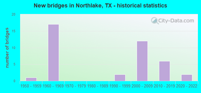
- New bridges - historical statistics
- 11950-1959
- 171960-1969
- 21990-1999
- 122000-2009
- 62010-2019
- 22020-2022

- Reconstructed bridges - Historical Statistics
- 11990-1999
- 12000-2009


- Bridge Condition - Deck
- 4.3%Excellent
- 8.7%Very good
- 56.5%Good
- 26.1%Satisfactory
- 4.3%Fair

- Bridge Condition - Superstructure
- 26.1%Very good
- 60.9%Good
- 8.7%Satisfactory
- 4.3%Fair

- Bridge Condition - Substructure
- 4.3%Very good
- 60.9%Good
- 34.8%Satisfactory

- Bridge Condition - Channel
- 16.7%Very good
- 36.7%Good
- 36.7%Satisfactory
- 10.0%Fair

- Bridge Condition - Culverts
- 8.3%Very good
- 75.0%Good
- 16.7%Satisfactory
Find on map >> Show street view
Structure Number: 18061000811307, Location: 0.10 MI N OF SH 114 (Lat: 33.026842, Lng: -97.273533), Route carried "on" structure: Interstate 35, Year Built: 1966, Year Reconstructed: 2001, Status: Open, Structure Length: 1.19m (3.90ft), Average Daily Traffic: 44,342 (year 2020), Truck Traffic: 14%, Average Future Daily Traffic: 49,620 (year 2033), Design Load: HS 20, Features Intersected: PETERSONS DRAW
Minimum Vertical Clearance: 30+ m (98+ ft), Kilometerpoint: 5.100, Lanes on structure: 15, Owner: State Highway Agency, Approaching Roadway Width: 83.2m (273.0ft), Skew: 29 degrees, Material/Design: Concrete, Design/Construction: Culvert, Number Of Spans In Main Unit: 4, Length of Maximum Span: 3.0m (9.8ft)
Condition: Channel: Very good, Culverts: Satisfactory, Operating Rating: 39.9 metric tons, Method Used To Determine Operating Rating: Load Factor (LF), Inventory Rating: 23.6 metric tons, Method Used To Determine Inventory Rating: Load Factor (LF), Structural Evaluation: Somewhat better than minimum adequacy, Waterway Adequacy: Superior to present desirable criteria, Approach Roadway Alignment: Equal to present desirable criteria, Designated Inspection Frequency: Every 24 months, Inspection Date: September 2021
Find on map >> Show street view
Structure Number: 180610008113114, Location: 1.50 MI S OF FM 407 (Lat: 33.079753, Lng: -97.235581), Route carried "on" structure: City street 35, Year Built: 1969, Status: Open, Structure Length: 12.19m (39.99ft), Average Daily Traffic: 150 (year 2013), Average Future Daily Traffic: 43,956 (year 2028), Design Load: HS 20, Features Intersected: IH 35W, Facility Carried by Structure: CLEVELAND ROAD
Minimum Vertical Clearance: 30+ m (98+ ft), Kilometerpoint: 11.806, Lanes on structure: 2, Lanes under structure: 4, Owner: State Highway Agency, Approaching Roadway Width: 7.9m (25.9ft), Skew: 24 degrees, Material/Design: Steel continuous, Design/Construction: Stringer/Multi-beam, Number Of Spans In Main Unit: 2, Number Of Approach Spans: 4, Length of Maximum Span: 29.0m (95.1ft), Curb-To-Curb Width: 7.9m (25.9ft), Out-to-Out Width: 8.5m (27.9ft)
Condition: Deck: Good, Superstructure: Satisfactory, Substructure: Good, Operating Rating: 44.4 metric tons, Method Used To Determine Operating Rating: Load Factor (LF), Inventory Rating: 26.3 metric tons, Method Used To Determine Inventory Rating: Load Factor (LF), Structural Evaluation: Equal to present minimum criteria, Deck Geometry: Somewhat better than minimum adequacy, Underclear: Somewhat better than minimum adequacy, Approach Roadway Alignment: Equal to present desirable criteria, Designated Inspection Frequency: Every 24 months, Inspection Date: August 2021, Deck Structure Type: Concrete Cast-file-Place
Find on map >> Show street view
Structure Number: 180610008113115, Location: 2.69 MI S OF FM 407 (Lat: 33.064725, Lng: -97.242497), Route carried "on" structure: State highway 35, Year Built: 1969, Status: Open, Structure Length: 9.30m (30.51ft), Average Daily Traffic: 7,000 (year 2013), Truck Traffic: 13%, Average Future Daily Traffic: 9,800 (year 2033), Design Load: H 15, Features Intersected: IH 35W, Facility Carried by Structure: FM 1171
Minimum Vertical Clearance: 30+ m (98+ ft), Kilometerpoint: 12.258, Lanes on structure: 2, Lanes under structure: 4, Owner: State Highway Agency, Approaching Roadway Width: 7.9m (25.9ft), Skew: 22 degrees, Material/Design: Prestressed concrete, Design/Construction: Stringer/Multi-beam, Number Of Spans In Main Unit: 4, Length of Maximum Span: 24.4m (80.1ft), Curb-To-Curb Width: 7.9m (25.9ft), Out-to-Out Width: 8.6m (28.2ft)
Condition: Deck: Good, Superstructure: Good, Substructure: Good, Operating Rating: 51.7 metric tons, Method Used To Determine Operating Rating: Load Factor (LF), Inventory Rating: 19.0 metric tons, Method Used To Determine Inventory Rating: Load Factor (LF), Structural Evaluation: Meets minimum limits, Deck Geometry: High priority of corrective action, Underclear: Somewhat better than minimum adequacy, Approach Roadway Alignment: Equal to present desirable criteria, Length Of Structure Improvement: 9.30m (30.51ft), Designated Inspection Frequency: Every 24 months, Inspection Date: August 2021, Bridge Improvement Cost: $16,000, Roadway Improvement Cost: $4,000, Total Project Cost: $20,000, Deck Structure Type: Concrete Cast-file-Place
Find on map >> Show street view
Structure Number: 180610008113116, Location: 1.00 MI S OF FM 1171 (Lat: 33.052228, Lng: -97.251231), Route carried "on" structure: Interstate 35, Year Built: 1969, Status: Open, Structure Length: 8.50m (27.89ft), Average Daily Traffic: 24,816 (year 2019), Truck Traffic: 14%, Average Future Daily Traffic: 24,810 (year 2033), Design Load: HS 20, Features Intersected: DENTON CRK
Minimum Vertical Clearance: 30+ m (98+ ft), Kilometerpoint: 8.497, Lanes on structure: 2, Owner: State Highway Agency, Approaching Roadway Width: 12.2m (40.0ft), Skew: 2 degrees, Material/Design: Steel continuous, Design/Construction: Stringer/Multi-beam, Number Of Spans In Main Unit: 3, Number Of Approach Spans: 2, Length of Maximum Span: 22.9m (75.1ft), Curb-To-Curb Width: 9.9m (32.5ft), Out-to-Out Width: 10.8m (35.4ft)
Condition: Deck: Satisfactory, Superstructure: Good, Substructure: Satisfactory, Channel: Good, Operating Rating: 50.8 metric tons, Method Used To Determine Operating Rating: Load Factor (LF), Inventory Rating: 30.8 metric tons, Method Used To Determine Inventory Rating: Load Factor (LF), Structural Evaluation: Equal to present minimum criteria, Deck Geometry: Meets minimum limits, Waterway Adequacy: Equal to present minimum criteria, Approach Roadway Alignment: Equal to present desirable criteria, Length Of Structure Improvement: 8.50m (27.89ft), Designated Inspection Frequency: Every 24 months, Inspection Date: September 2021, Bridge Improvement Cost: $184,000, Roadway Improvement Cost: $46,000, Total Project Cost: $230,000, Deck Structure Type: Concrete Cast-file-Place, Wearing Surface/Protective System: Wearing Surface: Bituminous
Find on map >> Show street view
Structure Number: 180610008113117, Location: 1.00 MI S OF FM 1171 (Lat: 33.052381, Lng: -97.250839), Route carried "on" structure: Interstate 35, Year Built: 1969, Status: Open, Structure Length: 8.50m (27.89ft), Average Daily Traffic: 25,007 (year 2019), Truck Traffic: 14%, Average Future Daily Traffic: 24,810 (year 2033), Design Load: HS 20, Features Intersected: DENTON CREEK
Minimum Vertical Clearance: 30+ m (98+ ft), Kilometerpoint: 8.488, Lanes on structure: 2, Owner: State Highway Agency, Approaching Roadway Width: 12.2m (40.0ft), Skew: 2 degrees, Material/Design: Steel continuous, Design/Construction: Stringer/Multi-beam, Number Of Spans In Main Unit: 3, Number Of Approach Spans: 2, Length of Maximum Span: 22.9m (75.1ft), Curb-To-Curb Width: 9.9m (32.5ft), Out-to-Out Width: 10.8m (35.4ft)
Condition: Deck: Satisfactory, Superstructure: Good, Substructure: Satisfactory, Channel: Good, Operating Rating: 50.8 metric tons, Method Used To Determine Operating Rating: Load Factor (LF), Inventory Rating: 30.8 metric tons, Method Used To Determine Inventory Rating: Load Factor (LF), Structural Evaluation: Equal to present minimum criteria, Deck Geometry: Meets minimum limits, Waterway Adequacy: Equal to present minimum criteria, Approach Roadway Alignment: Equal to present desirable criteria, Designated Inspection Frequency: Every 24 months, Inspection Date: September 2021, Deck Structure Type: Concrete Cast-file-Place, Wearing Surface/Protective System: Wearing Surface: Bituminous
Find on map >> Show street view
Structure Number: 180610008113118, Location: 1.20 MI S OF FM 1171 (Lat: 33.049969, Lng: -97.253092), Route carried "on" structure: Interstate 35, Year Built: 1969, Status: Open, Structure Length: 9.75m (31.99ft), Average Daily Traffic: 24,816 (year 2019), Truck Traffic: 14%, Average Future Daily Traffic: 24,810 (year 2033), Design Load: HS 20, Features Intersected: DENTON CRK SLOUGH
Minimum Vertical Clearance: 30+ m (98+ ft), Kilometerpoint: 8.193, Lanes on structure: 2, Owner: State Highway Agency, Approaching Roadway Width: 12.2m (40.0ft), Skew: 2 degrees, Material/Design: Steel continuous, Design/Construction: Stringer/Multi-beam, Number Of Spans In Main Unit: 3, Number Of Approach Spans: 3, Length of Maximum Span: 22.9m (75.1ft), Curb-To-Curb Width: 9.9m (32.5ft), Out-to-Out Width: 10.8m (35.4ft)
Condition: Deck: Satisfactory, Superstructure: Good, Substructure: Satisfactory, Channel: Fair, Operating Rating: 50.8 metric tons, Method Used To Determine Operating Rating: Load Factor (LF), Inventory Rating: 30.8 metric tons, Method Used To Determine Inventory Rating: Load Factor (LF), Structural Evaluation: Equal to present minimum criteria, Deck Geometry: Meets minimum limits, Waterway Adequacy: Equal to present minimum criteria, Approach Roadway Alignment: Equal to present desirable criteria, Designated Inspection Frequency: Every 24 months, Inspection Date: September 2021, Deck Structure Type: Concrete Cast-file-Place, Wearing Surface/Protective System: Wearing Surface: Bituminous
Find on map >> Show street view
Structure Number: 180610008113119, Location: 1.20 MI S OF FM 1171 (Lat: 33.050161, Lng: -97.252647), Route carried "on" structure: Interstate 35, Year Built: 1969, Status: Open, Structure Length: 9.75m (31.99ft), Average Daily Traffic: 25,007 (year 2019), Truck Traffic: 14%, Average Future Daily Traffic: 24,810 (year 2033), Design Load: HS 20, Features Intersected: DENTON CRK SLOUGH
Minimum Vertical Clearance: 30+ m (98+ ft), Kilometerpoint: 8.182, Lanes on structure: 2, Owner: State Highway Agency, Approaching Roadway Width: 12.2m (40.0ft), Skew: 2 degrees, Material/Design: Steel continuous, Design/Construction: Stringer/Multi-beam, Number Of Spans In Main Unit: 3, Number Of Approach Spans: 3, Length of Maximum Span: 22.9m (75.1ft), Curb-To-Curb Width: 9.9m (32.5ft), Out-to-Out Width: 10.8m (35.4ft)
Condition: Deck: Satisfactory, Superstructure: Satisfactory, Substructure: Good, Channel: Satisfactory, Operating Rating: 50.8 metric tons, Method Used To Determine Operating Rating: Load Factor (LF), Inventory Rating: 30.8 metric tons, Method Used To Determine Inventory Rating: Load Factor (LF), Structural Evaluation: Equal to present minimum criteria, Deck Geometry: Meets minimum limits, Waterway Adequacy: Equal to present minimum criteria, Approach Roadway Alignment: Equal to present desirable criteria, Designated Inspection Frequency: Every 24 months, Inspection Date: September 2021, Deck Structure Type: Concrete Cast-file-Place, Wearing Surface/Protective System: Wearing Surface: Bituminous
Find on map >> Show street view
Structure Number: 18061000811312, Location: 1.40 MI S OF FM 1171 (Lat: 33.047186, Lng: -97.255375), Route carried "on" structure: Interstate 35, Year Built: 1969, Status: Open, Structure Length: 10.97m (35.99ft), Average Daily Traffic: 24,816 (year 2019), Truck Traffic: 14%, Average Future Daily Traffic: 24,810 (year 2033), Design Load: HS 20, Features Intersected: DENTON CREEK RELIEF
Minimum Vertical Clearance: 30+ m (98+ ft), Kilometerpoint: 7.800, Lanes on structure: 2, Owner: State Highway Agency, Approaching Roadway Width: 12.2m (40.0ft), Material/Design: Concrete, Design/Construction: Stringer/Multi-beam, Number Of Spans In Main Unit: 9, Length of Maximum Span: 12.2m (40.0ft), Curb-To-Curb Width: 9.9m (32.5ft), Out-to-Out Width: 10.8m (35.4ft)
Condition: Deck: Good, Superstructure: Good, Substructure: Satisfactory, Channel: Satisfactory, Operating Rating: 63.5 metric tons, Method Used To Determine Operating Rating: Load Factor (LF), Inventory Rating: 38.1 metric tons, Method Used To Determine Inventory Rating: Load Factor (LF), Structural Evaluation: Equal to present minimum criteria, Deck Geometry: Meets minimum limits, Waterway Adequacy: Superior to present desirable criteria, Approach Roadway Alignment: Equal to present desirable criteria, Designated Inspection Frequency: Every 24 months, Inspection Date: August 2021, Deck Structure Type: Concrete Cast-file-Place, Wearing Surface/Protective System: Wearing Surface: Bituminous
Find on map >> Show street view
Structure Number: 180610008113121, Location: 1.40 MI S OF FM 1171 (Lat: 33.047419, Lng: -97.254889), Route carried "on" structure: Interstate 35, Year Built: 1969, Status: Open, Structure Length: 10.97m (35.99ft), Average Daily Traffic: 25,007 (year 2019), Truck Traffic: 14%, Average Future Daily Traffic: 24,810 (year 2033), Design Load: HS 20, Features Intersected: DENTON CREEK RELIEF
Minimum Vertical Clearance: 30+ m (98+ ft), Kilometerpoint: 7.800, Lanes on structure: 2, Owner: State Highway Agency, Approaching Roadway Width: 12.2m (40.0ft), Material/Design: Concrete, Design/Construction: Stringer/Multi-beam, Number Of Spans In Main Unit: 9, Length of Maximum Span: 12.2m (40.0ft), Curb-To-Curb Width: 9.9m (32.5ft), Out-to-Out Width: 10.8m (35.4ft)
Condition: Deck: Good, Superstructure: Good, Substructure: Good, Channel: Good, Operating Rating: 63.5 metric tons, Method Used To Determine Operating Rating: Load Factor (LF), Inventory Rating: 38.1 metric tons, Method Used To Determine Inventory Rating: Load Factor (LF), Structural Evaluation: Better than present minimum criteria, Deck Geometry: Meets minimum limits, Waterway Adequacy: Superior to present desirable criteria, Approach Roadway Alignment: Equal to present desirable criteria, Designated Inspection Frequency: Every 24 months, Inspection Date: August 2021, Deck Structure Type: Concrete Cast-file-Place, Wearing Surface/Protective System: Wearing Surface: Bituminous
Find on map >> Show street view
Structure Number: 180610008113122, Location: 1.70 MI S OF FM 1171 (Lat: 33.044272, Lng: -97.257758), Route carried "on" structure: Interstate 35, Year Built: 1969, Status: Open, Structure Length: 7.32m (24.02ft), Average Daily Traffic: 24,816 (year 2019), Truck Traffic: 14%, Average Future Daily Traffic: 24,810 (year 2033), Design Load: HS 20, Features Intersected: CATHERINE BRANCH
Minimum Vertical Clearance: 30+ m (98+ ft), Kilometerpoint: 7.426, Lanes on structure: 2, Owner: State Highway Agency, Approaching Roadway Width: 12.2m (40.0ft), Material/Design: Concrete, Design/Construction: Stringer/Multi-beam, Number Of Spans In Main Unit: 6, Length of Maximum Span: 12.2m (40.0ft), Curb-To-Curb Width: 9.9m (32.5ft), Out-to-Out Width: 10.8m (35.4ft)
Condition: Deck: Good, Superstructure: Good, Substructure: Good, Channel: Good, Operating Rating: 65.3 metric tons, Method Used To Determine Operating Rating: Load Factor (LF), Inventory Rating: 39.0 metric tons, Method Used To Determine Inventory Rating: Load Factor (LF), Structural Evaluation: Better than present minimum criteria, Deck Geometry: Meets minimum limits, Waterway Adequacy: Equal to present minimum criteria, Approach Roadway Alignment: Equal to present desirable criteria, Designated Inspection Frequency: Every 24 months, Inspection Date: August 2021, Deck Structure Type: Concrete Cast-file-Place, Wearing Surface/Protective System: Wearing Surface: Bituminous
Find on map >> Show street view
Structure Number: 180610008113123, Location: 1.70 MI S OF FM 1171 (Lat: 33.044447, Lng: -97.257322), Route carried "on" structure: Interstate 35, Year Built: 1969, Status: Open, Structure Length: 7.32m (24.02ft), Average Daily Traffic: 25,007 (year 2019), Truck Traffic: 14%, Average Future Daily Traffic: 24,810 (year 2033), Design Load: HS 20, Features Intersected: CATHERINE BRANCH
Minimum Vertical Clearance: 30+ m (98+ ft), Kilometerpoint: 7.426, Lanes on structure: 2, Owner: State Highway Agency, Approaching Roadway Width: 12.2m (40.0ft), Material/Design: Concrete, Design/Construction: Stringer/Multi-beam, Number Of Spans In Main Unit: 6, Length of Maximum Span: 12.2m (40.0ft), Curb-To-Curb Width: 9.9m (32.5ft), Out-to-Out Width: 10.8m (35.4ft)
Condition: Deck: Good, Superstructure: Good, Substructure: Good, Channel: Good, Operating Rating: 63.5 metric tons, Method Used To Determine Operating Rating: Load Factor (LF), Inventory Rating: 38.1 metric tons, Method Used To Determine Inventory Rating: Load Factor (LF), Structural Evaluation: Better than present minimum criteria, Deck Geometry: Meets minimum limits, Waterway Adequacy: Equal to present minimum criteria, Approach Roadway Alignment: Equal to present desirable criteria, Designated Inspection Frequency: Every 24 months, Inspection Date: August 2021, Deck Structure Type: Concrete Cast-file-Place, Wearing Surface/Protective System: Wearing Surface: Bituminous
Find on map >> Show street view
Structure Number: 180610008113152, Location: 3.28 MI SW OF FM 1171 (Lat: 33.026458, Lng: -97.273711), Route carried "on" structure: Interstate 35, Year Built: 1969, Status: Open, Structure Length: 9.14m (29.99ft), Average Daily Traffic: 33,691 (year 2019), Truck Traffic: 13%, Average Future Daily Traffic: 34,610 (year 2033), Design Load: HS 20, Features Intersected: SH 114
Minimum Vertical Clearance: 30+ m (98+ ft), Kilometerpoint: 4.862, Lanes on structure: 2, Lanes under structure: 10, Owner: State Highway Agency, Approaching Roadway Width: 12.2m (40.0ft), Skew: 3 degrees, Material/Design: Steel continuous, Design/Construction: Stringer/Multi-beam, Number Of Spans In Main Unit: 4, Length of Maximum Span: 24.4m (80.1ft), Curb-To-Curb Width: 9.8m (32.2ft), Out-to-Out Width: 10.6m (34.8ft)
Condition: Deck: Satisfactory, Superstructure: Good, Substructure: Satisfactory, Operating Rating: 60.8 metric tons, Method Used To Determine Operating Rating: Load Factor (LF), Inventory Rating: 36.3 metric tons, Method Used To Determine Inventory Rating: Load Factor (LF), Structural Evaluation: Equal to present minimum criteria, Deck Geometry: Meets minimum limits, Underclear: Meets minimum limits, Approach Roadway Alignment: Equal to present desirable criteria, Designated Inspection Frequency: Every 24 months, Inspection Date: August 2021, Deck Structure Type: Concrete Cast-file-Place, Wearing Surface/Protective System: Wearing Surface: Bituminous
Find on map >> Show street view
Structure Number: 180610008113153, Location: 3.28 MI SW OF FM 1171 (Lat: 33.026550, Lng: -97.273358), Route carried "on" structure: Interstate 35, Year Built: 1969, Status: Open, Structure Length: 9.14m (29.99ft), Average Daily Traffic: 25,007 (year 2019), Truck Traffic: 13%, Average Future Daily Traffic: 34,610 (year 2033), Design Load: HS 20, Features Intersected: SH 114
Minimum Vertical Clearance: 30+ m (98+ ft), Kilometerpoint: 4.934, Lanes on structure: 2, Lanes under structure: 10, Owner: State Highway Agency, Approaching Roadway Width: 12.2m (40.0ft), Skew: 3 degrees, Material/Design: Steel continuous, Design/Construction: Stringer/Multi-beam, Number Of Spans In Main Unit: 4, Length of Maximum Span: 24.4m (80.1ft), Curb-To-Curb Width: 9.8m (32.2ft), Out-to-Out Width: 10.6m (34.8ft)
Condition: Deck: Satisfactory, Superstructure: Good, Substructure: Satisfactory, Operating Rating: 60.8 metric tons, Method Used To Determine Operating Rating: Load Factor (LF), Inventory Rating: 36.3 metric tons, Method Used To Determine Inventory Rating: Load Factor (LF), Structural Evaluation: Equal to present minimum criteria, Deck Geometry: Meets minimum limits, Underclear: Meets minimum limits, Approach Roadway Alignment: Equal to present desirable criteria, Length Of Structure Improvement: 9.14m (29.99ft), Designated Inspection Frequency: Every 24 months, Inspection Date: August 2021, Deck Structure Type: Concrete Cast-file-Place, Wearing Surface/Protective System: Wearing Surface: Bituminous
Find on map >> Show street view
Structure Number: 180610008113206, Location: 1.70 MI S OF FM 1171 (Lat: 33.044475, Lng: -97.257158), Route carried "on" structure: Ramp Interstate 35, Year Built: 2001, Status: Open, Structure Length: 7.50m (24.61ft), Average Daily Traffic: 470 (year 2010), Truck Traffic: 3%, Average Future Daily Traffic: 640 (year 2030), Design Load: HS 20, Features Intersected: CATHERINE BRANCH
Minimum Vertical Clearance: 30+ m (98+ ft), Kilometerpoint: 7.427, Lanes on structure: 1, Owner: State Highway Agency, Approaching Roadway Width: 8.5m (27.9ft), Material/Design: Prestressed concrete, Design/Construction: Stringer/Multi-beam, Number Of Spans In Main Unit: 3, Length of Maximum Span: 25.0m (82.0ft), Curb-To-Curb Width: 8.4m (27.6ft), Out-to-Out Width: 9.0m (29.5ft)
Condition: Deck: Good, Superstructure: Good, Substructure: Satisfactory, Channel: Satisfactory, Operating Rating: 54.4 metric tons, Method Used To Determine Operating Rating: Assigned rating based on Load Factor Design (LFD) reported in metric tons, Inventory Rating: 32.7 metric tons, Method Used To Determine Inventory Rating: Assigned rating based on Load Factor Design (LFD) reported in metric tons, Structural Evaluation: Equal to present minimum criteria, Deck Geometry: Superior to present desirable criteria, Waterway Adequacy: Superior to present desirable criteria, Approach Roadway Alignment: Equal to present desirable criteria, Designated Inspection Frequency: Every 24 months, Inspection Date: August 2021, Deck Structure Type: Concrete Precast Panels
Find on map >> Show street view
Structure Number: 180610008113207, Location: 1.70 MI S OF FM 1171 (Lat: 33.044839, Lng: -97.257706), Route carried "on" structure: Ramp Interstate 35, Year Built: 2001, Status: Open, Structure Length: 7.50m (24.61ft), Average Daily Traffic: 420 (year 2010), Truck Traffic: 3%, Average Future Daily Traffic: 700 (year 2030), Design Load: HS 20, Features Intersected: CATHERINE BRANCH
Minimum Vertical Clearance: 30+ m (98+ ft), Kilometerpoint: 7.422, Lanes on structure: 1, Owner: State Highway Agency, Approaching Roadway Width: 8.2m (26.9ft), Material/Design: Prestressed concrete, Design/Construction: Stringer/Multi-beam, Number Of Spans In Main Unit: 3, Length of Maximum Span: 25.0m (82.0ft), Curb-To-Curb Width: 8.4m (27.6ft), Out-to-Out Width: 9.0m (29.5ft)
Condition: Deck: Good, Superstructure: Good, Substructure: Good, Channel: Satisfactory, Operating Rating: 54.4 metric tons, Method Used To Determine Operating Rating: Assigned rating based on Load Factor Design (LFD) reported in metric tons, Inventory Rating: 32.7 metric tons, Method Used To Determine Inventory Rating: Assigned rating based on Load Factor Design (LFD) reported in metric tons, Structural Evaluation: Better than present minimum criteria, Deck Geometry: Superior to present desirable criteria, Waterway Adequacy: Superior to present desirable criteria, Approach Roadway Alignment: Equal to present desirable criteria, Designated Inspection Frequency: Every 24 months, Inspection Date: August 2021, Deck Structure Type: Concrete Precast Panels
Find on map >> Show street view
Structure Number: 180610008113208, Location: 1.90 MI S OF FM 1171 (Lat: 33.041536, Lng: -97.259958), Route carried "on" structure: City street 35, Year Built: 2001, Status: Open, Structure Length: 9.66m (31.69ft), Average Daily Traffic: 250 (year 2013), Average Future Daily Traffic: 964 (year 2028), Design Load: HS 20, Features Intersected: IH 35W ML, Facility Carried by Structure: DALE EARNHARDT WAY
Minimum Vertical Clearance: 30+ m (98+ ft), Kilometerpoint: 2.812, Lanes on structure: 4, Lanes under structure: 4, Owner: State Highway Agency, Approaching Roadway Width: 19.5m (64.0ft), Skew: 20 degrees, Material/Design: Prestressed concrete, Design/Construction: Stringer/Multi-beam, Number Of Spans In Main Unit: 2, Number Of Approach Spans: 2, Length of Maximum Span: 32.9m (107.9ft), Curb-To-Curb Width: 25.2m (82.7ft), Out-to-Out Width: 26.1m (85.6ft)
Condition: Deck: Good, Superstructure: Good, Substructure: Good, Operating Rating: 54.4 metric tons, Method Used To Determine Operating Rating: Assigned rating based on Load Factor Design (LFD) reported in metric tons, Inventory Rating: 32.7 metric tons, Method Used To Determine Inventory Rating: Assigned rating based on Load Factor Design (LFD) reported in metric tons, Structural Evaluation: Better than present minimum criteria, Deck Geometry: Superior to present desirable criteria, Underclear: Equal to present minimum criteria, Approach Roadway Alignment: Equal to present desirable criteria, Designated Inspection Frequency: Every 24 months, Inspection Date: August 2021, Deck Structure Type: Concrete Precast Panels
Find on map >> Show street view
Structure Number: 180610071801339, Location: 2.10 MI N OF FM 407 (Lat: 33.119267, Lng: -97.291208), Route carried "on" structure: State highway 156, Year Built: 2009, Status: Open, Structure Length: 4.57m (14.99ft), Average Daily Traffic: 5,136 (year 2020), Truck Traffic: 10%, Average Future Daily Traffic: 10,390 (year 2033), Design Load: HS 20, Features Intersected: DENTON CREEK MAIN
Minimum Vertical Clearance: 30+ m (98+ ft), Kilometerpoint: 26.511, Lanes on structure: 2, Owner: State Highway Agency, Approaching Roadway Width: 17.1m (56.1ft), Material/Design: Prestressed concrete, Design/Construction: Stringer/Multi-beam, Number Of Spans In Main Unit: 1, Number Of Approach Spans: 3, Length of Maximum Span: 18.3m (60.0ft), Curb-To-Curb Width: 16.9m (55.4ft), Out-to-Out Width: 17.7m (58.1ft)
Condition: Deck: Good, Superstructure: Very good, Substructure: Good, Channel: Fair, Operating Rating: 54.4 metric tons, Method Used To Determine Operating Rating: Assigned rating based on Load Factor Design (LFD) reported in metric tons, Inventory Rating: 32.7 metric tons, Method Used To Determine Inventory Rating: Assigned rating based on Load Factor Design (LFD) reported in metric tons, Structural Evaluation: Better than present minimum criteria, Deck Geometry: Superior to present desirable criteria, Waterway Adequacy: Equal to present desirable criteria, Approach Roadway Alignment: Equal to present desirable criteria, Designated Inspection Frequency: Every 24 months, Inspection Date: September 2021, Deck Structure Type: Concrete Cast-file-Place
Find on map >> Show street view
Structure Number: 18061007180134, Location: 1.9 MILE N OF FM 407 (Lat: 33.117294, Lng: -97.291483), Route carried "on" structure: State highway 156, Year Built: 2009, Status: Open, Structure Length: 18.90m (62.01ft), Average Daily Traffic: 5,136 (year 2020), Truck Traffic: 7%, Average Future Daily Traffic: 5,400 (year 2033), Design Load: HS 20, Features Intersected: DENTON CREEK SLOUGH
Minimum Vertical Clearance: 30+ m (98+ ft), Kilometerpoint: 26.728, Lanes on structure: 2, Owner: State Highway Agency, Approaching Roadway Width: 17.1m (56.1ft), Material/Design: Prestressed concrete, Design/Construction: Stringer/Multi-beam, Number Of Spans In Main Unit: 8, Length of Maximum Span: 24.4m (80.1ft), Curb-To-Curb Width: 16.9m (55.4ft), Out-to-Out Width: 17.7m (58.1ft)
Condition: Deck: Good, Superstructure: Very good, Substructure: Good, Channel: Satisfactory, Operating Rating: 54.4 metric tons, Method Used To Determine Operating Rating: Assigned rating based on Load Factor Design (LFD) reported in metric tons, Inventory Rating: 32.7 metric tons, Method Used To Determine Inventory Rating: Assigned rating based on Load Factor Design (LFD) reported in metric tons, Structural Evaluation: Better than present minimum criteria, Deck Geometry: Superior to present desirable criteria, Waterway Adequacy: Equal to present desirable criteria, Approach Roadway Alignment: Equal to present desirable criteria, Designated Inspection Frequency: Every 24 months, Inspection Date: September 2021, Deck Structure Type: Concrete Cast-file-Place
Find on map >> Show street view
Structure Number: 18061013100101, Location: 1.8 MI W OF IH 35W (Lat: 33.101261, Lng: -97.255969), Route carried "on" structure: State highway 407, Year Built: 1994, Year Reconstructed: 2009, Status: Open, Structure Length: 1.46m (4.79ft), Average Daily Traffic: 15,367 (year 2020), Truck Traffic: 11%, Average Future Daily Traffic: 7,150 (year 2029), Features Intersected: DRAIN
Minimum Vertical Clearance: 30+ m (98+ ft), Kilometerpoint: 4.831, Lanes on structure: 2, Owner: State Highway Agency, Approaching Roadway Width: 13.4m (44.0ft), Skew: 3 degrees, Material/Design: Concrete, Design/Construction: Culvert, Number Of Spans In Main Unit: 4, Length of Maximum Span: 3.0m (9.8ft), Curb-To-Curb Width: 12.8m (42.0ft), Out-to-Out Width: 32.8m (107.6ft)
Condition: Channel: Good, Culverts: Good, Operating Rating: 44.4 metric tons, Method Used To Determine Operating Rating: No rating analysis performed, Inventory Rating: 32.7 metric tons, Method Used To Determine Inventory Rating: No rating analysis performed, Structural Evaluation: Better than present minimum criteria, Deck Geometry: Somewhat better than minimum adequacy, Waterway Adequacy: Equal to present minimum criteria, Approach Roadway Alignment: Equal to present desirable criteria, Designated Inspection Frequency: Every 48 months, Inspection Date: October 2021, Deck Structure Type: Concrete Cast-file-Place, Wearing Surface/Protective System: Wearing Surface: Bituminous
Find on map >> Show street view
Structure Number: 180610131001114, Location: 1.2 Mi E of FM 156 (Lat: 33.088622, Lng: -97.278889), Route carried "on" structure: State highway 407, Year Built: 2020, Status: Open, Structure Length: 8.23m (27.00ft), Average Daily Traffic: 4,800 (year 2016), Truck Traffic: 11%, Average Future Daily Traffic: 7,000 (year 2036), Design Load: HL 93, Features Intersected: Denton Creek
Minimum Vertical Clearance: 30+ m (98+ ft), Kilometerpoint: 1.946, Lanes on structure: 2, Owner: State Highway Agency, Approaching Roadway Width: 7.3m (24.0ft), Material/Design: Prestressed concrete, Design/Construction: Stringer/Multi-beam, Number Of Spans In Main Unit: 4, Length of Maximum Span: 21.3m (69.9ft), Curb-To-Curb Width: 11.9m (39.0ft), Out-to-Out Width: 12.8m (42.0ft)
Condition: Deck: Excellent, Superstructure: Very good, Substructure: Very good, Channel: Fair, Operating Rating: 54.4 metric tons, Method Used To Determine Operating Rating: Assigned ratings based on Load and Resistance Factor Design (LRFD) reported in metric tons, Inventory Rating: 32.7 metric tons, Method Used To Determine Inventory Rating: Assigned ratings based on Load and Resistance Factor Design (LRFD) reported in metric tons, Structural Evaluation: Equal to present desirable criteria, Deck Geometry: Somewhat better than minimum adequacy, Waterway Adequacy: Equal to present minimum criteria, Approach Roadway Alignment: Equal to present desirable criteria, Designated Inspection Frequency: Every 24 months, Inspection Date: January 2021, Deck Structure Type: Concrete Precast Panels, Wearing Surface/Protective System: Wearing Surface: Monolithic Concrete, Deck Protection: Epoxy Coated Reinforcing
Find on map >> Show street view
Structure Number: 180610131001115, Location: 1.0 Mi E of FM 156 (Lat: 33.090172, Lng: -97.275439), Route carried "on" structure: State highway 407, Year Built: 2020, Status: Open, Structure Length: 1.10m (3.61ft), Average Daily Traffic: 4,800 (year 2016), Truck Traffic: 11%, Average Future Daily Traffic: 7,000 (year 2033), Design Load: HL 93, Features Intersected: Denton Creek Slough
Minimum Vertical Clearance: 30+ m (98+ ft), Kilometerpoint: 1.524, Lanes on structure: 2, Owner: State Highway Agency, Approaching Roadway Width: 7.3m (24.0ft), Skew: 4 degrees, Material/Design: Concrete, Design/Construction: Culvert, Number Of Spans In Main Unit: 3, Length of Maximum Span: 2.4m (7.9ft), Curb-To-Curb Width: 11.9m (39.0ft), Out-to-Out Width: 12.8m (42.0ft)
Condition: Channel: Very good, Culverts: Good, Operating Rating: 54.4 metric tons, Method Used To Determine Operating Rating: Assigned ratings based on Load and Resistance Factor Design (LRFD) reported in metric tons, Inventory Rating: 32.7 metric tons, Method Used To Determine Inventory Rating: Assigned ratings based on Load and Resistance Factor Design (LRFD) reported in metric tons, Structural Evaluation: Better than present minimum criteria, Deck Geometry: Somewhat better than minimum adequacy, Waterway Adequacy: Equal to present minimum criteria, Approach Roadway Alignment: Equal to present desirable criteria, Designated Inspection Frequency: Every 24 months, Inspection Date: January 2021, Deck Structure Type: Concrete Cast-file-Place, Wearing Surface/Protective System: Wearing Surface: Bituminous
Find on map >> Show street view
Structure Number: 180610131101116, Location: 0.15 MI E of IH 35W (Lat: 33.064742, Lng: -97.241050), Route carried "on" structure: State highway 1171, Year Built: 2016, Status: Open, Structure Length: 0.98m (3.22ft), Average Daily Traffic: 15,650 (year 2019), Truck Traffic: 3%, Average Future Daily Traffic: 31,300 (year 2039), Design Load: HL 93, Features Intersected: Cleveland Branch
Minimum Vertical Clearance: 30+ m (98+ ft), Kilometerpoint: 12.294, Lanes on structure: 4, Owner: State Highway Agency, Approaching Roadway Width: 15.9m (52.2ft), Skew: 9 degrees, Material/Design: Concrete, Design/Construction: Culvert, Number Of Spans In Main Unit: 3, Length of Maximum Span: 2.7m (8.9ft)
Condition: Channel: Satisfactory, Culverts: Good, Operating Rating: 54.4 metric tons, Method Used To Determine Operating Rating: Assigned ratings based on Load and Resistance Factor Design (LRFD) reported in metric tons, Inventory Rating: 32.7 metric tons, Method Used To Determine Inventory Rating: Assigned ratings based on Load and Resistance Factor Design (LRFD) reported in metric tons, Structural Evaluation: Better than present minimum criteria, Waterway Adequacy: Superior to present desirable criteria, Approach Roadway Alignment: Equal to present desirable criteria, Designated Inspection Frequency: Every 24 months, Inspection Date: October 2020
Find on map >> Show street view
Structure Number: 180610131101117, Location: 1.3 MI. E OF IH 35W (Lat: 33.061425, Lng: -97.220792), Route carried "on" structure: State highway 1171, Year Built: 2015, Status: Open, Structure Length: 8.11m (26.61ft), Average Daily Traffic: 13,306 (year 2020), Truck Traffic: 20%, Average Future Daily Traffic: 14,850 (year 2031), Design Load: HL 93, Features Intersected: GRAHAM BRANCH
Minimum Vertical Clearance: 30+ m (98+ ft), Kilometerpoint: 14.145, Lanes on structure: 6, Owner: State Highway Agency, Approaching Roadway Width: 29.3m (96.1ft), Skew: 20 degrees, Material/Design: Prestressed concrete, Design/Construction: Stringer/Multi-beam, Number Of Spans In Main Unit: 3, Length of Maximum Span: 30.5m (100.1ft), Curb or Sidewalk Widths: Left: 2.1m (6.9ft), Right: 2.1m (6.9ft), Curb-To-Curb Width: 24.4m (80.1ft), Out-to-Out Width: 33.9m (111.2ft)
Condition: Deck: Good, Superstructure: Good, Substructure: Good, Channel: Very good, Operating Rating: 54.4 metric tons, Method Used To Determine Operating Rating: Assigned ratings based on Load and Resistance Factor Design (LRFD) reported in metric tons, Inventory Rating: 32.7 metric tons, Method Used To Determine Inventory Rating: Assigned ratings based on Load and Resistance Factor Design (LRFD) reported in metric tons, Structural Evaluation: Better than present minimum criteria, Deck Geometry: Somewhat better than minimum adequacy, Waterway Adequacy: Superior to present desirable criteria, Approach Roadway Alignment: Equal to present desirable criteria, Designated Inspection Frequency: Every 24 months, Inspection Date: September 2021, Deck Structure Type: Concrete Cast-file-Place, Wearing Surface/Protective System: Wearing Surface: Bituminous
Find on map >> Show street view
Structure Number: 180610AA0466001, Location: 0.40 MI E OF FM 156 (Lat: 33.127833, Lng: -97.285589), Route carried "on" structure: County highway , Year Built: 2006, Status: Open, Structure Length: 2.90m (9.51ft), Average Daily Traffic: 175 (year 2012), Average Future Daily Traffic: 200 (year 2030), Design Load: HL 93, Features Intersected: HOG BRANCH, Facility Carried by Structure: STRADER RD
Minimum Vertical Clearance: 30+ m (98+ ft), Kilometerpoint: 0.483, Lanes on structure: 2, Owner: County Highway Agency, Approaching Roadway Width: 6.7m (22.0ft), Material/Design: Prestressed concrete, Design/Construction: Slab, Number Of Spans In Main Unit: 1, Number Of Approach Spans: 2, Length of Maximum Span: 13.7m (44.9ft), Curb-To-Curb Width: 8.5m (27.9ft), Out-to-Out Width: 9.1m (29.9ft)
Condition: Deck: Good, Superstructure: Very good, Substructure: Good, Channel: Satisfactory, Operating Rating: 54.4 metric tons, Method Used To Determine Operating Rating: Assigned ratings based on Load and Resistance Factor Design (LRFD) reported in metric tons, Inventory Rating: 32.7 metric tons, Method Used To Determine Inventory Rating: Assigned ratings based on Load and Resistance Factor Design (LRFD) reported in metric tons, Structural Evaluation: Better than present minimum criteria, Deck Geometry: Equal to present minimum criteria, Waterway Adequacy: Equal to present desirable criteria, Approach Roadway Alignment: Equal to present desirable criteria, Designated Inspection Frequency: Every 24 months, Inspection Date: December 2020, Deck Structure Type: Concrete Cast-file-Place
Find on map >> Show street view
Structure Number: 180610AA0468001, Location: 0.50 MI N OF FM 1384 (Lat: 33.118419, Lng: -97.295783), Route carried "on" structure: County highway , Year Built: 1955, Status: Posted for load, Structure Length: 0.70m (2.30ft), Average Daily Traffic: 52 (year 2012), Average Future Daily Traffic: 85 (year 2030), Features Intersected: DENTON CREEK TRIBUTARY, Facility Carried by Structure: TIM DONALD RD
Minimum Vertical Clearance: 30+ m (98+ ft), Kilometerpoint: 0.853, Lanes on structure: 2, Owner: County Highway Agency, Approaching Roadway Width: 5.5m (18.0ft), Material/Design: Concrete continuous, Design/Construction: Slab, Number Of Spans In Main Unit: 2, Length of Maximum Span: 3.4m (11.2ft), Curb-To-Curb Width: 7.3m (24.0ft), Out-to-Out Width: 7.7m (25.3ft)
Condition: Deck: Fair, Superstructure: Fair, Substructure: Satisfactory, Channel: Satisfactory, Operating Rating: 32.7 metric tons, Method Used To Determine Operating Rating: Field evaluation and documented engineering judgment, Inventory Rating: 24.5 metric tons, Method Used To Determine Inventory Rating: Field evaluation and documented engineering judgment, Structural Evaluation: Somewhat better than minimum adequacy, Deck Geometry: Equal to present minimum criteria, Waterway Adequacy: Meets minimum limits, Approach Roadway Alignment: Equal to present desirable criteria, Bridge Posting: Required (Relationship of Operating Rating to Maximum Legal Load: 10.0 - 19.9% below), Designated Inspection Frequency: Every 24 months, Inspection Date: December 2020, Deck Structure Type: Concrete Cast-file-Place, Wearing Surface/Protective System: Wearing Surface: Bituminous
Find on map >> Show street view
Structure Number: 180610AA0473002, Location: 0.70 MI E OF FM 156 (Lat: 33.150539, Lng: -97.277547), Route carried "on" structure: County highway , Year Built: 1990, Status: Open, Structure Length: 0.70m (2.30ft), Average Daily Traffic: 326 (year 2019), Truck Traffic: 5%, Average Future Daily Traffic: 356 (year 2033), Features Intersected: HOG BRANCH TRIBUTARY, Facility Carried by Structure: BLAIR RD
Minimum Vertical Clearance: 30+ m (98+ ft), Kilometerpoint: 4.587, Lanes on structure: 2, Owner: County Highway Agency, Approaching Roadway Width: 6.4m (21.0ft), Material/Design: Concrete, Design/Construction: Culvert, Number Of Spans In Main Unit: 3, Length of Maximum Span: 1.8m (5.9ft), Curb-To-Curb Width: 8.2m (26.9ft), Out-to-Out Width: 9.1m (29.9ft)
Condition: Channel: Satisfactory, Culverts: Good, Operating Rating: 32.7 metric tons, Method Used To Determine Operating Rating: Field evaluation and documented engineering judgment, Inventory Rating: 24.5 metric tons, Method Used To Determine Inventory Rating: Field evaluation and documented engineering judgment, Structural Evaluation: Equal to present minimum criteria, Deck Geometry: Somewhat better than minimum adequacy, Waterway Adequacy: Better than present minimum criteria, Approach Roadway Alignment: Equal to present desirable criteria, Length Of Structure Improvement: 0.61m (2.00ft), Designated Inspection Frequency: Every 24 months, Inspection Date: January 2021, Total Project Cost: $10,000, Deck Structure Type: Concrete Cast-file-Place, Wearing Surface/Protective System: Wearing Surface: Bituminous
Find on map >> Show street view
Structure Number: 180610AA0473003, Location: 1.35 MI E OF FM 156 (Lat: 33.150575, Lng: -97.266731), Route carried "on" structure: County highway , Year Built: 2006, Status: Open, Structure Length: 0.98m (3.22ft), Average Daily Traffic: 326 (year 2019), Truck Traffic: 2%, Average Future Daily Traffic: 250 (year 2033), Design Load: HS 20, Features Intersected: HOG BRANCH TRIBUTARY, Facility Carried by Structure: BLAIR RD
Minimum Vertical Clearance: 30+ m (98+ ft), Kilometerpoint: 2.173, Lanes on structure: 2, Owner: County Highway Agency, Approaching Roadway Width: 6.1m (20.0ft), Material/Design: Concrete, Design/Construction: Culvert, Number Of Spans In Main Unit: 3, Length of Maximum Span: 3.0m (9.8ft), Curb-To-Curb Width: 8.4m (27.6ft), Out-to-Out Width: 9.1m (29.9ft)
Condition: Channel: Good, Culverts: Good, Operating Rating: 54.4 metric tons, Method Used To Determine Operating Rating: Assigned rating based on Load Factor Design (LFD) reported in metric tons, Inventory Rating: 32.7 metric tons, Method Used To Determine Inventory Rating: Assigned rating based on Load Factor Design (LFD) reported in metric tons, Structural Evaluation: Better than present minimum criteria, Deck Geometry: Somewhat better than minimum adequacy, Waterway Adequacy: Better than present minimum criteria, Approach Roadway Alignment: Equal to present desirable criteria, Designated Inspection Frequency: Every 24 months, Inspection Date: January 2021, Deck Structure Type: Concrete Cast-file-Place, Wearing Surface/Protective System: Wearing Surface: Monolithic Concrete
Find on map >> Show street view
Structure Number: 180610FF0010001, Location: 1.0 MI W OF CLEVELAND GIB (Lat: 33.084975, Lng: -97.252953), Route carried "on" structure: City street 335, Year Built: 2006, Status: Open, Structure Length: 4.27m (14.01ft), Average Daily Traffic: 10 (year 2012), Average Future Daily Traffic: 100 (year 2030), Design Load: HS 20, Features Intersected: DRAW
Minimum Vertical Clearance: 30+ m (98+ ft), Kilometerpoint: 1.609, Lanes on structure: 2, Owner: City or Municipal Highway Agency, Approaching Roadway Width: 6.1m (20.0ft), Material/Design: Prestressed concrete, Design/Construction: Stringer/Multi-beam, Number Of Spans In Main Unit: 1, Number Of Approach Spans: 2, Length of Maximum Span: 18.3m (60.0ft), Curb-To-Curb Width: 8.5m (27.9ft), Out-to-Out Width: 9.1m (29.9ft)
Condition: Deck: Very good, Superstructure: Very good, Substructure: Good, Channel: Satisfactory, Operating Rating: 54.4 metric tons, Method Used To Determine Operating Rating: Assigned rating based on Load Factor Design (LFD) reported in metric tons, Inventory Rating: 32.7 metric tons, Method Used To Determine Inventory Rating: Assigned rating based on Load Factor Design (LFD) reported in metric tons, Structural Evaluation: Better than present minimum criteria, Deck Geometry: Better than present minimum criteria, Waterway Adequacy: Superior to present desirable criteria, Approach Roadway Alignment: Equal to present desirable criteria, Length Of Structure Improvement: 1.31m (4.30ft), Designated Inspection Frequency: Every 24 months, Inspection Date: December 2020, Bridge Improvement Cost: $2,000, Roadway Improvement Cost: $1,000, Total Project Cost: $3,000, Deck Structure Type: Concrete Precast Panels
Find on map >> Show street view
Structure Number: 180610FF0010002, Location: 0.4 MI N OF CROSS TIMBERS (Lat: 33.066281, Lng: -97.219361), Route carried "on" structure: City street , Year Built: 2015, Status: Open, Structure Length: 1.13m (3.71ft), Average Daily Traffic: 740 (year 2018), Average Future Daily Traffic: 1,030 (year 2038), Design Load: HL 93, Features Intersected: Trib Graham Branch, Facility Carried by Structure: Canyon Falls Dr
Minimum Vertical Clearance: 30+ m (98+ ft), Kilometerpoint: 0.644, Lanes on structure: 4, Owner: Town or Township Highway Agency, Approaching Roadway Width: 15.9m (52.2ft), Skew: 13 degrees, Material/Design: Concrete, Design/Construction: Culvert, Number Of Spans In Main Unit: 3, Length of Maximum Span: 3.0m (9.8ft), Curb or Sidewalk Widths: Left: 2.3m (7.5ft), Right: 0.0m, Curb-To-Curb Width: 15.9m (52.2ft), Out-to-Out Width: 30.6m (100.4ft)
Condition: Channel: Good, Culverts: Good, Operating Rating: 54.4 metric tons, Method Used To Determine Operating Rating: Assigned ratings based on Load and Resistance Factor Design (LRFD) reported in metric tons, Inventory Rating: 32.7 metric tons, Method Used To Determine Inventory Rating: Assigned ratings based on Load and Resistance Factor Design (LRFD) reported in metric tons, Structural Evaluation: Better than present minimum criteria, Deck Geometry: Meets minimum limits, Waterway Adequacy: Superior to present desirable criteria, Approach Roadway Alignment: Equal to present desirable criteria, Designated Inspection Frequency: Every 24 months, Inspection Date: August 2020, Deck Structure Type: Concrete Cast-file-Place, Wearing Surface/Protective System: Wearing Surface: Monolithic Concrete
Find on map >> Show street view
Structure Number: 180610FF0010003, Location: 0.3 MI SE OF IH 35W (Lat: 33.038261, Lng: -97.255669), Route carried "on" structure: City street , Year Built: 2019, Status: Open, Structure Length: 2.41m (7.91ft), Average Daily Traffic: 210 (year 2018), Average Future Daily Traffic: 300 (year 2038), Design Load: HL 93, Features Intersected: Draw, Facility Carried by Structure: Dale Earnhardt Way
Minimum Vertical Clearance: 30+ m (98+ ft), Kilometerpoint: 0.483, Lanes on structure: 2, Owner: Town or Township Highway Agency, Approaching Roadway Width: 8.2m (26.9ft), Material/Design: Concrete, Design/Construction: Culvert, Number Of Spans In Main Unit: 8, Length of Maximum Span: 2.4m (7.9ft), Curb-To-Curb Width: 8.4m (27.6ft), Out-to-Out Width: 30.0m (98.4ft)
Condition: Channel: Very good, Culverts: Very good, Operating Rating: 54.4 metric tons, Method Used To Determine Operating Rating: Assigned ratings based on Load and Resistance Factor Design (LRFD) reported in metric tons, Inventory Rating: 32.7 metric tons, Method Used To Determine Inventory Rating: Assigned ratings based on Load and Resistance Factor Design (LRFD) reported in metric tons, Structural Evaluation: Equal to present desirable criteria, Deck Geometry: Somewhat better than minimum adequacy, Waterway Adequacy: Superior to present desirable criteria, Approach Roadway Alignment: Equal to present desirable criteria, Designated Inspection Frequency: Every 24 months, Inspection Date: August 2020, Deck Structure Type: Concrete Precast Panels, Wearing Surface/Protective System: Wearing Surface: Monolithic Concrete
Find on map >> Show street view
Structure Number: 180610FF0010005, Location: 0.2 MI W OF CANYON FALLS (Lat: 33.068650, Lng: -97.221781), Route carried "on" structure: City street , Year Built: 2015, Status: Open, Structure Length: 7.32m (24.02ft), Average Daily Traffic: 740 (year 2018), Average Future Daily Traffic: 1,030 (year 2038), Design Load: HL 93, Features Intersected: Graham Branch, Facility Carried by Structure: Westbridge Dr
Minimum Vertical Clearance: 30+ m (98+ ft), Kilometerpoint: 0.322, Lanes on structure: 2, Owner: Town or Township Highway Agency, Approaching Roadway Width: 9.1m (29.9ft), Material/Design: Prestressed concrete, Design/Construction: Stringer/Multi-beam, Number Of Spans In Main Unit: 4, Length of Maximum Span: 18.3m (60.0ft), Curb or Sidewalk Widths: Left: 1.2m (3.9ft), Right: 0.0m, Curb-To-Curb Width: 9.2m (30.2ft), Out-to-Out Width: 13.1m (43.0ft)
Condition: Deck: Very good, Superstructure: Very good, Substructure: Good, Channel: Good, Operating Rating: 54.4 metric tons, Method Used To Determine Operating Rating: Assigned ratings based on Load and Resistance Factor Design (LRFD) reported in metric tons, Inventory Rating: 32.7 metric tons, Method Used To Determine Inventory Rating: Assigned ratings based on Load and Resistance Factor Design (LRFD) reported in metric tons, Structural Evaluation: Better than present minimum criteria, Deck Geometry: Equal to present minimum criteria, Waterway Adequacy: Superior to present desirable criteria, Approach Roadway Alignment: Equal to present desirable criteria, Designated Inspection Frequency: Every 24 months, Inspection Date: August 2020, Deck Structure Type: Concrete Precast Panels
Find on map >> Show street view
Structure Number: 180610J00017006, Location: 3.0 MI W of IH 35W (Lat: 33.131539, Lng: -97.258314), Route carried "on" structure: County highway , Year Built: 2000, Status: Open, Structure Length: 0.67m (2.20ft), Average Daily Traffic: 5,230 (year 2019), Truck Traffic: 3%, Average Future Daily Traffic: 7,322 (year 2039), Design Load: HS 20, Features Intersected: DRAW, Facility Carried by Structure: ROBSON RANCH RD
Minimum Vertical Clearance: 30+ m (98+ ft), Kilometerpoint: 4.748, Lanes on structure: 4, Owner: County Highway Agency, Approaching Roadway Width: 15.2m (49.9ft), Skew: 2 degrees, Material/Design: Concrete, Design/Construction: Culvert, Number Of Spans In Main Unit: 3, Length of Maximum Span: 1.8m (5.9ft)
Condition: Channel: Satisfactory, Culverts: Good, Operating Rating: 44.4 metric tons, Method Used To Determine Operating Rating: No rating analysis performed, Inventory Rating: 32.7 metric tons, Method Used To Determine Inventory Rating: No rating analysis performed, Structural Evaluation: Better than present minimum criteria, Waterway Adequacy: Equal to present minimum criteria, Approach Roadway Alignment: Equal to present desirable criteria, Designated Inspection Frequency: Every 24 months, Inspection Date: January 2021
Find on map >> Show street view
Structure Number: 180610LR6300005, Location: 50 FT NW of Strader Rd (Lat: 33.129078, Lng: -97.262172), Route carried "on" structure: City street , Year Built: 2018, Status: Open, Structure Length: 0.67m (2.20ft), Average Daily Traffic: 30 (year 2020), Average Future Daily Traffic: 50 (year 2040), Design Load: HL 93, Features Intersected: DRAINAGE DITCH, Facility Carried by Structure: GRASSLAND CT
Minimum Vertical Clearance: 30+ m (98+ ft), Kilometerpoint: 0.016, Lanes on structure: 2, Owner: Town or Township Highway Agency, Approaching Roadway Width: 7.3m (24.0ft), Material/Design: Concrete, Design/Construction: Culvert, Number Of Spans In Main Unit: 3, Length of Maximum Span: 1.8m (5.9ft), Curb-To-Curb Width: 16.4m (53.8ft), Out-to-Out Width: 16.8m (55.1ft)
Condition: Channel: Good, Culverts: Good, Operating Rating: 54.4 metric tons, Method Used To Determine Operating Rating: Assigned ratings based on Load and Resistance Factor Design (LRFD) reported in metric tons, Inventory Rating: 32.7 metric tons, Method Used To Determine Inventory Rating: Assigned ratings based on Load and Resistance Factor Design (LRFD) reported in metric tons, Structural Evaluation: Better than present minimum criteria, Deck Geometry: Superior to present desirable criteria, Waterway Adequacy: Superior to present desirable criteria, Approach Roadway Alignment: Equal to present desirable criteria, Designated Inspection Frequency: Every 24 months, Inspection Date: January 2021, Deck Structure Type: Concrete Precast Panels, Wearing Surface/Protective System: Wearing Surface: Monolithic Concrete
Find on map >> Show street view
Structure Number: 180610LR6349005, Location: 0.15 MI E OF FLORANCE RD (Lat: 33.124578, Lng: -97.262881), Route carried "on" structure: City street , Year Built: 2007, Status: Open, Structure Length: 1.55m (5.09ft), Average Daily Traffic: 100 (year 2020), Truck Traffic: 1%, Average Future Daily Traffic: 150 (year 2040), Design Load: HS 20, Features Intersected: TRIB DENTON CREEK, Facility Carried by Structure: N EVELYN LN
Minimum Vertical Clearance: 30+ m (98+ ft), Kilometerpoint: 0.209, Lanes on structure: 2, Owner: Town or Township Highway Agency, Approaching Roadway Width: 6.1m (20.0ft), Material/Design: Steel, Design/Construction: Culvert, Number Of Spans In Main Unit: 8, Length of Maximum Span: 1.5m (4.9ft), Curb-To-Curb Width: 7.5m (24.6ft), Out-to-Out Width: 9.6m (31.5ft)
Condition: Channel: Very good, Culverts: Good, Operating Rating: 54.4 metric tons, Method Used To Determine Operating Rating: Assigned rating based on Load Factor Design (LFD) reported in metric tons, Inventory Rating: 32.7 metric tons, Method Used To Determine Inventory Rating: Assigned rating based on Load Factor Design (LFD) reported in metric tons, Structural Evaluation: Better than present minimum criteria, Deck Geometry: Equal to present minimum criteria, Waterway Adequacy: Meets minimum limits, Approach Roadway Alignment: Equal to present desirable criteria, Designated Inspection Frequency: Every 24 months, Inspection Date: January 2021, Deck Structure Type: Corrugated Steel, Wearing Surface/Protective System: Wearing Surface: Bituminous
Find on map >> Show street view
Structure Number: 180610LR6355005, Location: 0.1 MIW OF FLORANCE RD (Lat: 33.117128, Lng: -97.267497), Route carried "on" structure: City street , Year Built: 2007, Status: Open, Structure Length: 1.83m (6.00ft), Average Daily Traffic: 100 (year 2020), Truck Traffic: 1%, Average Future Daily Traffic: 150 (year 2040), Design Load: HS 20, Features Intersected: TRIB DENTON CREEK, Facility Carried by Structure: HOLDER RD
Minimum Vertical Clearance: 30+ m (98+ ft), Kilometerpoint: 0.195, Lanes on structure: 2, Owner: Town or Township Highway Agency, Approaching Roadway Width: 6.1m (20.0ft), Skew: 1 degrees, Material/Design: Steel, Design/Construction: Culvert, Number Of Spans In Main Unit: 9, Length of Maximum Span: 1.5m (4.9ft), Curb-To-Curb Width: 7.5m (24.6ft), Out-to-Out Width: 9.6m (31.5ft)
Condition: Channel: Good, Culverts: Satisfactory, Operating Rating: 54.4 metric tons, Method Used To Determine Operating Rating: Assigned rating based on Load Factor Design (LFD) reported in metric tons, Inventory Rating: 32.7 metric tons, Method Used To Determine Inventory Rating: Assigned rating based on Load Factor Design (LFD) reported in metric tons, Structural Evaluation: Equal to present minimum criteria, Deck Geometry: Equal to present minimum criteria, Waterway Adequacy: Meets minimum limits, Approach Roadway Alignment: Equal to present desirable criteria, Designated Inspection Frequency: Every 24 months, Inspection Date: January 2021, Deck Structure Type: Corrugated Steel, Wearing Surface/Protective System: Wearing Surface: Bituminous
Find on map >> Show street view
Structure Number: 180610008113114, Location: 1.50 MI S OF FM 407 (Lat: 33.079753, Lng: -97.235581), Route carried "under" structure: Interstate 35, Year Built: 1969, Structure Length: 0. m, Average Daily Traffic: 40,970 (year 2013), Truck Traffic: 14%, Features Intersected: IH 35W, Facility Carried by Structure: CLEVELAND ROAD
Minimum Vertical Clearance: 5.18m (16.99ft), Kilometerpoint: 11.912, Lanes on structure: 2, Lanes under structure: 4, Material/Design: Steel continuous, Design/Construction: Stringer/Multi-beam, Length of Maximum Span: 29.0m (95.1ft)
Find on map >> Show street view
Structure Number: 180610008113115, Location: 2.69 MI S OF FM 407 (Lat: 33.064589, Lng: -97.243625), Route carried "under" structure: Interstate 35, Year Built: 1969, Structure Length: 0. m, Average Daily Traffic: 40,970 (year 2013), Truck Traffic: 14%, Features Intersected: IH 35W, Facility Carried by Structure: FM 1171
Minimum Vertical Clearance: 5.23m (17.16ft), Kilometerpoint: 10.079, Lanes on structure: 2, Lanes under structure: 4, Material/Design: Prestressed concrete, Design/Construction: Stringer/Multi-beam, Length of Maximum Span: 24.4m (80.1ft)
Find on map >> Show street view
Structure Number: 180610008113152, Location: 3.28 MI SW OF FM 1171 (Lat: 33.026458, Lng: -97.273711), Route carried "under" structure: State highway 114, Year Built: 1969, Structure Length: 0. m, Average Daily Traffic: 18,590 (year 2013), Truck Traffic: 13%, Features Intersected: SH 114, Facility Carried by Structure: IH 35W SBML
Minimum Vertical Clearance: 5.39m (17.68ft), Kilometerpoint: 11.595, Lanes on structure: 2, Lanes under structure: 10, Material/Design: Steel continuous, Design/Construction: Stringer/Multi-beam, Length of Maximum Span: 24.4m (80.1ft)
Find on map >> Show street view
Structure Number: 180610008113153, Location: 3.28 MI SW OF FM 1171 (Lat: 33.026550, Lng: -97.273358), Route carried "under" structure: State highway 114, Year Built: 1969, Structure Length: 0. m, Average Daily Traffic: 18,590 (year 2013), Truck Traffic: 13%, Features Intersected: SH 114, Facility Carried by Structure: IH 35W NBML
Minimum Vertical Clearance: 5.94m (19.49ft), Kilometerpoint: 11.631, Lanes on structure: 2, Lanes under structure: 10, Material/Design: Steel continuous, Design/Construction: Stringer/Multi-beam, Length of Maximum Span: 24.4m (80.1ft)
Find on map >> Show street view
Structure Number: 180610008113208, Location: 1.90 MI S OF FM 1171 (Lat: 33.041536, Lng: -97.259958), Route carried "under" structure: Interstate 35, Year Built: 2001, Structure Length: 0. m, Average Daily Traffic: 35,440 (year 2013), Truck Traffic: 14%, Features Intersected: IH 35W ML, Facility Carried by Structure: DALE EARNHARDT WAY
Minimum Vertical Clearance: 5.03m (16.50ft), Kilometerpoint: 7.092, Lanes on structure: 4, Lanes under structure: 4, Material/Design: Prestressed concrete, Design/Construction: Stringer/Multi-beam, Length of Maximum Span: 32.9m (107.9ft)