Bridge Statistics for Northview, Michigan (MI)
Condition, Traffic, Stress, Structural Evaluation, Project Costs
- National Bridge Inventory (NBI) Statistics
- 14Number of bridges
- 269ft / 82.1mTotal length
- $200,000Total costs
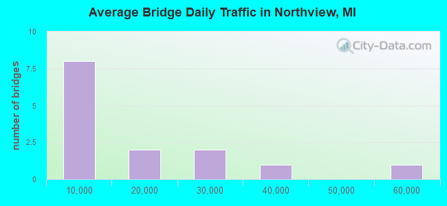
- 200,383Total average daily traffic
- 7,489Total average daily truck traffic
- National Bridge Inventory (NBI) Registered Bridges for Northview
- No street view available for this location
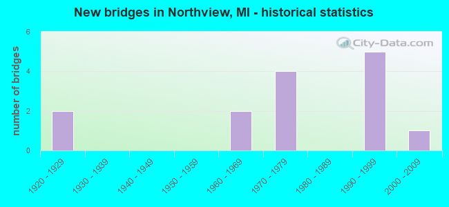
- New bridges - historical statistics
- 21920-1929
- 21960-1969
- 41970-1979
- 51990-1999
- 12000-2009
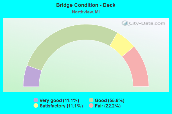
- Bridge Condition - Deck
- 11.1%Very good
- 55.6%Good
- 11.1%Satisfactory
- 22.2%Fair
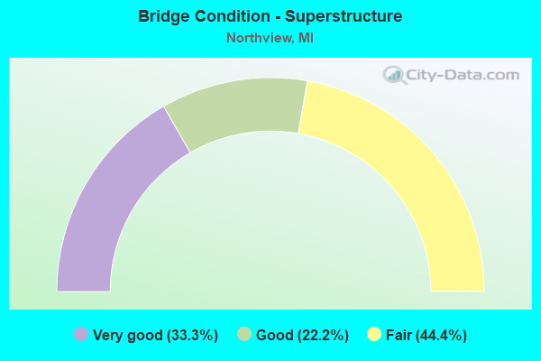
- Bridge Condition - Superstructure
- 33.3%Very good
- 22.2%Good
- 44.4%Fair
- Bridge Condition - Substructure
- 11.1%Very good
- 44.4%Good
- 33.3%Satisfactory
- 11.1%Fair
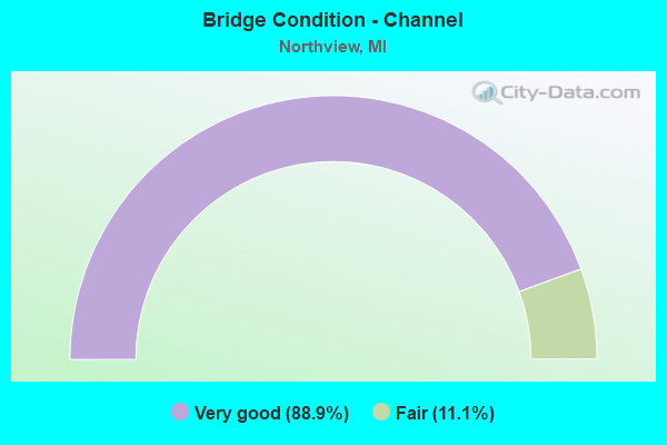
- Bridge Condition - Channel
- 88.9%Very good
- 11.1%Fair
Find on map >> Show street view
Structure Number: 4706, Location: 4.9 MI SW OF ROCKFORD (Lat: 43.064097, Lng: -85.579903), Route carried "on" structure: State highway 44, Year Built: 1929, Year Reconstructed: 2006, Status: Open, Structure Length: 12.50m (41.01ft), Average Daily Traffic: 33,588 (year 2007), Truck Traffic: 2%, Average Future Daily Traffic: 44,800 (year 2025), Design Load: HS 20, Features Intersected: GRAND RIVER
Minimum Vertical Clearance: 30.48m (100.00ft), Kilometerpoint: 4.242, Lanes on structure: 4, Base Highway Network: Yes (Inventory Route: 40, Subroute: 3), Owner: State Highway Agency, Approaching Roadway Width: 18.3m (60.0ft), Material/Design: Steel, Design/Construction: Stringer/Multi-beam, Number Of Spans In Main Unit: 6, Length of Maximum Span: 24.4m (80.1ft), Curb or Sidewalk Widths: Left: 2.2m (7.2ft), Right: 0.0m, Curb-To-Curb Width: 14.6m (47.9ft), Out-to-Out Width: 17.8m (58.4ft)
Condition: Deck: Good, Superstructure: Fair, Substructure: Fair, Channel: Fair, Operating Rating: 45.0 metric tons, Method Used To Determine Operating Rating: Load Factor (LF) rating reported by rating factor (RF) method using MS18 loading, Inventory Rating: 26.9 metric tons, Method Used To Determine Inventory Rating: Load Factor (LF) rating reported by rating factor (RF) method using MS18 loading, Structural Evaluation: Somewhat better than minimum adequacy, Deck Geometry: High priority of replacement, Waterway Adequacy: Equal to present minimum criteria, Approach Roadway Alignment: Equal to present desirable criteria, Designated Inspection Frequency: Every 24 months, Underwater Inspection Frequency: Every 60 months, Inspection Date: March 2021, Underwater Inspection Date: June 2020, Deck Structure Type: Concrete Cast-file-Place, Wearing Surface/Protective System: Wearing Surface: Latex Concrete
Find on map >> Show street view
Structure Number: 4992, Location: 5.4 MI N OF I-96 (Lat: 43.088950, Lng: -85.631717), Route carried "on" structure: County highway , Year Built: 1969, Year Reconstructed: 2009, Status: Open, Structure Length: 12.10m (39.70ft), Average Daily Traffic: 6,321 (year 1996), Truck Traffic: 6%, Average Future Daily Traffic: 11,416 (year 2016), Design Load: H 20, Features Intersected: US-131, Facility Carried by Structure: POST RD
Minimum Vertical Clearance: 30.48m (100.00ft), Kilometerpoint: 6.782, Lanes on structure: 2, Lanes under structure: 4, Owner: State Highway Agency, Approaching Roadway Width: 13.4m (44.0ft), Skew: 2 degrees, Material/Design: Steel, Design/Construction: Stringer/Multi-beam, Number Of Spans In Main Unit: 5, Length of Maximum Span: 32.3m (106.0ft), Curb-To-Curb Width: 13.0m (42.7ft), Out-to-Out Width: 14.1m (46.3ft)
Condition: Deck: Satisfactory, Superstructure: Fair, Substructure: Satisfactory, Operating Rating: 42.4 metric tons, Method Used To Determine Operating Rating: Load and Resistance Factor Rating (LRFR) rating reported by rating factor(RF) method using HL-93 loadings, Inventory Rating: 32.7 metric tons, Method Used To Determine Inventory Rating: Load and Resistance Factor Rating (LRFR) rating reported by rating factor(RF) method using HL-93 loadings, Structural Evaluation: Somewhat better than minimum adequacy, Deck Geometry: Somewhat better than minimum adequacy, Underclear: Meets minimum limits, Approach Roadway Alignment: Better than present minimum criteria, Designated Inspection Frequency: Every 24 months, Inspection Date: March 2021, Deck Structure Type: Concrete Cast-file-Place, Wearing Surface/Protective System: Wearing Surface: Latex Concrete
Find on map >> Show street view
Structure Number: 5027, Location: 0.35 MI E OF PETTIS AVE (Lat: 43.057564, Lng: -85.523444), Route carried "on" structure: County highway 4152, Year Built: 1973, Status: Open, Structure Length: 1.52m (4.99ft), Average Daily Traffic: 9,773 (year 2004), Average Future Daily Traffic: 16,610 (year 2024), Design Load: HS 20+Mod, Features Intersected: BEAR CREEK, Facility Carried by Structure: CANNONSBURG RD
Minimum Vertical Clearance: 30.48m (100.00ft), Kilometerpoint: 16.805, Lanes on structure: 2, Owner: County Highway Agency, Approaching Roadway Width: 13.4m (44.0ft), Material/Design: Prestressed concrete, Design/Construction: Box Beam or Girders - Multiple, Number Of Spans In Main Unit: 1, Length of Maximum Span: 15.2m (49.9ft), Curb-To-Curb Width: 13.4m (44.0ft), Out-to-Out Width: 14.2m (46.6ft)
Condition: Deck: Good, Superstructure: Good, Substructure: Good, Channel: Very good, Operating Rating: 67.0 metric tons, Method Used To Determine Operating Rating: Load Factor (LF), Inventory Rating: 40.2 metric tons, Method Used To Determine Inventory Rating: Load Factor (LF), Structural Evaluation: Better than present minimum criteria, Deck Geometry: Equal to present minimum criteria, Waterway Adequacy: Equal to present desirable criteria, Approach Roadway Alignment: Equal to present desirable criteria, Designated Inspection Frequency: Every 24 months, Inspection Date: December 2021, Deck Structure Type: Concrete Precast Panels, Wearing Surface/Protective System: Wearing Surface: Bituminous
Find on map >> Show street view
Structure Number: 5053, Location: 0.60 MI W OF M-44 (Lat: 43.064186, Lng: -85.591553), Route carried "on" structure: County highway 2001, Year Built: 1929, Year Reconstructed: 2011, Status: Open, Structure Length: 4.57m (14.99ft), Average Daily Traffic: 20,285 (year 2004), Average Future Daily Traffic: 34,480 (year 2024), Design Load: HS 20+Mod, Features Intersected: ROGUE RIVER, Facility Carried by Structure: WEST RIVER DRIVE
Minimum Vertical Clearance: 30.48m (100.00ft), Kilometerpoint: 10.899, Lanes on structure: 4, Owner: County Highway Agency, Approaching Roadway Width: 15.5m (50.9ft), Skew: 4 degrees, Material/Design: Steel, Design/Construction: Stringer/Multi-beam, Number Of Spans In Main Unit: 3, Length of Maximum Span: 15.2m (49.9ft), Curb-To-Curb Width: 15.9m (52.2ft), Out-to-Out Width: 17.0m (55.8ft)
Condition: Deck: Good, Superstructure: Good, Substructure: Satisfactory, Channel: Very good, Operating Rating: 46.0 metric tons, Method Used To Determine Operating Rating: Load and Resistance Factor Rating (LRFR) rating reported by rating factor(RF) method using HL-93 loadings, Inventory Rating: 32.4 metric tons, Method Used To Determine Inventory Rating: Load and Resistance Factor Rating (LRFR) rating reported by rating factor(RF) method using HL-93 loadings, Structural Evaluation: Equal to present minimum criteria, Deck Geometry: Meets minimum limits, Waterway Adequacy: Equal to present desirable criteria, Approach Roadway Alignment: Equal to present desirable criteria, Length Of Structure Improvement: 4.60m (15.09ft), Designated Inspection Frequency: Every 24 months, Inspection Date: October 2020, Bridge Improvement Cost: $200,000, Total Project Cost: $200,000, Deck Structure Type: Concrete Cast-file-Place, Wearing Surface/Protective System: Wearing Surface: Monolithic Concrete, Deck Protection: Epoxy Coated Reinforcing
Find on map >> Show street view
Structure Number: 513, Location: 0.47 MI S OF CANNONSBURG (Lat: 43.050067, Lng: -85.548889), Route carried "on" structure: County highway , Year Built: 1971, Status: Open, Structure Length: 0.94m (3.08ft), Average Daily Traffic: 358 (year 2004), Average Future Daily Traffic: 610 (year 2024), Design Load: HS 20+Mod, Features Intersected: BEAR CREEK, Facility Carried by Structure: CHAUNCEY DRIVE
Minimum Vertical Clearance: 30.48m (100.00ft), Kilometerpoint: 0.959, Lanes on structure: 2, Owner: County Highway Agency, Approaching Roadway Width: 5.5m (18.0ft), Material/Design: Prestressed concrete, Design/Construction: Box Beam or Girders - Multiple, Number Of Spans In Main Unit: 1, Length of Maximum Span: 8.2m (26.9ft), Curb-To-Curb Width: 6.1m (20.0ft), Out-to-Out Width: 6.2m (20.3ft)
Condition: Deck: Very good, Superstructure: Very good, Substructure: Good, Channel: Very good, Operating Rating: 85.7 metric tons, Method Used To Determine Operating Rating: Load Factor (LF), Inventory Rating: 51.3 metric tons, Method Used To Determine Inventory Rating: Load Factor (LF), Structural Evaluation: Better than present minimum criteria, Deck Geometry: Meets minimum limits, Waterway Adequacy: Equal to present desirable criteria, Approach Roadway Alignment: Equal to present minimum criteria, Designated Inspection Frequency: Every 24 months, Inspection Date: December 2021, Deck Structure Type: Concrete Precast Panels, Wearing Surface/Protective System: Wearing Surface: Bituminous
Find on map >> Show street view
Structure Number: 515, Location: 0.30 MI W OF PACKER DRIVE (Lat: 43.072381, Lng: -85.597064), Route carried "on" structure: County highway , Year Built: 1970, Status: Open, Structure Length: 4.57m (14.99ft), Average Daily Traffic: 5,646 (year 2004), Average Future Daily Traffic: 9,600 (year 2024), Design Load: HS 20+Mod, Features Intersected: ROGUE RIVER, Facility Carried by Structure: ROGUE RIVER RD
Minimum Vertical Clearance: 30.48m (100.00ft), Kilometerpoint: 2.768, Lanes on structure: 2, Owner: County Highway Agency, Approaching Roadway Width: 6.7m (22.0ft), Skew: 2 degrees, Material/Design: Prestressed concrete, Design/Construction: Box Beam or Girders - Multiple, Number Of Spans In Main Unit: 3, Length of Maximum Span: 15.2m (49.9ft), Curb-To-Curb Width: 9.4m (30.8ft), Out-to-Out Width: 10.2m (33.5ft)
Condition: Deck: Fair, Superstructure: Fair, Substructure: Satisfactory, Channel: Very good, Operating Rating: 51.9 metric tons, Method Used To Determine Operating Rating: Load Factor (LF), Inventory Rating: 31.1 metric tons, Method Used To Determine Inventory Rating: Load Factor (LF), Structural Evaluation: Somewhat better than minimum adequacy, Deck Geometry: High priority of corrective action, Waterway Adequacy: Equal to present desirable criteria, Approach Roadway Alignment: Equal to present minimum criteria, Designated Inspection Frequency: Every 24 months, Inspection Date: November 2021, Deck Structure Type: Concrete Precast Panels, Wearing Surface/Protective System: Wearing Surface: Bituminous
Find on map >> Show street view
Structure Number: 5151, Location: 0.20 MI W OF PACKER DRIVE (Lat: 43.073533, Lng: -85.594636), Route carried "on" structure: County highway , Year Built: 1997, Status: Open, Structure Length: 0.61m (2.00ft), Average Daily Traffic: 5,646 (year 2004), Truck Traffic: 3%, Average Future Daily Traffic: 9,600 (year 2024), Design Load: HS 20+Mod, Features Intersected: UNNAMED CREEK, Facility Carried by Structure: ROGUE RIVER RD
Minimum Vertical Clearance: 30.48m (100.00ft), Kilometerpoint: 3.005, Lanes on structure: 2, Owner: County Highway Agency, Approaching Roadway Width: 9.1m (29.9ft), Material/Design: Steel, Design/Construction: Culvert, Number Of Spans In Main Unit: 3, Length of Maximum Span: 1.5m (4.9ft)
Condition: Channel: Very good, Culverts: Good, Operating Rating: 46.7 metric tons, Method Used To Determine Operating Rating: Load Factor (LF) rating reported by rating factor (RF) method using MS18 loading, Inventory Rating: 43.4 metric tons, Method Used To Determine Inventory Rating: Load Factor (LF) rating reported by rating factor (RF) method using MS18 loading, Structural Evaluation: Better than present minimum criteria, Waterway Adequacy: Equal to present desirable criteria, Approach Roadway Alignment: Equal to present desirable criteria, Designated Inspection Frequency: Every 24 months, Inspection Date: November 2021
Find on map >> Show street view
Structure Number: 5152, Location: 0.70 MI N OF ROGUE RIVER (Lat: 43.082256, Lng: -85.590556), Route carried "on" structure: County highway , Year Built: 1973, Status: Open, Structure Length: 3.99m (13.09ft), Average Daily Traffic: 1,761 (year 2005), Average Future Daily Traffic: 3,000 (year 2025), Design Load: HS 20+Mod, Features Intersected: ROGUE RIVER, Facility Carried by Structure: PACKER DRIVE
Minimum Vertical Clearance: 30.48m (100.00ft), Kilometerpoint: 2.504, Lanes on structure: 2, Owner: County Highway Agency, Approaching Roadway Width: 8.5m (27.9ft), Material/Design: Prestressed concrete, Design/Construction: Box Beam or Girders - Multiple, Number Of Spans In Main Unit: 3, Length of Maximum Span: 13.4m (44.0ft), Curb-To-Curb Width: 9.8m (32.2ft), Out-to-Out Width: 10.1m (33.1ft)
Condition: Deck: Fair, Superstructure: Fair, Substructure: Good, Channel: Very good, Operating Rating: 47.1 metric tons, Method Used To Determine Operating Rating: Load Factor (LF), Inventory Rating: 28.2 metric tons, Method Used To Determine Inventory Rating: Load Factor (LF), Structural Evaluation: Somewhat better than minimum adequacy, Deck Geometry: Somewhat better than minimum adequacy, Waterway Adequacy: Equal to present desirable criteria, Approach Roadway Alignment: Equal to present minimum criteria, Designated Inspection Frequency: Every 24 months, Inspection Date: November 2021, Deck Structure Type: Concrete Precast Panels, Wearing Surface/Protective System: Wearing Surface: Bituminous
Find on map >> Show street view
Structure Number: 13154, Location: 0.3 MI E OF HUNSBERGER AV (Lat: 43.046347, Lng: -85.613033), Route carried "on" structure: County highway , Year Built: 1999, Status: Open, Structure Length: 2.47m (8.10ft), Average Daily Traffic: 3,370 (year 2001), Average Future Daily Traffic: 5,730 (year 2021), Design Load: HS 20+Mod, Features Intersected: JUPITER AVE, Facility Carried by Structure: AIRWAY STREET
Minimum Vertical Clearance: 30.48m (100.00ft), Kilometerpoint: 0.517, Lanes on structure: 2, Lanes under structure: 4, Owner: County Highway Agency, Approaching Roadway Width: 12.2m (40.0ft), Material/Design: Prestressed concrete, Design/Construction: Box Beam or Girders - Multiple, Number Of Spans In Main Unit: 1, Length of Maximum Span: 24.7m (81.0ft), Curb-To-Curb Width: 12.2m (40.0ft), Out-to-Out Width: 13.2m (43.3ft)
Condition: Deck: Good, Superstructure: Very good, Substructure: Very good, Operating Rating: 85.7 metric tons, Method Used To Determine Operating Rating: Load Factor (LF), Inventory Rating: 36.2 metric tons, Method Used To Determine Inventory Rating: Load Factor (LF), Structural Evaluation: Equal to present desirable criteria, Deck Geometry: Equal to present minimum criteria, Underclear: Equal to present minimum criteria, Approach Roadway Alignment: Better than present minimum criteria, Designated Inspection Frequency: Every 24 months, Inspection Date: November 2021, Deck Structure Type: Aluminum, Wearing Surface/Protective System: Wearing Surface: Monolithic Concrete, Deck Protection: Epoxy Coated Reinforcing
Find on map >> Show street view
Structure Number: 13155, Location: 1000 FT N OF COIT AVE (Lat: 43.062339, Lng: -85.609292), Route carried "on" structure: County highway , Year Built: 1998, Status: Open, Structure Length: 38.13m (125.10ft), Average Daily Traffic: 12,185 (year 2017), Truck Traffic: 8%, Average Future Daily Traffic: 15,841 (year 2037), Design Load: HS 20+Mod, Features Intersected: GRAND RIVER, Facility Carried by Structure: JUPITER AVE
Minimum Vertical Clearance: 30.48m (100.00ft), Kilometerpoint: 2.850, Lanes on structure: 4, Owner: County Highway Agency, Approaching Roadway Width: 15.5m (50.9ft), Skew: 2 degrees, Material/Design: Prestressed concrete, Design/Construction: Stringer/Multi-beam, Number Of Spans In Main Unit: 10, Length of Maximum Span: 38.1m (125.0ft), Curb or Sidewalk Widths: Left: 1.8m (5.9ft), Right: 1.8m (5.9ft), Curb-To-Curb Width: 17.7m (58.1ft), Out-to-Out Width: 20.3m (66.6ft)
Condition: Deck: Good, Superstructure: Very good, Substructure: Good, Channel: Very good, Inventory Rating: 56.4 metric tons, Method Used To Determine Inventory Rating: Load Factor (LF), Structural Evaluation: Better than present minimum criteria, Deck Geometry: Somewhat better than minimum adequacy, Waterway Adequacy: Better than present minimum criteria, Approach Roadway Alignment: Better than present minimum criteria, Designated Inspection Frequency: Every 24 months, Inspection Date: November 2021, Deck Structure Type: Concrete Cast-file-Place, Wearing Surface/Protective System: Wearing Surface: Monolithic Concrete, Deck Protection: Epoxy Coated Reinforcing
Find on map >> Show street view
Structure Number: 13156, Location: 700 FT N OF COIT AVE (Lat: 43.059997, Lng: -85.609342), Route carried "on" structure: County highway , Year Built: 1998, Status: Open, Structure Length: 0.67m (2.20ft), Average Daily Traffic: 11,400 (year 2000), Average Future Daily Traffic: 19,400 (year 2020), Design Load: HS 20+Mod, Features Intersected: FLOODWAY, Facility Carried by Structure: JUPITER AVE
Minimum Vertical Clearance: 30.48m (100.00ft), Kilometerpoint: 2.590, Lanes on structure: 4, Owner: County Highway Agency, Approaching Roadway Width: 15.5m (50.9ft), Material/Design: Concrete, Design/Construction: Culvert, Number Of Spans In Main Unit: 2, Length of Maximum Span: 3.0m (9.8ft), Out-to-Out Width: 12.5m (41.0ft)
Condition: Channel: Very good, Culverts: Good, Operating Rating: 49.2 metric tons, Method Used To Determine Operating Rating: Load Factor (LF) rating reported by rating factor (RF) method using MS18 loading, Inventory Rating: 38.2 metric tons, Method Used To Determine Inventory Rating: Load Factor (LF) rating reported by rating factor (RF) method using MS18 loading, Structural Evaluation: Better than present minimum criteria, Waterway Adequacy: Equal to present desirable criteria, Approach Roadway Alignment: Equal to present desirable criteria, Designated Inspection Frequency: Every 24 months, Inspection Date: November 2021
Find on map >> Show street view
Structure Number: 4992, Location: 5.4 MI N OF I-96 (Lat: 43.088950, Lng: -85.631717), Route carried "under" structure: US 131, Year Built: 1969, Structure Length: 0. m, Average Daily Traffic: 58,850 (year 2007), Truck Traffic: 9%, Features Intersected: US-131, Facility Carried by Structure: POST RD
Minimum Vertical Clearance: 4.65m (15.26ft), Kilometerpoint: 37.657, Lanes on structure: 2, Lanes under structure: 4, Material/Design: Steel, Design/Construction: Stringer/Multi-beam, Length of Maximum Span: 32.3m (106.0ft)
Find on map >> Show street view
Structure Number: 13152, Location: 0.1 MI E OF SAMRICK AVE (Lat: 43.066583, Lng: -85.626267), Route carried "under" structure: County highway , Year Built: 2001, Structure Length: 0. m, Average Daily Traffic: 22,700 (year 2002), Features Intersected: WEST RIVER ROAD, Facility Carried by Structure: WHITE PINE TRAIL
Minimum Vertical Clearance: 4.67m (15.32ft), Kilometerpoint: 8.086, Lanes under structure: 4, Material/Design: Steel, Design/Construction: Truss - Thru, Length of Maximum Span: 52.7m (172.9ft)
Find on map >> Show street view
Structure Number: 13154, Location: 0.3 MI E OF HUNSBERGER AV (Lat: 43.046347, Lng: -85.613033), Route carried "under" structure: County highway , Year Built: 1999, Structure Length: 0. m, Average Daily Traffic: 8,500 (year 2002), Features Intersected: JUPITER AVE, Facility Carried by Structure: AIRWAY STREET
Minimum Vertical Clearance: 4.88m (16.01ft), Kilometerpoint: 1.032, Lanes on structure: 2, Lanes under structure: 4, Material/Design: Prestressed concrete, Design/Construction: Box Beam or Girders - Multiple, Length of Maximum Span: 24.7m (81.0ft)