Bridge Statistics for Northwest Harborcreek, Pennsylvania (PA)
Condition, Traffic, Stress, Structural Evaluation, Project Costs
- National Bridge Inventory (NBI) Statistics
- 16Number of bridges
- 108ft / 32.8mTotal length
- $753,000Total costs
- 108,711Total average daily traffic
- 10,265Total average daily truck traffic
- National Bridge Inventory (NBI) Registered Bridges for Northwest Harborcreek
- No street view available for this location
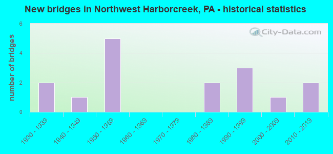
- New bridges - historical statistics
- 21930-1939
- 11940-1949
- 51950-1959
- 21980-1989
- 31990-1999
- 12000-2009
- 22010-2019
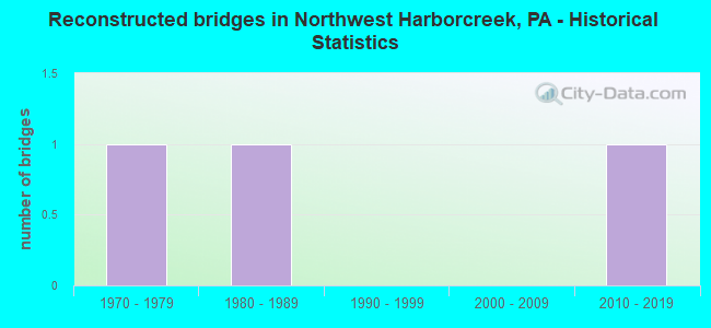
- Reconstructed bridges - Historical Statistics
- 11970-1979
- 11980-1989
- 01990-1999
- 02000-2009
- 12010-2019
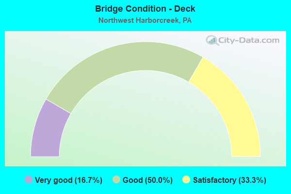
- Bridge Condition - Deck
- 16.7%Very good
- 50.0%Good
- 33.3%Satisfactory
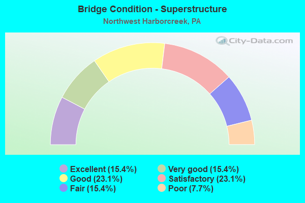
- Bridge Condition - Superstructure
- 15.4%Excellent
- 15.4%Very good
- 23.1%Good
- 23.1%Satisfactory
- 15.4%Fair
- 7.7%Poor
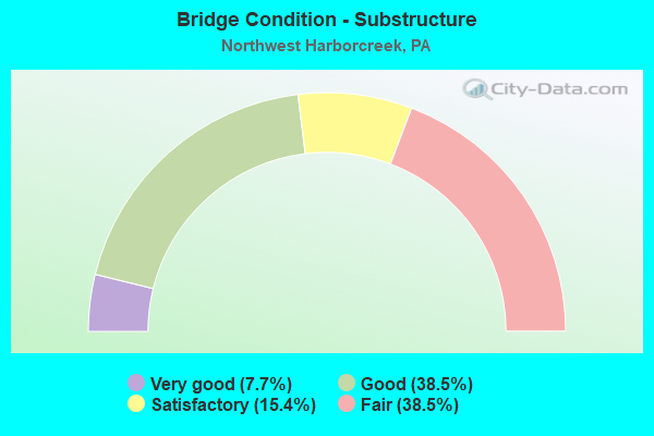
- Bridge Condition - Substructure
- 7.7%Very good
- 38.5%Good
- 15.4%Satisfactory
- 38.5%Fair
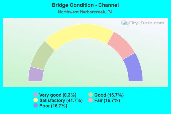
- Bridge Condition - Channel
- 8.3%Very good
- 16.7%Good
- 41.7%Satisfactory
- 16.7%Fair
- 16.7%Poor
Find on map >> Show street view
Structure Number: 15813, Location: HARBOR CREEK TOWNSHIP (Lat: 42.175019, Lng: -79.985789), Route carried "on" structure: State highway 5, Year Built: 1933, Status: Open, Structure Length: 1.52m (4.99ft), Average Daily Traffic: 7,841 (year 2022), Truck Traffic: 3%, Average Future Daily Traffic: 10,499 (year 2032), Design Load: H 20, Features Intersected: OVER SIX MILE CREEK
Minimum Vertical Clearance: 30+ m (98+ ft), Kilometerpoint: 50.456, Lanes on structure: 2, Owner: State Highway Agency, Approaching Roadway Width: 8.5m (27.9ft), Material/Design: Steel, Design/Construction: Stringer/Multi-beam, Number Of Spans In Main Unit: 1, Length of Maximum Span: 14.3m (46.9ft), Curb-To-Curb Width: 9.8m (32.2ft), Out-to-Out Width: 10.7m (35.1ft)
Condition: Deck: Satisfactory, Superstructure: Poor, Substructure: Fair, Channel: Good, Operating Rating: 53.5 metric tons, Method Used To Determine Operating Rating: Load Factor (LF), Inventory Rating: 31.8 metric tons, Method Used To Determine Inventory Rating: Load Factor (LF), Structural Evaluation: Meets minimum limits, Deck Geometry: Meets minimum limits, Waterway Adequacy: Equal to present minimum criteria, Approach Roadway Alignment: Equal to present desirable criteria, Length Of Structure Improvement: 1.50m (4.92ft), Designated Inspection Frequency: Every 24 months, Inspection Date: March 2020, Bridge Improvement Cost: $6,000, Roadway Improvement Cost: $25,000, Total Project Cost: $76,000, Deck Structure Type: Closed Grating, Wearing Surface/Protective System: Wearing Surface: Bituminous
Find on map >> Show street view
Structure Number: 15815, Location: HARBOR CREEK TOWNSHIP (Lat: 42.191956, Lng: -79.951008), Route carried "on" structure: State highway 5, Year Built: 1930, Status: Open, Structure Length: 0.61m (2.00ft), Average Daily Traffic: 7,841 (year 2022), Truck Traffic: 3%, Average Future Daily Traffic: 10,499 (year 2032), Design Load: H 20, Features Intersected: OVER EIGHT MILE CREEK
Minimum Vertical Clearance: 30+ m (98+ ft), Kilometerpoint: 54.177, Lanes on structure: 2, Owner: State Highway Agency, Approaching Roadway Width: 10.1m (33.1ft), Skew: 3 degrees, Material/Design: Concrete, Design/Construction: Arch - Deck, Number Of Spans In Main Unit: 1, Length of Maximum Span: 6.1m (20.0ft), Curb-To-Curb Width: 11.9m (39.0ft), Out-to-Out Width: 18.9m (62.0ft)
Condition: Superstructure: Fair, Substructure: Fair, Channel: Fair, Operating Rating: 75.3 metric tons, Method Used To Determine Operating Rating: Allowable Stress (AS), Inventory Rating: 45.4 metric tons, Method Used To Determine Inventory Rating: Allowable Stress (AS), Structural Evaluation: Somewhat better than minimum adequacy, Deck Geometry: Somewhat better than minimum adequacy, Waterway Adequacy: Superior to present desirable criteria, Approach Roadway Alignment: Equal to present desirable criteria, Length Of Structure Improvement: 1.20m (3.94ft), Designated Inspection Frequency: Every 24 months, Inspection Date: March 2021
Find on map >> Show street view
Structure Number: 15917, Location: HARBOR CREEK TOWNSHIP (Lat: 42.157650, Lng: -79.977778), Route carried "on" structure: US 20, Year Built: 1954, Status: Open, Structure Length: 1.86m (6.10ft), Average Daily Traffic: 13,501 (year 2022), Truck Traffic: 3%, Average Future Daily Traffic: 10,595 (year 2032), Design Load: HS 20, Features Intersected: OVER SIX MILE CREEK
Minimum Vertical Clearance: 30+ m (98+ ft), Kilometerpoint: 52.096, Lanes on structure: 4, Owner: State Highway Agency, Approaching Roadway Width: 17.7m (58.1ft), Skew: 1 degrees, Material/Design: Steel, Design/Construction: Stringer/Multi-beam, Number Of Spans In Main Unit: 1, Length of Maximum Span: 17.7m (58.1ft), Curb-To-Curb Width: 19.1m (62.7ft), Out-to-Out Width: 19.8m (65.0ft)
Condition: Deck: Satisfactory, Superstructure: Satisfactory, Substructure: Fair, Channel: Poor, Operating Rating: 57.2 metric tons, Method Used To Determine Operating Rating: Load Factor (LF), Inventory Rating: 34.5 metric tons, Method Used To Determine Inventory Rating: Load Factor (LF), Structural Evaluation: Somewhat better than minimum adequacy, Deck Geometry: Equal to present minimum criteria, Waterway Adequacy: Equal to present desirable criteria, Approach Roadway Alignment: Equal to present desirable criteria, Length Of Structure Improvement: 2.50m (8.20ft), Designated Inspection Frequency: Every 24 months, Inspection Date: October 2021, Bridge Improvement Cost: $8,000, Roadway Improvement Cost: $23,000, Total Project Cost: $107,000, Deck Structure Type: Concrete Cast-file-Place, Wearing Surface/Protective System: Wearing Surface: Bituminous, Membrane: Preformed Fabric
Find on map >> Show street view
Structure Number: 16083, Location: HARBOR CREEK TOWNSHIP (Lat: 42.139375, Lng: -79.923422), Route carried "on" structure: Interstate 90, Year Built: 1959, Year Reconstructed: 1980, Status: Open, Structure Length: 4.48m (14.70ft), Average Daily Traffic: 18,471 (year 2021), Truck Traffic: 18%, Average Future Daily Traffic: 13,875 (year 2032), Design Load: HS 20+Mod, Features Intersected: OVER SR 531,DOPOT RD
Minimum Vertical Clearance: 30+ m (98+ ft), Kilometerpoint: 55.558, Lanes on structure: 2, Lanes under structure: 2, Base Highway Network: Yes, Owner: State Highway Agency, Approaching Roadway Width: 11.6m (38.1ft), Skew: 13 degrees, Material/Design: Prestressed concrete, Design/Construction: Box Beam or Girders - Multiple, Number Of Spans In Main Unit: 3, Length of Maximum Span: 16.5m (54.1ft), Curb or Sidewalk Widths: Left: 0.2m (0.7ft), Right: 0.2m (0.7ft), Curb-To-Curb Width: 12.2m (40.0ft), Out-to-Out Width: 13.3m (43.6ft)
Condition: Deck: Good, Superstructure: Satisfactory, Substructure: Satisfactory, Operating Rating: 95.3 metric tons, Method Used To Determine Operating Rating: Load Factor (LF), Inventory Rating: 57.2 metric tons, Method Used To Determine Inventory Rating: Load Factor (LF), Structural Evaluation: Equal to present minimum criteria, Deck Geometry: Better than present minimum criteria, Underclear: Equal to present minimum criteria, Approach Roadway Alignment: Equal to present desirable criteria, Length Of Structure Improvement: 4.50m (14.76ft), Designated Inspection Frequency: Every 48 months, Inspection Date: August 2020, Bridge Improvement Cost: $7,000, Roadway Improvement Cost: $27,000, Total Project Cost: $98,000, Deck Structure Type: Concrete Cast-file-Place, Wearing Surface/Protective System: Wearing Surface: Monolithic Concrete
Find on map >> Show street view
Structure Number: 16085, Location: HARBOR CREEK TOWNSHIP (Lat: 42.139628, Lng: -79.923422), Route carried "on" structure: Interstate 90, Year Built: 1959, Year Reconstructed: 1977, Status: Open, Structure Length: 5.36m (17.59ft), Average Daily Traffic: 18,402 (year 2021), Truck Traffic: 23%, Average Future Daily Traffic: 14,232 (year 2032), Design Load: HS 20+Mod, Features Intersected: OVER SR 531,DEPOT RD
Minimum Vertical Clearance: 30+ m (98+ ft), Kilometerpoint: 55.474, Lanes on structure: 2, Lanes under structure: 2, Base Highway Network: Yes, Owner: State Highway Agency, Approaching Roadway Width: 11.6m (38.1ft), Skew: 13 degrees, Material/Design: Prestressed concrete, Design/Construction: Box Beam or Girders - Multiple, Number Of Spans In Main Unit: 3, Length of Maximum Span: 21.0m (68.9ft), Curb or Sidewalk Widths: Left: 0.2m (0.7ft), Right: 0.2m (0.7ft), Curb-To-Curb Width: 12.2m (40.0ft), Out-to-Out Width: 13.3m (43.6ft)
Condition: Deck: Good, Superstructure: Good, Substructure: Good, Inventory Rating: 72.6 metric tons, Method Used To Determine Inventory Rating: Load Factor (LF), Structural Evaluation: Better than present minimum criteria, Deck Geometry: Better than present minimum criteria, Underclear: Superior to present desirable criteria, Approach Roadway Alignment: Equal to present desirable criteria, Length Of Structure Improvement: 5.40m (17.72ft), Designated Inspection Frequency: Every 24 months, Inspection Date: August 2020, Bridge Improvement Cost: $30,000, Roadway Improvement Cost: $89,000, Total Project Cost: $408,000, Deck Structure Type: Concrete Cast-file-Place, Wearing Surface/Protective System: Wearing Surface: Monolithic Concrete
Find on map >> Show street view
Structure Number: 16166, Location: HARBOR CREEK TOWNSHIP (Lat: 42.134686, Lng: -80.005756), Route carried "on" structure: Alternate State highway 430, Year Built: 1941, Status: Open, Structure Length: 1.52m (4.99ft), Average Daily Traffic: 5,483 (year 2022), Truck Traffic: 4%, Average Future Daily Traffic: 6,933 (year 2032), Design Load: H 20, Features Intersected: OVER FOUR MILE CREEK
Minimum Vertical Clearance: 30+ m (98+ ft), Kilometerpoint: 1.053, Lanes on structure: 2, Base Highway Network: Yes, Owner: State Highway Agency, Approaching Roadway Width: 6.7m (22.0ft), Skew: 1 degrees, Material/Design: Concrete, Design/Construction: Tee Beam, Number Of Spans In Main Unit: 1, Length of Maximum Span: 14.6m (47.9ft), Curb or Sidewalk Widths: Left: 0.0m, Right: 1.2m (3.9ft), Curb-To-Curb Width: 11.2m (36.7ft), Out-to-Out Width: 12.1m (39.7ft)
Condition: Deck: Satisfactory, Superstructure: Fair, Substructure: Fair, Channel: Fair, Operating Rating: 40.8 metric tons, Method Used To Determine Operating Rating: Load Factor (LF), Inventory Rating: 24.5 metric tons, Method Used To Determine Inventory Rating: Load Factor (LF), Structural Evaluation: Somewhat better than minimum adequacy, Deck Geometry: Meets minimum limits, Waterway Adequacy: Equal to present minimum criteria, Approach Roadway Alignment: Equal to present desirable criteria, Length Of Structure Improvement: 2.20m (7.22ft), Designated Inspection Frequency: Every 24 months, Inspection Date: July 2021, Wearing Surface/Protective System: Wearing Surface: Monolithic Concrete
Find on map >> Show street view
Structure Number: 16442, Location: 600 FT EAST OF SR 4030 (Lat: 42.125822, Lng: -79.998306), Route carried "on" structure: City street , Year Built: 1981, Year Reconstructed: 2019, Status: Open, Structure Length: 2.10m (6.89ft), Average Daily Traffic: 3,125 (year 2015), Truck Traffic: 1%, Average Future Daily Traffic: 3,391 (year 2035), Design Load: HS 20, Features Intersected: FOUR MILE CREEK, Facility Carried by Structure: T-717 COOPER ROAD
Minimum Vertical Clearance: 30+ m (98+ ft), Kilometerpoint: 0.000, Lanes on structure: 2, Owner: Town or Township Highway Agency, Approaching Roadway Width: 9.8m (32.2ft), Skew: 2 degrees, Material/Design: Prestressed concrete, Design/Construction: Box Beam or Girders - Multiple, Number Of Spans In Main Unit: 1, Length of Maximum Span: 20.4m (66.9ft), Curb-To-Curb Width: 9.8m (32.2ft), Out-to-Out Width: 10.4m (34.1ft)
Condition: Deck: Good, Superstructure: Satisfactory, Substructure: Satisfactory, Channel: Poor, Operating Rating: 69.9 metric tons, Method Used To Determine Operating Rating: Load Factor (LF), Inventory Rating: 31.8 metric tons, Method Used To Determine Inventory Rating: Load Factor (LF), Structural Evaluation: Equal to present minimum criteria, Deck Geometry: Meets minimum limits, Waterway Adequacy: Better than present minimum criteria, Approach Roadway Alignment: Equal to present desirable criteria, Length Of Structure Improvement: 2.70m (8.86ft), Designated Inspection Frequency: Every 24 months, Inspection Date: July 2021, Wearing Surface/Protective System: Wearing Surface: Monolithic Concrete, Deck Protection: Epoxy Coated Reinforcing
Find on map >> Show street view
Structure Number: 16443, Location: 1500 FT SE OF SR 0020 (Lat: 42.153950, Lng: -79.978361), Route carried "on" structure: City street 7210, Year Built: 1989, Status: Open, Structure Length: 2.80m (9.19ft), Average Daily Traffic: 1,011 (year 2013), Truck Traffic: 1%, Average Future Daily Traffic: 1,097 (year 2033), Design Load: HS 25 or greater, Features Intersected: SIX MILE CREEK, Facility Carried by Structure: T-729 CLARK ROAD
Minimum Vertical Clearance: 30+ m (98+ ft), Kilometerpoint: 0.000, Lanes on structure: 2, Owner: Town or Township Highway Agency, Approaching Roadway Width: 7.9m (25.9ft), Skew: 1 degrees, Material/Design: Prestressed concrete, Design/Construction: Box Beam or Girders - Single/Spread, Number Of Spans In Main Unit: 1, Length of Maximum Span: 27.4m (89.9ft), Curb-To-Curb Width: 8.5m (27.9ft), Out-to-Out Width: 9.6m (31.5ft)
Condition: Deck: Good, Superstructure: Good, Substructure: Good, Channel: Satisfactory, Operating Rating: 65.3 metric tons, Method Used To Determine Operating Rating: Load Factor (LF), Inventory Rating: 39.0 metric tons, Method Used To Determine Inventory Rating: Load Factor (LF), Structural Evaluation: Better than present minimum criteria, Deck Geometry: Somewhat better than minimum adequacy, Waterway Adequacy: Better than present minimum criteria, Approach Roadway Alignment: Better than present minimum criteria, Length Of Structure Improvement: 2.70m (8.86ft), Designated Inspection Frequency: Every 24 months, Inspection Date: August 2021, Deck Structure Type: Concrete Cast-file-Place, Wearing Surface/Protective System: Wearing Surface: Monolithic Concrete, Membrane: Other, Deck Protection: Epoxy Coated Reinforcing
Find on map >> Show street view
Structure Number: 16444, Location: 600 FT SW OF HIGHMEYER RD (Lat: 42.187342, Lng: -79.931992), Route carried "on" structure: City street 7210, Year Built: 1993, Status: Open, Structure Length: 0.91m (2.99ft), Average Daily Traffic: 115 (year 2013), Truck Traffic: 6%, Average Future Daily Traffic: 125 (year 2033), Design Load: HS 25 or greater, Features Intersected: EIGHT MILE CREEK, Facility Carried by Structure: T-753 DUTTON ROAD
Minimum Vertical Clearance: 30+ m (98+ ft), Kilometerpoint: 0.000, Lanes on structure: 2, Owner: Town or Township Highway Agency, Approaching Roadway Width: 7.3m (24.0ft), Skew: 4 degrees, Material/Design: Concrete, Design/Construction: Culvert, Number Of Spans In Main Unit: 2, Length of Maximum Span: 4.3m (14.1ft)
Condition: Channel: Satisfactory, Culverts: Good, Operating Rating: 89.8 metric tons, Method Used To Determine Operating Rating: Load Factor (LF), Inventory Rating: 56.2 metric tons, Method Used To Determine Inventory Rating: Load Factor (LF), Structural Evaluation: Better than present minimum criteria, Waterway Adequacy: Better than present minimum criteria, Approach Roadway Alignment: Equal to present desirable criteria, Length Of Structure Improvement: 0.90m (2.95ft), Designated Inspection Frequency: Every 24 months, Inspection Date: August 2021
Find on map >> Show street view
Structure Number: 39545, Location: HARBOR CREEK TOWNSHIP (Lat: 42.165992, Lng: -79.954178), Route carried "on" structure: US 20, Year Built: 1997, Status: Open, Structure Length: 1.98m (6.50ft), Average Daily Traffic: 7,595 (year 2021), Truck Traffic: 5%, Average Future Daily Traffic: 13,086 (year 2032), Design Load: HS 25 or greater, Features Intersected: OVER SEVEN MILE CREEK
Minimum Vertical Clearance: 30+ m (98+ ft), Kilometerpoint: 54.555, Lanes on structure: 2, Owner: State Highway Agency, Approaching Roadway Width: 13.7m (44.9ft), Skew: 6 degrees, Material/Design: Prestressed concrete, Design/Construction: Stringer/Multi-beam, Number Of Spans In Main Unit: 1, Length of Maximum Span: 18.0m (59.1ft), Curb or Sidewalk Widths: Left: 0.2m (0.7ft), Right: 0.2m (0.7ft), Curb-To-Curb Width: 13.7m (44.9ft), Out-to-Out Width: 14.8m (48.6ft)
Condition: Deck: Satisfactory, Superstructure: Very good, Substructure: Good, Channel: Good, Operating Rating: 89.8 metric tons, Method Used To Determine Operating Rating: Load Factor (LF), Inventory Rating: 40.8 metric tons, Method Used To Determine Inventory Rating: Load Factor (LF), Structural Evaluation: Better than present minimum criteria, Deck Geometry: Superior to present desirable criteria, Waterway Adequacy: Equal to present minimum criteria, Approach Roadway Alignment: Equal to present minimum criteria, Length Of Structure Improvement: 2.70m (8.86ft), Designated Inspection Frequency: Every 48 months, Inspection Date: August 2019, Bridge Improvement Cost: $5,000, Roadway Improvement Cost: $16,000, Total Project Cost: $64,000, Deck Structure Type: Concrete Cast-file-Place, Wearing Surface/Protective System: Wearing Surface: Bituminous, Membrane: Preformed Fabric, Deck Protection: Epoxy Coated Reinforcing
Find on map >> Show street view
Structure Number: 40358, Location: 2000 FT SE OF SR 5 (Lat: 42.168314, Lng: -79.987286), Route carried "on" structure: City street , Year Built: 1997, Status: Open, Structure Length: 2.99m (9.81ft), Average Daily Traffic: 671 (year 2013), Truck Traffic: 3%, Average Future Daily Traffic: 728 (year 2033), Design Load: HS 25 or greater, Features Intersected: SIX MILE CREEK, Facility Carried by Structure: T-610 BOYER ROAD
Minimum Vertical Clearance: 30+ m (98+ ft), Kilometerpoint: 0.000, Lanes on structure: 2, Owner: Town or Township Highway Agency, Approaching Roadway Width: 8.5m (27.9ft), Skew: 4 degrees, Material/Design: Prestressed concrete, Design/Construction: Box Beam or Girders - Multiple, Number Of Spans In Main Unit: 1, Length of Maximum Span: 29.0m (95.1ft), Curb or Sidewalk Widths: Left: 0.2m (0.7ft), Right: 0.2m (0.7ft), Curb-To-Curb Width: 8.9m (29.2ft), Out-to-Out Width: 9.9m (32.5ft)
Condition: Deck: Good, Superstructure: Good, Substructure: Fair, Channel: Satisfactory, Operating Rating: 64.4 metric tons, Method Used To Determine Operating Rating: Load Factor (LF), Inventory Rating: 38.1 metric tons, Method Used To Determine Inventory Rating: Load Factor (LF), Structural Evaluation: Somewhat better than minimum adequacy, Deck Geometry: Somewhat better than minimum adequacy, Waterway Adequacy: Better than present minimum criteria, Approach Roadway Alignment: Somewhat better than minimum adequacy, Length Of Structure Improvement: 3.70m (12.14ft), Designated Inspection Frequency: Every 24 months, Inspection Date: August 2021, Deck Structure Type: Concrete Cast-file-Place, Wearing Surface/Protective System: Wearing Surface: Monolithic Concrete, Deck Protection: Epoxy Coated Reinforcing
Find on map >> Show street view
Structure Number: 41233, Location: HARBOR CREEK TOWNSHIP (Lat: 42.180714, Lng: -79.972944), Route carried "on" structure: State highway 5, Year Built: 2001, Status: Open, Structure Length: 1.37m (4.49ft), Average Daily Traffic: 7,841 (year 2022), Truck Traffic: 3%, Average Future Daily Traffic: 10,499 (year 2032), Design Load: HS 25 or greater, Features Intersected: OVER ELLIOTTS CREEK
Minimum Vertical Clearance: 30+ m (98+ ft), Kilometerpoint: 51.945, Lanes on structure: 2, Owner: State Highway Agency, Approaching Roadway Width: 13.1m (43.0ft), Skew: 3 degrees, Material/Design: Prestressed concrete, Design/Construction: Box Beam or Girders - Single/Spread, Number Of Spans In Main Unit: 1, Length of Maximum Span: 13.1m (43.0ft), Curb or Sidewalk Widths: Left: 0.2m (0.7ft), Right: 0.2m (0.7ft), Curb-To-Curb Width: 13.2m (43.3ft), Out-to-Out Width: 14.1m (46.3ft)
Condition: Deck: Very good, Superstructure: Excellent, Substructure: Good, Channel: Satisfactory, Operating Rating: 98.9 metric tons, Method Used To Determine Operating Rating: Load Factor (LF), Inventory Rating: 44.5 metric tons, Method Used To Determine Inventory Rating: Load Factor (LF), Structural Evaluation: Better than present minimum criteria, Deck Geometry: Somewhat better than minimum adequacy, Waterway Adequacy: Equal to present minimum criteria, Approach Roadway Alignment: Equal to present desirable criteria, Length Of Structure Improvement: 2.10m (6.89ft), Designated Inspection Frequency: Every 48 months, Inspection Date: September 2019, Deck Structure Type: Concrete Cast-file-Place, Wearing Surface/Protective System: Wearing Surface: Bituminous, Membrane: Preformed Fabric, Deck Protection: Epoxy Coated Reinforcing
Find on map >> Show street view
Structure Number: 46997, Location: HARBORCREEK TWP (Lat: 42.158883, Lng: -79.978672), Route carried "on" structure: State highway 955, Year Built: 2010, Status: Open, Structure Length: 3.38m (11.09ft), Average Daily Traffic: 5,131 (year 2022), Truck Traffic: 4%, Average Future Daily Traffic: 7,297 (year 2032), Design Load: HL 93, Features Intersected: SIX MILE CREEK
Minimum Vertical Clearance: 30+ m (98+ ft), Kilometerpoint: 3.835, Lanes on structure: 2, Owner: State Highway Agency, Approaching Roadway Width: 9.4m (30.8ft), Skew: 3 degrees, Material/Design: Prestressed concrete, Design/Construction: Box Beam or Girders - Single/Spread, Number Of Spans In Main Unit: 1, Length of Maximum Span: 33.2m (108.9ft), Curb or Sidewalk Widths: Left: 0.2m (0.7ft), Right: 0.2m (0.7ft), Curb-To-Curb Width: 12.2m (40.0ft), Out-to-Out Width: 13.2m (43.3ft)
Condition: Deck: Good, Superstructure: Very good, Substructure: Good, Channel: Satisfactory, Operating Rating: 75.3 metric tons, Method Used To Determine Operating Rating: Load and Resistance Factor (LRFR), Inventory Rating: 38.1 metric tons, Method Used To Determine Inventory Rating: Load and Resistance Factor (LRFR), Structural Evaluation: Better than present minimum criteria, Deck Geometry: Somewhat better than minimum adequacy, Waterway Adequacy: Equal to present desirable criteria, Approach Roadway Alignment: Equal to present desirable criteria, Designated Inspection Frequency: Every 48 months, Inspection Date: September 2019, Deck Structure Type: Concrete Cast-file-Place, Wearing Surface/Protective System: Wearing Surface: Bituminous, Deck Protection: Epoxy Coated Reinforcing
Find on map >> Show street view
Structure Number: 47017, Location: HARBOR CREEK TWP (Lat: 42.166950, Lng: -79.956492), Route carried "on" structure: State highway 955, Year Built: 2010, Status: Open, Structure Length: 1.89m (6.20ft), Average Daily Traffic: 5,131 (year 2022), Truck Traffic: 4%, Average Future Daily Traffic: 7,297 (year 2032), Design Load: HL 93, Features Intersected: OVER SEVEN MILE CREEK
Minimum Vertical Clearance: 30+ m (98+ ft), Kilometerpoint: 5.496, Lanes on structure: 2, Owner: State Highway Agency, Approaching Roadway Width: 13.1m (43.0ft), Skew: 3 degrees, Material/Design: Prestressed concrete, Design/Construction: Box Beam or Girders - Single/Spread, Number Of Spans In Main Unit: 1, Length of Maximum Span: 18.0m (59.1ft), Curb or Sidewalk Widths: Left: 0.2m (0.7ft), Right: 0.2m (0.7ft), Curb-To-Curb Width: 12.2m (40.0ft), Out-to-Out Width: 13.2m (43.3ft)
Condition: Deck: Very good, Superstructure: Excellent, Substructure: Very good, Channel: Very good, Operating Rating: 65.3 metric tons, Method Used To Determine Operating Rating: Load and Resistance Factor (LRFR), Inventory Rating: 39.9 metric tons, Method Used To Determine Inventory Rating: Load and Resistance Factor (LRFR), Structural Evaluation: Equal to present desirable criteria, Deck Geometry: Somewhat better than minimum adequacy, Waterway Adequacy: Equal to present minimum criteria, Approach Roadway Alignment: Equal to present desirable criteria, Designated Inspection Frequency: Every 48 months, Inspection Date: Febuary 2020, Deck Structure Type: Concrete Cast-file-Place, Wearing Surface/Protective System: Wearing Surface: Monolithic Concrete, Deck Protection: Epoxy Coated Reinforcing
Find on map >> Show street view
Structure Number: 16083, Location: HARBOR CREEK TOWNSHIP (Lat: 42.139375, Lng: -79.923422), Route carried "under" structure: State highway 531, Year Built: 1959, Structure Length: 0. m, Average Daily Traffic: 3,276 (year 2022), Truck Traffic: 8%, Features Intersected: OVER SR 531,DOPOT RD, Facility Carried by Structure: SR 90,EB
Minimum Vertical Clearance: 4.82m (15.81ft), Kilometerpoint: 2.509, Lanes on structure: 2, Lanes under structure: 2, Material/Design: Prestressed concrete, Design/Construction: Box Beam or Girders - Multiple, Length of Maximum Span: 16.5m (54.1ft)
Find on map >> Show street view
Structure Number: 16085, Location: HARBOR CREEK TOWNSHIP (Lat: 42.139628, Lng: -79.923422), Route carried "under" structure: State highway 531, Year Built: 1959, Structure Length: 0. m, Average Daily Traffic: 3,276 (year 2022), Truck Traffic: 8%, Features Intersected: OVER SR 531,DEPOT RD, Facility Carried by Structure: SR 90,WB
Minimum Vertical Clearance: 6.81m (22.34ft), Kilometerpoint: 2.509, Lanes on structure: 2, Lanes under structure: 2, Material/Design: Prestressed concrete, Design/Construction: Box Beam or Girders - Multiple, Length of Maximum Span: 21.0m (68.9ft)