Bridge Statistics for Northwood, Pennsylvania (PA)
Condition, Traffic, Stress, Structural Evaluation, Project Costs
- National Bridge Inventory (NBI) Statistics
- 23Number of bridges
- 213ft / 65.4mTotal length
- $4,352,000Total costs
- 88,732Total average daily traffic
- 17,544Total average daily truck traffic
- National Bridge Inventory (NBI) Registered Bridges for Northwood
- No street view available for this location
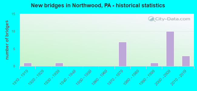
- New bridges - historical statistics
- 11910-1919
- 11930-1939
- 71970-1979
- 11990-1999
- 102000-2009
- 32010-2019

- Reconstructed bridges - Historical Statistics
- 11990-1999
- 32000-2009
- 32010-2019


- Bridge Condition - Deck
- 21.4%Very good
- 57.1%Good
- 7.1%Satisfactory
- 14.3%Fair

- Bridge Condition - Superstructure
- 33.3%Very good
- 40.0%Good
- 26.7%Fair

- Bridge Condition - Substructure
- 26.7%Very good
- 46.7%Good
- 13.3%Satisfactory
- 13.3%Fair

- Bridge Condition - Channel
- 55.6%Good
- 44.4%Satisfactory
Find on map >> Show street view
Structure Number: 5612, Location: .5 MI.N.OF TYRONE BORO. (Lat: 40.682458, Lng: -78.229547), Route carried "on" structure: State highway , Year Built: 1974, Year Reconstructed: 2001, Status: Open, Structure Length: 7.25m (23.79ft), Average Daily Traffic: 67 (year 2021), Truck Traffic: 6%, Average Future Daily Traffic: 85 (year 2032), Design Load: HS 20, Features Intersected: I-99 / US 220, Facility Carried by Structure: T516 MCCOY ST
Minimum Vertical Clearance: 30+ m (98+ ft), Kilometerpoint: 0.000, Lanes on structure: 2, Lanes under structure: 4, Owner: State Highway Agency, Approaching Roadway Width: 11.0m (36.1ft), Material/Design: Prestressed concrete, Design/Construction: Stringer/Multi-beam, Number Of Spans In Main Unit: 3, Length of Maximum Span: 23.5m (77.1ft), Curb or Sidewalk Widths: Left: 1.5m (4.9ft), Right: 0.2m (0.7ft), Curb-To-Curb Width: 11.0m (36.1ft), Out-to-Out Width: 13.5m (44.3ft)
Condition: Deck: Fair, Superstructure: Fair, Substructure: Fair, Operating Rating: 54.4 metric tons, Method Used To Determine Operating Rating: Load Factor (LF), Inventory Rating: 21.8 metric tons, Method Used To Determine Inventory Rating: Load Factor (LF), Structural Evaluation: Somewhat better than minimum adequacy, Deck Geometry: Superior to present desirable criteria, Underclear: Meets minimum limits, Approach Roadway Alignment: Equal to present desirable criteria, Length Of Structure Improvement: 9.10m (29.86ft), Designated Inspection Frequency: Every 24 months, Inspection Date: May 2021, Bridge Improvement Cost: $223,000, Roadway Improvement Cost: $656,000, Total Project Cost: $3,007,000, Deck Structure Type: Concrete Cast-file-Place, Wearing Surface/Protective System: Wearing Surface: Monolithic Concrete
Find on map >> Show street view
Structure Number: 5625, Location: BALD EAGLE (Lat: 40.722556, Lng: -78.183850), Route carried "on" structure: US 220B, Year Built: 1913, Year Reconstructed: 2016, Status: Open, Structure Length: 1.22m (4.00ft), Average Daily Traffic: 1,322 (year 2022), Truck Traffic: 6%, Average Future Daily Traffic: 1,963 (year 2032), Design Load: H 15, Features Intersected: BIG FILL RUN, Facility Carried by Structure: SR 4027
Minimum Vertical Clearance: 30+ m (98+ ft), Kilometerpoint: 11.618, Lanes on structure: 2, Owner: State Highway Agency, Approaching Roadway Width: 11.6m (38.1ft), Material/Design: Concrete, Design/Construction: Arch - Deck, Number Of Spans In Main Unit: 1, Length of Maximum Span: 12.2m (40.0ft), Curb-To-Curb Width: 11.7m (38.4ft), Out-to-Out Width: 12.4m (40.7ft)
Condition: Superstructure: Good, Substructure: Good, Channel: Satisfactory, Operating Rating: 74.4 metric tons, Method Used To Determine Operating Rating: Field evaluation and documented engineering judgment, Inventory Rating: 44.5 metric tons, Method Used To Determine Inventory Rating: Field evaluation and documented engineering judgment, Structural Evaluation: Better than present minimum criteria, Deck Geometry: Equal to present minimum criteria, Waterway Adequacy: Equal to present desirable criteria, Approach Roadway Alignment: Equal to present desirable criteria, Length Of Structure Improvement: 1.50m (4.92ft), Designated Inspection Frequency: Every 24 months, Inspection Date: September 2020, Bridge Improvement Cost: $52,000, Roadway Improvement Cost: $264,000, Total Project Cost: $707,000
Find on map >> Show street view
Structure Number: 5629, Location: 1.5 MI.S.OF BALD EAGLE (Lat: 40.716433, Lng: -78.181456), Route carried "on" structure: State highway 350, Year Built: 1974, Year Reconstructed: 2010, Status: Open, Structure Length: 7.65m (25.10ft), Average Daily Traffic: 880 (year 2021), Truck Traffic: 6%, Average Future Daily Traffic: 1,616 (year 2032), Design Load: HS 20, Features Intersected: N&BE RR & BALD EAGLE CR
Minimum Vertical Clearance: 30+ m (98+ ft), Kilometerpoint: 2.242, Lanes on structure: 2, Owner: State Highway Agency, Approaching Roadway Width: 13.4m (44.0ft), Skew: 2 degrees, Material/Design: Prestressed concrete, Design/Construction: Box Beam or Girders - Single/Spread, Number Of Spans In Main Unit: 4, Length of Maximum Span: 21.9m (71.9ft), Curb or Sidewalk Widths: Left: 0.2m (0.7ft), Right: 0.2m (0.7ft), Curb-To-Curb Width: 13.4m (44.0ft), Out-to-Out Width: 14.6m (47.9ft)
Condition: Deck: Satisfactory, Superstructure: Fair, Substructure: Satisfactory, Channel: Good, Operating Rating: 73.5 metric tons, Method Used To Determine Operating Rating: Load Factor (LF), Inventory Rating: 31.8 metric tons, Method Used To Determine Inventory Rating: Load Factor (LF), Structural Evaluation: Somewhat better than minimum adequacy, Deck Geometry: Superior to present desirable criteria, Underclear: High priority of corrective action, Waterway Adequacy: Superior to present desirable criteria, Approach Roadway Alignment: Equal to present desirable criteria, Length Of Structure Improvement: 8.60m (28.22ft), Designated Inspection Frequency: Every 24 months, Inspection Date: January 2021, Deck Structure Type: Concrete Cast-file-Place, Wearing Surface/Protective System: Wearing Surface: Latex Concrete
Find on map >> Show street view
Structure Number: 563, Location: 1.2 MI.S.OF BALD EAGLE (Lat: 40.718158, Lng: -78.185014), Route carried "on" structure: State highway 350, Year Built: 1973, Year Reconstructed: 2010, Status: Open, Structure Length: 1.74m (5.71ft), Average Daily Traffic: 880 (year 2021), Truck Traffic: 6%, Average Future Daily Traffic: 1,616 (year 2032), Design Load: HS 20, Features Intersected: BIG FILL RUN
Minimum Vertical Clearance: 30+ m (98+ ft), Kilometerpoint: 2.242, Lanes on structure: 2, Owner: State Highway Agency, Approaching Roadway Width: 7.3m (24.0ft), Skew: 2 degrees, Material/Design: Prestressed concrete, Design/Construction: Box Beam or Girders - Single/Spread, Number Of Spans In Main Unit: 1, Length of Maximum Span: 16.8m (55.1ft), Curb or Sidewalk Widths: Left: 0.2m (0.7ft), Right: 0.2m (0.7ft), Curb-To-Curb Width: 13.4m (44.0ft), Out-to-Out Width: 14.6m (47.9ft)
Condition: Deck: Good, Superstructure: Good, Substructure: Good, Channel: Satisfactory, Operating Rating: 95.3 metric tons, Method Used To Determine Operating Rating: Load Factor (LF), Inventory Rating: 37.2 metric tons, Method Used To Determine Inventory Rating: Load Factor (LF), Structural Evaluation: Better than present minimum criteria, Deck Geometry: Superior to present desirable criteria, Waterway Adequacy: Equal to present desirable criteria, Approach Roadway Alignment: Equal to present desirable criteria, Length Of Structure Improvement: 2.40m (7.87ft), Designated Inspection Frequency: Every 24 months, Inspection Date: June 2020, Deck Structure Type: Concrete Cast-file-Place, Wearing Surface/Protective System: Wearing Surface: Latex Concrete
Find on map >> Show street view
Structure Number: 5879, Location: 1.9 MILE SOUTH OF TR 350 (Lat: 40.704561, Lng: -78.212406), Route carried "on" structure: US 220B, Year Built: 1993, Status: Open, Structure Length: 2.87m (9.42ft), Average Daily Traffic: 3,183 (year 2021), Truck Traffic: 12%, Average Future Daily Traffic: 3,133 (year 2032), Design Load: HS 25 or greater, Features Intersected: BALD EAGLE CREEK, Facility Carried by Structure: SR 4027/BUS US 220
Minimum Vertical Clearance: 30+ m (98+ ft), Kilometerpoint: 8.407, Lanes on structure: 2, Owner: State Highway Agency, Approaching Roadway Width: 11.6m (38.1ft), Skew: 4 degrees, Material/Design: Prestressed concrete, Design/Construction: Box Beam or Girders - Single/Spread, Number Of Spans In Main Unit: 2, Length of Maximum Span: 13.7m (44.9ft), Curb or Sidewalk Widths: Left: 0.2m (0.7ft), Right: 0.2m (0.7ft), Curb-To-Curb Width: 12.2m (40.0ft), Out-to-Out Width: 13.3m (43.6ft)
Condition: Deck: Good, Superstructure: Good, Substructure: Good, Channel: Satisfactory, Operating Rating: 86.2 metric tons, Method Used To Determine Operating Rating: Load Factor (LF), Inventory Rating: 45.4 metric tons, Method Used To Determine Inventory Rating: Load Factor (LF), Structural Evaluation: Better than present minimum criteria, Deck Geometry: Equal to present minimum criteria, Waterway Adequacy: Equal to present minimum criteria, Approach Roadway Alignment: Equal to present desirable criteria, Length Of Structure Improvement: 3.60m (11.81ft), Designated Inspection Frequency: Every 48 months, Inspection Date: May 2019, Deck Structure Type: Concrete Cast-file-Place, Wearing Surface/Protective System: Wearing Surface: Monolithic Concrete, Deck Protection: Epoxy Coated Reinforcing
Find on map >> Show street view
Structure Number: 6019, Location: .6 MI.S.OF BALD EAGLE (Lat: 40.713194, Lng: -78.187703), Route carried "on" structure: State highway , Year Built: 1973, Year Reconstructed: 2007, Status: Open, Structure Length: 8.32m (27.30ft), Average Daily Traffic: 5,544 (year 2020), Truck Traffic: 29%, Average Future Daily Traffic: 9,359 (year 2032), Design Load: HS 20, Features Intersected: BALD EAGLE CREEK, Facility Carried by Structure: SR 4041
Minimum Vertical Clearance: 30+ m (98+ ft), Kilometerpoint: 0.000, Lanes on structure: 2, Owner: State Highway Agency, Approaching Roadway Width: 18.6m (61.0ft), Skew: 24 degrees, Material/Design: Prestressed concrete, Design/Construction: Stringer/Multi-beam, Number Of Spans In Main Unit: 3, Length of Maximum Span: 26.8m (87.9ft), Curb or Sidewalk Widths: Left: 0.2m (0.7ft), Right: 0.2m (0.7ft), Curb-To-Curb Width: 18.3m (60.0ft), Out-to-Out Width: 19.5m (64.0ft)
Condition: Deck: Good, Superstructure: Good, Substructure: Good, Channel: Good, Operating Rating: 77.1 metric tons, Method Used To Determine Operating Rating: Load Factor (LF), Inventory Rating: 27.2 metric tons, Method Used To Determine Inventory Rating: Load Factor (LF), Structural Evaluation: Equal to present minimum criteria, Deck Geometry: Superior to present desirable criteria, Waterway Adequacy: Superior to present desirable criteria, Approach Roadway Alignment: Equal to present desirable criteria, Length Of Structure Improvement: 9.30m (30.51ft), Designated Inspection Frequency: Every 24 months, Inspection Date: September 2020, Deck Structure Type: Concrete Cast-file-Place, Wearing Surface/Protective System: Wearing Surface: Latex Concrete
Find on map >> Show street view
Structure Number: 602, Location: .5 MI.S.OF BALD EAGLE (Lat: 40.715000, Lng: -78.196667), Route carried "on" structure: State highway , Year Built: 1973, Year Reconstructed: 2007, Status: Open, Structure Length: 5.12m (16.80ft), Average Daily Traffic: 5,544 (year 2020), Truck Traffic: 29%, Average Future Daily Traffic: 9,359 (year 2032), Design Load: HS 20, Features Intersected: Nittany & Bald Eagle RR, Facility Carried by Structure: SR 4041
Minimum Vertical Clearance: 30+ m (98+ ft), Kilometerpoint: 0.000, Lanes on structure: 2, Owner: State Highway Agency, Approaching Roadway Width: 18.6m (61.0ft), Skew: 23 degrees, Material/Design: Prestressed concrete, Design/Construction: Box Beam or Girders - Single/Spread, Number Of Spans In Main Unit: 3, Length of Maximum Span: 17.4m (57.1ft), Curb or Sidewalk Widths: Left: 0.2m (0.7ft), Right: 0.2m (0.7ft), Curb-To-Curb Width: 18.3m (60.0ft), Out-to-Out Width: 19.5m (64.0ft)
Condition: Deck: Good, Superstructure: Fair, Substructure: Fair, Operating Rating: 69.9 metric tons, Method Used To Determine Operating Rating: Load Factor (LF), Inventory Rating: 32.7 metric tons, Method Used To Determine Inventory Rating: Load Factor (LF), Structural Evaluation: Somewhat better than minimum adequacy, Deck Geometry: Superior to present desirable criteria, Underclear: High priority of corrective action, Approach Roadway Alignment: Equal to present desirable criteria, Length Of Structure Improvement: 6.10m (20.01ft), Designated Inspection Frequency: Every 24 months, Inspection Date: October 2020, Deck Structure Type: Concrete Cast-file-Place, Wearing Surface/Protective System: Wearing Surface: Latex Concrete
Find on map >> Show street view
Structure Number: 18678, Location: 0.6 MILE NORTH OF SR 4025 (Lat: 40.681344, Lng: -78.192178), Route carried "on" structure: State highway 550, Year Built: 1930, Year Reconstructed: 2012, Status: Open, Structure Length: 0.98m (3.22ft), Average Daily Traffic: 2,309 (year 2022), Truck Traffic: 6%, Average Future Daily Traffic: 2,286 (year 2032), Design Load: H 15, Features Intersected: LOGAN SPRING RUN
Minimum Vertical Clearance: 30+ m (98+ ft), Kilometerpoint: 2.514, Lanes on structure: 2, Owner: State Highway Agency, Approaching Roadway Width: 7.9m (25.9ft), Skew: 3 degrees, Material/Design: Concrete, Design/Construction: Tee Beam, Number Of Spans In Main Unit: 1, Length of Maximum Span: 9.1m (29.9ft), Curb or Sidewalk Widths: Left: 0.1m (0.3ft), Right: 0.0m, Curb-To-Curb Width: 7.0m (23.0ft), Out-to-Out Width: 7.9m (25.9ft)
Condition: Deck: Fair, Superstructure: Fair, Substructure: Satisfactory, Channel: Satisfactory, Operating Rating: 51.7 metric tons, Method Used To Determine Operating Rating: Load Factor (LF), Inventory Rating: 30.8 metric tons, Method Used To Determine Inventory Rating: Load Factor (LF), Structural Evaluation: Somewhat better than minimum adequacy, Deck Geometry: High priority of replacement, Waterway Adequacy: Equal to present desirable criteria, Approach Roadway Alignment: Somewhat better than minimum adequacy, Length Of Structure Improvement: 1.20m (3.94ft), Designated Inspection Frequency: Every 24 months, Inspection Date: November 2021, Bridge Improvement Cost: $47,000, Roadway Improvement Cost: $264,000, Total Project Cost: $638,000, Deck Structure Type: Concrete Cast-file-Place, Wearing Surface/Protective System: Wearing Surface: Bituminous, Membrane: Preformed Fabric
Find on map >> Show street view
Structure Number: 44178, Location: 0.7 MI S OF BALD EAGLE (Lat: 40.710911, Lng: -78.188394), Route carried "on" structure: Interstate 99, Year Built: 2006, Status: Open, Structure Length: 3.99m (13.09ft), Average Daily Traffic: 7,473 (year 2021), Truck Traffic: 18%, Average Future Daily Traffic: 7,485 (year 2032), Design Load: HL 93, Features Intersected: SR 4041
Minimum Vertical Clearance: 30+ m (98+ ft), Kilometerpoint: 59.671, Lanes on structure: 2, Lanes under structure: 2, Base Highway Network: Yes, Owner: State Highway Agency, Approaching Roadway Width: 11.6m (38.1ft), Skew: 11 degrees, Material/Design: Prestressed concrete, Design/Construction: Stringer/Multi-beam, Number Of Spans In Main Unit: 1, Length of Maximum Span: 38.1m (125.0ft), Curb or Sidewalk Widths: Left: 0.2m (0.7ft), Right: 0.2m (0.7ft), Curb-To-Curb Width: 12.2m (40.0ft), Out-to-Out Width: 13.1m (43.0ft)
Condition: Deck: Good, Superstructure: Very good, Substructure: Good, Operating Rating: 88.0 metric tons, Method Used To Determine Operating Rating: Load and Resistance Factor (LRFR), Inventory Rating: 44.5 metric tons, Method Used To Determine Inventory Rating: Load and Resistance Factor (LRFR), Structural Evaluation: Better than present minimum criteria, Deck Geometry: Better than present minimum criteria, Underclear: Equal to present minimum criteria, Approach Roadway Alignment: Equal to present desirable criteria, Designated Inspection Frequency: Every 48 months, Inspection Date: January 2020, Deck Structure Type: Concrete Cast-file-Place, Wearing Surface/Protective System: Wearing Surface: Monolithic Concrete, Deck Protection: Epoxy Coated Reinforcing
Find on map >> Show street view
Structure Number: 44179, Location: 0.7 MI. S. OF BALD EAGLE (Lat: 40.711406, Lng: -78.188022), Route carried "on" structure: Interstate 99, Year Built: 2006, Status: Open, Structure Length: 4.57m (14.99ft), Average Daily Traffic: 7,507 (year 2021), Truck Traffic: 19%, Average Future Daily Traffic: 8,638 (year 2032), Design Load: HL 93, Features Intersected: SR 4041
Minimum Vertical Clearance: 30+ m (98+ ft), Kilometerpoint: 59.681, Lanes on structure: 2, Lanes under structure: 2, Base Highway Network: Yes, Owner: State Highway Agency, Approaching Roadway Width: 11.6m (38.1ft), Skew: 12 degrees, Material/Design: Prestressed concrete, Design/Construction: Stringer/Multi-beam, Number Of Spans In Main Unit: 1, Length of Maximum Span: 43.9m (144.0ft), Curb or Sidewalk Widths: Left: 0.2m (0.7ft), Right: 0.2m (0.7ft), Curb-To-Curb Width: 12.2m (40.0ft), Out-to-Out Width: 13.1m (43.0ft)
Condition: Deck: Good, Superstructure: Good, Substructure: Good, Inventory Rating: 47.2 metric tons, Method Used To Determine Inventory Rating: Load and Resistance Factor (LRFR), Structural Evaluation: Better than present minimum criteria, Deck Geometry: Better than present minimum criteria, Underclear: Equal to present minimum criteria, Approach Roadway Alignment: Equal to present desirable criteria, Designated Inspection Frequency: Every 48 months, Inspection Date: January 2020, Deck Structure Type: Concrete Cast-file-Place, Wearing Surface/Protective System: Wearing Surface: Monolithic Concrete, Deck Protection: Epoxy Coated Reinforcing
Find on map >> Show street view
Structure Number: 4418, Location: 1.07 MI NORTH OF EXIT 52 (Lat: 40.715489, Lng: -78.178708), Route carried "on" structure: Interstate 99, Year Built: 2006, Status: Open, Structure Length: 8.63m (28.31ft), Average Daily Traffic: 7,473 (year 2021), Truck Traffic: 18%, Average Future Daily Traffic: 7,485 (year 2032), Design Load: HL 93, Features Intersected: SR 0350
Minimum Vertical Clearance: 30+ m (98+ ft), Kilometerpoint: 60.449, Lanes on structure: 2, Lanes under structure: 2, Base Highway Network: Yes, Owner: State Highway Agency, Approaching Roadway Width: 12.2m (40.0ft), Skew: 13 degrees, Material/Design: Prestressed concrete, Design/Construction: Stringer/Multi-beam, Number Of Spans In Main Unit: 3, Length of Maximum Span: 41.1m (134.8ft), Curb or Sidewalk Widths: Left: 0.2m (0.7ft), Right: 0.2m (0.7ft), Curb-To-Curb Width: 12.2m (40.0ft), Out-to-Out Width: 13.1m (43.0ft)
Condition: Deck: Good, Superstructure: Good, Substructure: Very good, Operating Rating: 73.5 metric tons, Method Used To Determine Operating Rating: Load and Resistance Factor (LRFR), Inventory Rating: 42.6 metric tons, Method Used To Determine Inventory Rating: Load and Resistance Factor (LRFR), Structural Evaluation: Better than present minimum criteria, Deck Geometry: Better than present minimum criteria, Underclear: Superior to present desirable criteria, Approach Roadway Alignment: Equal to present desirable criteria, Designated Inspection Frequency: Every 48 months, Inspection Date: September 2020, Deck Structure Type: Concrete Cast-file-Place, Wearing Surface/Protective System: Wearing Surface: Monolithic Concrete, Deck Protection: Epoxy Coated Reinforcing
Find on map >> Show street view
Structure Number: 44181, Location: 1.07 MI NORTH OF EXIT 52 (Lat: 40.715681, Lng: -78.178869), Route carried "on" structure: Interstate 99, Year Built: 2006, Status: Open, Structure Length: 7.50m (24.61ft), Average Daily Traffic: 7,507 (year 2021), Truck Traffic: 19%, Average Future Daily Traffic: 8,638 (year 2032), Design Load: HL 93, Features Intersected: SR 0350
Minimum Vertical Clearance: 30+ m (98+ ft), Kilometerpoint: 60.455, Lanes on structure: 2, Lanes under structure: 2, Base Highway Network: Yes, Owner: State Highway Agency, Approaching Roadway Width: 12.2m (40.0ft), Skew: 13 degrees, Material/Design: Prestressed concrete, Design/Construction: Stringer/Multi-beam, Number Of Spans In Main Unit: 3, Length of Maximum Span: 35.7m (117.1ft), Curb or Sidewalk Widths: Left: 0.2m (0.7ft), Right: 0.2m (0.7ft), Curb-To-Curb Width: 12.2m (40.0ft), Out-to-Out Width: 13.1m (43.0ft)
Condition: Deck: Good, Superstructure: Very good, Substructure: Very good, Operating Rating: 66.2 metric tons, Method Used To Determine Operating Rating: Load and Resistance Factor (LRFR), Inventory Rating: 43.5 metric tons, Method Used To Determine Inventory Rating: Load and Resistance Factor (LRFR), Structural Evaluation: Equal to present desirable criteria, Deck Geometry: Better than present minimum criteria, Underclear: Superior to present desirable criteria, Approach Roadway Alignment: Equal to present desirable criteria, Designated Inspection Frequency: Every 24 months, Inspection Date: September 2020, Deck Structure Type: Concrete Cast-file-Place, Wearing Surface/Protective System: Wearing Surface: Monolithic Concrete, Deck Protection: Epoxy Coated Reinforcing
Find on map >> Show street view
Structure Number: 48946, Location: 1Mi NW of Bald Eagle (Lat: 40.738064, Lng: -78.193733), Route carried "on" structure: City street , Year Built: 2014, Status: Open, Structure Length: 1.22m (4.00ft), Average Daily Traffic: 109 (year 2020), Truck Traffic: 10%, Average Future Daily Traffic: 133 (year 2040), Design Load: HL 93, Features Intersected: Big Fill Run, Facility Carried by Structure: T606,Bald Eagle SP
Minimum Vertical Clearance: 30+ m (98+ ft), Kilometerpoint: 0.000, Lanes on structure: 2, Owner: Town or Township Highway Agency, Approaching Roadway Width: 4.0m (13.1ft), Material/Design: Prestressed concrete, Design/Construction: Slab, Number Of Spans In Main Unit: 1, Length of Maximum Span: 11.0m (36.1ft), Curb-To-Curb Width: 6.8m (22.3ft), Out-to-Out Width: 7.4m (24.3ft)
Condition: Deck: Very good, Superstructure: Very good, Substructure: Good, Channel: Good, Operating Rating: 44.1 metric tons, Method Used To Determine Operating Rating: Assigned ratings based on Load and Resistance Factor Design (LRFD) reported by rating factor (RF) using HL93 loadings, Inventory Rating: 34.0 metric tons, Method Used To Determine Inventory Rating: Assigned ratings based on Load and Resistance Factor Design (LRFD) reported by rating factor (RF) using HL93 loadings, Structural Evaluation: Better than present minimum criteria, Deck Geometry: Meets minimum limits, Waterway Adequacy: Better than present minimum criteria, Approach Roadway Alignment: Equal to present desirable criteria, Designated Inspection Frequency: Every 24 months, Inspection Date: November 2020, Deck Structure Type: Concrete Cast-file-Place, Wearing Surface/Protective System: Wearing Surface: Monolithic Concrete, Deck Protection: Epoxy Coated Reinforcing
Find on map >> Show street view
Structure Number: 52785, Location: 0.4 MILE NORTH OF TR 453 (Lat: 40.680772, Lng: -78.233919), Route carried "on" structure: US 220B, Year Built: 2015, Status: Open, Structure Length: 2.93m (9.61ft), Average Daily Traffic: 3,183 (year 2021), Truck Traffic: 12%, Average Future Daily Traffic: 3,799 (year 2035), Design Load: HL 93, Features Intersected: BALD EAGLE CREEK, Facility Carried by Structure: SR 4027/BUS US 220
Minimum Vertical Clearance: 30+ m (98+ ft), Kilometerpoint: 5.235, Lanes on structure: 2, Owner: State Highway Agency, Approaching Roadway Width: 8.8m (28.9ft), Skew: 2 degrees, Material/Design: Prestressed concrete, Design/Construction: Stringer/Multi-beam, Number Of Spans In Main Unit: 1, Length of Maximum Span: 27.7m (90.9ft), Curb or Sidewalk Widths: Left: 0.2m (0.7ft), Right: 0.2m (0.7ft), Curb-To-Curb Width: 9.1m (29.9ft), Out-to-Out Width: 10.3m (33.8ft)
Condition: Deck: Very good, Superstructure: Very good, Substructure: Very good, Channel: Good, Operating Rating: 52.2 metric tons, Method Used To Determine Operating Rating: Assigned ratings based on Load and Resistance Factor Design (LRFD) reported by rating factor (RF) using HL93 loadings, Inventory Rating: 40.2 metric tons, Method Used To Determine Inventory Rating: Assigned ratings based on Load and Resistance Factor Design (LRFD) reported by rating factor (RF) using HL93 loadings, Structural Evaluation: Equal to present desirable criteria, Deck Geometry: Meets minimum limits, Waterway Adequacy: Equal to present minimum criteria, Approach Roadway Alignment: Meets minimum limits, Length Of Structure Improvement: 2.93m (9.61ft), Designated Inspection Frequency: Every 24 months, Inspection Date: August 2021, Deck Structure Type: Concrete Cast-file-Place, Wearing Surface/Protective System: Wearing Surface: Monolithic Concrete, Deck Protection: Epoxy Coated Reinforcing
Find on map >> Show street view
Structure Number: 53627, Location: 1.0 MILE SOUTH OF TR 350 (Lat: 40.712847, Lng: -78.200844), Route carried "on" structure: US 220B, Year Built: 2016, Status: Open, Structure Length: 1.40m (4.59ft), Average Daily Traffic: 3,183 (year 2021), Truck Traffic: 12%, Average Future Daily Traffic: 3,757 (year 2036), Design Load: HL 93, Features Intersected: VANSCOYOC RUN, Facility Carried by Structure: SR 4027
Minimum Vertical Clearance: 30+ m (98+ ft), Kilometerpoint: 9.962, Lanes on structure: 2, Owner: State Highway Agency, Approaching Roadway Width: 8.5m (27.9ft), Skew: 3 degrees, Material/Design: Prestressed concrete, Design/Construction: Box Beam or Girders - Single/Spread, Number Of Spans In Main Unit: 1, Length of Maximum Span: 13.4m (44.0ft), Curb or Sidewalk Widths: Left: 0.2m (0.7ft), Right: 0.2m (0.7ft), Curb-To-Curb Width: 8.5m (27.9ft), Out-to-Out Width: 9.6m (31.5ft)
Condition: Deck: Very good, Superstructure: Very good, Substructure: Very good, Channel: Good, Operating Rating: 45.0 metric tons, Method Used To Determine Operating Rating: Assigned ratings based on Load and Resistance Factor Design (LRFD) reported by rating factor (RF) using HL93 loadings, Inventory Rating: 34.7 metric tons, Method Used To Determine Inventory Rating: Assigned ratings based on Load and Resistance Factor Design (LRFD) reported by rating factor (RF) using HL93 loadings, Structural Evaluation: Equal to present desirable criteria, Deck Geometry: Meets minimum limits, Waterway Adequacy: Equal to present minimum criteria, Approach Roadway Alignment: Equal to present desirable criteria, Designated Inspection Frequency: Every 24 months, Inspection Date: September 2020, Deck Structure Type: Concrete Cast-file-Place, Wearing Surface/Protective System: Wearing Surface: Monolithic Concrete, Deck Protection: Epoxy Coated Reinforcing
Find on map >> Show street view
Structure Number: 5612, Location: .5 MI.N.OF TYRONE BORO. (Lat: 40.682458, Lng: -78.229547), Route carried "under" structure: Interstate 99, Year Built: 1974, Structure Length: 0. m, Average Daily Traffic: 9,461 (year 2021), Truck Traffic: 20%, Features Intersected: I-99 / US 220, Facility Carried by Structure: T516 MCCOY ST
Minimum Vertical Clearance: 7.62m (25.00ft), Kilometerpoint: 54.850, Lanes on structure: 2, Lanes under structure: 2, Material/Design: Prestressed concrete, Design/Construction: Stringer/Multi-beam, Length of Maximum Span: 23.5m (77.1ft)
Find on map >> Show street view
Structure Number: 5612, Location: .5 MI.N.OF TYRONE BORO. (Lat: 40.682458, Lng: -78.229547), Route carried "under" structure: Interstate 99, Year Built: 1974, Structure Length: 0. m, Average Daily Traffic: 10,259 (year 2021), Truck Traffic: 21%, Features Intersected: I-99 / US 220, Facility Carried by Structure: T516 MCCOY ST
Minimum Vertical Clearance: 5.33m (17.49ft), Kilometerpoint: 54.853, Lanes on structure: 2, Lanes under structure: 2, Material/Design: Prestressed concrete, Design/Construction: Stringer/Multi-beam, Length of Maximum Span: 23.5m (77.1ft)
Find on map >> Show street view
Structure Number: 44178, Location: 0.7 MI S OF BALD EAGLE (Lat: 40.710911, Lng: -78.188394), Route carried "under" structure: State highway , Year Built: 2006, Structure Length: 0. m, Average Daily Traffic: 2,690 (year 2020), Truck Traffic: 28%, Features Intersected: SR 4041, Facility Carried by Structure: I-99 / US 220 NBL
Minimum Vertical Clearance: 5.61m (18.41ft), Kilometerpoint: 0.000, Lanes on structure: 2, Lanes under structure: 1, Material/Design: Prestressed concrete, Design/Construction: Stringer/Multi-beam, Length of Maximum Span: 38.1m (125.0ft)
Find on map >> Show street view
Structure Number: 44178, Location: 0.7 MI S OF BALD EAGLE (Lat: 40.710911, Lng: -78.188394), Route carried "under" structure: State highway , Year Built: 2006, Structure Length: 0. m, Average Daily Traffic: 2,854 (year 2020), Truck Traffic: 29%, Features Intersected: SR 4041, Facility Carried by Structure: I-99 / US 220 NBL
Minimum Vertical Clearance: 5.21m (17.09ft), Kilometerpoint: 0.000, Lanes on structure: 2, Lanes under structure: 1, Material/Design: Prestressed concrete, Design/Construction: Stringer/Multi-beam, Length of Maximum Span: 38.1m (125.0ft)
Find on map >> Show street view
Structure Number: 44179, Location: 0.7 MI. S. OF BALD EAGLE (Lat: 40.711406, Lng: -78.188022), Route carried "under" structure: State highway , Year Built: 2006, Structure Length: 0. m, Average Daily Traffic: 2,690 (year 2020), Truck Traffic: 28%, Features Intersected: SR 4041, Facility Carried by Structure: I-99 / US 220 SBL
Minimum Vertical Clearance: 5.74m (18.83ft), Kilometerpoint: 0.000, Lanes on structure: 2, Lanes under structure: 1, Material/Design: Prestressed concrete, Design/Construction: Stringer/Multi-beam, Length of Maximum Span: 43.9m (144.0ft)
Find on map >> Show street view
Structure Number: 44179, Location: 0.7 MI. S. OF BALD EAGLE (Lat: 40.711406, Lng: -78.188022), Route carried "under" structure: State highway , Year Built: 2006, Structure Length: 0. m, Average Daily Traffic: 2,854 (year 2020), Truck Traffic: 29%, Features Intersected: SR 4041, Facility Carried by Structure: I-99 / US 220 SBL
Minimum Vertical Clearance: 5.33m (17.49ft), Kilometerpoint: 0.000, Lanes on structure: 2, Lanes under structure: 1, Material/Design: Prestressed concrete, Design/Construction: Stringer/Multi-beam, Length of Maximum Span: 43.9m (144.0ft)
Find on map >> Show street view
Structure Number: 4418, Location: 1.07 MI NORTH OF EXIT 52 (Lat: 40.715489, Lng: -78.178708), Route carried "under" structure: State highway 350, Year Built: 2006, Structure Length: 0. m, Average Daily Traffic: 880 (year 2021), Truck Traffic: 6%, Features Intersected: SR 0350, Facility Carried by Structure: I-99 / US 220 NBL
Minimum Vertical Clearance: 6.91m (22.67ft), Kilometerpoint: 1.246, Lanes on structure: 2, Lanes under structure: 2, Material/Design: Prestressed concrete, Design/Construction: Stringer/Multi-beam, Length of Maximum Span: 41.1m (134.8ft)
Find on map >> Show street view
Structure Number: 44181, Location: 1.07 MI NORTH OF EXIT 52 (Lat: 40.715681, Lng: -78.178869), Route carried "under" structure: State highway 350, Year Built: 2006, Structure Length: 0. m, Average Daily Traffic: 880 (year 2021), Truck Traffic: 6%, Features Intersected: SR 0350, Facility Carried by Structure: I-99 / US 220 SBL
Minimum Vertical Clearance: 7.11m (23.33ft), Kilometerpoint: 1.246, Lanes on structure: 2, Lanes under structure: 2, Material/Design: Prestressed concrete, Design/Construction: Stringer/Multi-beam, Length of Maximum Span: 35.7m (117.1ft)