Bridge Statistics for Oak Park, Michigan (MI)
Condition, Traffic, Stress, Structural Evaluation, Project Costs
- National Bridge Inventory (NBI) Statistics
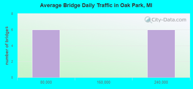
- 12Number of bridges
- 121ft / 36.8mTotal length
- 1,132,658Total average daily traffic
- 48,473Total average daily truck traffic
- National Bridge Inventory (NBI) Registered Bridges for Oak Park
- No street view available for this location
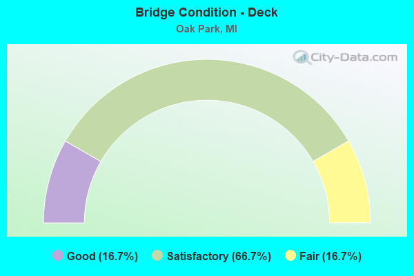
- Bridge Condition - Deck
- 16.7%Good
- 66.7%Satisfactory
- 16.7%Fair
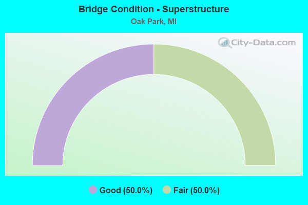
- Bridge Condition - Superstructure
- 50.0%Good
- 50.0%Fair
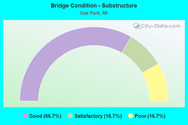
- Bridge Condition - Substructure
- 66.7%Good
- 16.7%Satisfactory
- 16.7%Poor
Find on map >> Show street view
Structure Number: 7931, Location: IN OAK PARK (Lat: 42.474842, Lng: -83.187750), Route carried "on" structure: County highway 2059, Year Built: 1985, Status: Open, Structure Length: 12.55m (41.17ft), Average Daily Traffic: 1,500 (year 1982), Truck Traffic: 3%, Average Future Daily Traffic: 1,500 (year 1977), Design Load: HS 20, Features Intersected: I-696, Facility Carried by Structure: 10 MILE ROAD W-SER
Minimum Vertical Clearance: 30.48m (100.00ft), Kilometerpoint: 0.225, Lanes on structure: 2, Lanes under structure: 10, Owner: State Highway Agency, Approaching Roadway Width: 10.3m (33.8ft), Skew: 5 degrees, Material/Design: Steel continuous, Design/Construction: Stringer/Multi-beam, Number Of Spans In Main Unit: 2, Length of Maximum Span: 66.7m (218.8ft), Curb or Sidewalk Widths: Left: 2.4m (7.9ft), Right: 0.2m (0.7ft), Curb-To-Curb Width: 9.4m (30.8ft), Out-to-Out Width: 12.9m (42.3ft)
Condition: Deck: Good, Superstructure: Good, Substructure: Good, Operating Rating: 82.0 metric tons, Method Used To Determine Operating Rating: Load Factor (LF) rating reported by rating factor (RF) method using MS18 loading, Inventory Rating: 49.2 metric tons, Method Used To Determine Inventory Rating: Load Factor (LF) rating reported by rating factor (RF) method using MS18 loading, Structural Evaluation: Better than present minimum criteria, Deck Geometry: Somewhat better than minimum adequacy, Underclear: Somewhat better than minimum adequacy, Approach Roadway Alignment: Equal to present desirable criteria, Designated Inspection Frequency: Every 24 months, Inspection Date: July 2020, Deck Structure Type: Concrete Cast-file-Place, Wearing Surface/Protective System: Wearing Surface: Latex Concrete, Deck Protection: Epoxy Coated Reinforcing
Find on map >> Show street view
Structure Number: 7932, Location: W OF COOLIDGE HWY (Lat: 42.474417, Lng: -83.184275), Route carried "on" structure: City street 2059, Year Built: 1985, Status: Open, Structure Length: 4.72m (15.49ft), Average Daily Traffic: 1,500 (year 1982), Truck Traffic: 3%, Average Future Daily Traffic: 1,500 (year 1977), Design Load: HS 25 or greater, Features Intersected: I-696, Facility Carried by Structure: COOLIDGE ROAD U T
Minimum Vertical Clearance: 30.48m (100.00ft), Kilometerpoint: 0.027, Lanes on structure: 2, Lanes under structure: 8, Owner: State Highway Agency, Approaching Roadway Width: 14.6m (47.9ft), Skew: 30 degrees, Material/Design: Concrete continuous, Design/Construction: Tee Beam, Number Of Spans In Main Unit: 2, Length of Maximum Span: 23.8m (78.1ft), Curb-To-Curb Width: 12.8m (42.0ft), Out-to-Out Width: 17.1m (56.1ft)
Condition: Deck: Satisfactory, Superstructure: Fair, Substructure: Good, Operating Rating: 66.1 metric tons, Method Used To Determine Operating Rating: Load Factor (LF) rating reported by rating factor (RF) method using MS18 loading, Inventory Rating: 39.5 metric tons, Method Used To Determine Inventory Rating: Load Factor (LF) rating reported by rating factor (RF) method using MS18 loading, Structural Evaluation: Somewhat better than minimum adequacy, Deck Geometry: Better than present minimum criteria, Underclear: Equal to present minimum criteria, Approach Roadway Alignment: Equal to present desirable criteria, Designated Inspection Frequency: Every 24 months, Inspection Date: July 2020, Deck Structure Type: Concrete Cast-file-Place, Wearing Surface/Protective System: Wearing Surface: Monolithic Concrete, Deck Protection: Epoxy Coated Reinforcing
Find on map >> Show street view
Structure Number: 7933, Location: IN OAK PARK (Lat: 42.474467, Lng: -83.182594), Route carried "on" structure: City street 2059, Year Built: 1985, Status: Open, Structure Length: 4.69m (15.39ft), Average Daily Traffic: 8,000 (year 1982), Truck Traffic: 3%, Average Future Daily Traffic: 8,000 (year 1977), Design Load: HS 25 or greater, Features Intersected: I-696, Facility Carried by Structure: COOLIDGE ROAD
Minimum Vertical Clearance: 30.48m (100.00ft), Kilometerpoint: 3.254, Lanes on structure: 4, Lanes under structure: 8, Owner: State Highway Agency, Approaching Roadway Width: 14.6m (47.9ft), Material/Design: Prestressed concrete, Design/Construction: Stringer/Multi-beam, Number Of Spans In Main Unit: 2, Length of Maximum Span: 23.5m (77.1ft), Curb or Sidewalk Widths: Left: 2.4m (7.9ft), Right: 2.4m (7.9ft), Curb-To-Curb Width: 19.5m (64.0ft), Out-to-Out Width: 25.2m (82.7ft)
Condition: Deck: Satisfactory, Superstructure: Fair, Substructure: Poor, Operating Rating: 71.0 metric tons, Method Used To Determine Operating Rating: Load Factor (LF) rating reported by rating factor (RF) method using MS18 loading, Inventory Rating: 29.8 metric tons, Method Used To Determine Inventory Rating: Load Factor (LF) rating reported by rating factor (RF) method using MS18 loading, Structural Evaluation: Meets minimum limits, Deck Geometry: Better than present minimum criteria, Underclear: Equal to present minimum criteria, Approach Roadway Alignment: Superior to present desirable criteria, Designated Inspection Frequency: Every 24 months, Other Special Inspection Frequency: Every 24 months, Inspection Date: July 2020, Other Special Inspection Date: July 2021, Deck Structure Type: Concrete Cast-file-Place, Wearing Surface/Protective System: Wearing Surface: Monolithic Concrete, Deck Protection: Epoxy Coated Reinforcing
Find on map >> Show street view
Structure Number: 7952, Location: 0.2 MILES E. OF SCOTIA RD (Lat: 42.474928, Lng: -83.166353), Route carried "on" structure: City street , Year Built: 1985, Status: Open, Structure Length: 4.70m (15.42ft), Average Daily Traffic: 1,500 (year 1982), Truck Traffic: 3%, Average Future Daily Traffic: 1,500 (year 1977), Design Load: HS 25 or greater, Features Intersected: I-696, Facility Carried by Structure: MANISTEE U-TURN
Minimum Vertical Clearance: 30.48m (100.00ft), Kilometerpoint: 0.021, Lanes on structure: 2, Lanes under structure: 8, Owner: State Highway Agency, Approaching Roadway Width: 14.6m (47.9ft), Skew: 30 degrees, Material/Design: Prestressed concrete, Design/Construction: Stringer/Multi-beam, Number Of Spans In Main Unit: 2, Length of Maximum Span: 23.5m (77.1ft), Curb or Sidewalk Widths: Left: 2.7m (8.9ft), Right: 2.7m (8.9ft), Curb-To-Curb Width: 12.8m (42.0ft), Out-to-Out Width: 25.1m (82.3ft)
Condition: Deck: Satisfactory, Superstructure: Good, Substructure: Good, Operating Rating: 73.2 metric tons, Method Used To Determine Operating Rating: Load Factor (LF), Inventory Rating: 40.1 metric tons, Method Used To Determine Inventory Rating: Load Factor (LF), Structural Evaluation: Better than present minimum criteria, Deck Geometry: Better than present minimum criteria, Underclear: Equal to present minimum criteria, Approach Roadway Alignment: Equal to present desirable criteria, Designated Inspection Frequency: Every 24 months, Inspection Date: July 2020, Deck Structure Type: Concrete Cast-file-Place, Wearing Surface/Protective System: Wearing Surface: Monolithic Concrete, Deck Protection: Epoxy Coated Reinforcing
Find on map >> Show street view
Structure Number: 7953, Location: 0.7 MI W WOODWARD (Lat: 42.474331, Lng: -83.160108), Route carried "on" structure: ServiceCity street , Year Built: 1985, Status: Open, Structure Length: 4.69m (15.39ft), Average Daily Traffic: 1,500 (year 1982), Truck Traffic: 3%, Average Future Daily Traffic: 1,500 (year 1977), Design Load: HS 25 or greater, Features Intersected: I-696, Facility Carried by Structure: ROANOKE U-TURN
Minimum Vertical Clearance: 30.48m (100.00ft), Kilometerpoint: 0.031, Lanes on structure: 2, Lanes under structure: 8, Owner: State Highway Agency, Approaching Roadway Width: 14.6m (47.9ft), Skew: 30 degrees, Material/Design: Prestressed concrete, Design/Construction: Stringer/Multi-beam, Number Of Spans In Main Unit: 2, Length of Maximum Span: 23.5m (77.1ft), Curb or Sidewalk Widths: Left: 0.2m (0.7ft), Right: 0.2m (0.7ft), Curb-To-Curb Width: 12.8m (42.0ft), Out-to-Out Width: 17.1m (56.1ft)
Condition: Deck: Satisfactory, Superstructure: Good, Substructure: Good, Operating Rating: 59.6 metric tons, Method Used To Determine Operating Rating: Load Factor (LF) rating reported by rating factor (RF) method using MS18 loading, Inventory Rating: 32.7 metric tons, Method Used To Determine Inventory Rating: Load Factor (LF) rating reported by rating factor (RF) method using MS18 loading, Structural Evaluation: Better than present minimum criteria, Deck Geometry: Better than present minimum criteria, Underclear: High priority of corrective action, Approach Roadway Alignment: Equal to present desirable criteria, Designated Inspection Frequency: Every 24 months, Inspection Date: July 2020, Deck Structure Type: Concrete Cast-file-Place, Wearing Surface/Protective System: Wearing Surface: Monolithic Concrete, Deck Protection: Epoxy Coated Reinforcing
Find on map >> Show street view
Structure Number: 7961, Location: 0.5 MI E OF GREENFIELD (Lat: 42.475856, Lng: -83.190736), Route carried "on" structure: City street , Year Built: 1984, Status: Posted for load, Structure Length: 5.43m (17.81ft), Average Daily Traffic: 5,983 (year 2010), Average Future Daily Traffic: 6,880 (year 2030), Features Intersected: I-696, Facility Carried by Structure: PLAZA & CHURCH ST
Minimum Vertical Clearance: 30.48m (100.00ft), Kilometerpoint: 1.363, Lanes on structure: 2, Lanes under structure: 10, Owner: State Highway Agency, Approaching Roadway Width: 8.5m (27.9ft), Skew: 3 degrees, Material/Design: Prestressed concrete, Design/Construction: Box Beam or Girders - Multiple, Number Of Spans In Main Unit: 2, Length of Maximum Span: 26.6m (87.3ft), Curb or Sidewalk Widths: Left: 0.0m, Right: 3.0m (9.8ft), Curb-To-Curb Width: 8.5m (27.9ft), Out-to-Out Width: 213.8m (701.4ft)
Condition: Deck: Fair, Superstructure: Fair, Substructure: Satisfactory, Operating Rating: 25.6 metric tons, Method Used To Determine Operating Rating: Load Factor (LF) rating reported by rating factor (RF) method using MS18 loading, Inventory Rating: 15.2 metric tons, Method Used To Determine Inventory Rating: Load Factor (LF) rating reported by rating factor (RF) method using MS18 loading, Structural Evaluation: High priority of corrective action, Deck Geometry: High priority of replacement, Underclear: Equal to present minimum criteria, Approach Roadway Alignment: Equal to present minimum criteria, Bridge Posting: Required (Relationship of Operating Rating to Maximum Legal Load: > 39.9% below), Designated Inspection Frequency: Every 24 months, Inspection Date: June 2021, Deck Structure Type: Concrete Precast Panels, Wearing Surface/Protective System: Wearing Surface: Bituminous, Membrane: Other
Find on map >> Show street view
Structure Number: 7931, Location: IN OAK PARK (Lat: 42.474842, Lng: -83.187750), Route carried "under" structure: Interstate 696, Year Built: 1985, Structure Length: 0. m, Average Daily Traffic: 188,900 (year 2007), Truck Traffic: 4%, Features Intersected: I-696, Facility Carried by Structure: 10 MILE ROAD W-SER
Minimum Vertical Clearance: 5.66m (18.57ft), Kilometerpoint: 1.078, Lanes on structure: 2, Lanes under structure: 10, Material/Design: Steel continuous, Design/Construction: Stringer/Multi-beam, Length of Maximum Span: 66.7m (218.8ft)
Find on map >> Show street view
Structure Number: 7932, Location: W OF COOLIDGE HWY (Lat: 42.474417, Lng: -83.184275), Route carried "under" structure: Interstate 696, Year Built: 1985, Structure Length: 0. m, Average Daily Traffic: 188,900 (year 2007), Truck Traffic: 4%, Features Intersected: I-696, Facility Carried by Structure: COOLIDGE ROAD U T
Minimum Vertical Clearance: 5.23m (17.16ft), Kilometerpoint: 1.411, Lanes on structure: 2, Lanes under structure: 8, Material/Design: Concrete continuous, Design/Construction: Tee Beam, Length of Maximum Span: 23.8m (78.1ft)
Find on map >> Show street view
Structure Number: 7933, Location: IN OAK PARK (Lat: 42.474467, Lng: -83.182594), Route carried "under" structure: Interstate 696, Year Built: 1985, Structure Length: 0. m, Average Daily Traffic: 190,100 (year 2007), Truck Traffic: 4%, Features Intersected: I-696, Facility Carried by Structure: COOLIDGE ROAD
Minimum Vertical Clearance: 5.59m (18.34ft), Kilometerpoint: 1.550, Lanes on structure: 4, Lanes under structure: 8, Material/Design: Prestressed concrete, Design/Construction: Stringer/Multi-beam, Length of Maximum Span: 23.5m (77.1ft)
Find on map >> Show street view
Structure Number: 7952, Location: 0.2 MILES E. OF SCOTIA RD (Lat: 42.474928, Lng: -83.166353), Route carried "under" structure: Interstate 696, Year Built: 1985, Structure Length: 0. m, Average Daily Traffic: 190,100 (year 2007), Truck Traffic: 5%, Features Intersected: I-696, Facility Carried by Structure: MANISTEE U-TURN
Minimum Vertical Clearance: 5.72m (18.77ft), Kilometerpoint: 2.889, Lanes on structure: 2, Lanes under structure: 8, Material/Design: Prestressed concrete, Design/Construction: Stringer/Multi-beam, Length of Maximum Span: 23.5m (77.1ft)
Find on map >> Show street view
Structure Number: 7953, Location: 0.7 MI W WOODWARD (Lat: 42.474331, Lng: -83.160108), Route carried "under" structure: Interstate 696, Year Built: 1985, Structure Length: 0. m, Average Daily Traffic: 190,100 (year 2007), Truck Traffic: 4%, Features Intersected: I-696, Facility Carried by Structure: ROANOKE U-TURN
Minimum Vertical Clearance: 5.77m (18.93ft), Kilometerpoint: 3.402, Lanes on structure: 2, Lanes under structure: 8, Material/Design: Prestressed concrete, Design/Construction: Stringer/Multi-beam, Length of Maximum Span: 23.5m (77.1ft)
Find on map >> Show street view
Structure Number: 7961, Location: 0.5 MI E OF GREENFIELD (Lat: 42.475856, Lng: -83.190736), Route carried "under" structure: Interstate 696, Year Built: 1984, Structure Length: 0. m, Average Daily Traffic: 164,575 (year 2016), Truck Traffic: 5%, Features Intersected: I-696, Facility Carried by Structure: PLAZA & CHURCH ST
Minimum Vertical Clearance: 5.33m (17.49ft), Kilometerpoint: 0.690, Lanes on structure: 2, Lanes under structure: 10, Material/Design: Prestressed concrete, Design/Construction: Box Beam or Girders - Multiple, Length of Maximum Span: 26.6m (87.3ft)