Bridge Statistics for Oakdale, Pennsylvania (PA)
Condition, Traffic, Stress, Structural Evaluation, Project Costs
- National Bridge Inventory (NBI) Statistics
- 14Number of bridges
- 52ft / 15.9mTotal length
- $804,000Total costs
- 176,870Total average daily traffic
- 17,155Total average daily truck traffic
- National Bridge Inventory (NBI) Registered Bridges for Oakdale
- No street view available for this location
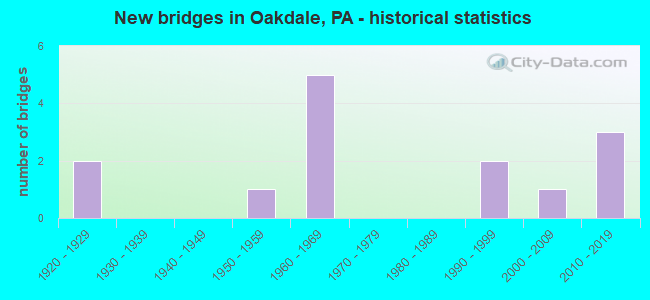
- New bridges - historical statistics
- 21920-1929
- 11950-1959
- 51960-1969
- 21990-1999
- 12000-2009
- 32010-2019

- Reconstructed bridges - Historical Statistics
- 11980-1989
- 01990-1999
- 02000-2009
- 12010-2019


- Bridge Condition - Deck
- 20.0%Very good
- 40.0%Good
- 40.0%Satisfactory

- Bridge Condition - Superstructure
- 33.3%Very good
- 16.7%Good
- 33.3%Satisfactory
- 16.7%Fair

- Bridge Condition - Substructure
- 33.3%Good
- 33.3%Satisfactory
- 16.7%Fair
- 16.7%Poor

- Bridge Condition - Channel
- 20.0%Good
- 60.0%Fair
- 20.0%Poor
Find on map >> Show street view
Structure Number: 552, Location: OVER SR 3103 (McKee Road) (Lat: 40.438747, Lng: -80.191825), Route carried "on" structure: US 22, Year Built: 1964, Year Reconstructed: 2015, Status: Open, Structure Length: 4.27m (14.01ft), Average Daily Traffic: 24,300 (year 2021), Truck Traffic: 13%, Average Future Daily Traffic: 24,650 (year 2032), Design Load: HS 20, Features Intersected: SR 3103- Mckee Road
Minimum Vertical Clearance: 30+ m (98+ ft), Kilometerpoint: 9.326, Lanes on structure: 4, Lanes under structure: 2, Base Highway Network: Yes, Owner: State Highway Agency, Approaching Roadway Width: 26.8m (87.9ft), Skew: 20 degrees, Material/Design: Steel continuous, Design/Construction: Stringer/Multi-beam, Number Of Spans In Main Unit: 3, Length of Maximum Span: 21.3m (69.9ft), Curb or Sidewalk Widths: Left: 0.2m (0.7ft), Right: 0.2m (0.7ft), Curb-To-Curb Width: 26.8m (87.9ft), Out-to-Out Width: 27.1m (88.9ft)
Condition: Deck: Good, Superstructure: Good, Substructure: Satisfactory, Operating Rating: 58.1 metric tons, Method Used To Determine Operating Rating: Load Factor (LF), Inventory Rating: 34.5 metric tons, Method Used To Determine Inventory Rating: Load Factor (LF), Structural Evaluation: Equal to present minimum criteria, Deck Geometry: Superior to present desirable criteria, Underclear: Better than present minimum criteria, Approach Roadway Alignment: Equal to present desirable criteria, Length Of Structure Improvement: 4.30m (14.11ft), Designated Inspection Frequency: Every 24 months, Inspection Date: October 2020, Bridge Improvement Cost: $38,000, Roadway Improvement Cost: $111,000, Total Project Cost: $510,000, Deck Structure Type: Concrete Cast-file-Place, Wearing Surface/Protective System: Wearing Surface: Latex Concrete, Deck Protection: Epoxy Coated Reinforcing
Find on map >> Show street view
Structure Number: 1349, Location: @ INTERS.W\SR 3048 (Lat: 40.397536, Lng: -80.185019), Route carried "on" structure: State highway 978, Year Built: 1925, Status: Open, Structure Length: 1.68m (5.51ft), Average Daily Traffic: 7,598 (year 2022), Truck Traffic: 6%, Average Future Daily Traffic: 5,819 (year 2032), Design Load: HS 20, Features Intersected: BR.ROBINSON RUN, Facility Carried by Structure: UNION AV
Minimum Vertical Clearance: 30+ m (98+ ft), Kilometerpoint: 8.504, Lanes on structure: 2, Owner: State Highway Agency, Approaching Roadway Width: 9.1m (29.9ft), Skew: 3 degrees, Material/Design: Concrete, Design/Construction: Arch - Deck, Number Of Spans In Main Unit: 1, Length of Maximum Span: 16.8m (55.1ft), Curb or Sidewalk Widths: Left: 2.3m (7.5ft), Right: 2.3m (7.5ft), Curb-To-Curb Width: 9.1m (29.9ft), Out-to-Out Width: 14.9m (48.9ft)
Condition: Superstructure: Fair, Substructure: Satisfactory, Channel: Fair, Operating Rating: 49.0 metric tons, Method Used To Determine Operating Rating: Field evaluation and documented engineering judgment, Inventory Rating: 32.7 metric tons, Method Used To Determine Inventory Rating: Field evaluation and documented engineering judgment, Structural Evaluation: Somewhat better than minimum adequacy, Deck Geometry: High priority of corrective action, Waterway Adequacy: Equal to present minimum criteria, Approach Roadway Alignment: Equal to present desirable criteria, Length Of Structure Improvement: 1.70m (5.58ft), Designated Inspection Frequency: Every 24 months, Inspection Date: October 2020, Bridge Improvement Cost: $9,000, Roadway Improvement Cost: $35,000, Total Project Cost: $125,000
Find on map >> Show street view
Structure Number: 1351, Location: 200' WEST OF SR 3063 (Lat: 40.409639, Lng: -80.193050), Route carried "on" structure: State highway 978, Year Built: 1953, Status: Open, Structure Length: 0.64m (2.10ft), Average Daily Traffic: 3,721 (year 2022), Truck Traffic: 9%, Average Future Daily Traffic: 3,830 (year 2032), Design Load: HS 20, Features Intersected: BR.NORTH BR.ROBINSON RUN, Facility Carried by Structure: CLINTON RD
Minimum Vertical Clearance: 30+ m (98+ ft), Kilometerpoint: 10.131, Lanes on structure: 2, Owner: State Highway Agency, Approaching Roadway Width: 8.2m (26.9ft), Material/Design: Prestressed concrete, Design/Construction: Box Beam or Girders - Multiple, Number Of Spans In Main Unit: 1, Length of Maximum Span: 5.5m (18.0ft), Curb-To-Curb Width: 10.7m (35.1ft), Out-to-Out Width: 11.1m (36.4ft)
Condition: Deck: Satisfactory, Superstructure: Satisfactory, Substructure: Poor, Channel: Poor, Inventory Rating: 54.4 metric tons, Method Used To Determine Inventory Rating: Load Factor (LF), Structural Evaluation: Meets minimum limits, Deck Geometry: Somewhat better than minimum adequacy, Waterway Adequacy: Equal to present minimum criteria, Approach Roadway Alignment: Equal to present desirable criteria, Length Of Structure Improvement: 0.60m (1.97ft), Designated Inspection Frequency: Every 24 months, Inspection Date: October 2020, Bridge Improvement Cost: $4,000, Roadway Improvement Cost: $20,000, Total Project Cost: $57,000, Deck Structure Type: Other, Wearing Surface/Protective System: Wearing Surface: Bituminous
Find on map >> Show street view
Structure Number: 1864, Location: @ INTER.W/ROBB HILL RD (Lat: 40.424742, Lng: -80.191808), Route carried "on" structure: State highway , Year Built: 1962, Status: Open, Structure Length: 0.61m (2.00ft), Average Daily Traffic: 10,994 (year 2022), Truck Traffic: 10%, Average Future Daily Traffic: 12,819 (year 2038), Design Load: HS 20, Features Intersected: N.BR.ROBINSON RUN, Facility Carried by Structure: MCKEE RD
Minimum Vertical Clearance: 30+ m (98+ ft), Kilometerpoint: 0.982, Lanes on structure: 2, Owner: State Highway Agency, Approaching Roadway Width: 11.0m (36.1ft), Skew: 6 degrees, Material/Design: Concrete, Design/Construction: Culvert, Number Of Spans In Main Unit: 1, Length of Maximum Span: 6.1m (20.0ft)
Condition: Channel: Fair, Culverts: Satisfactory, Operating Rating: 49.0 metric tons, Method Used To Determine Operating Rating: Field evaluation and documented engineering judgment, Inventory Rating: 32.7 metric tons, Method Used To Determine Inventory Rating: Field evaluation and documented engineering judgment, Structural Evaluation: Equal to present minimum criteria, Waterway Adequacy: Equal to present minimum criteria, Approach Roadway Alignment: Equal to present desirable criteria, Length Of Structure Improvement: 0.60m (1.97ft), Designated Inspection Frequency: Every 24 months, Inspection Date: November 2019, Bridge Improvement Cost: $4,000, Roadway Improvement Cost: $25,000, Total Project Cost: $59,000
Find on map >> Show street view
Structure Number: 2655, Location: 450001 AT CLINTON AVENUE (Lat: 40.398611, Lng: -80.185497), Route carried "on" structure: City street , Year Built: 1920, Year Reconstructed: 1989, Status: Open, Structure Length: 1.62m (5.31ft), Average Daily Traffic: 500 (year 2019), Truck Traffic: 5%, Average Future Daily Traffic: 525 (year 2041), Design Load: HS 20, Features Intersected: ROBINSONS RUN NORTH BRN, Facility Carried by Structure: FIRST ST
Minimum Vertical Clearance: 30+ m (98+ ft), Kilometerpoint: 0.000, Lanes on structure: 2, Owner: City or Municipal Highway Agency, Approaching Roadway Width: 5.8m (19.0ft), Skew: 1 degrees, Material/Design: Steel, Design/Construction: Stringer/Multi-beam, Number Of Spans In Main Unit: 1, Length of Maximum Span: 14.9m (48.9ft), Curb or Sidewalk Widths: Left: 0.0m, Right: 1.0m (3.3ft), Curb-To-Curb Width: 6.1m (20.0ft), Out-to-Out Width: 7.8m (25.6ft)
Condition: Deck: Good, Superstructure: Satisfactory, Substructure: Fair, Channel: Fair, Operating Rating: 59.0 metric tons, Method Used To Determine Operating Rating: Load Factor (LF), Inventory Rating: 35.4 metric tons, Method Used To Determine Inventory Rating: Load Factor (LF), Structural Evaluation: Somewhat better than minimum adequacy, Deck Geometry: High priority of corrective action, Waterway Adequacy: Equal to present minimum criteria, Approach Roadway Alignment: Equal to present minimum criteria, Length Of Structure Improvement: 1.60m (5.25ft), Designated Inspection Frequency: Every 24 months, Inspection Date: July 2021, Bridge Improvement Cost: $4,000, Roadway Improvement Cost: $25,000, Total Project Cost: $53,000, Deck Structure Type: Open Grating
Find on map >> Show street view
Structure Number: 44419, Location: Collier Twp (Lat: 40.406031, Lng: -80.166400), Route carried "on" structure: City street , Year Built: 2008, Status: Open, Structure Length: 2.13m (6.99ft), Average Daily Traffic: 500 (year 2018), Truck Traffic: 5%, Average Future Daily Traffic: 550 (year 2039), Design Load: HL 93, Features Intersected: Robinson Run, Facility Carried by Structure: Gregg Station Rd
Minimum Vertical Clearance: 30+ m (98+ ft), Kilometerpoint: 0.000, Lanes on structure: 2, Owner: Town or Township Highway Agency, Approaching Roadway Width: 5.8m (19.0ft), Material/Design: Prestressed concrete, Design/Construction: Box Beam or Girders - Multiple, Number Of Spans In Main Unit: 1, Length of Maximum Span: 21.0m (68.9ft), Curb or Sidewalk Widths: Left: 0.2m (0.7ft), Right: 0.2m (0.7ft), Curb-To-Curb Width: 4.2m (13.8ft), Out-to-Out Width: 5.2m (17.1ft)
Condition: Deck: Satisfactory, Superstructure: Very good, Substructure: Good, Channel: Good, Operating Rating: 71.7 metric tons, Method Used To Determine Operating Rating: Load and Resistance Factor (LRFR), Inventory Rating: 44.5 metric tons, Method Used To Determine Inventory Rating: Load and Resistance Factor (LRFR), Structural Evaluation: Better than present minimum criteria, Waterway Adequacy: Better than present minimum criteria, Approach Roadway Alignment: High priority of corrective action, Designated Inspection Frequency: Every 24 months, Inspection Date: Febuary 2020, Deck Structure Type: Concrete Cast-file-Place, Wearing Surface/Protective System: Wearing Surface: Monolithic Concrete, Deck Protection: Epoxy Coated Reinforcing
Find on map >> Show street view
Structure Number: 46851, Location: TWP RD 430 OVER SR 22 (Lat: 40.444028, Lng: -80.178500), Route carried "on" structure: State highway , Year Built: 2011, Status: Open, Structure Length: 4.94m (16.21ft), Average Daily Traffic: 1,968 (year 2020), Truck Traffic: 4%, Average Future Daily Traffic: 4,000 (year 2032), Design Load: HL 93, Features Intersected: SR 22, Facility Carried by Structure: MONTOUR CHURCH RD
Minimum Vertical Clearance: 30+ m (98+ ft), Kilometerpoint: 0.000, Lanes on structure: 2, Lanes under structure: 4, Owner: State Highway Agency, Approaching Roadway Width: 7.3m (24.0ft), Skew: 3 degrees, Material/Design: Prestressed concrete continuous, Design/Construction: Stringer/Multi-beam, Number Of Spans In Main Unit: 2, Length of Maximum Span: 24.4m (80.1ft), Curb-To-Curb Width: 12.2m (40.0ft), Out-to-Out Width: 13.2m (43.3ft)
Condition: Deck: Very good, Superstructure: Very good, Substructure: Good, Operating Rating: 58.6 metric tons, Method Used To Determine Operating Rating: Assigned ratings based on Load and Resistance Factor Design (LRFD) reported by rating factor (RF) using HL93 loadings, Inventory Rating: 36.9 metric tons, Method Used To Determine Inventory Rating: Assigned ratings based on Load and Resistance Factor Design (LRFD) reported by rating factor (RF) using HL93 loadings, Structural Evaluation: Better than present minimum criteria, Deck Geometry: Better than present minimum criteria, Underclear: High priority of corrective action, Approach Roadway Alignment: Equal to present desirable criteria, Designated Inspection Frequency: Every 24 months, Inspection Date: November 2019, Deck Structure Type: Concrete Cast-file-Place, Wearing Surface/Protective System: Wearing Surface: Monolithic Concrete, Deck Protection: Epoxy Coated Reinforcing
Find on map >> Show street view
Structure Number: 552, Location: OVER SR 3103 (McKee Road) (Lat: 40.438747, Lng: -80.191825), Route carried "under" structure: State highway , Year Built: 1964, Structure Length: 0. m, Average Daily Traffic: 3,939 (year 2020), Truck Traffic: 4%, Features Intersected: SR 3103- Mckee Road, Facility Carried by Structure: RT 0022 EB WB
Minimum Vertical Clearance: 5.03m (16.50ft), Kilometerpoint: 2.734, Lanes on structure: 4, Lanes under structure: 2, Material/Design: Steel continuous, Design/Construction: Stringer/Multi-beam, Length of Maximum Span: 21.3m (69.9ft)
Find on map >> Show street view
Structure Number: 1802, Location: STUEBENVILLE PIKE O/TR 22 (Lat: 40.444017, Lng: -80.178444), Route carried "under" structure: US 22, Year Built: 1964, Structure Length: 0. m, Average Daily Traffic: 12,284 (year 2021), Truck Traffic: 14%, Features Intersected: RT 22, Facility Carried by Structure: STUBENVILLE PIKE
Minimum Vertical Clearance: 5.15m (16.90ft), Kilometerpoint: 10.126, Lanes on structure: 2, Lanes under structure: 4, Material/Design: Steel, Design/Construction: Stringer/Multi-beam, Length of Maximum Span: 22.6m (74.1ft)
Find on map >> Show street view
Structure Number: 1802, Location: STUEBENVILLE PIKE O/TR 22 (Lat: 40.444017, Lng: -80.178444), Route carried "under" structure: US 22, Year Built: 1964, Structure Length: 0. m, Average Daily Traffic: 12,016 (year 2021), Truck Traffic: 13%, Features Intersected: RT 22, Facility Carried by Structure: STUBENVILLE PIKE
Minimum Vertical Clearance: 5.64m (18.50ft), Kilometerpoint: 10.239, Lanes on structure: 2, Lanes under structure: 4, Material/Design: Steel, Design/Construction: Stringer/Multi-beam, Length of Maximum Span: 22.6m (74.1ft)
Find on map >> Show street view
Structure Number: 2836, Location: ROBINSON TWN CTR EXIT (Lat: 40.452081, Lng: -80.172544), Route carried "under" structure: Interstate 376, Year Built: 1996, Structure Length: 0. m, Average Daily Traffic: 35,888 (year 2022), Truck Traffic: 6%, Features Intersected: SR 0376 EB WB, Facility Carried by Structure: ROBINSON TOWN C BL
Minimum Vertical Clearance: 5.18m (16.99ft), Kilometerpoint: 16.591, Lanes on structure: 4, Lanes under structure: 3, Material/Design: Steel, Design/Construction: Stringer/Multi-beam, Length of Maximum Span: 51.5m (169.0ft)
Find on map >> Show street view
Structure Number: 2836, Location: ROBINSON TWN CTR EXIT (Lat: 40.452081, Lng: -80.172544), Route carried "under" structure: Interstate 376, Year Built: 1996, Structure Length: 0. m, Average Daily Traffic: 38,862 (year 2022), Truck Traffic: 8%, Features Intersected: SR 0376 EB WB, Facility Carried by Structure: ROBINSON TOWN C BL
Minimum Vertical Clearance: 5.03m (16.50ft), Kilometerpoint: 16.613, Lanes on structure: 4, Lanes under structure: 3, Material/Design: Steel, Design/Construction: Stringer/Multi-beam, Length of Maximum Span: 51.5m (169.0ft)
Find on map >> Show street view
Structure Number: 46851, Location: TWP RD 430 OVER SR 22 (Lat: 40.444028, Lng: -80.178500), Route carried "under" structure: US 22, Year Built: 2011, Structure Length: 0. m, Average Daily Traffic: 12,016 (year 2021), Truck Traffic: 13%, Features Intersected: SR 22, Facility Carried by Structure: MONTOUR CHURCH RD
Minimum Vertical Clearance: 5.23m (17.16ft), Kilometerpoint: 10.239, Lanes on structure: 2, Lanes under structure: 2, Material/Design: Prestressed concrete continuous, Design/Construction: Stringer/Multi-beam, Length of Maximum Span: 24.4m (80.1ft)
Find on map >> Show street view
Structure Number: 46851, Location: TWP RD 430 OVER SR 22 (Lat: 40.444028, Lng: -80.178500), Route carried "under" structure: US 22, Year Built: 2011, Structure Length: 0. m, Average Daily Traffic: 12,284 (year 2021), Truck Traffic: 14%, Features Intersected: SR 22, Facility Carried by Structure: MONTOUR CHURCH RD
Minimum Vertical Clearance: 5.32m (17.45ft), Kilometerpoint: 10.126, Lanes on structure: 2, Lanes under structure: 2, Material/Design: Prestressed concrete continuous, Design/Construction: Stringer/Multi-beam, Length of Maximum Span: 24.4m (80.1ft)