Bridge Statistics for Oakland, Oregon (OR)
Condition, Traffic, Stress, Structural Evaluation, Project Costs
- National Bridge Inventory (NBI) Statistics
- 11Number of bridges
- 171ft / 51.5mTotal length
- $5,389,000Total costs
- 113,175Total average daily traffic
- 41,938Total average daily truck traffic
- National Bridge Inventory (NBI) Registered Bridges for Oakland
- No street view available for this location
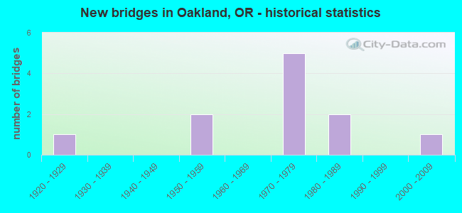
- New bridges - historical statistics
- 11920-1929
- 21950-1959
- 51970-1979
- 21980-1989
- 12000-2009


- Bridge Condition - Deck
- 25.0%Good
- 62.5%Satisfactory
- 12.5%Fair

- Bridge Condition - Superstructure
- 37.5%Good
- 50.0%Satisfactory
- 12.5%Serious

- Bridge Condition - Substructure
- 12.5%Good
- 62.5%Satisfactory
- 12.5%Fair
- 12.5%Poor

- Bridge Condition - Channel
- 60.0%Satisfactory
- 20.0%Fair
- 20.0%Poor
Find on map >> Show street view
Structure Number: 7508A234 0001, Location: 01.0 MI S OAKLAND WC LMTS (Lat: 43.436397, Lng: -123.313722), Route carried "on" structure: State highway 99, Year Built: 1976, Status: Open, Structure Length: 10.42m (34.19ft), Average Daily Traffic: 418 (year 2020), Truck Traffic: 38%, Average Future Daily Traffic: 560 (year 2030), Design Load: HS 20, Features Intersected: I-5 (HWY 001)
Minimum Vertical Clearance: 30+ m (98+ ft), Kilometerpoint: 226.580, Lanes on structure: 1, Lanes under structure: 4, Owner: State Highway Agency, Approaching Roadway Width: 7.9m (25.9ft), Material/Design: Concrete continuous, Design/Construction: Box Beam or Girders - Multiple, Number Of Spans In Main Unit: 4, Length of Maximum Span: 21.6m (70.9ft), Curb-To-Curb Width: 7.9m (25.9ft), Out-to-Out Width: 9.0m (29.5ft)
Condition: Deck: Satisfactory, Superstructure: Satisfactory, Substructure: Satisfactory, Operating Rating: 32.4 metric tons, Method Used To Determine Operating Rating: Load and Resistance Factor Rating (LRFR) rating reported by rating factor(RF) method using HL-93 loadings, Inventory Rating: 24.9 metric tons, Method Used To Determine Inventory Rating: Load and Resistance Factor Rating (LRFR) rating reported by rating factor(RF) method using HL-93 loadings, Structural Evaluation: Equal to present minimum criteria, Deck Geometry: Somewhat better than minimum adequacy, Underclear: High priority of corrective action, Approach Roadway Alignment: Equal to present desirable criteria, Length Of Structure Improvement: 6.20m (20.34ft), Designated Inspection Frequency: Every 24 months, Inspection Date: Febuary 2021, Bridge Improvement Cost: $591,000, Roadway Improvement Cost: $59,000, Total Project Cost: $946,000, Deck Structure Type: Concrete Cast-file-Place, Wearing Surface/Protective System: Wearing Surface: Monolithic Concrete
Find on map >> Show street view
Structure Number: 7549 001C14218, Location: 05.2MI N OF SUTHERLIN NCL (Lat: 43.460900, Lng: -123.321642), Route carried "on" structure: County highway , Year Built: 1953, Status: Open, Structure Length: 5.36m (17.59ft), Average Daily Traffic: 599 (year 2020), Truck Traffic: 10%, Average Future Daily Traffic: 712 (year 2030), Design Load: HS 20, Features Intersected: I-5 (HWY 001)@ METZ HILL, Facility Carried by Structure: METZ HILL ROAD
Minimum Vertical Clearance: 30+ m (98+ ft), Kilometerpoint: 228.817, Lanes on structure: 2, Lanes under structure: 4, Owner: State Highway Agency, Approaching Roadway Width: 7.9m (25.9ft), Skew: 1 degrees, Material/Design: Concrete continuous, Design/Construction: Tee Beam, Number Of Spans In Main Unit: 4, Length of Maximum Span: 14.9m (48.9ft), Curb-To-Curb Width: 7.9m (25.9ft), Out-to-Out Width: 9.3m (30.5ft)
Condition: Deck: Satisfactory, Superstructure: Satisfactory, Substructure: Satisfactory, Operating Rating: 50.8 metric tons, Method Used To Determine Operating Rating: Load Factor (LF), Inventory Rating: 29.9 metric tons, Method Used To Determine Inventory Rating: Load Factor (LF), Structural Evaluation: Equal to present minimum criteria, Deck Geometry: Somewhat better than minimum adequacy, Underclear: High priority of corrective action, Approach Roadway Alignment: Equal to present desirable criteria, Length Of Structure Improvement: 5.40m (17.72ft), Designated Inspection Frequency: Every 24 months, Inspection Date: Febuary 2021, Bridge Improvement Cost: $564,000, Roadway Improvement Cost: $56,000, Total Project Cost: $902,000, Deck Structure Type: Concrete Cast-file-Place, Wearing Surface/Protective System: Wearing Surface: Epoxy Overlay
Find on map >> Show street view
Structure Number: 7562A001 13911, Location: 03.2 MI N OF SUTHERLIN NC (Lat: 43.421156, Lng: -123.321433), Route carried "on" structure: County highway , Year Built: 1979, Status: Open, Structure Length: 5.82m (19.09ft), Average Daily Traffic: 21,625 (year 2020), Truck Traffic: 38%, Average Future Daily Traffic: 25,800 (year 2040), Design Load: HS 20, Features Intersected: I-5(HWY 001)@ GREEN VLLY, Facility Carried by Structure: GREEN VALLEY ROAD
Minimum Vertical Clearance: 30+ m (98+ ft), Kilometerpoint: 223.844, Lanes on structure: 2, Lanes under structure: 4, Owner: State Highway Agency, Approaching Roadway Width: 9.8m (32.2ft), Skew: 1 degrees, Material/Design: Prestressed concrete, Design/Construction: Stringer/Multi-beam, Number Of Spans In Main Unit: 2, Length of Maximum Span: 30.2m (99.1ft), Curb-To-Curb Width: 9.8m (32.2ft), Out-to-Out Width: 10.6m (34.8ft)
Condition: Deck: Satisfactory, Superstructure: Satisfactory, Substructure: Satisfactory, Operating Rating: 31.4 metric tons, Method Used To Determine Operating Rating: Load and Resistance Factor Rating (LRFR) rating reported by rating factor(RF) method using HL-93 loadings, Inventory Rating: 24.3 metric tons, Method Used To Determine Inventory Rating: Load and Resistance Factor Rating (LRFR) rating reported by rating factor(RF) method using HL-93 loadings, Structural Evaluation: Equal to present minimum criteria, Deck Geometry: Meets minimum limits, Underclear: High priority of corrective action, Approach Roadway Alignment: Equal to present desirable criteria, Length Of Structure Improvement: 5.80m (19.03ft), Designated Inspection Frequency: Every 24 months, Inspection Date: Febuary 2021, Bridge Improvement Cost: $692,000, Roadway Improvement Cost: $69,000, Total Project Cost: $1,107,000, Deck Structure Type: Concrete Cast-file-Place, Wearing Surface/Protective System: Wearing Surface: Monolithic Concrete
Find on map >> Show street view
Structure Number: 19C110002900059, Location: 3.0 MI N OF OAKLAND (Lat: 43.467836, Lng: -123.315519), Route carried "on" structure: County highway C0029, Year Built: 1980, Status: Open, Structure Length: 2.62m (8.60ft), Average Daily Traffic: 514 (year 2020), Truck Traffic: 7%, Average Future Daily Traffic: 579 (year 2025), Design Load: H 20, Features Intersected: CABIN CREEK, Facility Carried by Structure: COUNTY RD 29
Minimum Vertical Clearance: 30+ m (98+ ft), Kilometerpoint: 0.950, Lanes on structure: 2, Owner: County Highway Agency, Approaching Roadway Width: 7.9m (25.9ft), Skew: 2 degrees, Material/Design: Steel, Design/Construction: Stringer/Multi-beam, Number Of Spans In Main Unit: 1, Number Of Approach Spans: 2, Length of Maximum Span: 14.9m (48.9ft), Curb-To-Curb Width: 8.5m (27.9ft), Out-to-Out Width: 9.1m (29.9ft)
Condition: Deck: Good, Superstructure: Good, Substructure: Satisfactory, Channel: Satisfactory, Operating Rating: 64.8 metric tons, Method Used To Determine Operating Rating: Load and Resistance Factor Rating (LRFR) rating reported by rating factor(RF) method using HL-93 loadings, Inventory Rating: 49.9 metric tons, Method Used To Determine Inventory Rating: Load and Resistance Factor Rating (LRFR) rating reported by rating factor(RF) method using HL-93 loadings, Structural Evaluation: Equal to present minimum criteria, Deck Geometry: Somewhat better than minimum adequacy, Waterway Adequacy: Better than present minimum criteria, Approach Roadway Alignment: Meets minimum limits, Designated Inspection Frequency: Every 24 months, Inspection Date: April 2021, Deck Structure Type: Concrete Cast-file-Place, Wearing Surface/Protective System: Wearing Surface: Bituminous
Find on map >> Show street view
Structure Number: 19C281015200011, Location: 1.0 MI N OF OAKLAND (Lat: 43.435050, Lng: -123.307300), Route carried "on" structure: County highway C0152, Year Built: 1978, Status: Open, Structure Length: 2.47m (8.10ft), Average Daily Traffic: 157 (year 2020), Truck Traffic: 3%, Average Future Daily Traffic: 177 (year 2025), Design Load: H 20, Features Intersected: CABIN CREEK, Facility Carried by Structure: TRUITT ROAD
Minimum Vertical Clearance: 30+ m (98+ ft), Kilometerpoint: 0.177, Lanes on structure: 2, Owner: County Highway Agency, Approaching Roadway Width: 7.6m (24.9ft), Material/Design: Steel, Design/Construction: Stringer/Multi-beam, Number Of Spans In Main Unit: 1, Number Of Approach Spans: 1, Length of Maximum Span: 14.9m (48.9ft), Curb-To-Curb Width: 8.0m (26.2ft), Out-to-Out Width: 8.5m (27.9ft)
Condition: Deck: Satisfactory, Superstructure: Satisfactory, Substructure: Fair, Channel: Fair, Operating Rating: 67.7 metric tons, Method Used To Determine Operating Rating: Load and Resistance Factor Rating (LRFR) rating reported by rating factor(RF) method using HL-93 loadings, Inventory Rating: 52.2 metric tons, Method Used To Determine Inventory Rating: Load and Resistance Factor Rating (LRFR) rating reported by rating factor(RF) method using HL-93 loadings, Structural Evaluation: Somewhat better than minimum adequacy, Deck Geometry: Somewhat better than minimum adequacy, Waterway Adequacy: Somewhat better than minimum adequacy, Approach Roadway Alignment: Equal to present minimum criteria, Designated Inspection Frequency: Every 24 months, Inspection Date: April 2021, Deck Structure Type: Concrete Cast-file-Place, Wearing Surface/Protective System: Wearing Surface: Bituminous
Find on map >> Show street view
Structure Number: 19C42229A 005, Location: AT METZ HILL EXIT #142 (Lat: 43.460000, Lng: -123.320850), Route carried "on" structure: Spur County highway C029A, Year Built: 1989, Status: Open, Structure Length: 1.83m (6.00ft), Average Daily Traffic: 15 (year 2020), Average Future Daily Traffic: 15 (year 2025), Design Load: HS 20, Features Intersected: CABIN CREEK, Facility Carried by Structure: COUNTY RD 29A
Minimum Vertical Clearance: 30+ m (98+ ft), Kilometerpoint: 0.080, Lanes on structure: 1, Owner: County Highway Agency, Approaching Roadway Width: 4.6m (15.1ft), Material/Design: Steel, Design/Construction: Stringer/Multi-beam, Number Of Spans In Main Unit: 1, Length of Maximum Span: 17.7m (58.1ft), Curb-To-Curb Width: 4.5m (14.8ft), Out-to-Out Width: 4.5m (14.8ft)
Condition: Deck: Good, Superstructure: Good, Substructure: Good, Channel: Satisfactory, Operating Rating: 41.7 metric tons, Method Used To Determine Operating Rating: Load Factor (LF), Inventory Rating: 25.4 metric tons, Method Used To Determine Inventory Rating: Load Factor (LF), Structural Evaluation: Equal to present minimum criteria, Deck Geometry: Equal to present minimum criteria, Waterway Adequacy: Equal to present minimum criteria, Approach Roadway Alignment: Meets minimum limits, Designated Inspection Frequency: Every 24 months, Inspection Date: April 2021, Deck Structure Type: Open Grating, Wearing Surface/Protective System: Wearing Surface: Other
Find on map >> Show street view
Structure Number: 19C519038800108, Location: AT N OAKLAND CITY LIMIT (Lat: 43.425539, Lng: -123.303061), Route carried "on" structure: County highway A411, Year Built: 1925, Status: Posted for load-capacity, Structure Length: 14.48m (47.51ft), Average Daily Traffic: 2,176 (year 2020), Truck Traffic: 7%, Average Future Daily Traffic: 2,461 (year 2025), Design Load: H 15, Features Intersected: CALAPOOYA CRK & UPRR, Facility Carried by Structure: SHADY HWY #388
Minimum Vertical Clearance: 30+ m (98+ ft), Kilometerpoint: 1.738, Lanes on structure: 1, Owner: County Highway Agency, Approaching Roadway Width: 7.3m (24.0ft), Material/Design: Steel, Design/Construction: Truss - Deck, Number Of Spans In Main Unit: 1, Number Of Approach Spans: 9, Length of Maximum Span: 30.5m (100.1ft), Curb-To-Curb Width: 5.9m (19.4ft), Out-to-Out Width: 6.9m (22.6ft)
Condition: Deck: Fair, Superstructure: Serious, Substructure: Poor, Channel: Poor, Operating Rating: 23.0 metric tons, Method Used To Determine Operating Rating: Load and Resistance Factor Rating (LRFR) rating reported by rating factor(RF) method using HL-93 loadings, Inventory Rating: 17.5 metric tons, Method Used To Determine Inventory Rating: Load and Resistance Factor Rating (LRFR) rating reported by rating factor(RF) method using HL-93 loadings, Structural Evaluation: High priority of corrective action, Deck Geometry: High priority of replacement, Underclear: Meets minimum limits, Waterway Adequacy: Equal to present desirable criteria, Approach Roadway Alignment: Equal to present minimum criteria, Length Of Structure Improvement: 14.50m (47.57ft), Designated Inspection Frequency: Every 12 months, Critical Feature Inspection Frequency: Every 24 months, Underwater Inspection Frequency: Every 24 months, Inspection Date: April 2021, Critical Feature Inspection Date: April 2021, Underwater Inspection Date: November 2021, Bridge Improvement Cost: $1,521,000, Roadway Improvement Cost: $152,000, Total Project Cost: $2,434,000, Deck Structure Type: Concrete Cast-file-Place
Find on map >> Show street view
Structure Number: 20239 001 13871, Location: 02.8MI N OF SUTHERLIN NCL (Lat: 43.416000, Lng: -123.325411), Route carried "on" structure: Interstate 5, Year Built: 2006, Status: Open, Structure Length: 8.53m (27.99ft), Average Daily Traffic: 21,625 (year 2020), Truck Traffic: 38%, Average Future Daily Traffic: 25,800 (year 2040), Design Load: HL 93, Features Intersected: CALAPOOYA CREEK
Minimum Vertical Clearance: 30+ m (98+ ft), Kilometerpoint: 223.232, Lanes on structure: 4, Base Highway Network: Yes, Owner: State Highway Agency, Approaching Roadway Width: 26.8m (87.9ft), Skew: 30 degrees, Material/Design: Prestressed concrete, Design/Construction: Stringer/Multi-beam, Number Of Spans In Main Unit: 3, Length of Maximum Span: 41.9m (137.5ft), Curb-To-Curb Width: 26.8m (87.9ft), Out-to-Out Width: 28.3m (92.8ft)
Condition: Deck: Satisfactory, Superstructure: Good, Substructure: Satisfactory, Channel: Satisfactory, Operating Rating: 76.2 metric tons, Method Used To Determine Operating Rating: Load Factor (LF), Inventory Rating: 45.4 metric tons, Method Used To Determine Inventory Rating: Load Factor (LF), Structural Evaluation: Equal to present minimum criteria, Deck Geometry: Superior to present desirable criteria, Waterway Adequacy: Equal to present desirable criteria, Approach Roadway Alignment: Equal to present desirable criteria, Designated Inspection Frequency: Every 24 months, Inspection Date: Febuary 2021, Deck Structure Type: Concrete Cast-file-Place, Wearing Surface/Protective System: Wearing Surface: Monolithic Concrete
Find on map >> Show street view
Structure Number: 7508A234 0001, Location: 01.0 MI S OAKLAND WC LMTS (Lat: 43.436397, Lng: -123.313722), Route carried "under" structure: Interstate 5, Year Built: 1976, Structure Length: 0. m, Average Daily Traffic: 22,343 (year 2020), Truck Traffic: 38%, Features Intersected: I-5 (HWY 001), Facility Carried by Structure: OR 99
Minimum Vertical Clearance: 7.01m (23.00ft), Kilometerpoint: 225.743, Lanes on structure: 1, Lanes under structure: 4, Material/Design: Concrete continuous, Design/Construction: Box Beam or Girders - Multiple, Length of Maximum Span: 21.6m (70.9ft)
Find on map >> Show street view
Structure Number: 7549 001C14218, Location: 05.2MI N OF SUTHERLIN NCL (Lat: 43.460900, Lng: -123.321642), Route carried "under" structure: Interstate 5, Year Built: 1953, Structure Length: 0. m, Average Daily Traffic: 22,078 (year 2020), Truck Traffic: 38%, Features Intersected: I-5 (HWY 001)@ METZ HILL, Facility Carried by Structure: METZ HILL ROAD
Minimum Vertical Clearance: 5.59m (18.34ft), Kilometerpoint: 228.817, Lanes on structure: 2, Lanes under structure: 4, Material/Design: Concrete continuous, Design/Construction: Tee Beam, Length of Maximum Span: 14.9m (48.9ft)
Find on map >> Show street view
Structure Number: 7562A001 13911, Location: 03.2 MI N OF SUTHERLIN NC (Lat: 43.421156, Lng: -123.321433), Route carried "under" structure: Interstate 5, Year Built: 1979, Structure Length: 0. m, Average Daily Traffic: 21,625 (year 2020), Truck Traffic: 38%, Features Intersected: I-5(HWY 001)@ GREEN VLLY, Facility Carried by Structure: GREEN VALLEY ROAD
Minimum Vertical Clearance: 5.56m (18.24ft), Kilometerpoint: 223.844, Lanes on structure: 2, Lanes under structure: 4, Material/Design: Prestressed concrete, Design/Construction: Stringer/Multi-beam, Length of Maximum Span: 30.2m (99.1ft)