Bridge Statistics for Oakleaf Plantation, Florida (FL)
Condition, Traffic, Stress, Structural Evaluation, Project Costs
- National Bridge Inventory (NBI) Statistics
- 18Number of bridges
- 161ft / 49.3mTotal length
- 235,401Total average daily traffic
- 11,046Total average daily truck traffic
- National Bridge Inventory (NBI) Registered Bridges for Oakleaf Plantation
- No street view available for this location
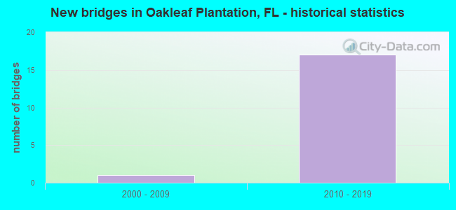
- New bridges - historical statistics
- 12000-2009
- 172010-2019
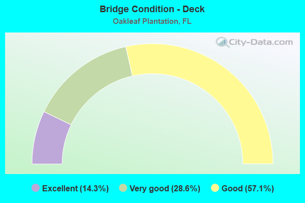
- Bridge Condition - Deck
- 14.3%Excellent
- 28.6%Very good
- 57.1%Good

- Bridge Condition - Superstructure
- 14.3%Excellent
- 14.3%Very good
- 71.4%Good
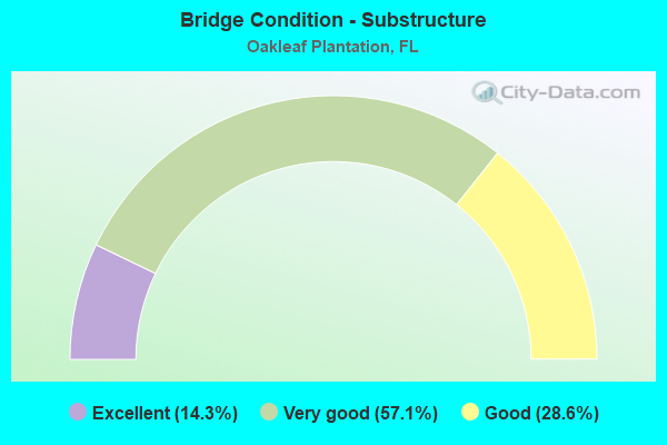
- Bridge Condition - Substructure
- 14.3%Excellent
- 57.1%Very good
- 28.6%Good
Find on map >> Show street view
Structure Number: 710082, Location: 2.0 M. S OF DUVAL CO LINE (Lat: 30.164533, Lng: -81.831281), Route carried "on" structure: State highway 23, Year Built: 2001, Year Reconstructed: 2017, Status: Open, Structure Length: 9.16m (30.05ft), Average Daily Traffic: 8,300 (year 2020), Truck Traffic: 5%, Average Future Daily Traffic: 14,400 (year 2042), Design Load: HL 93, Features Intersected: DOUBLE BRANCH
Minimum Vertical Clearance: 30+ m (98+ ft), Kilometerpoint: 7.223, Lanes on structure: 2, Base Highway Network: Yes, Toll: On toll road, Owner: State Toll Authority, Approaching Roadway Width: 10.4m (34.1ft), Material/Design: Prestressed concrete, Design/Construction: Stringer/Multi-beam, Number Of Spans In Main Unit: 4, Length of Maximum Span: 22.9m (75.1ft), Curb-To-Curb Width: 18.6m (61.0ft), Out-to-Out Width: 19.3m (63.3ft)
Condition: Deck: Good, Superstructure: Very good, Substructure: Very good, Channel: Satisfactory, Operating Rating: 56.2 metric tons, Method Used To Determine Operating Rating: Load and Resistance Factor (LRFR), Inventory Rating: 39.2 metric tons, Method Used To Determine Inventory Rating: Load and Resistance Factor (LRFR), Structural Evaluation: Equal to present desirable criteria, Deck Geometry: Superior to present desirable criteria, Waterway Adequacy: Superior to present desirable criteria, Approach Roadway Alignment: Equal to present desirable criteria, Designated Inspection Frequency: Every 24 months, Inspection Date: August 2020, Deck Structure Type: Concrete Cast-file-Place
Find on map >> Show street view
Structure Number: 710084, Location: 2.0 MI S OF DUVAL CO LINE (Lat: 30.164386, Lng: -81.830872), Route carried "on" structure: State highway 23, Year Built: 2017, Status: Open, Structure Length: 9.14m (29.99ft), Average Daily Traffic: 8,300 (year 2020), Truck Traffic: 5%, Average Future Daily Traffic: 14,400 (year 2042), Design Load: HL 93, Features Intersected: DOUBLE BRANCH
Minimum Vertical Clearance: 30+ m (98+ ft), Kilometerpoint: 7.208, Lanes on structure: 2, Owner: State Toll Authority, Approaching Roadway Width: 18.3m (60.0ft), Material/Design: Prestressed concrete, Design/Construction: Stringer/Multi-beam, Number Of Spans In Main Unit: 3, Length of Maximum Span: 30.5m (100.1ft), Curb-To-Curb Width: 20.5m (67.3ft), Out-to-Out Width: 20.5m (67.3ft)
Condition: Deck: Excellent, Superstructure: Excellent, Substructure: Excellent, Channel: Satisfactory, Operating Rating: 55.5 metric tons, Method Used To Determine Operating Rating: Load and Resistance Factor (LRFR), Inventory Rating: 40.8 metric tons, Method Used To Determine Inventory Rating: Load and Resistance Factor (LRFR), Structural Evaluation: Superior to present desirable criteria, Deck Geometry: Superior to present desirable criteria, Waterway Adequacy: Equal to present minimum criteria, Approach Roadway Alignment: Equal to present desirable criteria, Designated Inspection Frequency: Every 24 months, Inspection Date: August 2020, Deck Structure Type: Concrete Cast-file-Place
Find on map >> Show street view
Structure Number: 710085, Location: 1.3 MI S CLAY/DUVAL CO. L (Lat: 30.171853, Lng: -81.831375), Route carried "on" structure: County highway , Year Built: 2010, Status: Open, Structure Length: 7.45m (24.44ft), Average Daily Traffic: 9,001 (year 2020), Truck Traffic: 4%, Average Future Daily Traffic: 15,617 (year 2042), Design Load: HL 93, Features Intersected: SR-23 (BRANAN FIELD), Facility Carried by Structure: PLANTATION OAKS BL
Minimum Vertical Clearance: 30+ m (98+ ft), Kilometerpoint: 1.839, Lanes on structure: 2, Lanes under structure: 4, Owner: State Highway Agency, Approaching Roadway Width: 8.2m (26.9ft), Material/Design: Prestressed concrete, Design/Construction: Stringer/Multi-beam, Number Of Spans In Main Unit: 2, Length of Maximum Span: 36.6m (120.1ft), Curb or Sidewalk Widths: Left: 3.1m (10.2ft), Right: 1.9m (6.2ft), Curb-To-Curb Width: 8.2m (26.9ft), Out-to-Out Width: 14.1m (46.3ft)
Condition: Deck: Good, Superstructure: Good, Substructure: Very good, Operating Rating: 37.8 metric tons, Method Used To Determine Operating Rating: Load and Resistance Factor (LRFR), Inventory Rating: 33.9 metric tons, Method Used To Determine Inventory Rating: Load and Resistance Factor (LRFR), Structural Evaluation: Better than present minimum criteria, Deck Geometry: High priority of corrective action, Underclear: Superior to present desirable criteria, Approach Roadway Alignment: Equal to present desirable criteria, Designated Inspection Frequency: Every 24 months, Inspection Date: November 2020, Deck Structure Type: Concrete Cast-file-Place
Find on map >> Show street view
Structure Number: 710099, Location: 1.3 MI N OF OLD JENNG RD (Lat: 30.133119, Lng: -81.830483), Route carried "on" structure: State highway 23, Year Built: 2017, Status: Open, Structure Length: 5.48m (17.98ft), Average Daily Traffic: 5,600 (year 2020), Truck Traffic: 5%, Average Future Daily Traffic: 9,716 (year 2042), Design Load: HL 93, Features Intersected: TRAIL RIDGE ROAD
Minimum Vertical Clearance: 30+ m (98+ ft), Kilometerpoint: 3.756, Lanes on structure: 2, Lanes under structure: 6, Toll: On toll road, Owner: State Toll Authority, Approaching Roadway Width: 12.2m (40.0ft), Material/Design: Prestressed concrete, Design/Construction: Stringer/Multi-beam, Number Of Spans In Main Unit: 3, Length of Maximum Span: 25.9m (85.0ft), Curb-To-Curb Width: 12.2m (40.0ft), Out-to-Out Width: 13.1m (43.0ft)
Condition: Deck: Good, Superstructure: Good, Substructure: Good, Operating Rating: 44.5 metric tons, Method Used To Determine Operating Rating: Load and Resistance Factor (LRFR), Inventory Rating: 34.3 metric tons, Method Used To Determine Inventory Rating: Load and Resistance Factor (LRFR), Structural Evaluation: Better than present minimum criteria, Deck Geometry: Better than present minimum criteria, Underclear: Equal to present minimum criteria, Approach Roadway Alignment: Equal to present desirable criteria, Designated Inspection Frequency: Every 24 months, Inspection Date: March 2020, Deck Structure Type: Concrete Cast-file-Place
Find on map >> Show street view
Structure Number: 7101, Location: 1.3 MI N OF OLD JENNG RD (Lat: 30.133058, Lng: -81.830844), Route carried "on" structure: State highway 23, Year Built: 2018, Status: Open, Structure Length: 5.48m (17.98ft), Average Daily Traffic: 5,600 (year 2020), Truck Traffic: 5%, Average Future Daily Traffic: 9,716 (year 2042), Design Load: HL 93, Features Intersected: TRAIL RIDGE ROAD
Minimum Vertical Clearance: 30+ m (98+ ft), Kilometerpoint: 3.756, Lanes on structure: 2, Lanes under structure: 6, Toll: On toll road, Owner: State Toll Authority, Approaching Roadway Width: 12.2m (40.0ft), Material/Design: Prestressed concrete, Design/Construction: Stringer/Multi-beam, Number Of Spans In Main Unit: 3, Length of Maximum Span: 25.9m (85.0ft), Curb-To-Curb Width: 12.2m (40.0ft), Out-to-Out Width: 13.1m (43.0ft)
Condition: Deck: Good, Superstructure: Good, Substructure: Good, Operating Rating: 43.5 metric tons, Method Used To Determine Operating Rating: Load and Resistance Factor (LRFR), Inventory Rating: 33.0 metric tons, Method Used To Determine Inventory Rating: Load and Resistance Factor (LRFR), Structural Evaluation: Better than present minimum criteria, Deck Geometry: Better than present minimum criteria, Underclear: Equal to present minimum criteria, Approach Roadway Alignment: Equal to present desirable criteria, Designated Inspection Frequency: Every 24 months, Inspection Date: March 2020, Deck Structure Type: Concrete Cast-file-Place
Find on map >> Show street view
Structure Number: 710101, Location: 4.16 MI N OF SR 21 (Lat: 30.159556, Lng: -81.830781), Route carried "on" structure: State highway 23, Year Built: 2018, Status: Open, Structure Length: 6.29m (20.64ft), Average Daily Traffic: 5,600 (year 2020), Truck Traffic: 5%, Average Future Daily Traffic: 9,716 (year 2042), Design Load: HL 93, Features Intersected: OAKLEAF PLANTATION PKWY
Minimum Vertical Clearance: 30+ m (98+ ft), Kilometerpoint: 6.684, Lanes on structure: 2, Lanes under structure: 3, Toll: On toll road, Owner: State Toll Authority, Approaching Roadway Width: 13.4m (44.0ft), Material/Design: Prestressed concrete, Design/Construction: Stringer/Multi-beam, Number Of Spans In Main Unit: 2, Length of Maximum Span: 31.5m (103.3ft), Curb-To-Curb Width: 12.8m (42.0ft), Out-to-Out Width: 13.7m (44.9ft)
Condition: Deck: Very good, Superstructure: Good, Substructure: Very good, Operating Rating: 47.0 metric tons, Method Used To Determine Operating Rating: Load and Resistance Factor (LRFR), Inventory Rating: 36.3 metric tons, Method Used To Determine Inventory Rating: Load and Resistance Factor (LRFR), Structural Evaluation: Better than present minimum criteria, Deck Geometry: Equal to present desirable criteria, Underclear: Superior to present desirable criteria, Approach Roadway Alignment: Equal to present desirable criteria, Designated Inspection Frequency: Every 24 months, Inspection Date: June 2020, Deck Structure Type: Concrete Cast-file-Place
Find on map >> Show street view
Structure Number: 710102, Location: 4.16 MI N OF SR 21 (Lat: 30.159556, Lng: -81.831139), Route carried "on" structure: State highway 23, Year Built: 2018, Status: Open, Structure Length: 6.29m (20.64ft), Average Daily Traffic: 5,600 (year 2020), Truck Traffic: 5%, Average Future Daily Traffic: 9,716 (year 2042), Design Load: HL 93, Features Intersected: OAKLEAF PLANTATION PKWY
Minimum Vertical Clearance: 30+ m (98+ ft), Kilometerpoint: 6.684, Lanes on structure: 2, Lanes under structure: 2, Toll: On toll road, Owner: State Toll Authority, Approaching Roadway Width: 13.4m (44.0ft), Material/Design: Prestressed concrete, Design/Construction: Stringer/Multi-beam, Number Of Spans In Main Unit: 2, Length of Maximum Span: 31.5m (103.3ft), Curb-To-Curb Width: 12.8m (42.0ft), Out-to-Out Width: 13.7m (44.9ft)
Condition: Deck: Very good, Superstructure: Good, Substructure: Very good, Operating Rating: 47.4 metric tons, Method Used To Determine Operating Rating: Load and Resistance Factor (LRFR), Inventory Rating: 36.6 metric tons, Method Used To Determine Inventory Rating: Load and Resistance Factor (LRFR), Structural Evaluation: Better than present minimum criteria, Deck Geometry: Equal to present desirable criteria, Underclear: Superior to present desirable criteria, Approach Roadway Alignment: Equal to present desirable criteria, Designated Inspection Frequency: Every 24 months, Inspection Date: June 2020, Deck Structure Type: Concrete Cast-file-Place
Find on map >> Show street view
Structure Number: 710085, Location: 1.3 MI S CLAY/DUVAL CO. L (Lat: 30.171853, Lng: -81.831375), Route carried "under" structure: State highway , Year Built: 2010, Structure Length: 0. m, Average Daily Traffic: 23,000 (year 2018), Truck Traffic: 6%, Features Intersected: SR-23 (BRANAN FIELD), Facility Carried by Structure: PLANTATION OAKS BL
Minimum Vertical Clearance: 5.89m (19.32ft), Kilometerpoint: 1.680, Lanes on structure: 2, Lanes under structure: 4, Material/Design: Prestressed concrete, Design/Construction: Stringer/Multi-beam, Length of Maximum Span: 36.6m (120.1ft)
Find on map >> Show street view
Structure Number: 710099, Location: 1.3 MI N OF OLD JENNG RD (Lat: 30.133119, Lng: -81.830483), Route carried "under" structure: ServiceCounty highway , Year Built: 2017, Structure Length: 0. m, Average Daily Traffic: 15,500 (year 2016), Truck Traffic: 3%, Features Intersected: TRAIL RIDGE ROAD, Facility Carried by Structure: SR 23 NB 33.4
Minimum Vertical Clearance: 5.58m (18.31ft), Kilometerpoint: 0.000, Lanes on structure: 2, Lanes under structure: 1, Material/Design: Prestressed concrete, Design/Construction: Stringer/Multi-beam, Length of Maximum Span: 25.9m (85.0ft)
Find on map >> Show street view
Structure Number: 710099, Location: 1.3 MI N OF OLD JENNG RD (Lat: 30.133119, Lng: -81.830483), Route carried "under" structure: ServiceCounty highway , Year Built: 2017, Structure Length: 0. m, Average Daily Traffic: 15,500 (year 2016), Truck Traffic: 3%, Features Intersected: TRAIL RIDGE ROAD, Facility Carried by Structure: SR 23 NB 33.4
Minimum Vertical Clearance: 5.61m (18.41ft), Kilometerpoint: 0.000, Lanes on structure: 2, Lanes under structure: 1, Material/Design: Prestressed concrete, Design/Construction: Stringer/Multi-beam, Length of Maximum Span: 25.9m (85.0ft)
Find on map >> Show street view
Structure Number: 710099, Location: 1.3 MI N OF OLD JENNG RD (Lat: 30.133119, Lng: -81.830483), Route carried "under" structure: City street , Year Built: 2017, Structure Length: 0. m, Average Daily Traffic: 20,200 (year 2016), Truck Traffic: 9%, Features Intersected: TRAIL RIDGE ROAD, Facility Carried by Structure: SR 23 NB 33.4
Minimum Vertical Clearance: 5.79m (19.00ft), Kilometerpoint: 0.000, Lanes on structure: 2, Lanes under structure: 4, Material/Design: Prestressed concrete, Design/Construction: Stringer/Multi-beam, Length of Maximum Span: 25.9m (85.0ft)
Find on map >> Show street view
Structure Number: 7101, Location: 1.3 MI N OF OLD JENNG RD (Lat: 30.133058, Lng: -81.830844), Route carried "under" structure: City street , Year Built: 2018, Structure Length: 0. m, Average Daily Traffic: 20,200 (year 2016), Truck Traffic: 9%, Features Intersected: TRAIL RIDGE ROAD, Facility Carried by Structure: SR 23 SB 33.4
Minimum Vertical Clearance: 5.85m (19.19ft), Kilometerpoint: 0.000, Lanes on structure: 2, Lanes under structure: 4, Material/Design: Prestressed concrete, Design/Construction: Stringer/Multi-beam, Length of Maximum Span: 25.9m (85.0ft)
Find on map >> Show street view
Structure Number: 7101, Location: 1.3 MI N OF OLD JENNG RD (Lat: 30.133058, Lng: -81.830844), Route carried "under" structure: ServiceCounty highway , Year Built: 2018, Structure Length: 0. m, Average Daily Traffic: 15,500 (year 2016), Truck Traffic: 3%, Features Intersected: TRAIL RIDGE ROAD, Facility Carried by Structure: SR 23 SB 33.4
Minimum Vertical Clearance: 6.40m (21.00ft), Kilometerpoint: 0.000, Lanes on structure: 2, Lanes under structure: 1, Material/Design: Prestressed concrete, Design/Construction: Stringer/Multi-beam, Length of Maximum Span: 25.9m (85.0ft)
Find on map >> Show street view
Structure Number: 7101, Location: 1.3 MI N OF OLD JENNG RD (Lat: 30.133058, Lng: -81.830844), Route carried "under" structure: ServiceCounty highway , Year Built: 2018, Structure Length: 0. m, Average Daily Traffic: 15,500 (year 2016), Truck Traffic: 3%, Features Intersected: TRAIL RIDGE ROAD, Facility Carried by Structure: SR 23 SB 33.4
Minimum Vertical Clearance: 6.04m (19.82ft), Kilometerpoint: 0.000, Lanes on structure: 2, Lanes under structure: 1, Material/Design: Prestressed concrete, Design/Construction: Stringer/Multi-beam, Length of Maximum Span: 25.9m (85.0ft)
Find on map >> Show street view
Structure Number: 710101, Location: 4.16 MI N OF SR 21 (Lat: 30.159556, Lng: -81.830781), Route carried "under" structure: ServiceCity street , Year Built: 2018, Structure Length: 0. m, Average Daily Traffic: 15,500 (year 2016), Truck Traffic: 3%, Features Intersected: OAKLEAF PLANTATION PKWY, Facility Carried by Structure: SR 23 NB 35.3
Minimum Vertical Clearance: 5.84m (19.16ft), Kilometerpoint: 0.000, Lanes on structure: 2, Lanes under structure: 2, Material/Design: Prestressed concrete, Design/Construction: Stringer/Multi-beam, Length of Maximum Span: 31.5m (103.3ft)
Find on map >> Show street view
Structure Number: 710101, Location: 4.16 MI N OF SR 21 (Lat: 30.159556, Lng: -81.830781), Route carried "under" structure: ServiceCity street , Year Built: 2018, Structure Length: 0. m, Average Daily Traffic: 15,500 (year 2016), Truck Traffic: 3%, Features Intersected: OAKLEAF PLANTATION PKWY, Facility Carried by Structure: SR 23 NB 35.3
Minimum Vertical Clearance: 5.43m (17.81ft), Kilometerpoint: 0.000, Lanes on structure: 2, Lanes under structure: 1, Material/Design: Prestressed concrete, Design/Construction: Stringer/Multi-beam, Length of Maximum Span: 31.5m (103.3ft)
Find on map >> Show street view
Structure Number: 710102, Location: 4.16 MI N OF SR 21 (Lat: 30.159556, Lng: -81.831139), Route carried "under" structure: ServiceCity street , Year Built: 2018, Structure Length: 0. m, Average Daily Traffic: 15,500 (year 2016), Truck Traffic: 3%, Features Intersected: OAKLEAF PLANTATION PKWY, Facility Carried by Structure: SR 23 SB 35.3
Minimum Vertical Clearance: 5.51m (18.08ft), Kilometerpoint: 0.000, Lanes on structure: 2, Lanes under structure: 1, Material/Design: Prestressed concrete, Design/Construction: Stringer/Multi-beam, Length of Maximum Span: 31.5m (103.3ft)
Find on map >> Show street view
Structure Number: 710102, Location: 4.16 MI N OF SR 21 (Lat: 30.159556, Lng: -81.831139), Route carried "under" structure: ServiceCity street , Year Built: 2018, Structure Length: 0. m, Average Daily Traffic: 15,500 (year 2016), Truck Traffic: 3%, Features Intersected: OAKLEAF PLANTATION PKWY, Facility Carried by Structure: SR 23 SB 35.3
Minimum Vertical Clearance: 5.61m (18.41ft), Kilometerpoint: 0.000, Lanes on structure: 2, Lanes under structure: 1, Material/Design: Prestressed concrete, Design/Construction: Stringer/Multi-beam, Length of Maximum Span: 31.5m (103.3ft)