Bridge Statistics for Oakley, Kansas (KS)
Condition, Traffic, Stress, Structural Evaluation, Project Costs
- National Bridge Inventory (NBI) Statistics
- 21Number of bridges
- 246ft / 74.7mTotal length
- 78,463Total average daily traffic
- 24,043Total average daily truck traffic
- National Bridge Inventory (NBI) Registered Bridges for Oakley
- No street view available for this location
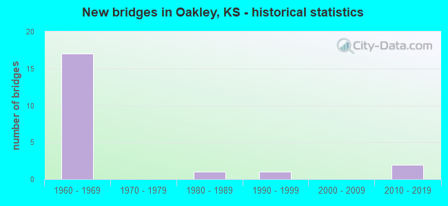
- New bridges - historical statistics
- 171960-1969
- 11980-1989
- 11990-1999
- 22010-2019
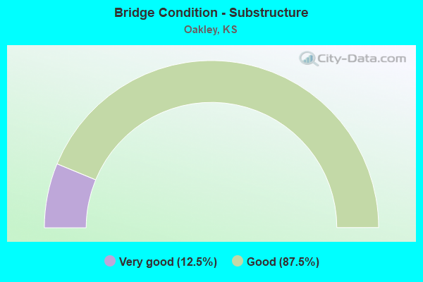
- Bridge Condition - Substructure
- 12.5%Very good
- 87.5%Good
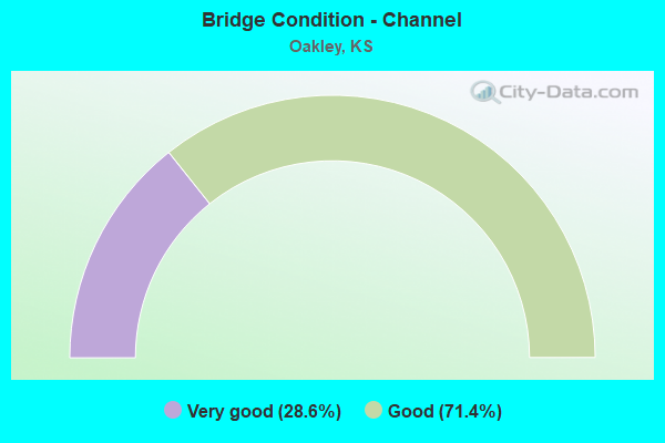
- Bridge Condition - Channel
- 28.6%Very good
- 71.4%Good
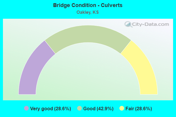
- Bridge Condition - Culverts
- 28.6%Very good
- 42.9%Good
- 28.6%Fair
Find on map >> Show street view
Structure Number: 550022, Location: 1.6S 4.0W OF OAKLEY (Lat: 39.103039, Lng: -100.923553), Route carried "on" structure: County highway 1594, Year Built: 1961, Status: Posted for load, Structure Length: 1.33m (4.36ft), Average Daily Traffic: 220 (year 2014), Truck Traffic: 20%, Average Future Daily Traffic: 230 (year 2040), Design Load: H 15, Features Intersected: NORTH BR. HACKBERRY CR.
Minimum Vertical Clearance: 30.47m (99.97ft), Kilometerpoint: 9.897, Lanes on structure: 2, Owner: County Highway Agency, Approaching Roadway Width: 7.3m (24.0ft), Material/Design: Concrete, Design/Construction: Culvert, Number Of Spans In Main Unit: 3, Length of Maximum Span: 4.3m (14.1ft), Curb or Sidewalk Widths: Left: 0.3m (1.0ft), Right: 0.3m (1.0ft), Curb-To-Curb Width: 8.5m (27.9ft), Out-to-Out Width: 9.1m (29.9ft)
Condition: Channel: Good, Culverts: Good, Operating Rating: 24.7 metric tons, Method Used To Determine Operating Rating: Load Factor (LF), Inventory Rating: 14.8 metric tons, Method Used To Determine Inventory Rating: Load Factor (LF), Structural Evaluation: Meets minimum limits, Deck Geometry: Equal to present minimum criteria, Waterway Adequacy: Equal to present desirable criteria, Approach Roadway Alignment: Equal to present desirable criteria, Bridge Posting: Required (Relationship of Operating Rating to Maximum Legal Load: 30.0 - 39.9% below), Designated Inspection Frequency: Every 24 months, Inspection Date: September 2020, Other Special Inspection Date: March 2021, Wearing Surface/Protective System: Wearing Surface: Gravel
Find on map >> Show street view
Structure Number: 97044700418, Location: 9.0S 8.0E OF MINGO (Lat: 39.147992, Lng: -100.814444), Route carried "on" structure: County highway 9707, Year Built: 1984, Status: Open, Structure Length: 1.33m (4.36ft), Average Daily Traffic: 30 (year 2014), Average Future Daily Traffic: 40 (year 2040), Design Load: H 20, Features Intersected: SOUTH FORK SALINE RIVER, Facility Carried by Structure: County Rd 32
Minimum Vertical Clearance: 30.47m (99.97ft), Kilometerpoint: 0.000, Lanes on structure: 2, Owner: County Highway Agency, Approaching Roadway Width: 8.5m (27.9ft), Material/Design: Concrete, Design/Construction: Culvert, Number Of Spans In Main Unit: 3, Length of Maximum Span: 4.3m (14.1ft), Curb-To-Curb Width: 8.5m (27.9ft), Out-to-Out Width: 9.1m (29.9ft)
Condition: Channel: Good, Culverts: Good, Operating Rating: 36.5 metric tons, Method Used To Determine Operating Rating: Load Factor (LF), Inventory Rating: 21.8 metric tons, Method Used To Determine Inventory Rating: Load Factor (LF), Structural Evaluation: Equal to present minimum criteria, Deck Geometry: Better than present minimum criteria, Waterway Adequacy: Better than present minimum criteria, Approach Roadway Alignment: Equal to present desirable criteria, Designated Inspection Frequency: Every 24 months, Inspection Date: June 2020, Other Special Inspection Date: March 2021, Wearing Surface/Protective System: Wearing Surface: Gravel
Find on map >> Show street view
Structure Number: 999907000320011, Location: JCT US40/I70, WB (Lat: 39.119444, Lng: -100.807778), Route carried "on" structure: Interstate 70, Year Built: 1965, Status: Open, Structure Length: 6.13m (20.11ft), Average Daily Traffic: 5,456 (year 2020), Truck Traffic: 37%, Average Future Daily Traffic: 7,795 (year 2041), Design Load: HS 20+Mod, Features Intersected: RS1977 LT, US40 HWY RT
Minimum Vertical Clearance: 30.47m (99.97ft), Kilometerpoint: 0.616, Lanes on structure: 2, Lanes under structure: 4, Base Highway Network: Yes, Owner: State Highway Agency, Approaching Roadway Width: 12.2m (40.0ft), Skew: 3 degrees, Material/Design: Concrete continuous, Design/Construction: Slab, Number Of Spans In Main Unit: 4, Length of Maximum Span: 17.4m (57.1ft), Curb-To-Curb Width: 12.2m (40.0ft), Out-to-Out Width: 12.6m (41.3ft)
Condition: Deck: Good, Superstructure: Good, Substructure: Good, Operating Rating: 60.8 metric tons, Method Used To Determine Operating Rating: Load Factor (LF), Inventory Rating: 36.3 metric tons, Method Used To Determine Inventory Rating: Load Factor (LF), Structural Evaluation: Better than present minimum criteria, Deck Geometry: Better than present minimum criteria, Underclear: Equal to present minimum criteria, Approach Roadway Alignment: Equal to present desirable criteria, Length Of Structure Improvement: 20.11m (65.98ft), Designated Inspection Frequency: Every 24 months, Inspection Date: June 2020, Deck Structure Type: Concrete Cast-file-Place, Wearing Surface/Protective System: Wearing Surface: Epoxy Overlay
Find on map >> Show street view
Structure Number: 999907000320021, Location: JCT US40/I70, EB (Lat: 39.119444, Lng: -100.808056), Route carried "on" structure: Interstate 70, Year Built: 1965, Status: Open, Structure Length: 6.13m (20.11ft), Average Daily Traffic: 5,456 (year 2020), Truck Traffic: 37%, Average Future Daily Traffic: 7,795 (year 2041), Design Load: HS 20+Mod, Features Intersected: RS1977 LT, US40 HWY RT
Minimum Vertical Clearance: 30.47m (99.97ft), Kilometerpoint: 0.562, Lanes on structure: 2, Lanes under structure: 4, Base Highway Network: Yes, Owner: State Highway Agency, Approaching Roadway Width: 12.2m (40.0ft), Skew: 3 degrees, Material/Design: Concrete continuous, Design/Construction: Slab, Number Of Spans In Main Unit: 4, Length of Maximum Span: 17.4m (57.1ft), Curb-To-Curb Width: 12.2m (40.0ft), Out-to-Out Width: 12.6m (41.3ft)
Condition: Deck: Good, Superstructure: Good, Substructure: Good, Operating Rating: 60.8 metric tons, Method Used To Determine Operating Rating: Load Factor (LF), Inventory Rating: 36.3 metric tons, Method Used To Determine Inventory Rating: Load Factor (LF), Structural Evaluation: Better than present minimum criteria, Deck Geometry: Better than present minimum criteria, Underclear: Equal to present minimum criteria, Approach Roadway Alignment: Equal to present desirable criteria, Length Of Structure Improvement: 20.11m (65.98ft), Designated Inspection Frequency: Every 24 months, Inspection Date: June 2020, Deck Structure Type: Concrete Cast-file-Place, Wearing Surface/Protective System: Wearing Surface: Epoxy Overlay
Find on map >> Show street view
Structure Number: 999907000320031, Location: 2.31MI E LOGAN CO LINE (Lat: 39.112222, Lng: -100.775556), Route carried "on" structure: ServiceCounty highway 9, Year Built: 1964, Status: Open, Structure Length: 7.33m (24.05ft), Average Daily Traffic: 21 (year 2020), Average Future Daily Traffic: 9,644 (year 2041), Design Load: H 15, Features Intersected: I70 HWY, Facility Carried by Structure: LOCAL ROAD
Minimum Vertical Clearance: 30.47m (99.97ft), Kilometerpoint: 2.354, Lanes on structure: 2, Lanes under structure: 4, Owner: State Highway Agency, Approaching Roadway Width: 7.3m (24.0ft), Material/Design: Concrete continuous, Design/Construction: Box Beam or Girders - Multiple, Number Of Spans In Main Unit: 4, Length of Maximum Span: 20.7m (67.9ft), Curb-To-Curb Width: 7.6m (24.9ft), Out-to-Out Width: 9.0m (29.5ft)
Condition: Deck: Good, Superstructure: Good, Substructure: Good, Operating Rating: 66.0 metric tons, Method Used To Determine Operating Rating: Load Factor (LF), Inventory Rating: 39.6 metric tons, Method Used To Determine Inventory Rating: Load Factor (LF), Structural Evaluation: Better than present minimum criteria, Deck Geometry: Equal to present minimum criteria, Underclear: Somewhat better than minimum adequacy, Approach Roadway Alignment: Somewhat better than minimum adequacy, Length Of Structure Improvement: 24.05m (78.90ft), Designated Inspection Frequency: Every 24 months, Inspection Date: June 2020, Deck Structure Type: Concrete Cast-file-Place, Wearing Surface/Protective System: Wearing Surface: Monolithic Concrete
Find on map >> Show street view
Structure Number: 999907000550011, Location: S THOMAS CO LINE (Lat: 39.133333, Lng: -100.820556), Route carried "on" structure: County highway 5508, Year Built: 1965, Status: Open, Structure Length: 9.10m (29.86ft), Average Daily Traffic: 127 (year 2020), Truck Traffic: 2%, Average Future Daily Traffic: 7,144 (year 2041), Design Load: H 15, Features Intersected: I70 HWY, WL-EL, Facility Carried by Structure: LOCAL ROAD
Minimum Vertical Clearance: 30.47m (99.97ft), Kilometerpoint: 0.850, Lanes on structure: 2, Lanes under structure: 4, Owner: State Highway Agency, Approaching Roadway Width: 7.3m (24.0ft), Material/Design: Concrete continuous, Design/Construction: Box Beam or Girders - Multiple, Number Of Spans In Main Unit: 4, Length of Maximum Span: 25.6m (84.0ft), Curb-To-Curb Width: 7.6m (24.9ft), Out-to-Out Width: 9.0m (29.5ft)
Condition: Deck: Good, Superstructure: Good, Substructure: Good, Operating Rating: 52.3 metric tons, Method Used To Determine Operating Rating: Load Factor (LF), Inventory Rating: 31.3 metric tons, Method Used To Determine Inventory Rating: Load Factor (LF), Structural Evaluation: Better than present minimum criteria, Deck Geometry: Somewhat better than minimum adequacy, Underclear: Somewhat better than minimum adequacy, Approach Roadway Alignment: Somewhat better than minimum adequacy, Length Of Structure Improvement: 29.85m (97.93ft), Designated Inspection Frequency: Every 24 months, Inspection Date: June 2020, Deck Structure Type: Concrete Cast-file-Place, Wearing Surface/Protective System: Wearing Surface: Monolithic Concrete
Find on map >> Show street view
Structure Number: 999907000550021, Location: 0.81MI SE THOMAS COLN, WB (Lat: 39.123611, Lng: -100.811667), Route carried "on" structure: Interstate 70, Year Built: 1965, Status: Open, Structure Length: 5.60m (18.37ft), Average Daily Traffic: 5,456 (year 2020), Truck Traffic: 37%, Average Future Daily Traffic: 7,795 (year 2041), Design Load: HS 20+Mod, Features Intersected: UP RAILROAD
Minimum Vertical Clearance: 30.47m (99.97ft), Kilometerpoint: 0.027, Lanes on structure: 2, Base Highway Network: Yes, Owner: State Highway Agency, Approaching Roadway Width: 12.2m (40.0ft), Skew: 3 degrees, Material/Design: Concrete continuous, Design/Construction: Slab, Number Of Spans In Main Unit: 5, Length of Maximum Span: 12.3m (40.4ft), Curb-To-Curb Width: 12.2m (40.0ft), Out-to-Out Width: 12.8m (42.0ft)
Condition: Deck: Good, Superstructure: Good, Substructure: Good, Operating Rating: 49.9 metric tons, Method Used To Determine Operating Rating: Load Factor (LF), Inventory Rating: 29.9 metric tons, Method Used To Determine Inventory Rating: Load Factor (LF), Structural Evaluation: Better than present minimum criteria, Deck Geometry: Better than present minimum criteria, Underclear: Somewhat better than minimum adequacy, Approach Roadway Alignment: Equal to present desirable criteria, Length Of Structure Improvement: 18.36m (60.24ft), Designated Inspection Frequency: Every 24 months, Inspection Date: June 2020, Deck Structure Type: Concrete Cast-file-Place, Wearing Surface/Protective System: Wearing Surface: Epoxy Overlay
Find on map >> Show street view
Structure Number: 999907000550031, Location: 0.80MI SE THOMAS COLN, EB (Lat: 39.123611, Lng: -100.811944), Route carried "on" structure: Interstate 70, Year Built: 1965, Status: Open, Structure Length: 5.60m (18.37ft), Average Daily Traffic: 5,456 (year 2020), Truck Traffic: 37%, Average Future Daily Traffic: 7,795 (year 2041), Design Load: HS 20+Mod, Features Intersected: UP RAILROAD
Minimum Vertical Clearance: 30.47m (99.97ft), Kilometerpoint: 1.289, Lanes on structure: 2, Base Highway Network: Yes, Owner: State Highway Agency, Approaching Roadway Width: 12.2m (40.0ft), Skew: 3 degrees, Material/Design: Concrete continuous, Design/Construction: Slab, Number Of Spans In Main Unit: 5, Length of Maximum Span: 12.3m (40.4ft), Curb-To-Curb Width: 12.2m (40.0ft), Out-to-Out Width: 12.8m (42.0ft)
Condition: Deck: Good, Superstructure: Good, Substructure: Good, Operating Rating: 49.9 metric tons, Method Used To Determine Operating Rating: Load Factor (LF), Inventory Rating: 29.9 metric tons, Method Used To Determine Inventory Rating: Load Factor (LF), Structural Evaluation: Better than present minimum criteria, Deck Geometry: Better than present minimum criteria, Underclear: Somewhat better than minimum adequacy, Approach Roadway Alignment: Equal to present desirable criteria, Length Of Structure Improvement: 18.36m (60.24ft), Designated Inspection Frequency: Every 24 months, Inspection Date: June 2020, Deck Structure Type: Concrete Cast-file-Place, Wearing Surface/Protective System: Wearing Surface: Epoxy Overlay
Find on map >> Show street view
Structure Number: 999907000970301, Location: 0.50MI SE JT U83 (Lat: 39.183611, Lng: -100.863611), Route carried "on" structure: Interstate 70, Year Built: 1965, Status: Open, Structure Length: 2.51m (8.23ft), Average Daily Traffic: 5,456 (year 2020), Truck Traffic: 37%, Average Future Daily Traffic: 7,795 (year 2041), Design Load: HS 20+Mod, Features Intersected: N FORK SALINE RIVER
Minimum Vertical Clearance: 30.47m (99.97ft), Kilometerpoint: 56.898, Lanes on structure: 4, Base Highway Network: Yes, Owner: State Highway Agency, Approaching Roadway Width: 12.2m (40.0ft), Skew: 20 degrees, Material/Design: Concrete, Design/Construction: Culvert, Number Of Spans In Main Unit: 4, Length of Maximum Span: 6.1m (20.0ft), Curb-To-Curb Width: 24.4m (80.1ft), Out-to-Out Width: 39.5m (129.6ft)
Condition: Channel: Good, Culverts: Fair, Operating Rating: 17.2 metric tons, Method Used To Determine Operating Rating: Load Factor (LF), Inventory Rating: 10.0 metric tons, Method Used To Determine Inventory Rating: Load Factor (LF), Structural Evaluation: High priority of corrective action, Deck Geometry: Superior to present desirable criteria, Waterway Adequacy: Better than present minimum criteria, Approach Roadway Alignment: Equal to present desirable criteria, Bridge Posting: Required (Relationship of Operating Rating to Maximum Legal Load: 10.0 - 19.9% below), Length Of Structure Improvement: 8.25m (27.07ft), Designated Inspection Frequency: Every 24 months, Inspection Date: June 2020, Deck Structure Type: Concrete Cast-file-Place, Wearing Surface/Protective System: Wearing Surface: Bituminous
Find on map >> Show street view
Structure Number: 999907000970311, Location: 2.29 MI SE US83 (Lat: 39.162222, Lng: -100.845000), Route carried "on" structure: ServiceCounty highway 119, Year Built: 1965, Status: Open, Structure Length: 8.85m (29.04ft), Average Daily Traffic: 10 (year 2020), Average Future Daily Traffic: 7,144 (year 2041), Design Load: H 15, Features Intersected: I70 HWY, WL-EL, Facility Carried by Structure: LOCAL ROAD
Minimum Vertical Clearance: 30.47m (99.97ft), Kilometerpoint: 4.249, Lanes on structure: 2, Lanes under structure: 4, Owner: State Highway Agency, Approaching Roadway Width: 7.3m (24.0ft), Material/Design: Concrete continuous, Design/Construction: Box Beam or Girders - Multiple, Number Of Spans In Main Unit: 4, Length of Maximum Span: 24.4m (80.1ft), Curb-To-Curb Width: 7.6m (24.9ft), Out-to-Out Width: 9.0m (29.5ft)
Condition: Deck: Good, Superstructure: Good, Substructure: Very good, Operating Rating: 51.3 metric tons, Method Used To Determine Operating Rating: Load Factor (LF), Inventory Rating: 30.8 metric tons, Method Used To Determine Inventory Rating: Load Factor (LF), Structural Evaluation: Better than present minimum criteria, Deck Geometry: Equal to present minimum criteria, Underclear: Meets minimum limits, Approach Roadway Alignment: Somewhat better than minimum adequacy, Length Of Structure Improvement: 29.05m (95.31ft), Designated Inspection Frequency: Every 24 months, Inspection Date: June 2020, Deck Structure Type: Concrete Cast-file-Place, Wearing Surface/Protective System: Wearing Surface: Monolithic Concrete
Find on map >> Show street view
Structure Number: 999907000970321, Location: 3.74 MI SE US83 (Lat: 39.144444, Lng: -100.830556), Route carried "on" structure: Interstate 70, Year Built: 1965, Status: Open, Structure Length: 4.41m (14.47ft), Average Daily Traffic: 5,456 (year 2020), Truck Traffic: 37%, Average Future Daily Traffic: 7,795 (year 2041), Design Load: H 20, Features Intersected: S FORK SALINE RIVER
Minimum Vertical Clearance: 30.47m (99.97ft), Kilometerpoint: 62.138, Lanes on structure: 4, Lanes under structure: 2, Base Highway Network: Yes, Owner: State Highway Agency, Approaching Roadway Width: 12.2m (40.0ft), Skew: 20 degrees, Material/Design: Concrete, Design/Construction: Culvert, Number Of Spans In Main Unit: 7, Length of Maximum Span: 6.1m (20.0ft), Curb-To-Curb Width: 24.4m (80.1ft), Out-to-Out Width: 39.5m (129.6ft)
Condition: Channel: Good, Culverts: Fair, Operating Rating: 62.6 metric tons, Method Used To Determine Operating Rating: Load Factor (LF), Inventory Rating: 38.1 metric tons, Method Used To Determine Inventory Rating: Load Factor (LF), Structural Evaluation: Somewhat better than minimum adequacy, Deck Geometry: Superior to present desirable criteria, Underclear: High priority of corrective action, Waterway Adequacy: Equal to present desirable criteria, Approach Roadway Alignment: Equal to present desirable criteria, Bridge Posting: Required (Relationship of Operating Rating to Maximum Legal Load: 10.0 - 19.9% below), Length Of Structure Improvement: 14.47m (47.47ft), Designated Inspection Frequency: Every 24 months, Inspection Date: June 2020, Deck Structure Type: Concrete Cast-file-Place, Wearing Surface/Protective System: Wearing Surface: Bituminous
Find on map >> Show street view
Structure Number: 999908300550291, Location: 2.03 MI N OF RS1672 (Lat: 39.075833, Lng: -100.850000), Route carried "on" structure: US 83, Year Built: 1998, Status: Open, Structure Length: 0.80m (2.62ft), Average Daily Traffic: 3,455 (year 2020), Truck Traffic: 30%, Average Future Daily Traffic: 5,236 (year 2041), Design Load: HS 20, Features Intersected: HACKBERRY CR N BR
Minimum Vertical Clearance: 30.47m (99.97ft), Kilometerpoint: 42.070, Lanes on structure: 2, Base Highway Network: Yes, Owner: State Highway Agency, Approaching Roadway Width: 12.2m (40.0ft), Material/Design: Concrete, Design/Construction: Culvert, Number Of Spans In Main Unit: 2, Length of Maximum Span: 3.7m (12.1ft), Curb-To-Curb Width: 12.2m (40.0ft), Out-to-Out Width: 26.4m (86.6ft)
Condition: Channel: Good, Culverts: Good, Inventory Rating: 12.2 metric tons, Method Used To Determine Inventory Rating: Load Factor (LF), Structural Evaluation: High priority of corrective action, Deck Geometry: Equal to present minimum criteria, Waterway Adequacy: Equal to present desirable criteria, Approach Roadway Alignment: Equal to present desirable criteria, Length Of Structure Improvement: 2.63m (8.63ft), Designated Inspection Frequency: Every 24 months, Inspection Date: June 2020, Wearing Surface/Protective System: Wearing Surface: Bituminous
Find on map >> Show street view
Structure Number: 999908300970381, Location: JT I70/US83 (Lat: 39.189167, Lng: -100.869722), Route carried "on" structure: US 83, Year Built: 1965, Status: Open, Structure Length: 11.29m (37.04ft), Average Daily Traffic: 4,220 (year 2020), Truck Traffic: 19%, Average Future Daily Traffic: 6,029 (year 2041), Design Load: HS 20, Features Intersected: I70 HWY
Minimum Vertical Clearance: 30.47m (99.97ft), Kilometerpoint: 6.233, Lanes on structure: 2, Lanes under structure: 4, Base Highway Network: Yes, Owner: State Highway Agency, Approaching Roadway Width: 13.4m (44.0ft), Material/Design: Concrete continuous, Design/Construction: Box Beam or Girders - Multiple, Number Of Spans In Main Unit: 4, Length of Maximum Span: 31.7m (104.0ft), Curb-To-Curb Width: 8.5m (27.9ft), Out-to-Out Width: 9.9m (32.5ft)
Condition: Deck: Good, Superstructure: Good, Substructure: Good, Operating Rating: 71.8 metric tons, Method Used To Determine Operating Rating: Load Factor (LF), Inventory Rating: 43.0 metric tons, Method Used To Determine Inventory Rating: Load Factor (LF), Structural Evaluation: Better than present minimum criteria, Deck Geometry: Meets minimum limits, Underclear: Meets minimum limits, Approach Roadway Alignment: Meets minimum limits, Length Of Structure Improvement: 37.05m (121.56ft), Designated Inspection Frequency: Every 24 months, Inspection Date: June 2020, Deck Structure Type: Concrete Cast-file-Place, Wearing Surface/Protective System: Wearing Surface: Low Slump Concrete
Find on map >> Show street view
Structure Number: 999908300970561, Location: 1.05 MI N LOGAN CO LINE (Lat: 39.148889, Lng: -100.868889), Route carried "on" structure: US 83, Year Built: 2016, Status: Open, Structure Length: 2.24m (7.35ft), Average Daily Traffic: 4,220 (year 2020), Truck Traffic: 19%, Average Future Daily Traffic: 6,029 (year 2041), Design Load: HL 93, Features Intersected: S FORK SALINE RIVER
Minimum Vertical Clearance: 30.47m (99.97ft), Kilometerpoint: 1.761, Lanes on structure: 2, Base Highway Network: Yes, Owner: State Highway Agency, Approaching Roadway Width: 13.4m (44.0ft), Material/Design: Concrete, Design/Construction: Culvert, Number Of Spans In Main Unit: 5, Length of Maximum Span: 4.3m (14.1ft), Curb-To-Curb Width: 13.4m (44.0ft), Out-to-Out Width: 23.2m (76.1ft)
Condition: Channel: Very good, Culverts: Very good, Operating Rating: 75.2 metric tons, Method Used To Determine Operating Rating: Load and Resistance Factor Rating (LRFR) rating reported by rating factor(RF) method using HL-93 loadings, Inventory Rating: 58.0 metric tons, Method Used To Determine Inventory Rating: Load and Resistance Factor Rating (LRFR) rating reported by rating factor(RF) method using HL-93 loadings, Structural Evaluation: Equal to present desirable criteria, Deck Geometry: Better than present minimum criteria, Waterway Adequacy: Equal to present desirable criteria, Approach Roadway Alignment: Equal to present desirable criteria, Length Of Structure Improvement: 7.33m (24.05ft), Designated Inspection Frequency: Every 24 months, Inspection Date: June 2020, Wearing Surface/Protective System: Wearing Surface: Bituminous, Deck Protection: Epoxy Coated Reinforcing
Find on map >> Show street view
Structure Number: 999908300970571, Location: 3.56MI N LOGAN CO LINE (Lat: 39.183333, Lng: -100.869722), Route carried "on" structure: US 83, Year Built: 2016, Status: Open, Structure Length: 2.03m (6.66ft), Average Daily Traffic: 4,220 (year 2020), Truck Traffic: 19%, Average Future Daily Traffic: 6,029 (year 2041), Design Load: HL 93, Features Intersected: N FORK SALINE RIVER
Minimum Vertical Clearance: 30.47m (99.97ft), Kilometerpoint: 5.607, Lanes on structure: 2, Base Highway Network: Yes, Owner: State Highway Agency, Approaching Roadway Width: 13.4m (44.0ft), Material/Design: Concrete, Design/Construction: Culvert, Number Of Spans In Main Unit: 4, Length of Maximum Span: 4.9m (16.1ft), Curb-To-Curb Width: 13.4m (44.0ft), Out-to-Out Width: 21.2m (69.6ft)
Condition: Channel: Very good, Culverts: Very good, Operating Rating: 95.3 metric tons, Method Used To Determine Operating Rating: Load and Resistance Factor Rating (LRFR) rating reported by rating factor(RF) method using HL-93 loadings, Inventory Rating: 73.5 metric tons, Method Used To Determine Inventory Rating: Load and Resistance Factor Rating (LRFR) rating reported by rating factor(RF) method using HL-93 loadings, Structural Evaluation: Equal to present desirable criteria, Deck Geometry: Better than present minimum criteria, Waterway Adequacy: Equal to present desirable criteria, Approach Roadway Alignment: Meets minimum limits, Length Of Structure Improvement: 6.65m (21.82ft), Designated Inspection Frequency: Every 24 months, Inspection Date: June 2020, Wearing Surface/Protective System: Wearing Surface: Bituminous, Deck Protection: Epoxy Coated Reinforcing
Find on map >> Show street view
Structure Number: 999907000320011, Location: JCT US40/I70, WB (Lat: 39.119444, Lng: -100.807778), Route carried "under" structure: US 40, Year Built: 1965, Structure Length: 0. m, Average Daily Traffic: 1,200 (year 2020), Truck Traffic: 1%, Features Intersected: RS1977 LT, US40 HWY RT, Facility Carried by Structure: I70 HWY, WB
Minimum Vertical Clearance: 4.77m (15.65ft), Kilometerpoint: 0.109, Lanes on structure: 2, Lanes under structure: 4, Material/Design: Concrete continuous, Design/Construction: Slab, Length of Maximum Span: 17.4m (57.1ft)
Find on map >> Show street view
Structure Number: 999907000320021, Location: JCT US40/I70, EB (Lat: 39.119444, Lng: -100.808056), Route carried "under" structure: US 40, Year Built: 1965, Structure Length: 0. m, Average Daily Traffic: 4,270 (year 2020), Truck Traffic: 11%, Features Intersected: RS1977 LT, US40 HWY RT, Facility Carried by Structure: I70 HWY, EB
Minimum Vertical Clearance: 4.87m (15.98ft), Kilometerpoint: 0.077, Lanes on structure: 2, Lanes under structure: 4, Material/Design: Concrete continuous, Design/Construction: Slab, Length of Maximum Span: 17.4m (57.1ft)
Find on map >> Show street view
Structure Number: 999907000320031, Location: 2.31MI E LOGAN CO LINE (Lat: 39.112222, Lng: -100.775556), Route carried "under" structure: Interstate 70, Year Built: 1964, Structure Length: 0. m, Average Daily Traffic: 7,366 (year 2020), Truck Traffic: 26%, Features Intersected: I70 HWY, Facility Carried by Structure: LOCAL ROAD
Minimum Vertical Clearance: 4.85m (15.91ft), Kilometerpoint: 3.729, Lanes on structure: 2, Lanes under structure: 4, Material/Design: Concrete continuous, Design/Construction: Box Beam or Girders - Multiple, Length of Maximum Span: 20.7m (67.9ft)
Find on map >> Show street view
Structure Number: 999907000550011, Location: S THOMAS CO LINE (Lat: 39.133333, Lng: -100.820556), Route carried "under" structure: Interstate 70, Year Built: 1965, Structure Length: 0. m, Average Daily Traffic: 5,456 (year 2020), Truck Traffic: 37%, Features Intersected: I70 HWY, WL-EL, Facility Carried by Structure: LOCAL ROAD
Minimum Vertical Clearance: 4.93m (16.17ft), Kilometerpoint: 0.000, Lanes on structure: 2, Lanes under structure: 4, Material/Design: Concrete continuous, Design/Construction: Box Beam or Girders - Multiple, Length of Maximum Span: 25.6m (84.0ft)
Find on map >> Show street view
Structure Number: 999907000970311, Location: 2.29 MI SE US83 (Lat: 39.162222, Lng: -100.845000), Route carried "under" structure: Interstate 70, Year Built: 1965, Structure Length: 0. m, Average Daily Traffic: 5,456 (year 2020), Truck Traffic: 37%, Features Intersected: I70 HWY, WL-EL, Facility Carried by Structure: LOCAL ROAD
Minimum Vertical Clearance: 4.76m (15.62ft), Kilometerpoint: 59.813, Lanes on structure: 2, Lanes under structure: 4, Material/Design: Concrete continuous, Design/Construction: Box Beam or Girders - Multiple, Length of Maximum Span: 24.4m (80.1ft)
Find on map >> Show street view
Structure Number: 999908300970381, Location: JT I70/US83 (Lat: 39.189167, Lng: -100.869722), Route carried "under" structure: Interstate 70, Year Built: 1965, Structure Length: 0. m, Average Daily Traffic: 5,456 (year 2020), Truck Traffic: 37%, Features Intersected: I70 HWY, Facility Carried by Structure: US83 HWY
Minimum Vertical Clearance: 4.80m (15.75ft), Kilometerpoint: 56.100, Lanes on structure: 2, Lanes under structure: 4, Material/Design: Concrete continuous, Design/Construction: Box Beam or Girders - Multiple, Length of Maximum Span: 31.7m (104.0ft)