Bridge Statistics for Oakley, Utah (UT)
Condition, Traffic, Stress, Structural Evaluation, Project Costs
- National Bridge Inventory (NBI) Statistics
- 10Number of bridges
- 49ft / 14.7mTotal length
- 7,899Total average daily traffic
- 1,570Total average daily truck traffic
- 9,853Total future (year 2040) average daily traffic
- National Bridge Inventory (NBI) Registered Bridges for Oakley
- No street view available for this location
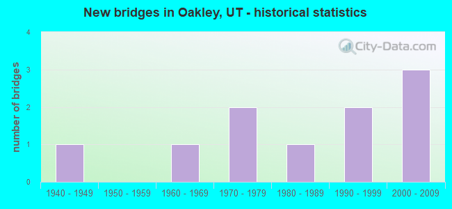
- New bridges - historical statistics
- 11940-1949
- 11960-1969
- 21970-1979
- 11980-1989
- 21990-1999
- 32000-2009

- Reconstructed bridges - Historical Statistics
- 21980-1989
- 01990-1999
- 12000-2009


- Bridge Condition - Deck
- 77.8%Satisfactory
- 22.2%Fair

- Bridge Condition - Superstructure
- 11.1%Very good
- 22.2%Good
- 22.2%Satisfactory
- 44.4%Fair

- Bridge Condition - Substructure
- 33.3%Good
- 33.3%Satisfactory
- 33.3%Fair

- Bridge Condition - Channel
- 20.0%Very good
- 30.0%Good
- 50.0%Satisfactory
Find on map >> Show street view
Structure Number: 43012F, Location: 2 MILES SE. OF OAKLEY (Lat: 40.705856, Lng: -111.270458), Route carried "on" structure: County highway 2594, Year Built: 1961, Status: Posted for load, Structure Length: 1.58m (5.18ft), Average Daily Traffic: 1,000 (year 2020), Truck Traffic: 2%, Average Future Daily Traffic: 1,250 (year 2040), Design Load: HL 93, Features Intersected: WEBER-PROVO DIV. CANAL, Facility Carried by Structure: COUNTY ROAD
Minimum Vertical Clearance: 30+ m (98+ ft), Kilometerpoint: 1.285, Lanes on structure: 2, Owner: County Highway Agency, Approaching Roadway Width: 6.1m (20.0ft), Material/Design: Prestressed concrete, Design/Construction: Tee Beam, Number Of Spans In Main Unit: 3, Length of Maximum Span: 5.5m (18.0ft), Curb-To-Curb Width: 6.1m (20.0ft), Out-to-Out Width: 6.5m (21.3ft)
Condition: Deck: Satisfactory, Superstructure: Satisfactory, Substructure: Satisfactory, Channel: Good, Operating Rating: 44.7 metric tons, Method Used To Determine Operating Rating: Load and Resistance Factor Rating (LRFR) rating reported by rating factor(RF) method using HL-93 loadings, Inventory Rating: 24.3 metric tons, Method Used To Determine Inventory Rating: Load Factor (LF) rating reported by rating factor (RF) method using MS18 loading, Structural Evaluation: Equal to present minimum criteria, Deck Geometry: High priority of corrective action, Waterway Adequacy: Better than present minimum criteria, Approach Roadway Alignment: Equal to present desirable criteria, Designated Inspection Frequency: Every 25 months, Inspection Date: May 2020, Deck Structure Type: Concrete Precast Panels, Wearing Surface/Protective System: Wearing Surface: Bituminous
Find on map >> Show street view
Structure Number: 43013C, Location: EAST SIDE OF OAKLEY (Lat: 40.730639, Lng: -111.255050), Route carried "on" structure: City street 2594, Year Built: 1986, Status: Posted for load, Structure Length: 2.17m (7.12ft), Average Daily Traffic: 1,000 (year 2020), Truck Traffic: 4%, Average Future Daily Traffic: 1,250 (year 2040), Design Load: HS 20+Mod, Features Intersected: WEBER RIVER, Facility Carried by Structure: TOWN STREET
Minimum Vertical Clearance: 30+ m (98+ ft), Kilometerpoint: 5.430, Lanes on structure: 2, Owner: Town or Township Highway Agency, Approaching Roadway Width: 6.5m (21.3ft), Material/Design: Steel, Design/Construction: Box Beam or Girders - Multiple, Number Of Spans In Main Unit: 1, Length of Maximum Span: 21.3m (69.9ft), Curb-To-Curb Width: 6.5m (21.3ft), Out-to-Out Width: 6.5m (21.3ft)
Condition: Deck: Satisfactory, Superstructure: Fair, Substructure: Satisfactory, Channel: Good, Operating Rating: 6.8 metric tons, Method Used To Determine Operating Rating: Load Factor (LF) rating reported by rating factor (RF) method using MS18 loading, Inventory Rating: 6.5 metric tons, Method Used To Determine Inventory Rating: Load Factor (LF) rating reported by rating factor (RF) method using MS18 loading, Structural Evaluation: High priority of corrective action, Deck Geometry: High priority of corrective action, Waterway Adequacy: Somewhat better than minimum adequacy, Approach Roadway Alignment: Better than present minimum criteria, Bridge Posting: Required (Relationship of Operating Rating to Maximum Legal Load: > 39.9% below), Designated Inspection Frequency: Every 26 months, Inspection Date: April 2020, Deck Structure Type: Wood or Timber, Wearing Surface/Protective System: Wearing Surface: Bituminous
Find on map >> Show street view
Structure Number: 43016C, Location: 6 MILES NE. OF OAKLEY (Lat: 40.750656, Lng: -111.193353), Route carried "on" structure: County highway , Year Built: 2003, Status: Open, Structure Length: 0.69m (2.26ft), Average Daily Traffic: 19 (year 2020), Average Future Daily Traffic: 23 (year 2040), Design Load: HS 20+Mod, Features Intersected: SOUTH FORK WEBER RIVER, Facility Carried by Structure: SOUTH FORK ROAD
Minimum Vertical Clearance: 30+ m (98+ ft), Kilometerpoint: 0.032, Lanes on structure: 1, Owner: County Highway Agency, Approaching Roadway Width: 5.8m (19.0ft), Material/Design: Steel, Design/Construction: Stringer/Multi-beam, Number Of Spans In Main Unit: 1, Length of Maximum Span: 6.4m (21.0ft), Curb-To-Curb Width: 5.8m (19.0ft), Out-to-Out Width: 5.8m (19.0ft)
Condition: Deck: Satisfactory, Superstructure: Good, Substructure: Good, Channel: Good, Operating Rating: 70.6 metric tons, Method Used To Determine Operating Rating: Load Factor (LF) rating reported by rating factor (RF) method using MS18 loading, Inventory Rating: 50.2 metric tons, Method Used To Determine Inventory Rating: Load Factor (LF) rating reported by rating factor (RF) method using MS18 loading, Structural Evaluation: Better than present minimum criteria, Deck Geometry: Meets minimum limits, Waterway Adequacy: Better than present minimum criteria, Approach Roadway Alignment: Equal to present minimum criteria, Designated Inspection Frequency: Every 25 months, Inspection Date: May 2020, Deck Structure Type: Wood or Timber, Wearing Surface/Protective System: Wearing Surface: Wood or Timber
Find on map >> Show street view
Structure Number: 43017C, Location: 4.5 MILES NE. OF OAKLEY (Lat: 40.749586, Lng: -111.222656), Route carried "on" structure: County highway , Year Built: 2000, Status: Open, Structure Length: 1.71m (5.61ft), Average Daily Traffic: 19 (year 2020), Average Future Daily Traffic: 23 (year 2040), Design Load: HS 20+Mod, Features Intersected: WEBER RIVER, Facility Carried by Structure: SOUTH FORK ROAD
Minimum Vertical Clearance: 30+ m (98+ ft), Kilometerpoint: 0.121, Lanes on structure: 1, Owner: County Highway Agency, Approaching Roadway Width: 4.3m (14.1ft), Material/Design: Steel, Design/Construction: Girder and Floorbeam System, Number Of Spans In Main Unit: 1, Length of Maximum Span: 14.3m (46.9ft), Curb-To-Curb Width: 4.3m (14.1ft), Out-to-Out Width: 4.3m (14.1ft)
Condition: Deck: Satisfactory, Superstructure: Satisfactory, Substructure: Satisfactory, Channel: Satisfactory, Operating Rating: 36.3 metric tons, Method Used To Determine Operating Rating: Load Factor (LF) rating reported by rating factor (RF) method using MS18 loading, Inventory Rating: 24.6 metric tons, Method Used To Determine Inventory Rating: Load Factor (LF) rating reported by rating factor (RF) method using MS18 loading, Structural Evaluation: Equal to present minimum criteria, Deck Geometry: Equal to present minimum criteria, Waterway Adequacy: Somewhat better than minimum adequacy, Approach Roadway Alignment: Equal to present minimum criteria, Designated Inspection Frequency: Every 25 months, Inspection Date: May 2020, Deck Structure Type: Corrugated Steel, Wearing Surface/Protective System: Wearing Surface: Monolithic Concrete
Find on map >> Show street view
Structure Number: 43022F, Location: 1 MILE EAST OF OAKLEY (Lat: 40.715453, Lng: -111.281081), Route carried "on" structure: County highway , Year Built: 1974, Year Reconstructed: 1994, Status: Posted for load, Structure Length: 1.37m (4.49ft), Average Daily Traffic: 252 (year 2020), Average Future Daily Traffic: 306 (year 2040), Design Load: HL 93, Features Intersected: WEBER RIVER, Facility Carried by Structure: COUNTY ROAD
Minimum Vertical Clearance: 30+ m (98+ ft), Kilometerpoint: 1.078, Lanes on structure: 2, Owner: County Highway Agency, Approaching Roadway Width: 8.2m (26.9ft), Skew: 1 degrees, Material/Design: Prestressed concrete, Design/Construction: Tee Beam, Number Of Spans In Main Unit: 1, Length of Maximum Span: 12.9m (42.3ft), Curb-To-Curb Width: 8.2m (26.9ft), Out-to-Out Width: 9.1m (29.9ft)
Condition: Deck: Satisfactory, Superstructure: Fair, Substructure: Fair, Channel: Satisfactory, Operating Rating: 46.0 metric tons, Method Used To Determine Operating Rating: Load and Resistance Factor Rating (LRFR) rating reported by rating factor(RF) method using HL-93 loadings, Inventory Rating: 32.4 metric tons, Method Used To Determine Inventory Rating: Load Factor (LF) rating reported by rating factor (RF) method using MS18 loading, Structural Evaluation: Somewhat better than minimum adequacy, Deck Geometry: Somewhat better than minimum adequacy, Waterway Adequacy: Somewhat better than minimum adequacy, Approach Roadway Alignment: Equal to present desirable criteria, Designated Inspection Frequency: Every 26 months, Inspection Date: April 2020, Deck Structure Type: Concrete Precast Panels, Wearing Surface/Protective System: Wearing Surface: Bituminous
Find on map >> Show street view
Structure Number: 43043D, Location: SOUTH SIDE OF OAKLEY (Lat: 40.708664, Lng: -111.293397), Route carried "on" structure: City street , Year Built: 1991, Status: Posted for load, Structure Length: 0.96m (3.15ft), Average Daily Traffic: 101 (year 2020), Average Future Daily Traffic: 122 (year 2040), Design Load: HL 93, Features Intersected: WEBER RIVER, Facility Carried by Structure: RIVER ROAD
Minimum Vertical Clearance: 30+ m (98+ ft), Kilometerpoint: 0.399, Lanes on structure: 2, Owner: Town or Township Highway Agency, Approaching Roadway Width: 7.2m (23.6ft), Material/Design: Concrete, Design/Construction: Frame, Number Of Spans In Main Unit: 1, Length of Maximum Span: 9.0m (29.5ft), Curb-To-Curb Width: 7.2m (23.6ft), Out-to-Out Width: 7.7m (25.3ft)
Condition: Deck: Fair, Superstructure: Fair, Substructure: Fair, Channel: Satisfactory, Operating Rating: 44.1 metric tons, Method Used To Determine Operating Rating: Load and Resistance Factor Rating (LRFR) rating reported by rating factor(RF) method using HL-93 loadings, Inventory Rating: 32.4 metric tons, Method Used To Determine Inventory Rating: Load Factor (LF) rating reported by rating factor (RF) method using MS18 loading, Structural Evaluation: Somewhat better than minimum adequacy, Deck Geometry: Meets minimum limits, Waterway Adequacy: Better than present minimum criteria, Approach Roadway Alignment: Better than present minimum criteria, Designated Inspection Frequency: Every 26 months, Inspection Date: April 2020, Deck Structure Type: Concrete Precast Panels, Wearing Surface/Protective System: Wearing Surface: Bituminous
Find on map >> Show street view
Structure Number: 43044C, Location: SOUTHWEST SIDE OF OAKLEY (Lat: 40.709031, Lng: -111.300225), Route carried "on" structure: City street , Year Built: 1945, Year Reconstructed: 1986, Status: Posted for load, Structure Length: 1.60m (5.25ft), Average Daily Traffic: 101 (year 2020), Average Future Daily Traffic: 122 (year 2040), Design Load: H 15, Features Intersected: WEBER RIVER, Facility Carried by Structure: MILLRACE RD.OAKLEY
Minimum Vertical Clearance: 30+ m (98+ ft), Kilometerpoint: 0.364, Lanes on structure: 2, Owner: Town or Township Highway Agency, Approaching Roadway Width: 7.0m (23.0ft), Skew: 2 degrees, Material/Design: Steel, Design/Construction: Stringer/Multi-beam, Number Of Spans In Main Unit: 1, Length of Maximum Span: 13.7m (44.9ft), Curb-To-Curb Width: 7.0m (23.0ft), Out-to-Out Width: 7.3m (24.0ft)
Condition: Deck: Fair, Superstructure: Fair, Substructure: Fair, Channel: Satisfactory, Operating Rating: 35.6 metric tons, Method Used To Determine Operating Rating: Load Factor (LF) rating reported by rating factor (RF) method using MS18 loading, Inventory Rating: 20.4 metric tons, Method Used To Determine Inventory Rating: Load Factor (LF) rating reported by rating factor (RF) method using MS18 loading, Structural Evaluation: Somewhat better than minimum adequacy, Deck Geometry: Meets minimum limits, Waterway Adequacy: Better than present minimum criteria, Approach Roadway Alignment: Better than present minimum criteria, Designated Inspection Frequency: Every 26 months, Inspection Date: April 2020, Deck Structure Type: Corrugated Steel, Wearing Surface/Protective System: Wearing Surface: Bituminous
Find on map >> Show street view
Structure Number: 43052C, Location: 6 MILES NE. OF OAKLEY (Lat: 40.750022, Lng: -111.192067), Route carried "on" structure: County highway , Year Built: 2007, Status: Open, Structure Length: 0.67m (2.20ft), Average Daily Traffic: 13 (year 2020), Truck Traffic: 5%, Average Future Daily Traffic: 15 (year 2040), Design Load: HS 20+Mod, Features Intersected: SOUTH FORK WEBER RIVER, Facility Carried by Structure: SOUTH FORK ROAD
Minimum Vertical Clearance: 30+ m (98+ ft), Kilometerpoint: 0.117, Lanes on structure: 2, Owner: County Highway Agency, Approaching Roadway Width: 4.9m (16.1ft), Material/Design: Steel, Design/Construction: Stringer/Multi-beam, Number Of Spans In Main Unit: 1, Length of Maximum Span: 6.4m (21.0ft), Curb-To-Curb Width: 4.9m (16.1ft), Out-to-Out Width: 5.8m (19.0ft)
Condition: Deck: Satisfactory, Superstructure: Very good, Substructure: Good, Channel: Very good, Operating Rating: 40.2 metric tons, Method Used To Determine Operating Rating: Load and Resistance Factor Rating (LRFR) rating reported by rating factor(RF) method using HL-93 loadings, Inventory Rating: 29.5 metric tons, Method Used To Determine Inventory Rating: Load and Resistance Factor Rating (LRFR) rating reported by rating factor(RF) method using HL-93 loadings, Structural Evaluation: Better than present minimum criteria, Deck Geometry: High priority of corrective action, Waterway Adequacy: Equal to present desirable criteria, Approach Roadway Alignment: Equal to present desirable criteria, Designated Inspection Frequency: Every 25 months, Inspection Date: May 2020, Deck Structure Type: Wood or Timber, Wearing Surface/Protective System: Wearing Surface: Wood or Timber
Find on map >> Show street view
Structure Number: F 601, Location: WITHIN TOWN OF OAKLEY (Lat: 40.709100, Lng: -111.292650), Route carried "on" structure: State highway 32, Year Built: 1997, Status: Open, Structure Length: 2.43m (7.97ft), Average Daily Traffic: 2,697 (year 2020), Truck Traffic: 28%, Average Future Daily Traffic: 3,371 (year 2040), Design Load: HS 20+Mod, Features Intersected: WEBER RIVER
Minimum Vertical Clearance: 30+ m (98+ ft), Kilometerpoint: 28.158, Lanes on structure: 2, Owner: State Highway Agency, Approaching Roadway Width: 12.2m (40.0ft), Skew: 2 degrees, Material/Design: Prestressed concrete, Design/Construction: Stringer/Multi-beam, Number Of Spans In Main Unit: 1, Length of Maximum Span: 23.5m (77.1ft), Curb or Sidewalk Widths: Left: 0.0m, Right: 2.0m (6.6ft), Curb-To-Curb Width: 13.4m (44.0ft), Out-to-Out Width: 16.5m (54.1ft)
Condition: Deck: Satisfactory, Superstructure: Good, Substructure: Good, Channel: Very good, Operating Rating: 46.0 metric tons, Method Used To Determine Operating Rating: Load and Resistance Factor Rating (LRFR) rating reported by rating factor(RF) method using HL-93 loadings, Inventory Rating: 42.4 metric tons, Method Used To Determine Inventory Rating: Load Factor (LF) rating reported by rating factor (RF) method using MS18 loading, Structural Evaluation: Better than present minimum criteria, Deck Geometry: Better than present minimum criteria, Waterway Adequacy: Equal to present desirable criteria, Approach Roadway Alignment: Equal to present desirable criteria, Designated Inspection Frequency: Every 26 months, Inspection Date: June 2020, Deck Structure Type: Concrete Cast-file-Place, Wearing Surface/Protective System: Wearing Surface: Monolithic Concrete, Deck Protection: Epoxy Coated Reinforcing
Find on map >> Show street view
Structure Number: V1437, Location: WITHIN TOWN OF OAKLEY (Lat: 40.710031, Lng: -111.294572), Route carried "on" structure: State highway 32, Year Built: 1977, Year Reconstructed: 2000, Status: Open, Structure Length: 1.52m (4.99ft), Average Daily Traffic: 2,697 (year 2020), Truck Traffic: 28%, Average Future Daily Traffic: 3,371 (year 2040), Design Load: HS 20+Mod, Features Intersected: WEBER RIVER OVERFLOW
Minimum Vertical Clearance: 30.18m (99.02ft), Kilometerpoint: 28.350, Lanes on structure: 2, Owner: State Highway Agency, Approaching Roadway Width: 8.5m (27.9ft), Skew: 1 degrees, Material/Design: Steel, Design/Construction: Culvert, Number Of Spans In Main Unit: 5, Length of Maximum Span: 1.2m (3.9ft), Out-to-Out Width: 19.8m (65.0ft)
Condition: Channel: Satisfactory, Culverts: Fair, Operating Rating: 97.2 metric tons, Method Used To Determine Operating Rating: Load and Resistance Factor Rating (LRFR) rating reported by rating factor(RF) method using HL-93 loadings, Inventory Rating: 96.9 metric tons, Method Used To Determine Inventory Rating: Load and Resistance Factor Rating (LRFR) rating reported by rating factor(RF) method using HL-93 loadings, Structural Evaluation: Somewhat better than minimum adequacy, Waterway Adequacy: Equal to present minimum criteria, Approach Roadway Alignment: Equal to present desirable criteria, Designated Inspection Frequency: Every 26 months, Inspection Date: June 2020