Bridge Statistics for Oakvale, West Virginia (WV)
Condition, Traffic, Stress, Structural Evaluation, Project Costs
- National Bridge Inventory (NBI) Statistics
- 17Number of bridges
- 138ft / 42.4mTotal length
- $9,675,000Total costs
- 17,620Total average daily traffic
- 1,119Total average daily truck traffic
- National Bridge Inventory (NBI) Registered Bridges for Oakvale
- No street view available for this location
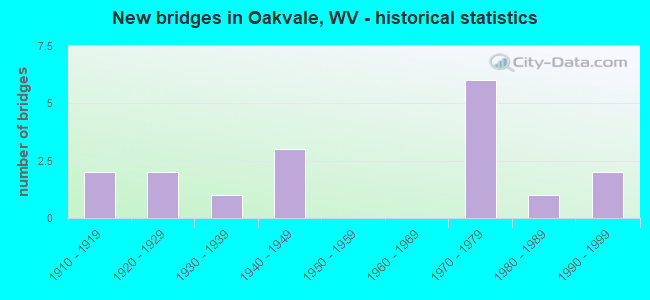
- New bridges - historical statistics
- 21910-1919
- 21920-1929
- 11930-1939
- 31940-1949
- 61970-1979
- 11980-1989
- 21990-1999


- Bridge Condition - Deck
- 9.1%Good
- 9.1%Satisfactory
- 36.4%Fair
- 45.5%Poor

- Bridge Condition - Superstructure
- 18.2%Satisfactory
- 63.6%Fair
- 18.2%Poor

- Bridge Condition - Substructure
- 63.6%Fair
- 36.4%Poor

- Bridge Condition - Channel
- 27.3%Very good
- 27.3%Good
- 18.2%Satisfactory
- 9.1%Fair
- 9.1%Poor
- 9.1%Serious
Find on map >> Show street view
Structure Number: 28A089, Location: 0.02 MI N OF CR 35 (Lat: 37.345939, Lng: -80.966411), Route carried "on" structure: County highway 2800, Year Built: 1988, Status: Open, Structure Length: 1.64m (5.38ft), Average Daily Traffic: 700 (year 2018), Truck Traffic: 2%, Average Future Daily Traffic: 847 (year 2038), Design Load: HS 20, Features Intersected: FIVE MILE CREEK, Facility Carried by Structure: COUNTY ROUTE 28
Minimum Vertical Clearance: 30+ m (98+ ft), Kilometerpoint: 0.032, Lanes on structure: 2, Owner: State Highway Agency, Approaching Roadway Width: 7.3m (24.0ft), Material/Design: Prestressed concrete, Design/Construction: Box Beam or Girders - Multiple, Number Of Spans In Main Unit: 1, Length of Maximum Span: 15.2m (49.9ft), Curb-To-Curb Width: 7.6m (24.9ft), Out-to-Out Width: 8.6m (28.2ft)
Condition: Deck: Fair, Superstructure: Fair, Substructure: Fair, Channel: Satisfactory, Operating Rating: 75.3 metric tons, Method Used To Determine Operating Rating: Load Factor (LF), Inventory Rating: 44.4 metric tons, Method Used To Determine Inventory Rating: Load Factor (LF), Structural Evaluation: Somewhat better than minimum adequacy, Deck Geometry: Meets minimum limits, Waterway Adequacy: Equal to present desirable criteria, Approach Roadway Alignment: Somewhat better than minimum adequacy, Designated Inspection Frequency: Every 24 months, Inspection Date: October 2020, Deck Structure Type: Other, Wearing Surface/Protective System: Wearing Surface: Bituminous, Deck Protection: Epoxy Coated Reinforcing
Find on map >> Show street view
Structure Number: 28A09, Location: 0.03 MI N OF CR 28/6 (Lat: 37.352450, Lng: -80.959981), Route carried "on" structure: County highway 2800, Year Built: 1946, Status: Posted for load, Structure Length: 1.13m (3.71ft), Average Daily Traffic: 700 (year 2019), Truck Traffic: 6%, Average Future Daily Traffic: 840 (year 2039), Features Intersected: HALES BRANCH, Facility Carried by Structure: CR 28
Minimum Vertical Clearance: 30+ m (98+ ft), Kilometerpoint: 1.255, Lanes on structure: 2, Owner: State Highway Agency, Approaching Roadway Width: 7.3m (24.0ft), Skew: 4 degrees, Material/Design: Concrete, Design/Construction: Slab, Number Of Spans In Main Unit: 2, Length of Maximum Span: 4.9m (16.1ft), Curb or Sidewalk Widths: Left: 0.2m (0.7ft), Right: 0.2m (0.7ft), Curb-To-Curb Width: 8.1m (26.6ft), Out-to-Out Width: 8.6m (28.2ft)
Condition: Deck: Poor, Superstructure: Poor, Substructure: Poor, Channel: Poor, Operating Rating: 45.4 metric tons, Method Used To Determine Operating Rating: Field evaluation and documented engineering judgment, Inventory Rating: 20.0 metric tons, Method Used To Determine Inventory Rating: Field evaluation and documented engineering judgment, Structural Evaluation: Meets minimum limits, Deck Geometry: Somewhat better than minimum adequacy, Waterway Adequacy: Equal to present minimum criteria, Approach Roadway Alignment: Better than present minimum criteria, Length Of Structure Improvement: 1.13m (3.71ft), Designated Inspection Frequency: Every 24 months, Inspection Date: December 2021, Bridge Improvement Cost: $400,000, Roadway Improvement Cost: $50,000, Total Project Cost: $450,000 ( Estimate for 2022), Deck Structure Type: Concrete Cast-file-Place, Wearing Surface/Protective System: Wearing Surface: Bituminous
Find on map >> Show street view
Structure Number: 28A095, Location: 0.01 MI S OF WV 112 (Lat: 37.313361, Lng: -81.027789), Route carried "on" structure: County highway 3803, Year Built: 1979, Status: Posted for load, Structure Length: 1.46m (4.79ft), Average Daily Traffic: 100 (year 2019), Truck Traffic: 6%, Average Future Daily Traffic: 120 (year 2039), Features Intersected: EAST RIVER, Facility Carried by Structure: CR 38/3
Minimum Vertical Clearance: 30+ m (98+ ft), Kilometerpoint: 0.016, Lanes on structure: 1, Owner: State Highway Agency, Approaching Roadway Width: 4.3m (14.1ft), Material/Design: Steel, Design/Construction: Girder and Floorbeam System, Number Of Spans In Main Unit: 1, Length of Maximum Span: 13.3m (43.6ft), Curb or Sidewalk Widths: Left: 0.2m (0.7ft), Right: 0.2m (0.7ft), Curb-To-Curb Width: 4.4m (14.4ft), Out-to-Out Width: 4.9m (16.1ft)
Condition: Deck: Fair, Superstructure: Fair, Substructure: Fair, Channel: Fair, Operating Rating: 30.8 metric tons, Method Used To Determine Operating Rating: Load Factor (LF), Inventory Rating: 18.1 metric tons, Method Used To Determine Inventory Rating: Load Factor (LF), Structural Evaluation: Somewhat better than minimum adequacy, Deck Geometry: Equal to present minimum criteria, Waterway Adequacy: Meets minimum limits, Approach Roadway Alignment: Meets minimum limits, Bridge Posting: Required (Relationship of Operating Rating to Maximum Legal Load: 20.0 - 29.9% below), Length Of Structure Improvement: 1.46m (4.79ft), Designated Inspection Frequency: Every 24 months, Critical Feature Inspection Frequency: Every 24 months, Other Special Inspection Frequency: Every 12 months, Inspection Date: December 2020, Critical Feature Inspection Date: December 2020, Other Special Inspection Date: December 2021, Bridge Improvement Cost: $350,000, Roadway Improvement Cost: $100,000, Total Project Cost: $450,000 ( Estimate for 2022), Deck Structure Type: Wood or Timber, Wearing Surface/Protective System: Wearing Surface: Wood or Timber
Find on map >> Show street view
Structure Number: 28A125, Location: 1.70 MI E OF CR 460/12 (Lat: 37.357839, Lng: -80.977450), Route carried "on" structure: County highway 21903, Year Built: 1990, Status: Open, Structure Length: 1.33m (4.36ft), Average Daily Traffic: 100 (year 2018), Truck Traffic: 2%, Average Future Daily Traffic: 121 (year 2038), Design Load: HS 20, Features Intersected: PAYNE BRANCH, Facility Carried by Structure: CR 219/3
Minimum Vertical Clearance: 30+ m (98+ ft), Kilometerpoint: 7.242, Lanes on structure: 2, Owner: State Highway Agency, Approaching Roadway Width: 4.3m (14.1ft), Skew: 2 degrees, Material/Design: Prestressed concrete, Design/Construction: Box Beam or Girders - Multiple, Number Of Spans In Main Unit: 1, Length of Maximum Span: 12.1m (39.7ft), Curb-To-Curb Width: 6.4m (21.0ft), Out-to-Out Width: 6.4m (21.0ft)
Condition: Deck: Satisfactory, Superstructure: Satisfactory, Substructure: Fair, Channel: Good, Operating Rating: 88.9 metric tons, Method Used To Determine Operating Rating: Load Factor (LF), Inventory Rating: 62.6 metric tons, Method Used To Determine Inventory Rating: Load Factor (LF), Structural Evaluation: Somewhat better than minimum adequacy, Deck Geometry: Somewhat better than minimum adequacy, Waterway Adequacy: Equal to present desirable criteria, Approach Roadway Alignment: Somewhat better than minimum adequacy, Designated Inspection Frequency: Every 24 months, Inspection Date: December 2020, Deck Structure Type: Other, Wearing Surface/Protective System: Wearing Surface: Bituminous, Deck Protection: Epoxy Coated Reinforcing
Find on map >> Show street view
Structure Number: 28A127, Location: 0.06 MI S OF CR 460/6 (Lat: 37.335789, Lng: -80.950589), Route carried "on" structure: County highway 21906, Year Built: 1943, Status: Open, Structure Length: 2.71m (8.89ft), Average Daily Traffic: 200 (year 2019), Truck Traffic: 6%, Average Future Daily Traffic: 240 (year 2039), Features Intersected: EAST RIVER, Facility Carried by Structure: CR 219/6
Minimum Vertical Clearance: 30+ m (98+ ft), Kilometerpoint: 0.097, Lanes on structure: 1, Owner: State Highway Agency, Approaching Roadway Width: 4.3m (14.1ft), Material/Design: Steel, Design/Construction: Stringer/Multi-beam, Number Of Spans In Main Unit: 1, Number Of Approach Spans: 2, Length of Maximum Span: 8.9m (29.2ft), Curb or Sidewalk Widths: Left: 0.2m (0.7ft), Right: 0.2m (0.7ft), Curb-To-Curb Width: 3.9m (12.8ft), Out-to-Out Width: 4.3m (14.1ft)
Condition: Deck: Good, Superstructure: Fair, Substructure: Poor, Channel: Serious, Operating Rating: 49.0 metric tons, Method Used To Determine Operating Rating: Load Factor (LF), Inventory Rating: 29.0 metric tons, Method Used To Determine Inventory Rating: Load Factor (LF), Structural Evaluation: Meets minimum limits, Deck Geometry: High priority of replacement, Waterway Adequacy: Somewhat better than minimum adequacy, Approach Roadway Alignment: Somewhat better than minimum adequacy, Length Of Structure Improvement: 2.71m (8.89ft), Designated Inspection Frequency: Every 24 months, Other Special Inspection Frequency: Every 12 months, Inspection Date: July 2021, Other Special Inspection Date: July 2021, Bridge Improvement Cost: $800,000, Roadway Improvement Cost: $100,000, Total Project Cost: $900,000 ( Estimate for 2020), Deck Structure Type: Wood or Timber, Wearing Surface/Protective System: Wearing Surface: Wood or Timber
Find on map >> Show street view
Structure Number: 28A137, Location: 0.10 MI E OF WV 112 (Lat: 37.342869, Lng: -80.956700), Route carried "on" structure: US 46000, Year Built: 1972, Status: Open, Structure Length: 14.45m (47.41ft), Average Daily Traffic: 5,250 (year 2018), Truck Traffic: 7%, Average Future Daily Traffic: 6,353 (year 2038), Design Load: HS 20, Features Intersected: CO 35, Facility Carried by Structure: US 460 EASTBOUND
Minimum Vertical Clearance: 30+ m (98+ ft), Kilometerpoint: 34.923, Lanes on structure: 2, Lanes under structure: 2, Base Highway Network: Yes, Owner: State Highway Agency, Approaching Roadway Width: 12.5m (41.0ft), Material/Design: Steel continuous, Design/Construction: Stringer/Multi-beam, Number Of Spans In Main Unit: 2, Number Of Approach Spans: 2, Length of Maximum Span: 41.1m (134.8ft), Curb-To-Curb Width: 12.3m (40.4ft), Out-to-Out Width: 13.6m (44.6ft)
Condition: Deck: Fair, Superstructure: Satisfactory, Substructure: Fair, Channel: Very good, Operating Rating: 68.9 metric tons, Method Used To Determine Operating Rating: Load Factor (LF), Inventory Rating: 41.7 metric tons, Method Used To Determine Inventory Rating: Load Factor (LF), Structural Evaluation: Somewhat better than minimum adequacy, Deck Geometry: Better than present minimum criteria, Underclear: Meets minimum limits, Waterway Adequacy: Superior to present desirable criteria, Approach Roadway Alignment: Equal to present desirable criteria, Length Of Structure Improvement: 14.45m (47.41ft), Designated Inspection Frequency: Every 24 months, Inspection Date: October 2020, Bridge Improvement Cost: $3,500,000, Roadway Improvement Cost: $500,000, Total Project Cost: $4,000,000 ( Estimate for 2020), Deck Structure Type: Concrete Cast-file-Place, Wearing Surface/Protective System: Wearing Surface: Latex Concrete
Find on map >> Show street view
Structure Number: 28A138, Location: 0.52 MI E OF US 460 (Lat: 37.344869, Lng: -80.978761), Route carried "on" structure: County highway 3500, Year Built: 1930, Status: Open, Structure Length: 0.90m (2.95ft), Average Daily Traffic: 950 (year 2019), Truck Traffic: 6%, Average Future Daily Traffic: 1,140 (year 2039), Features Intersected: FIVEMILE CREEK, Facility Carried by Structure: CR 35
Minimum Vertical Clearance: 30+ m (98+ ft), Kilometerpoint: 0.837, Lanes on structure: 2, Owner: State Highway Agency, Approaching Roadway Width: 9.8m (32.2ft), Skew: 2 degrees, Material/Design: Concrete, Design/Construction: Slab, Number Of Spans In Main Unit: 1, Length of Maximum Span: 8.4m (27.6ft), Curb or Sidewalk Widths: Left: 0.1m (0.3ft), Right: 0.1m (0.3ft), Curb-To-Curb Width: 9.1m (29.9ft), Out-to-Out Width: 10.0m (32.8ft)
Condition: Deck: Fair, Superstructure: Fair, Substructure: Fair, Channel: Good, Operating Rating: 47.2 metric tons, Method Used To Determine Operating Rating: Field evaluation and documented engineering judgment, Inventory Rating: 21.8 metric tons, Method Used To Determine Inventory Rating: Field evaluation and documented engineering judgment, Structural Evaluation: Somewhat better than minimum adequacy, Deck Geometry: Equal to present minimum criteria, Waterway Adequacy: Equal to present desirable criteria, Approach Roadway Alignment: Better than present minimum criteria, Length Of Structure Improvement: 0.90m (2.95ft), Designated Inspection Frequency: Every 24 months, Inspection Date: December 2021, Bridge Improvement Cost: $350,000, Roadway Improvement Cost: $75,000, Total Project Cost: $425,000 ( Estimate for 2022), Deck Structure Type: Concrete Cast-file-Place, Wearing Surface/Protective System: Wearing Surface: Bituminous
Find on map >> Show street view
Structure Number: 28A139, Location: 0.02 MI.E.OF WV 112 (Lat: 37.336481, Lng: -80.953019), Route carried "on" structure: County highway 46006, Year Built: 1940, Status: Open, Structure Length: 1.94m (6.36ft), Average Daily Traffic: 650 (year 2018), Truck Traffic: 2%, Average Future Daily Traffic: 787 (year 2038), Design Load: H 15, Features Intersected: FIVEMILE CREEK, Facility Carried by Structure: COUTNY ROUTE 460/6
Minimum Vertical Clearance: 30+ m (98+ ft), Kilometerpoint: 0.032, Lanes on structure: 2, Owner: State Highway Agency, Approaching Roadway Width: 10.4m (34.1ft), Material/Design: Steel, Design/Construction: Stringer/Multi-beam, Number Of Spans In Main Unit: 1, Length of Maximum Span: 18.3m (60.0ft), Curb-To-Curb Width: 7.3m (24.0ft), Out-to-Out Width: 8.3m (27.2ft)
Condition: Deck: Poor, Superstructure: Fair, Substructure: Fair, Channel: Satisfactory, Operating Rating: 57.1 metric tons, Method Used To Determine Operating Rating: Load Factor (LF), Inventory Rating: 34.5 metric tons, Method Used To Determine Inventory Rating: Load Factor (LF), Structural Evaluation: Somewhat better than minimum adequacy, Deck Geometry: Meets minimum limits, Waterway Adequacy: Equal to present desirable criteria, Approach Roadway Alignment: Somewhat better than minimum adequacy, Length Of Structure Improvement: 1.94m (6.36ft), Designated Inspection Frequency: Every 24 months, Inspection Date: November 2020, Bridge Improvement Cost: $550,000, Roadway Improvement Cost: $50,000, Total Project Cost: $600,000 ( Estimate for 2021), Deck Structure Type: Concrete Cast-file-Place, Wearing Surface/Protective System: Wearing Surface: Bituminous
Find on map >> Show street view
Structure Number: 28A152, Location: 0.10 MI E OF WV 112 (Lat: 37.343169, Lng: -80.956711), Route carried "on" structure: US 46000, Year Built: 1972, Status: Open, Structure Length: 14.44m (47.38ft), Average Daily Traffic: 5,250 (year 2018), Truck Traffic: 7%, Average Future Daily Traffic: 6,353 (year 2038), Design Load: HS 20, Features Intersected: CR.35 & Fivemile Creek, Facility Carried by Structure: US 460 WB
Minimum Vertical Clearance: 30+ m (98+ ft), Kilometerpoint: 34.923, Lanes on structure: 2, Lanes under structure: 2, Base Highway Network: Yes, Owner: State Highway Agency, Approaching Roadway Width: 12.5m (41.0ft), Skew: 10 degrees, Material/Design: Steel continuous, Design/Construction: Stringer/Multi-beam, Number Of Spans In Main Unit: 2, Number Of Approach Spans: 2, Length of Maximum Span: 41.1m (134.8ft), Curb-To-Curb Width: 12.3m (40.4ft), Out-to-Out Width: 13.6m (44.6ft)
Condition: Deck: Poor, Superstructure: Fair, Substructure: Poor, Channel: Very good, Operating Rating: 68.9 metric tons, Method Used To Determine Operating Rating: Load Factor (LF), Inventory Rating: 41.7 metric tons, Method Used To Determine Inventory Rating: Load Factor (LF), Structural Evaluation: Meets minimum limits, Deck Geometry: Better than present minimum criteria, Underclear: Meets minimum limits, Waterway Adequacy: Superior to present desirable criteria, Approach Roadway Alignment: Equal to present desirable criteria, Length Of Structure Improvement: 14.44m (47.38ft), Designated Inspection Frequency: Every 24 months, Inspection Date: October 2020, Bridge Improvement Cost: $1,500,000, Roadway Improvement Cost: $500,000, Total Project Cost: $2,000,000 ( Estimate for 2020), Deck Structure Type: Concrete Cast-file-Place, Wearing Surface/Protective System: Wearing Surface: Latex Concrete
Find on map >> Show street view
Structure Number: 28A321, Location: 0.23 MILES WEST OF CO 26 (Lat: 37.347219, Lng: -80.974539), Route carried "on" structure: County highway 2602, Year Built: 1928, Status: Posted for load, Structure Length: 1.00m (3.28ft), Average Daily Traffic: 50 (year 2019), Truck Traffic: 6%, Average Future Daily Traffic: 60 (year 2039), Features Intersected: PAYNES BRANCH, Facility Carried by Structure: COUNTY ROUTE 26/2
Minimum Vertical Clearance: 30+ m (98+ ft), Kilometerpoint: 0.370, Lanes on structure: 1, Owner: State Highway Agency, Approaching Roadway Width: 3.0m (9.8ft), Material/Design: Concrete, Design/Construction: Stringer/Multi-beam, Number Of Spans In Main Unit: 1, Length of Maximum Span: 9.5m (31.2ft), Curb or Sidewalk Widths: Left: 0.2m (0.7ft), Right: 0.2m (0.7ft), Curb-To-Curb Width: 4.1m (13.5ft), Out-to-Out Width: 5.2m (17.1ft)
Condition: Deck: Poor, Superstructure: Poor, Substructure: Fair, Channel: Very good, Operating Rating: 39.9 metric tons, Method Used To Determine Operating Rating: Field evaluation and documented engineering judgment, Inventory Rating: 18.1 metric tons, Method Used To Determine Inventory Rating: Field evaluation and documented engineering judgment, Structural Evaluation: Meets minimum limits, Deck Geometry: Somewhat better than minimum adequacy, Waterway Adequacy: Equal to present desirable criteria, Approach Roadway Alignment: Equal to present minimum criteria, Length Of Structure Improvement: 1.00m (3.28ft), Designated Inspection Frequency: Every 24 months, Inspection Date: July 2021, Bridge Improvement Cost: $350,000, Roadway Improvement Cost: $100,000, Total Project Cost: $450,000 ( Estimate for 2021), Deck Structure Type: Concrete Cast-file-Place
Find on map >> Show street view
Structure Number: 28A322, Location: 0.01 MI SOUTH OF WV 112 (Lat: 37.327000, Lng: -80.990511), Route carried "on" structure: County highway 11201, Year Built: 1995, Status: Open, Structure Length: 1.41m (4.63ft), Average Daily Traffic: 20 (year 2019), Truck Traffic: 6%, Average Future Daily Traffic: 24 (year 2039), Features Intersected: EAST RIVER, Facility Carried by Structure: COUNTY ROUTE 112/1
Minimum Vertical Clearance: 30+ m (98+ ft), Kilometerpoint: 0.016, Lanes on structure: 1, Owner: State Highway Agency, Approaching Roadway Width: 30.5m (100.1ft), Material/Design: Steel, Design/Construction: Stringer/Multi-beam, Number Of Spans In Main Unit: 1, Length of Maximum Span: 13.4m (44.0ft), Curb or Sidewalk Widths: Left: 0.2m (0.7ft), Right: 0.2m (0.7ft), Curb-To-Curb Width: 4.5m (14.8ft), Out-to-Out Width: 4.9m (16.1ft)
Condition: Deck: Poor, Superstructure: Fair, Substructure: Poor, Channel: Good, Operating Rating: 65.3 metric tons, Method Used To Determine Operating Rating: Load Factor (LF), Inventory Rating: 39.0 metric tons, Method Used To Determine Inventory Rating: Load Factor (LF), Structural Evaluation: Meets minimum limits, Deck Geometry: Equal to present minimum criteria, Waterway Adequacy: Equal to present minimum criteria, Approach Roadway Alignment: Meets minimum limits, Length Of Structure Improvement: 1.41m (4.63ft), Designated Inspection Frequency: Every 24 months, Inspection Date: August 2021, Bridge Improvement Cost: $350,000, Roadway Improvement Cost: $50,000, Total Project Cost: $400,000 ( Estimate for 2019), Deck Structure Type: Wood or Timber, Wearing Surface/Protective System: Wearing Surface: Wood or Timber
Find on map >> Show street view
Structure Number: 28A123, Location: 0.09 MI W OF CR 38/3 (Lat: 37.312250, Lng: -81.028569), Route carried "under" structure: State highway 11200, Year Built: 1922, Structure Length: 0. m, Average Daily Traffic: 300 (year 2018), Truck Traffic: 4%, Features Intersected: NS RAILWAY, Facility Carried by Structure: N S RAILROAD
Minimum Vertical Clearance: 3.53m (11.58ft), Kilometerpoint: 14.548, Lanes under structure: 2, Material/Design: Steel, Design/Construction: Girder and Floorbeam System, Length of Maximum Span: 12.9m (42.3ft)
Find on map >> Show street view
Structure Number: 28A124, Location: 1.77 MI. E. OF CR. 38/4 (Lat: 37.324219, Lng: -80.994461), Route carried "under" structure: State highway 11200, Year Built: 1918, Structure Length: 0. m, Average Daily Traffic: 300 (year 2019), Truck Traffic: 5%, Features Intersected: NORTHFORK & SOUTHERN RR, Facility Carried by Structure: NS RAILROAD
Minimum Vertical Clearance: 3.25m (10.66ft), Kilometerpoint: 18.153, Lanes under structure: 2, Material/Design: Steel, Design/Construction: Girder and Floorbeam System, Length of Maximum Span: 8.7m (28.5ft)
Find on map >> Show street view
Structure Number: 28A128, Location: 0.09 MI. S. OF 460/6 (Lat: 37.335319, Lng: -80.950661), Route carried "under" structure: County highway 21906, Year Built: 1912, Structure Length: 0. m, Average Daily Traffic: 200 (year 2018), Truck Traffic: 2%, Features Intersected: N&S RR., Facility Carried by Structure: N&S RR.
Minimum Vertical Clearance: 2.92m (9.58ft), Kilometerpoint: 0.145, Lanes under structure: 2, Length of Maximum Span: 13.0m (42.7ft)
Find on map >> Show street view
Structure Number: 28A137, Location: 0.10 MI E OF WV 112 (Lat: 37.342869, Lng: -80.956700), Route carried "under" structure: County highway 3500, Year Built: 1972, Structure Length: 0. m, Average Daily Traffic: 1,100 (year 0012), Truck Traffic: 6%, Features Intersected: CO 35, Facility Carried by Structure: US 460 EASTBOUND
Minimum Vertical Clearance: 21.95m (72.01ft), Kilometerpoint: 3.267, Lanes on structure: 2, Lanes under structure: 2, Length of Maximum Span: 41.1m (134.8ft)
Find on map >> Show street view
Structure Number: 28A14, Location: 1.43 MI W OF CR 219/8 (Lat: 37.347639, Lng: -80.918511), Route carried "under" structure: County highway 46006, Year Built: 1970, Structure Length: 0. m, Average Daily Traffic: 650 (year 2019), Truck Traffic: 6%, Features Intersected: N S RAILWAY, Facility Carried by Structure: N S RAILWAY
Minimum Vertical Clearance: 4.75m (15.58ft), Kilometerpoint: 3.476, Lanes under structure: 2, Material/Design: Steel, Design/Construction: Girder and Floorbeam System, Length of Maximum Span: 37.8m (124.0ft)
Find on map >> Show street view
Structure Number: 28A152, Location: 0.10 MI E OF WV 112 (Lat: 37.343069, Lng: -80.956650), Route carried "under" structure: County highway 3500, Year Built: 1972, Structure Length: 0. m, Average Daily Traffic: 1,100 (year 0009), Truck Traffic: 9%, Features Intersected: CR.35 & Fivemile Creek, Facility Carried by Structure: US 460 WB
Minimum Vertical Clearance: 21.95m (72.01ft), Kilometerpoint: 3.267, Lanes on structure: 2, Lanes under structure: 2, Length of Maximum Span: 41.1m (134.8ft)