Bridge Statistics for Oakwood, Ohio (OH)
Condition, Traffic, Stress, Structural Evaluation, Project Costs
- National Bridge Inventory (NBI) Statistics
- 10Number of bridges
- 207ft / 62.7mTotal length
- $2,288,000Total costs
- 480,245Total average daily traffic
- 50,388Total average daily truck traffic
- National Bridge Inventory (NBI) Registered Bridges for Oakwood
- No street view available for this location
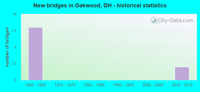
- New bridges - historical statistics
- 81960-1969
- 22010-2019

- Reconstructed bridges - Historical Statistics
- 11980-1989
- 31990-1999


- Bridge Condition - Deck
- 20.0%Excellent
- 20.0%Good
- 40.0%Satisfactory
- 20.0%Fair

- Bridge Condition - Superstructure
- 20.0%Excellent
- 60.0%Good
- 20.0%Satisfactory

- Bridge Condition - Substructure
- 20.0%Excellent
- 60.0%Good
- 20.0%Satisfactory
Find on map >> Show street view
Structure Number: 1810596, Location: JCT. I-271 WITH I-480 (Lat: 41.350869, Lng: -81.511511), Route carried "on" structure: Interstate 480, Year Built: 1964, Year Reconstructed: 2001, Status: Open, Structure Length: 16.61m (54.49ft), Average Daily Traffic: 26,249 (year 2015), Truck Traffic: 11%, Average Future Daily Traffic: 36,434 (year 2035), Design Load: HS 20+Mod, Features Intersected: IR 271 (CUY-271-0002)
Minimum Vertical Clearance: 30+ m (98+ ft), Kilometerpoint: 48.103, Lanes on structure: 2, Lanes under structure: 6, Base Highway Network: Yes, Owner: State Highway Agency, Approaching Roadway Width: 11.6m (38.1ft), Skew: 5 degrees, Material/Design: Steel continuous, Design/Construction: Stringer/Multi-beam, Number Of Spans In Main Unit: 5, Length of Maximum Span: 43.0m (141.1ft), Curb-To-Curb Width: 12.6m (41.3ft), Out-to-Out Width: 13.6m (44.6ft)
Condition: Deck: Good, Superstructure: Satisfactory, Substructure: Satisfactory, Operating Rating: 42.1 metric tons, Method Used To Determine Operating Rating: Allowable Stress (AS) rating reported by rating factor (RF) method using MS18 loading, Inventory Rating: 32.4 metric tons, Method Used To Determine Inventory Rating: Allowable Stress (AS) rating reported by rating factor (RF) method using MS18 loading, Structural Evaluation: Equal to present minimum criteria, Deck Geometry: Better than present minimum criteria, Underclear: Somewhat better than minimum adequacy, Approach Roadway Alignment: Equal to present desirable criteria, Length Of Structure Improvement: 16.61m (54.49ft), Designated Inspection Frequency: Every 12 months, Inspection Date: November 2021, Bridge Improvement Cost: $2,057,000, Roadway Improvement Cost: $229,000, Total Project Cost: $2,286,000, Deck Structure Type: Concrete Cast-file-Place, Wearing Surface/Protective System: Wearing Surface: Monolithic Concrete
Find on map >> Show street view
Structure Number: 1810626, Location: 0.52 MI. N. OF JCT. I-480 (Lat: 41.358019, Lng: -81.514819), Route carried "on" structure: County highway 121, Year Built: 1962, Year Reconstructed: 2001, Status: Open, Structure Length: 12.59m (41.31ft), Average Daily Traffic: 14,046 (year 2016), Truck Traffic: 5%, Average Future Daily Traffic: 19,496 (year 2036), Design Load: HS 20+Mod, Features Intersected: IR-271 (ALEXANDER), Facility Carried by Structure: ALEXANDER RD.
Minimum Vertical Clearance: 30+ m (98+ ft), Kilometerpoint: 10.234, Lanes on structure: 4, Lanes under structure: 6, Owner: State Highway Agency, Approaching Roadway Width: 22.6m (74.1ft), Skew: 1 degrees, Material/Design: Steel continuous, Design/Construction: Stringer/Multi-beam, Number Of Spans In Main Unit: 6, Length of Maximum Span: 22.6m (74.1ft), Curb or Sidewalk Widths: Left: 1.2m (3.9ft), Right: 1.2m (3.9ft), Curb-To-Curb Width: 20.1m (65.9ft), Out-to-Out Width: 23.4m (76.8ft)
Condition: Deck: Satisfactory, Superstructure: Good, Substructure: Good, Operating Rating: 42.1 metric tons, Method Used To Determine Operating Rating: Load Factor (LF) rating reported by rating factor (RF) method using MS18 loading, Inventory Rating: 32.4 metric tons, Method Used To Determine Inventory Rating: Load Factor (LF) rating reported by rating factor (RF) method using MS18 loading, Structural Evaluation: Better than present minimum criteria, Deck Geometry: Better than present minimum criteria, Underclear: Somewhat better than minimum adequacy, Approach Roadway Alignment: Equal to present desirable criteria, Designated Inspection Frequency: Every 12 months, Inspection Date: October 2021, Deck Structure Type: Concrete Cast-file-Place, Wearing Surface/Protective System: Wearing Surface: Monolithic Concrete, Deck Protection: Epoxy Coated Reinforcing
Find on map >> Show street view
Structure Number: 181065, Location: JCT. SR-14, CR12 & I-271 (Lat: 41.370581, Lng: -81.514489), Route carried "on" structure: County highway C0012, Year Built: 1962, Year Reconstructed: 2001, Status: Open, Structure Length: 16.34m (53.61ft), Average Daily Traffic: 14,422 (year 2015), Truck Traffic: 7%, Average Future Daily Traffic: 20,018 (year 2035), Design Load: HS 20+Mod, Features Intersected: I-271 (CUY-271-0146), Facility Carried by Structure: Broadway Ave
Minimum Vertical Clearance: 30+ m (98+ ft), Kilometerpoint: 21.340, Lanes on structure: 4, Lanes under structure: 6, Base Highway Network: Yes, Owner: State Highway Agency, Approaching Roadway Width: 18.9m (62.0ft), Skew: 4 degrees, Material/Design: Steel continuous, Design/Construction: Stringer/Multi-beam, Number Of Spans In Main Unit: 6, Length of Maximum Span: 29.9m (98.1ft), Curb or Sidewalk Widths: Left: 1.5m (4.9ft), Right: 1.5m (4.9ft), Curb-To-Curb Width: 16.5m (54.1ft), Out-to-Out Width: 19.7m (64.6ft)
Condition: Deck: Satisfactory, Superstructure: Good, Substructure: Good, Operating Rating: 87.8 metric tons, Method Used To Determine Operating Rating: Load Factor (LF) rating reported by rating factor (RF) method using MS18 loading, Inventory Rating: 52.5 metric tons, Method Used To Determine Inventory Rating: Load Factor (LF) rating reported by rating factor (RF) method using MS18 loading, Structural Evaluation: Better than present minimum criteria, Deck Geometry: Meets minimum limits, Underclear: Somewhat better than minimum adequacy, Approach Roadway Alignment: Equal to present desirable criteria, Designated Inspection Frequency: Every 12 months, Inspection Date: October 2021, Deck Structure Type: Concrete Cast-file-Place, Wearing Surface/Protective System: Wearing Surface: Monolithic Concrete, Membrane: Built-up
Find on map >> Show street view
Structure Number: 1810685, Location: .14 MI. N. OF JCT. SR-14 (Lat: 41.372769, Lng: -81.515289), Route carried "on" structure: County highway 123, Year Built: 1962, Year Reconstructed: 1994, Status: Open, Structure Length: 12.19m (39.99ft), Average Daily Traffic: 6,286 (year 2015), Truck Traffic: 5%, Average Future Daily Traffic: 8,725 (year 2035), Design Load: HS 20+Mod, Features Intersected: IR-271(FORBES), Facility Carried by Structure: FORBES RD.
Minimum Vertical Clearance: 30+ m (98+ ft), Kilometerpoint: 0.966, Lanes on structure: 3, Lanes under structure: 6, Owner: State Highway Agency, Approaching Roadway Width: 14.6m (47.9ft), Skew: 1 degrees, Material/Design: Steel continuous, Design/Construction: Stringer/Multi-beam, Number Of Spans In Main Unit: 6, Length of Maximum Span: 22.3m (73.2ft), Curb or Sidewalk Widths: Left: 1.3m (4.3ft), Right: 1.3m (4.3ft), Curb-To-Curb Width: 12.2m (40.0ft), Out-to-Out Width: 15.5m (50.9ft)
Condition: Deck: Fair, Superstructure: Good, Substructure: Good, Operating Rating: 42.1 metric tons, Method Used To Determine Operating Rating: Allowable Stress (AS) rating reported by rating factor (RF) method using MS18 loading, Inventory Rating: 32.4 metric tons, Method Used To Determine Inventory Rating: Allowable Stress (AS) rating reported by rating factor (RF) method using MS18 loading, Structural Evaluation: Better than present minimum criteria, Deck Geometry: Meets minimum limits, Underclear: Somewhat better than minimum adequacy, Approach Roadway Alignment: Equal to present desirable criteria, Designated Inspection Frequency: Every 12 months, Inspection Date: October 2021, Deck Structure Type: Concrete Cast-file-Place, Wearing Surface/Protective System: Wearing Surface: Monolithic Concrete, Deck Protection: Epoxy Coated Reinforcing
Find on map >> Show street view
Structure Number: 1810847, Location: IR-480/IR-271 Interchange (Lat: 41.351881, Lng: -81.511181), Route carried "on" structure: Interstate 480, Year Built: 2019, Status: Open, Structure Length: 4.97m (16.31ft), Average Daily Traffic: 42,547 (year 2017), Truck Traffic: 9%, Average Future Daily Traffic: 42,547 (year 2037), Design Load: HL 93, Features Intersected: 271 NB SLIP RAMP-BROADWA
Minimum Vertical Clearance: 30+ m (98+ ft), Kilometerpoint: 48.039, Lanes on structure: 2, Lanes under structure: 1, Base Highway Network: Yes, Owner: State Highway Agency, Approaching Roadway Width: 14.6m (47.9ft), Skew: 6 degrees, Material/Design: Steel, Design/Construction: Stringer/Multi-beam, Number Of Spans In Main Unit: 1, Length of Maximum Span: 46.9m (153.9ft), Curb-To-Curb Width: 16.7m (54.8ft), Out-to-Out Width: 16.9m (55.4ft)
Condition: Deck: Excellent, Superstructure: Excellent, Substructure: Excellent, Operating Rating: 97.2 metric tons, Method Used To Determine Operating Rating: Load and Resistance Factor Rating (LRFR) rating reported by rating factor(RF) method using HL-93 loadings, Inventory Rating: 77.8 metric tons, Method Used To Determine Inventory Rating: Load and Resistance Factor Rating (LRFR) rating reported by rating factor(RF) method using HL-93 loadings, Structural Evaluation: Superior to present desirable criteria, Deck Geometry: Superior to present desirable criteria, Underclear: Somewhat better than minimum adequacy, Approach Roadway Alignment: Equal to present desirable criteria, Designated Inspection Frequency: Every 12 months, Inspection Date: December 2021, Bridge Improvement Cost: $1,000, Roadway Improvement Cost: $1,000, Total Project Cost: $2,000, Deck Structure Type: Concrete Cast-file-Place, Wearing Surface/Protective System: Wearing Surface: Monolithic Concrete, Membrane: Epoxy, Deck Protection: Epoxy Coated Reinforcing
Find on map >> Show street view
Structure Number: 1810596, Location: JCT. I-271 WITH I-480 (Lat: 41.350869, Lng: -81.511511), Route carried "under" structure: Interstate 271, Year Built: 1964, Structure Length: 0. m, Average Daily Traffic: 63,174 (year 2015), Truck Traffic: 8%, Features Intersected: I-480 EB (CUY-480-2989R), Facility Carried by Structure: IR 480 E.B.
Minimum Vertical Clearance: 5.08m (16.67ft), Kilometerpoint: 0.032, Lanes on structure: 2, Lanes under structure: 6, Material/Design: Steel continuous, Design/Construction: Stringer/Multi-beam, Length of Maximum Span: 43.0m (141.1ft)
Find on map >> Show street view
Structure Number: 1810626, Location: 0.52 MI. N. OF JCT. I-480 (Lat: 41.358019, Lng: -81.514819), Route carried "under" structure: Interstate 271, Year Built: 1962, Structure Length: 0. m, Average Daily Traffic: 114,098 (year 2016), Truck Traffic: 14%, Features Intersected: CR-121 (ALEXANDER RD), Facility Carried by Structure: ALEXANDER RD.
Minimum Vertical Clearance: 5.12m (16.80ft), Kilometerpoint: 0.866, Lanes on structure: 4, Lanes under structure: 6, Material/Design: Steel continuous, Design/Construction: Stringer/Multi-beam, Length of Maximum Span: 22.6m (74.1ft)
Find on map >> Show street view
Structure Number: 181065, Location: JCT. SR-14, CR12 & I-271 (Lat: 41.370581, Lng: -81.514489), Route carried "under" structure: Interstate 271, Year Built: 1962, Structure Length: 0. m, Average Daily Traffic: 95,619 (year 2015), Truck Traffic: 8%, Features Intersected: SR 14 (1335) BROADWAY AV, Facility Carried by Structure: Broadway Ave
Minimum Vertical Clearance: 5.04m (16.54ft), Kilometerpoint: 2.350, Lanes on structure: 4, Lanes under structure: 6, Material/Design: Steel continuous, Design/Construction: Stringer/Multi-beam, Length of Maximum Span: 29.9m (98.1ft)
Find on map >> Show street view
Structure Number: 1810685, Location: .14 MI. N. OF JCT. SR-14 (Lat: 41.372769, Lng: -81.515289), Route carried "under" structure: Interstate 271, Year Built: 1962, Structure Length: 0. m, Average Daily Traffic: 98,004 (year 2016), Truck Traffic: 13%, Features Intersected: CR-123 (FORBES RD), Facility Carried by Structure: FORBES RD.
Minimum Vertical Clearance: 5.01m (16.44ft), Kilometerpoint: 2.569, Lanes on structure: 3, Lanes under structure: 6, Material/Design: Steel continuous, Design/Construction: Stringer/Multi-beam, Length of Maximum Span: 22.3m (73.2ft)
Find on map >> Show street view
Structure Number: 1810847, Location: IR-480/IR-271 Interchange (Lat: 41.351881, Lng: -81.511181), Route carried "under" structure: Ramp Interstate 271, Year Built: 2019, Structure Length: 0. m, Average Daily Traffic: 5,800 (year 2019), Truck Traffic: 4%, Features Intersected: IR-480WB, Facility Carried by Structure: IR 480 WB
Minimum Vertical Clearance: 5.03m (16.50ft), Kilometerpoint: 0.016, Lanes on structure: 2, Lanes under structure: 1, Material/Design: Steel, Design/Construction: Stringer/Multi-beam, Length of Maximum Span: 46.9m (153.9ft)