Bridge Statistics for Oberlin, Ohio (OH)
Condition, Traffic, Stress, Structural Evaluation, Project Costs
- National Bridge Inventory (NBI) Statistics
- 29Number of bridges
- 200ft / 61.1mTotal length
- 104,235Total average daily traffic
- 9,645Total average daily truck traffic
- National Bridge Inventory (NBI) Registered Bridges for Oberlin
- No street view available for this location
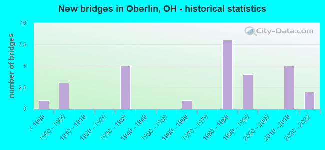
- New bridges - historical statistics
- 1Before 1900
- 31900-1909
- 51930-1939
- 11960-1969
- 81980-1989
- 41990-1999
- 52010-2019
- 22020-2022

- Reconstructed bridges - Historical Statistics
- 51970-1979
- 21980-1989
- 11990-1999


- Bridge Condition - Deck
- 32.0%Excellent
- 12.0%Very good
- 28.0%Good
- 16.0%Satisfactory
- 8.0%Fair
- 4.0%Poor

- Bridge Condition - Superstructure
- 24.0%Excellent
- 24.0%Very good
- 24.0%Good
- 16.0%Satisfactory
- 4.0%Fair
- 8.0%Poor

- Bridge Condition - Substructure
- 24.0%Excellent
- 20.0%Very good
- 16.0%Good
- 20.0%Satisfactory
- 20.0%Fair

- Bridge Condition - Channel
- 30.4%Excellent
- 4.3%Very good
- 34.8%Good
- 26.1%Satisfactory
- 4.3%Poor
Find on map >> Show street view
Structure Number: 4701909, Location: 2.12 MILES EAST OF SR 58 (Lat: 41.281819, Lng: -82.185261), Route carried "on" structure: County highway T0015, Year Built: 1987, Status: Open, Structure Length: 8.11m (26.61ft), Average Daily Traffic: 1,083 (year 2015), Truck Traffic: 1%, Average Future Daily Traffic: 19,404 (year 2035), Design Load: HS 20, Features Intersected: OVER LOR-20-0871, Facility Carried by Structure: T-15 PARSONS ROAD
Minimum Vertical Clearance: 30+ m (98+ ft), Kilometerpoint: 3.539, Lanes on structure: 2, Lanes under structure: 4, Owner: State Highway Agency, Approaching Roadway Width: 11.0m (36.1ft), Skew: 4 degrees, Material/Design: Steel continuous, Design/Construction: Stringer/Multi-beam, Number Of Spans In Main Unit: 4, Length of Maximum Span: 23.5m (77.1ft), Curb-To-Curb Width: 9.4m (30.8ft), Out-to-Out Width: 10.3m (33.8ft)
Condition: Deck: Good, Superstructure: Very good, Substructure: Very good, Operating Rating: 45.4 metric tons, Method Used To Determine Operating Rating: Load and Resistance Factor Rating (LRFR) rating reported by rating factor(RF) method using HL-93 loadings, Inventory Rating: 35.6 metric tons, Method Used To Determine Inventory Rating: Load and Resistance Factor Rating (LRFR) rating reported by rating factor(RF) method using HL-93 loadings, Structural Evaluation: Equal to present desirable criteria, Deck Geometry: Somewhat better than minimum adequacy, Underclear: High priority of corrective action, Approach Roadway Alignment: Equal to present desirable criteria, Designated Inspection Frequency: Every 24 months, Inspection Date: December 2021, Deck Structure Type: Concrete Cast-file-Place, Wearing Surface/Protective System: Wearing Surface: Monolithic Concrete, Deck Protection: Epoxy Coated Reinforcing
Find on map >> Show street view
Structure Number: 4701917, Location: 3.40 MILES EAST OF SR 58 (Lat: 41.294561, Lng: -82.166761), Route carried "on" structure: County highway C0169, Year Built: 1987, Status: Open, Structure Length: 8.72m (28.61ft), Average Daily Traffic: 351 (year 2015), Truck Traffic: 7%, Average Future Daily Traffic: 21,006 (year 2035), Design Load: HS 20, Features Intersected: OVER LOR-20-0999, Facility Carried by Structure: T-169 HALE ROAD
Minimum Vertical Clearance: 30+ m (98+ ft), Kilometerpoint: 0.000, Lanes on structure: 2, Lanes under structure: 5, Owner: State Highway Agency, Approaching Roadway Width: 9.8m (32.2ft), Skew: 3 degrees, Material/Design: Steel continuous, Design/Construction: Stringer/Multi-beam, Number Of Spans In Main Unit: 4, Length of Maximum Span: 30.8m (101.0ft), Curb-To-Curb Width: 8.2m (26.9ft), Out-to-Out Width: 9.1m (29.9ft)
Condition: Deck: Good, Superstructure: Very good, Substructure: Very good, Operating Rating: 61.6 metric tons, Method Used To Determine Operating Rating: Load Factor (LF) rating reported by rating factor (RF) method using MS18 loading, Inventory Rating: 35.6 metric tons, Method Used To Determine Inventory Rating: Load Factor (LF) rating reported by rating factor (RF) method using MS18 loading, Structural Evaluation: Equal to present desirable criteria, Deck Geometry: Somewhat better than minimum adequacy, Underclear: High priority of corrective action, Approach Roadway Alignment: Equal to present desirable criteria, Designated Inspection Frequency: Every 24 months, Inspection Date: December 2021, Deck Structure Type: Concrete Cast-file-Place, Wearing Surface/Protective System: Wearing Surface: Monolithic Concrete, Deck Protection: Epoxy Coated Reinforcing
Find on map >> Show street view
Structure Number: 4701933, Location: 3.97 MILES EAST OF SR 58 (Lat: 41.299539, Lng: -82.158211), Route carried "on" structure: US 20, Year Built: 1987, Status: Open, Structure Length: 2.47m (8.10ft), Average Daily Traffic: 7,567 (year 2015), Truck Traffic: 11%, Average Future Daily Traffic: 10,503 (year 2035), Design Load: HS 20+Mod, Features Intersected: OVER PLUM CREEK
Minimum Vertical Clearance: 30+ m (98+ ft), Kilometerpoint: 16.995, Lanes on structure: 2, Base Highway Network: Yes, Owner: State Highway Agency, Approaching Roadway Width: 13.4m (44.0ft), Material/Design: Concrete continuous, Design/Construction: Slab, Number Of Spans In Main Unit: 3, Length of Maximum Span: 9.1m (29.9ft), Curb-To-Curb Width: 12.2m (40.0ft), Out-to-Out Width: 12.2m (40.0ft)
Condition: Deck: Good, Superstructure: Good, Substructure: Satisfactory, Channel: Good, Operating Rating: 97.2 metric tons, Method Used To Determine Operating Rating: Load Factor (LF) rating reported by rating factor (RF) method using MS18 loading, Inventory Rating: 64.8 metric tons, Method Used To Determine Inventory Rating: Load Factor (LF) rating reported by rating factor (RF) method using MS18 loading, Structural Evaluation: Equal to present minimum criteria, Deck Geometry: Better than present minimum criteria, Waterway Adequacy: Equal to present desirable criteria, Approach Roadway Alignment: Equal to present desirable criteria, Designated Inspection Frequency: Every 12 months, Inspection Date: November 2021, Deck Structure Type: Concrete Cast-file-Place, Wearing Surface/Protective System: Wearing Surface: Bituminous, Deck Protection: Epoxy Coated Reinforcing
Find on map >> Show street view
Structure Number: 4701941, Location: 3.97 MILES EAST OF SR 58 (Lat: 41.299389, Lng: -82.158061), Route carried "on" structure: US 20, Year Built: 1987, Status: Open, Structure Length: 2.47m (8.10ft), Average Daily Traffic: 7,567 (year 2015), Truck Traffic: 11%, Average Future Daily Traffic: 10,503 (year 2035), Design Load: HS 20+Mod, Features Intersected: OVER PLUM CREEK
Minimum Vertical Clearance: 30+ m (98+ ft), Kilometerpoint: 16.995, Lanes on structure: 2, Base Highway Network: Yes, Owner: State Highway Agency, Approaching Roadway Width: 13.4m (44.0ft), Material/Design: Concrete continuous, Design/Construction: Slab, Number Of Spans In Main Unit: 3, Length of Maximum Span: 9.1m (29.9ft), Curb-To-Curb Width: 12.2m (40.0ft), Out-to-Out Width: 12.2m (40.0ft)
Condition: Deck: Good, Superstructure: Good, Substructure: Satisfactory, Channel: Satisfactory, Operating Rating: 97.2 metric tons, Method Used To Determine Operating Rating: Load Factor (LF) rating reported by rating factor (RF) method using MS18 loading, Inventory Rating: 64.8 metric tons, Method Used To Determine Inventory Rating: Load Factor (LF) rating reported by rating factor (RF) method using MS18 loading, Structural Evaluation: Equal to present minimum criteria, Deck Geometry: Better than present minimum criteria, Waterway Adequacy: Equal to present desirable criteria, Approach Roadway Alignment: Equal to present desirable criteria, Designated Inspection Frequency: Every 12 months, Inspection Date: November 2021, Deck Structure Type: Concrete Cast-file-Place, Wearing Surface/Protective System: Wearing Surface: Bituminous, Deck Protection: Epoxy Coated Reinforcing
Find on map >> Show street view
Structure Number: 4703278, Location: 1.61 MILES NORTH OF US 20 (Lat: 41.288750, Lng: -82.217519), Route carried "on" structure: State highway 58, Year Built: 1883, Status: Open, Structure Length: 0.76m (2.49ft), Average Daily Traffic: 7,627 (year 2015), Truck Traffic: 8%, Average Future Daily Traffic: 10,586 (year 2035), Design Load: HS 20+Mod, Features Intersected: PLUM CREEK
Minimum Vertical Clearance: 30+ m (98+ ft), Kilometerpoint: 25.138, Lanes on structure: 2, Base Highway Network: Yes, Owner: State Highway Agency, Approaching Roadway Width: 10.1m (33.1ft), Material/Design: Masonry, Design/Construction: Culvert, Number Of Spans In Main Unit: 1, Length of Maximum Span: 6.1m (20.0ft), Curb or Sidewalk Widths: Left: 1.5m (4.9ft), Right: 1.6m (5.2ft)
Condition: Channel: Satisfactory, Culverts: Fair, Operating Rating: 29.2 metric tons, Method Used To Determine Operating Rating: Load Factor (LF) rating reported by rating factor (RF) method using MS18 loading, Inventory Rating: 16.2 metric tons, Method Used To Determine Inventory Rating: Load Factor (LF) rating reported by rating factor (RF) method using MS18 loading, Structural Evaluation: Meets minimum limits, Waterway Adequacy: Equal to present desirable criteria, Approach Roadway Alignment: Equal to present desirable criteria, Designated Inspection Frequency: Every 12 months, Inspection Date: December 2021, Wearing Surface/Protective System: Wearing Surface: Bituminous
Find on map >> Show street view
Structure Number: 4706994, Location: 1.03 MILES EAST OF SR 58 (Lat: 41.237231, Lng: -82.198719), Route carried "on" structure: State highway 303, Year Built: 1967, Status: Open, Structure Length: 4.05m (13.29ft), Average Daily Traffic: 2,794 (year 2015), Truck Traffic: 11%, Average Future Daily Traffic: 3,878 (year 2035), Design Load: HS 20, Features Intersected: WEST BR BLACK RIVER
Minimum Vertical Clearance: 30+ m (98+ ft), Kilometerpoint: 11.957, Lanes on structure: 2, Owner: State Highway Agency, Approaching Roadway Width: 7.3m (24.0ft), Material/Design: Steel continuous, Design/Construction: Stringer/Multi-beam, Number Of Spans In Main Unit: 3, Length of Maximum Span: 14.6m (47.9ft), Curb-To-Curb Width: 11.0m (36.1ft), Out-to-Out Width: 11.0m (36.1ft)
Condition: Deck: Good, Superstructure: Good, Substructure: Satisfactory, Channel: Good, Operating Rating: 48.6 metric tons, Method Used To Determine Operating Rating: Load Factor (LF) rating reported by rating factor (RF) method using MS18 loading, Inventory Rating: 29.2 metric tons, Method Used To Determine Inventory Rating: Load Factor (LF) rating reported by rating factor (RF) method using MS18 loading, Structural Evaluation: Equal to present minimum criteria, Deck Geometry: Somewhat better than minimum adequacy, Waterway Adequacy: Equal to present desirable criteria, Approach Roadway Alignment: Equal to present minimum criteria, Designated Inspection Frequency: Every 12 months, Inspection Date: August 2021, Deck Structure Type: Concrete Cast-file-Place, Wearing Surface/Protective System: Wearing Surface: Integral Concrete
Find on map >> Show street view
Structure Number: 4707362, Location: .74 MI SOUTH OF US 20 (Lat: 41.293900, Lng: -82.186511), Route carried "on" structure: State highway 511, Year Built: 1995, Status: Open, Structure Length: 1.46m (4.79ft), Average Daily Traffic: 5,151 (year 2015), Truck Traffic: 6%, Average Future Daily Traffic: 7,150 (year 2035), Design Load: HS 20+Mod, Features Intersected: PLUM CREEK
Minimum Vertical Clearance: 30+ m (98+ ft), Kilometerpoint: 34.488, Lanes on structure: 2, Owner: State Highway Agency, Approaching Roadway Width: 7.3m (24.0ft), Material/Design: Prestressed concrete, Design/Construction: Box Beam or Girders - Multiple, Number Of Spans In Main Unit: 1, Length of Maximum Span: 14.3m (46.9ft), Curb-To-Curb Width: 12.2m (40.0ft), Out-to-Out Width: 12.2m (40.0ft)
Condition: Deck: Very good, Superstructure: Very good, Substructure: Very good, Channel: Satisfactory, Operating Rating: 42.1 metric tons, Method Used To Determine Operating Rating: Load Factor (LF) rating reported by rating factor (RF) method using MS18 loading, Inventory Rating: 32.4 metric tons, Method Used To Determine Inventory Rating: Load Factor (LF) rating reported by rating factor (RF) method using MS18 loading, Structural Evaluation: Equal to present desirable criteria, Deck Geometry: Somewhat better than minimum adequacy, Waterway Adequacy: Equal to present desirable criteria, Approach Roadway Alignment: Superior to present desirable criteria, Designated Inspection Frequency: Every 24 months, Inspection Date: July 2021, Deck Structure Type: Concrete Cast-file-Place, Wearing Surface/Protective System: Wearing Surface: Bituminous
Find on map >> Show street view
Structure Number: 470737, Location: 2.36 MILES EAST OF SR 58 (Lat: 41.292419, Lng: -82.170889), Route carried "on" structure: Ramp State highway 511, Year Built: 1987, Status: Open, Structure Length: 6.61m (21.69ft), Average Daily Traffic: 6,630 (year 2011), Truck Traffic: 12%, Average Future Daily Traffic: 9,202 (year 2031), Design Load: HS 20, Features Intersected: OVER LOR-20-0973 (RAMP)
Minimum Vertical Clearance: 30+ m (98+ ft), Kilometerpoint: 35.679, Lanes on structure: 2, Lanes under structure: 5, Owner: State Highway Agency, Approaching Roadway Width: 15.9m (52.2ft), Skew: 20 degrees, Material/Design: Steel continuous, Design/Construction: Stringer/Multi-beam, Number Of Spans In Main Unit: 4, Length of Maximum Span: 21.0m (68.9ft), Curb-To-Curb Width: 15.8m (51.8ft), Out-to-Out Width: 16.7m (54.8ft)
Condition: Deck: Very good, Superstructure: Very good, Substructure: Very good, Operating Rating: 55.1 metric tons, Method Used To Determine Operating Rating: Load and Resistance Factor Rating (LRFR) rating reported by rating factor(RF) method using HL-93 loadings, Inventory Rating: 42.1 metric tons, Method Used To Determine Inventory Rating: Load and Resistance Factor Rating (LRFR) rating reported by rating factor(RF) method using HL-93 loadings, Structural Evaluation: Equal to present desirable criteria, Deck Geometry: Superior to present desirable criteria, Underclear: Meets minimum limits, Approach Roadway Alignment: Equal to present desirable criteria, Designated Inspection Frequency: Every 24 months, Inspection Date: July 2021, Deck Structure Type: Concrete Cast-file-Place, Wearing Surface/Protective System: Wearing Surface: Monolithic Concrete, Deck Protection: Epoxy Coated Reinforcing
Find on map >> Show street view
Structure Number: 4730005, Location: 0.14 MI North of Hamilton (Lat: 41.281831, Lng: -82.238819), Route carried "on" structure: County highway T0016, Year Built: 2014, Status: Open, Structure Length: 0.91m (2.99ft), Average Daily Traffic: 4,731 (year 2015), Truck Traffic: 5%, Average Future Daily Traffic: 6,567 (year 2035), Design Load: HL 93, Features Intersected: Plum Creek, Facility Carried by Structure: Pyle S Amhsrst R
Minimum Vertical Clearance: 30+ m (98+ ft), Kilometerpoint: 0.225, Lanes on structure: 2, Owner: County Highway Agency, Approaching Roadway Width: 6.1m (20.0ft), Material/Design: Concrete, Design/Construction: Frame, Number Of Spans In Main Unit: 1, Length of Maximum Span: 7.9m (25.9ft), Curb-To-Curb Width: 9.1m (29.9ft), Out-to-Out Width: 9.1m (29.9ft)
Condition: Deck: Excellent, Superstructure: Excellent, Substructure: Excellent, Channel: Excellent, Operating Rating: 45.4 metric tons, Method Used To Determine Operating Rating: Load and Resistance Factor Rating (LRFR) rating reported by rating factor(RF) method using HL-93 loadings, Inventory Rating: 35.6 metric tons, Method Used To Determine Inventory Rating: Load and Resistance Factor Rating (LRFR) rating reported by rating factor(RF) method using HL-93 loadings, Structural Evaluation: Superior to present desirable criteria, Deck Geometry: Meets minimum limits, Waterway Adequacy: Superior to present desirable criteria, Approach Roadway Alignment: Equal to present desirable criteria, Designated Inspection Frequency: Every 24 months, Inspection Date: November 2021, Deck Structure Type: Concrete Cast-file-Place, Wearing Surface/Protective System: Wearing Surface: Bituminous
Find on map >> Show street view
Structure Number: 4736087, Location: .04MI.NORTH OF (Lat: 41.251781, Lng: -82.208481), Route carried "on" structure: County highway C0075, Year Built: 1900, Year Reconstructed: 1983, Status: Open, Structure Length: 0.79m (2.59ft), Average Daily Traffic: 548 (year 2015), Truck Traffic: 7%, Average Future Daily Traffic: 761 (year 2035), Design Load: HS 20+Mod, Features Intersected: DITCH HALLAUER RD., Facility Carried by Structure: HALLAUER RD.
Minimum Vertical Clearance: 30+ m (98+ ft), Kilometerpoint: 2.849, Lanes on structure: 2, Owner: County Highway Agency, Approaching Roadway Width: 9.8m (32.2ft), Skew: 2 degrees, Material/Design: Prestressed concrete, Design/Construction: Box Beam or Girders - Multiple, Number Of Spans In Main Unit: 1, Length of Maximum Span: 7.0m (23.0ft), Curb-To-Curb Width: 7.3m (24.0ft), Out-to-Out Width: 7.3m (24.0ft)
Condition: Deck: Good, Superstructure: Good, Substructure: Fair, Channel: Good, Operating Rating: 42.1 metric tons, Method Used To Determine Operating Rating: Load Factor (LF) rating reported by rating factor (RF) method using MS18 loading, Inventory Rating: 32.4 metric tons, Method Used To Determine Inventory Rating: Load Factor (LF) rating reported by rating factor (RF) method using MS18 loading, Structural Evaluation: Somewhat better than minimum adequacy, Deck Geometry: Meets minimum limits, Waterway Adequacy: Somewhat better than minimum adequacy, Approach Roadway Alignment: Equal to present desirable criteria, Designated Inspection Frequency: Every 12 months, Inspection Date: November 2021, Deck Structure Type: Concrete Cast-file-Place, Wearing Surface/Protective System: Wearing Surface: Bituminous
Find on map >> Show street view
Structure Number: 4736109, Location: .51MI.SOUTH OF (Lat: 41.259561, Lng: -82.208081), Route carried "on" structure: County highway C0075, Year Built: 1900, Year Reconstructed: 1983, Status: Open, Structure Length: 0.76m (2.49ft), Average Daily Traffic: 548 (year 2015), Truck Traffic: 7%, Average Future Daily Traffic: 761 (year 2035), Design Load: HS 20+Mod, Features Intersected: BARBER DITCH HALLAUER RD, Facility Carried by Structure: HALLAUER RD.
Minimum Vertical Clearance: 30+ m (98+ ft), Kilometerpoint: 3.701, Lanes on structure: 2, Owner: County Highway Agency, Approaching Roadway Width: 9.8m (32.2ft), Skew: 1 degrees, Material/Design: Prestressed concrete, Design/Construction: Box Beam or Girders - Multiple, Number Of Spans In Main Unit: 1, Length of Maximum Span: 6.7m (22.0ft), Curb-To-Curb Width: 9.7m (31.8ft), Out-to-Out Width: 9.8m (32.2ft)
Condition: Deck: Satisfactory, Superstructure: Satisfactory, Substructure: Satisfactory, Channel: Good, Operating Rating: 42.1 metric tons, Method Used To Determine Operating Rating: Load Factor (LF) rating reported by rating factor (RF) method using MS18 loading, Inventory Rating: 32.4 metric tons, Method Used To Determine Inventory Rating: Load Factor (LF) rating reported by rating factor (RF) method using MS18 loading, Structural Evaluation: Equal to present minimum criteria, Deck Geometry: Equal to present minimum criteria, Waterway Adequacy: Better than present minimum criteria, Approach Roadway Alignment: Equal to present desirable criteria, Designated Inspection Frequency: Every 12 months, Inspection Date: November 2021, Deck Structure Type: Concrete Cast-file-Place, Wearing Surface/Protective System: Wearing Surface: Bituminous
Find on map >> Show street view
Structure Number: 4736193, Location: 0.71 MI EAST OF QUARRY RD (Lat: 41.279669, Lng: -82.245650), Route carried "on" structure: County highway T0122, Year Built: 2015, Status: Open, Structure Length: 0.91m (2.99ft), Average Daily Traffic: 700 (year 2015), Truck Traffic: 1%, Average Future Daily Traffic: 972 (year 2035), Design Load: HL 93, Features Intersected: PLUM CREEK HAMILTON ST., Facility Carried by Structure: TWP RD 122 HAMILTN
Minimum Vertical Clearance: 30+ m (98+ ft), Kilometerpoint: 1.143, Lanes on structure: 2, Owner: County Highway Agency, Approaching Roadway Width: 6.7m (22.0ft), Material/Design: Concrete, Design/Construction: Frame, Number Of Spans In Main Unit: 1, Length of Maximum Span: 7.9m (25.9ft), Curb-To-Curb Width: 8.5m (27.9ft), Out-to-Out Width: 8.5m (27.9ft)
Condition: Deck: Excellent, Superstructure: Excellent, Substructure: Excellent, Channel: Excellent, Operating Rating: 45.4 metric tons, Method Used To Determine Operating Rating: Load and Resistance Factor Rating (LRFR) rating reported by rating factor(RF) method using HL-93 loadings, Inventory Rating: 35.6 metric tons, Method Used To Determine Inventory Rating: Load and Resistance Factor Rating (LRFR) rating reported by rating factor(RF) method using HL-93 loadings, Structural Evaluation: Superior to present desirable criteria, Deck Geometry: Somewhat better than minimum adequacy, Waterway Adequacy: Superior to present desirable criteria, Approach Roadway Alignment: Equal to present desirable criteria, Designated Inspection Frequency: Every 24 months, Inspection Date: November 2021, Deck Structure Type: Concrete Cast-file-Place, Wearing Surface/Protective System: Wearing Surface: Bituminous, Membrane: Preformed Fabric, Deck Protection: Epoxy Coated Reinforcing
Find on map >> Show street view
Structure Number: 4736398, Location: 0.07 miles west of Hawley (Lat: 41.251150, Lng: -82.189169), Route carried "on" structure: County highway T0073, Year Built: 2016, Status: Open, Structure Length: 3.44m (11.29ft), Average Daily Traffic: 180 (year 2015), Truck Traffic: 3%, Average Future Daily Traffic: 220 (year 2035), Design Load: HL 93, Features Intersected: W.B. of the Black River, Facility Carried by Structure: Hughes Rd
Minimum Vertical Clearance: 30+ m (98+ ft), Kilometerpoint: 5.697, Lanes on structure: 2, Owner: County Highway Agency, Approaching Roadway Width: 6.1m (20.0ft), Material/Design: Prestressed concrete, Design/Construction: Box Beam or Girders - Multiple, Number Of Spans In Main Unit: 1, Length of Maximum Span: 32.6m (107.0ft), Curb-To-Curb Width: 8.5m (27.9ft), Out-to-Out Width: 8.5m (27.9ft)
Condition: Deck: Excellent, Superstructure: Excellent, Substructure: Excellent, Channel: Good, Operating Rating: 64.8 metric tons, Method Used To Determine Operating Rating: Load and Resistance Factor Rating (LRFR) rating reported by rating factor(RF) method using HL-93 loadings, Inventory Rating: 48.6 metric tons, Method Used To Determine Inventory Rating: Load and Resistance Factor Rating (LRFR) rating reported by rating factor(RF) method using HL-93 loadings, Structural Evaluation: Superior to present desirable criteria, Deck Geometry: Equal to present minimum criteria, Waterway Adequacy: Superior to present desirable criteria, Approach Roadway Alignment: Better than present minimum criteria, Designated Inspection Frequency: Every 24 months, Inspection Date: October 2021, Deck Structure Type: Concrete Cast-file-Place, Wearing Surface/Protective System: Wearing Surface: Monolithic Concrete, Membrane: Epoxy
Find on map >> Show street view
Structure Number: 4737075, Location: .01MI.WEST OF WEST (Lat: 41.265169, Lng: -82.179650), Route carried "on" structure: County highway T0052, Year Built: 1994, Status: Open, Structure Length: 3.17m (10.40ft), Average Daily Traffic: 324 (year 2015), Truck Traffic: 7%, Average Future Daily Traffic: 450 (year 2035), Design Load: HS 20, Features Intersected: W.B.BLACK RV K.N.PLATE, Facility Carried by Structure: KIPTON NICKLE PL.
Minimum Vertical Clearance: 30+ m (98+ ft), Kilometerpoint: 4.345, Lanes on structure: 2, Owner: County Highway Agency, Approaching Roadway Width: 7.9m (25.9ft), Skew: 1 degrees, Material/Design: Prestressed concrete, Design/Construction: Box Beam or Girders - Multiple, Number Of Spans In Main Unit: 3, Length of Maximum Span: 10.4m (34.1ft), Curb-To-Curb Width: 11.0m (36.1ft), Out-to-Out Width: 11.0m (36.1ft)
Condition: Deck: Excellent, Superstructure: Good, Substructure: Good, Channel: Satisfactory, Operating Rating: 42.1 metric tons, Method Used To Determine Operating Rating: Load Factor (LF) rating reported by rating factor (RF) method using MS18 loading, Inventory Rating: 32.4 metric tons, Method Used To Determine Inventory Rating: Load Factor (LF) rating reported by rating factor (RF) method using MS18 loading, Structural Evaluation: Better than present minimum criteria, Deck Geometry: Equal to present desirable criteria, Waterway Adequacy: Equal to present desirable criteria, Approach Roadway Alignment: Equal to present desirable criteria, Designated Inspection Frequency: Every 24 months, Inspection Date: November 2021, Deck Structure Type: Concrete Cast-file-Place, Wearing Surface/Protective System: Wearing Surface: Bituminous, Membrane: Built-up
Find on map >> Show street view
Structure Number: 4737091, Location: 0.6 MI EAST OF (Lat: 41.265219, Lng: -82.168281), Route carried "on" structure: County highway T0052, Year Built: 1994, Status: Open, Structure Length: 2.99m (9.81ft), Average Daily Traffic: 324 (year 2015), Truck Traffic: 7%, Average Future Daily Traffic: 450 (year 2035), Design Load: HS 20, Features Intersected: WELLINGTON CR K.N.PLATE, Facility Carried by Structure: KIPTON NICKLE PL.
Minimum Vertical Clearance: 30+ m (98+ ft), Kilometerpoint: 5.311, Lanes on structure: 2, Owner: County Highway Agency, Approaching Roadway Width: 4.9m (16.1ft), Skew: 3 degrees, Material/Design: Prestressed concrete, Design/Construction: Box Beam or Girders - Multiple, Number Of Spans In Main Unit: 3, Length of Maximum Span: 9.8m (32.2ft), Curb-To-Curb Width: 8.5m (27.9ft), Out-to-Out Width: 8.5m (27.9ft)
Condition: Deck: Satisfactory, Superstructure: Satisfactory, Substructure: Good, Channel: Excellent, Operating Rating: 42.1 metric tons, Method Used To Determine Operating Rating: Load Factor (LF) rating reported by rating factor (RF) method using MS18 loading, Inventory Rating: 32.4 metric tons, Method Used To Determine Inventory Rating: Load Factor (LF) rating reported by rating factor (RF) method using MS18 loading, Structural Evaluation: Equal to present minimum criteria, Deck Geometry: Equal to present minimum criteria, Waterway Adequacy: Equal to present desirable criteria, Approach Roadway Alignment: Equal to present desirable criteria, Designated Inspection Frequency: Every 12 months, Inspection Date: November 2021, Deck Structure Type: Concrete Cast-file-Place, Wearing Surface/Protective System: Wearing Surface: Bituminous, Membrane: Built-up
Find on map >> Show street view
Structure Number: 4738128, Location: .14 MI. S.OF COLLEGE ST. (Lat: 41.289550, Lng: -82.197369), Route carried "on" structure: County highway M0039, Year Built: 2012, Status: Open, Structure Length: 1.22m (4.00ft), Average Daily Traffic: 983 (year 2015), Truck Traffic: 5%, Average Future Daily Traffic: 1,364 (year 2035), Design Load: HL 93, Features Intersected: PLUM CREEK OBERLIN ROAD, Facility Carried by Structure: OBERLIN ROAD
Minimum Vertical Clearance: 30+ m (98+ ft), Kilometerpoint: 0.708, Lanes on structure: 2, Owner: County Highway Agency, Approaching Roadway Width: 6.1m (20.0ft), Material/Design: Prestressed concrete, Design/Construction: Box Beam or Girders - Multiple, Number Of Spans In Main Unit: 1, Length of Maximum Span: 11.3m (37.1ft), Curb-To-Curb Width: 8.5m (27.9ft), Out-to-Out Width: 8.5m (27.9ft)
Condition: Deck: Excellent, Superstructure: Excellent, Substructure: Excellent, Channel: Excellent, Operating Rating: 68.0 metric tons, Method Used To Determine Operating Rating: Load and Resistance Factor Rating (LRFR) rating reported by rating factor(RF) method using HL-93 loadings, Inventory Rating: 51.8 metric tons, Method Used To Determine Inventory Rating: Load and Resistance Factor Rating (LRFR) rating reported by rating factor(RF) method using HL-93 loadings, Structural Evaluation: Superior to present desirable criteria, Deck Geometry: Somewhat better than minimum adequacy, Waterway Adequacy: Superior to present desirable criteria, Approach Roadway Alignment: Equal to present desirable criteria, Designated Inspection Frequency: Every 24 months, Inspection Date: November 2021, Deck Structure Type: Concrete Cast-file-Place, Wearing Surface/Protective System: Wearing Surface: Bituminous, Membrane: Preformed Fabric, Deck Protection: Other
Find on map >> Show street view
Structure Number: 4739345, Location: .83MI.NORTH OF SR (Lat: 41.306550, Lng: -82.258050), Route carried "on" structure: County highway C0030, Year Built: 1900, Year Reconstructed: 1987, Status: Open, Structure Length: 0.70m (2.30ft), Average Daily Traffic: 841 (year 2015), Truck Traffic: 7%, Average Future Daily Traffic: 1,167 (year 2035), Design Load: HS 20+Mod, Features Intersected: BEAVER CR QUARRY RD., Facility Carried by Structure: QUARRY RD.
Minimum Vertical Clearance: 30+ m (98+ ft), Kilometerpoint: 27.214, Lanes on structure: 2, Owner: County Highway Agency, Approaching Roadway Width: 10.1m (33.1ft), Material/Design: Prestressed concrete, Design/Construction: Box Beam or Girders - Multiple, Number Of Spans In Main Unit: 1, Length of Maximum Span: 6.1m (20.0ft), Curb-To-Curb Width: 7.4m (24.3ft), Out-to-Out Width: 7.4m (24.3ft)
Condition: Deck: Satisfactory, Superstructure: Satisfactory, Substructure: Satisfactory, Channel: Good, Operating Rating: 42.1 metric tons, Method Used To Determine Operating Rating: Load Factor (LF) rating reported by rating factor (RF) method using MS18 loading, Inventory Rating: 32.4 metric tons, Method Used To Determine Inventory Rating: Load Factor (LF) rating reported by rating factor (RF) method using MS18 loading, Structural Evaluation: Equal to present minimum criteria, Deck Geometry: Meets minimum limits, Waterway Adequacy: Equal to present desirable criteria, Approach Roadway Alignment: Equal to present desirable criteria, Designated Inspection Frequency: Every 12 months, Inspection Date: November 2021, Deck Structure Type: Concrete Cast-file-Place, Wearing Surface/Protective System: Wearing Surface: Bituminous
Find on map >> Show street view
Structure Number: 4741006, Location: .23 mi north of K.N Plate (Lat: 41.268600, Lng: -82.179300), Route carried "on" structure: County highway 38, Year Built: 2020, Status: Open, Structure Length: 0.78m (2.56ft), Average Daily Traffic: 600 (year 2020), Truck Traffic: 5%, Average Future Daily Traffic: 800 (year 2040), Design Load: HL 93, Features Intersected: Tributary to Black River, Facility Carried by Structure: West Rd
Minimum Vertical Clearance: 30+ m (98+ ft), Kilometerpoint: 22.965, Lanes on structure: 2, Owner: County Highway Agency, Approaching Roadway Width: 6.1m (20.0ft), Material/Design: Concrete, Design/Construction: Slab, Number Of Spans In Main Unit: 1, Length of Maximum Span: 6.4m (21.0ft), Curb-To-Curb Width: 8.5m (27.9ft), Out-to-Out Width: 8.5m (27.9ft)
Condition: Deck: Excellent, Superstructure: Excellent, Substructure: Excellent, Channel: Excellent, Operating Rating: 97.2 metric tons, Method Used To Determine Operating Rating: Load and Resistance Factor Rating (LRFR) rating reported by rating factor(RF) method using HL-93 loadings, Inventory Rating: 74.5 metric tons, Method Used To Determine Inventory Rating: Load and Resistance Factor Rating (LRFR) rating reported by rating factor(RF) method using HL-93 loadings, Structural Evaluation: Superior to present desirable criteria, Deck Geometry: Somewhat better than minimum adequacy, Waterway Adequacy: Superior to present desirable criteria, Approach Roadway Alignment: Superior to present desirable criteria, Designated Inspection Frequency: Every 12 months, Inspection Date: November 2021, Deck Structure Type: Concrete Cast-file-Place, Wearing Surface/Protective System: Wearing Surface: Bituminous, Membrane: Other, Deck Protection: Epoxy Coated Reinforcing
Find on map >> Show street view
Structure Number: 4741235, Location: .93 mi east of SR 58 (Lat: 41.223619, Lng: -82.201131), Route carried "on" structure: Other road TR72, Year Built: 2020, Status: Open, Structure Length: 3.12m (10.24ft), Average Daily Traffic: 180 (year 2018), Truck Traffic: 3%, Average Future Daily Traffic: 210 (year 2038), Design Load: HL 93, Features Intersected: West Branch Black River, Facility Carried by Structure: Whitney Rd
Minimum Vertical Clearance: 30+ m (98+ ft), Kilometerpoint: 4.683, Lanes on structure: 2, Owner: County Highway Agency, Approaching Roadway Width: 6.1m (20.0ft), Skew: 3 degrees, Material/Design: Concrete, Design/Construction: Box Beam or Girders - Single/Spread, Number Of Spans In Main Unit: 1, Number Of Approach Spans: 2, Length of Maximum Span: 30.2m (99.1ft), Curb-To-Curb Width: 8.5m (27.9ft), Out-to-Out Width: 8.5m (27.9ft)
Condition: Deck: Excellent, Superstructure: Excellent, Substructure: Excellent, Channel: Excellent, Operating Rating: 61.6 metric tons, Method Used To Determine Operating Rating: Load and Resistance Factor Rating (LRFR) rating reported by rating factor(RF) method using HL-93 loadings, Inventory Rating: 35.6 metric tons, Method Used To Determine Inventory Rating: Load and Resistance Factor Rating (LRFR) rating reported by rating factor(RF) method using HL-93 loadings, Structural Evaluation: Superior to present desirable criteria, Deck Geometry: Equal to present minimum criteria, Waterway Adequacy: Equal to present desirable criteria, Approach Roadway Alignment: Equal to present minimum criteria, Designated Inspection Frequency: Every 12 months, Inspection Date: October 2021, Deck Structure Type: Concrete Cast-file-Place, Wearing Surface/Protective System: Wearing Surface: Monolithic Concrete, Membrane: Other, Deck Protection: Epoxy Coated Reinforcing
Find on map >> Show street view
Structure Number: 4741366, Location: 1.95 MI. E. OF (Lat: 41.300769, Lng: -82.159719), Route carried "on" structure: County highway C0231, Year Built: 1992, Status: Open, Structure Length: 2.10m (6.89ft), Average Daily Traffic: 4,658 (year 2015), Truck Traffic: 7%, Average Future Daily Traffic: 6,465 (year 2035), Design Load: HS 20+Mod, Features Intersected: PLUM CR/OBERLIN ELYRIA, Facility Carried by Structure: OBERLIN ELYRIA RD
Minimum Vertical Clearance: 30+ m (98+ ft), Kilometerpoint: 3.138, Lanes on structure: 2, Owner: County Highway Agency, Approaching Roadway Width: 10.4m (34.1ft), Material/Design: Prestressed concrete, Design/Construction: Box Beam or Girders - Multiple, Number Of Spans In Main Unit: 1, Length of Maximum Span: 19.8m (65.0ft), Curb-To-Curb Width: 10.4m (34.1ft), Out-to-Out Width: 10.4m (34.1ft)
Condition: Deck: Excellent, Superstructure: Very good, Substructure: Very good, Channel: Excellent, Operating Rating: 42.1 metric tons, Method Used To Determine Operating Rating: Load Factor (LF) rating reported by rating factor (RF) method using MS18 loading, Inventory Rating: 32.4 metric tons, Method Used To Determine Inventory Rating: Load Factor (LF) rating reported by rating factor (RF) method using MS18 loading, Structural Evaluation: Equal to present desirable criteria, Deck Geometry: Somewhat better than minimum adequacy, Waterway Adequacy: Equal to present desirable criteria, Approach Roadway Alignment: Equal to present desirable criteria, Designated Inspection Frequency: Every 24 months, Inspection Date: November 2021, Deck Structure Type: Concrete Cast-file-Place, Wearing Surface/Protective System: Wearing Surface: Bituminous, Membrane: Built-up
Find on map >> Show street view
Structure Number: 4776348, Location: 0.1 MI W OF PROFESSOR ST. (Lat: 41.287000, Lng: -82.220500), Route carried "on" structure: City street 6, Year Built: 1930, Year Reconstructed: 1970, Status: Open, Structure Length: 0.85m (2.79ft), Average Daily Traffic: 1,334 (year 2019), Truck Traffic: 5%, Average Future Daily Traffic: 1,852 (year 2039), Design Load: HS 20+Mod, Features Intersected: PLUM CREEK, Facility Carried by Structure: Morgan Street
Minimum Vertical Clearance: 30+ m (98+ ft), Kilometerpoint: 1.609, Lanes on structure: 2, Owner: City or Municipal Highway Agency, Approaching Roadway Width: 6.1m (20.0ft), Material/Design: Prestressed concrete, Design/Construction: Box Beam or Girders - Multiple, Number Of Spans In Main Unit: 1, Length of Maximum Span: 7.6m (24.9ft), Curb or Sidewalk Widths: Left: 1.5m (4.9ft), Right: 1.5m (4.9ft), Curb-To-Curb Width: 6.1m (20.0ft), Out-to-Out Width: 14.6m (47.9ft)
Condition: Deck: Fair, Superstructure: Fair, Substructure: Fair, Channel: Satisfactory, Operating Rating: 68.0 metric tons, Method Used To Determine Operating Rating: Load Factor (LF) rating reported by rating factor (RF) method using MS18 loading, Inventory Rating: 38.9 metric tons, Method Used To Determine Inventory Rating: Load Factor (LF) rating reported by rating factor (RF) method using MS18 loading, Structural Evaluation: Somewhat better than minimum adequacy, Deck Geometry: High priority of replacement, Waterway Adequacy: Equal to present desirable criteria, Approach Roadway Alignment: Equal to present desirable criteria, Designated Inspection Frequency: Every 12 months, Inspection Date: November 2021, Deck Structure Type: Other, Wearing Surface/Protective System: Wearing Surface: Bituminous
Find on map >> Show street view
Structure Number: 4776402, Location: PARK ST AT PLUM CREEK (Lat: 41.290189, Lng: -82.212469), Route carried "on" structure: City street M0002, Year Built: 2012, Status: Open, Structure Length: 0.82m (2.69ft), Average Daily Traffic: 1,122 (year 2019), Truck Traffic: 2%, Average Future Daily Traffic: 1,557 (year 2039), Design Load: HL 93, Features Intersected: PLUM CREEK, Facility Carried by Structure: PARK STREET
Minimum Vertical Clearance: 30+ m (98+ ft), Kilometerpoint: 0.644, Lanes on structure: 2, Owner: City or Municipal Highway Agency, Approaching Roadway Width: 5.5m (18.0ft), Material/Design: Concrete, Design/Construction: Frame, Number Of Spans In Main Unit: 1, Length of Maximum Span: 7.6m (24.9ft), Curb or Sidewalk Widths: Left: 1.5m (4.9ft), Right: 2.2m (7.2ft), Curb-To-Curb Width: 6.4m (21.0ft), Out-to-Out Width: 11.3m (37.1ft)
Condition: Deck: Good, Superstructure: Good, Substructure: Good, Channel: Very good, Operating Rating: 55.1 metric tons, Method Used To Determine Operating Rating: Load and Resistance Factor Rating (LRFR) rating reported by rating factor(RF) method using HL-93 loadings, Inventory Rating: 42.1 metric tons, Method Used To Determine Inventory Rating: Load and Resistance Factor Rating (LRFR) rating reported by rating factor(RF) method using HL-93 loadings, Structural Evaluation: Better than present minimum criteria, Deck Geometry: High priority of replacement, Waterway Adequacy: Superior to present desirable criteria, Approach Roadway Alignment: Equal to present desirable criteria, Designated Inspection Frequency: Every 24 months, Inspection Date: November 2021, Deck Structure Type: Concrete Cast-file-Place, Wearing Surface/Protective System: Wearing Surface: Bituminous, Deck Protection: Epoxy Coated Reinforcing
Find on map >> Show street view
Structure Number: 4776445, Location: 0.70 MI N OF HAMILTON ST. (Lat: 41.289811, Lng: -82.214961), Route carried "on" structure: City street M0003, Year Built: 1930, Year Reconstructed: 1970, Status: Posted for load, Structure Length: 0.98m (3.22ft), Average Daily Traffic: 800 (year 1951), Truck Traffic: 5%, Average Future Daily Traffic: 1,110 (year 1971), Design Load: HS 15, Features Intersected: OVER PLUM CREEK, Facility Carried by Structure: PLEASANT STREET
Minimum Vertical Clearance: 30+ m (98+ ft), Kilometerpoint: 1.159, Lanes on structure: 2, Owner: City or Municipal Highway Agency, Approaching Roadway Width: 8.2m (26.9ft), Skew: 6 degrees, Material/Design: Prestressed concrete, Design/Construction: Box Beam or Girders - Multiple, Number Of Spans In Main Unit: 1, Length of Maximum Span: 7.6m (24.9ft), Curb or Sidewalk Widths: Left: 1.8m (5.9ft), Right: 0.0m, Curb-To-Curb Width: 8.7m (28.5ft), Out-to-Out Width: 10.9m (35.8ft)
Condition: Deck: Poor, Superstructure: Poor, Substructure: Fair, Channel: Satisfactory, Operating Rating: 48.6 metric tons, Method Used To Determine Operating Rating: Load Factor (LF) rating reported by rating factor (RF) method using MS18 loading, Inventory Rating: 29.2 metric tons, Method Used To Determine Inventory Rating: Load Factor (LF) rating reported by rating factor (RF) method using MS18 loading, Structural Evaluation: Meets minimum limits, Deck Geometry: Somewhat better than minimum adequacy, Waterway Adequacy: Equal to present desirable criteria, Approach Roadway Alignment: Equal to present desirable criteria, Bridge Posting: Required (Relationship of Operating Rating to Maximum Legal Load: 0.1 - 9.9% below), Designated Inspection Frequency: Every 12 months, Inspection Date: November 2021, Deck Structure Type: Other, Wearing Surface/Protective System: Wearing Surface: Bituminous
Find on map >> Show street view
Structure Number: 4776518, Location: 0.3 MI S OF W COLLEGE ST (Lat: 41.287311, Lng: -82.220200), Route carried "on" structure: City street 5, Year Built: 1930, Year Reconstructed: 1986, Status: Open, Structure Length: 1.04m (3.41ft), Average Daily Traffic: 1,949 (year 2015), Truck Traffic: 5%, Average Future Daily Traffic: 2,705 (year 2035), Design Load: HS 20+Mod, Features Intersected: PLUM CREEK, Facility Carried by Structure: PROFESSOR STREET
Minimum Vertical Clearance: 30+ m (98+ ft), Kilometerpoint: 0.885, Lanes on structure: 2, Owner: City or Municipal Highway Agency, Approaching Roadway Width: 8.8m (28.9ft), Skew: 5 degrees, Material/Design: Prestressed concrete, Design/Construction: Box Beam or Girders - Multiple, Number Of Spans In Main Unit: 1, Length of Maximum Span: 9.1m (29.9ft), Curb or Sidewalk Widths: Left: 2.4m (7.9ft), Right: 2.4m (7.9ft), Curb-To-Curb Width: 9.6m (31.5ft), Out-to-Out Width: 14.6m (47.9ft)
Condition: Deck: Satisfactory, Superstructure: Satisfactory, Substructure: Fair, Channel: Good, Operating Rating: 84.2 metric tons, Method Used To Determine Operating Rating: Load Factor (LF) rating reported by rating factor (RF) method using MS18 loading, Inventory Rating: 48.6 metric tons, Method Used To Determine Inventory Rating: Load Factor (LF) rating reported by rating factor (RF) method using MS18 loading, Structural Evaluation: Somewhat better than minimum adequacy, Deck Geometry: Somewhat better than minimum adequacy, Waterway Adequacy: Equal to present desirable criteria, Approach Roadway Alignment: Equal to present desirable criteria, Designated Inspection Frequency: Every 12 months, Inspection Date: November 2021, Deck Structure Type: Other, Wearing Surface/Protective System: Wearing Surface: Bituminous
Find on map >> Show street view
Structure Number: 4776615, Location: 0.24 W OF S PARK ST (Lat: 41.288881, Lng: -82.217169), Route carried "on" structure: City street 4, Year Built: 1930, Year Reconstructed: 1970, Status: Open, Structure Length: 0.85m (2.79ft), Average Daily Traffic: 1,949 (year 2015), Truck Traffic: 5%, Average Future Daily Traffic: 2,705 (year 2035), Design Load: HS 20, Features Intersected: PLUM CREEK, Facility Carried by Structure: EAST VINE STREET
Minimum Vertical Clearance: 30+ m (98+ ft), Kilometerpoint: 0.241, Lanes on structure: 2, Owner: City or Municipal Highway Agency, Approaching Roadway Width: 6.7m (22.0ft), Skew: 4 degrees, Material/Design: Prestressed concrete, Design/Construction: Stringer/Multi-beam, Number Of Spans In Main Unit: 1, Length of Maximum Span: 7.6m (24.9ft), Curb or Sidewalk Widths: Left: 2.2m (7.2ft), Right: 2.1m (6.9ft), Curb-To-Curb Width: 9.3m (30.5ft), Out-to-Out Width: 14.6m (47.9ft)
Condition: Deck: Fair, Superstructure: Poor, Substructure: Fair, Channel: Poor, Operating Rating: 71.3 metric tons, Method Used To Determine Operating Rating: Load Factor (LF) rating reported by rating factor (RF) method using MS18 loading, Inventory Rating: 38.9 metric tons, Method Used To Determine Inventory Rating: Load Factor (LF) rating reported by rating factor (RF) method using MS18 loading, Structural Evaluation: Meets minimum limits, Deck Geometry: Somewhat better than minimum adequacy, Waterway Adequacy: Better than present minimum criteria, Approach Roadway Alignment: Equal to present desirable criteria, Designated Inspection Frequency: Every 12 months, Inspection Date: November 2021, Deck Structure Type: Concrete Cast-file-Place, Wearing Surface/Protective System: Wearing Surface: Bituminous
Find on map >> Show street view
Structure Number: 4776674, Location: 0.08 MI N OF GROVELAND ST (Lat: 41.288389, Lng: -82.209000), Route carried "on" structure: City street SPRIN, Year Built: 1936, Year Reconstructed: 1990, Status: Open, Structure Length: 0.98m (3.22ft), Average Daily Traffic: 600 (year 1990), Truck Traffic: 5%, Average Future Daily Traffic: 833 (year 2010), Design Load: HS 20, Features Intersected: PLUM CREEK SPRING STREET
Minimum Vertical Clearance: 30+ m (98+ ft), Kilometerpoint: 0.161, Lanes on structure: 2, Owner: City or Municipal Highway Agency, Approaching Roadway Width: 6.1m (20.0ft), Material/Design: Prestressed concrete, Design/Construction: Box Beam or Girders - Multiple, Number Of Spans In Main Unit: 1, Length of Maximum Span: 7.9m (25.9ft), Curb-To-Curb Width: 6.7m (22.0ft), Out-to-Out Width: 6.7m (22.0ft)
Condition: Deck: Very good, Superstructure: Very good, Substructure: Good, Channel: Good, Operating Rating: 48.6 metric tons, Method Used To Determine Operating Rating: Load Factor (LF) rating reported by rating factor (RF) method using MS18 loading, Inventory Rating: 29.2 metric tons, Method Used To Determine Inventory Rating: Load Factor (LF) rating reported by rating factor (RF) method using MS18 loading, Structural Evaluation: Better than present minimum criteria, Deck Geometry: Meets minimum limits, Waterway Adequacy: Equal to present desirable criteria, Approach Roadway Alignment: Equal to present desirable criteria, Designated Inspection Frequency: Every 24 months, Inspection Date: November 2021, Deck Structure Type: Other, Wearing Surface/Protective System: Wearing Surface: Bituminous, Membrane: Built-up
Find on map >> Show street view
Structure Number: 4701909, Location: 2.12 MILES EAST OF SR 58 (Lat: 41.281819, Lng: -82.185261), Route carried "under" structure: US 20, Year Built: 1987, Structure Length: 0. m, Average Daily Traffic: 13,980 (year 2015), Truck Traffic: 11%, Features Intersected: UNDER PARSONS ROAD TH-15, Facility Carried by Structure: T-15 PARSONS ROAD
Minimum Vertical Clearance: 4.83m (15.85ft), Kilometerpoint: 13.969, Lanes on structure: 2, Lanes under structure: 4, Material/Design: Steel continuous, Design/Construction: Stringer/Multi-beam, Length of Maximum Span: 23.5m (77.1ft)
Find on map >> Show street view
Structure Number: 4701917, Location: 3.40 MILES EAST OF SR 58 (Lat: 41.294561, Lng: -82.166761), Route carried "under" structure: US 20, Year Built: 1987, Structure Length: 0. m, Average Daily Traffic: 15,134 (year 2015), Truck Traffic: 11%, Features Intersected: UNDER HALE ROAD TH-169, Facility Carried by Structure: T-169 HALE ROAD
Minimum Vertical Clearance: 4.78m (15.68ft), Kilometerpoint: 16.077, Lanes on structure: 2, Lanes under structure: 5, Material/Design: Steel continuous, Design/Construction: Stringer/Multi-beam, Length of Maximum Span: 30.8m (101.0ft)
Find on map >> Show street view
Structure Number: 470737, Location: 2.36 MILES EAST OF SR 58 (Lat: 41.292419, Lng: -82.170889), Route carried "under" structure: US 20, Year Built: 1987, Structure Length: 0. m, Average Daily Traffic: 13,980 (year 2015), Truck Traffic: 11%, Features Intersected: UNDER LOR-511-2217, Facility Carried by Structure: SR 511
Minimum Vertical Clearance: 4.50m (14.76ft), Kilometerpoint: 15.659, Lanes on structure: 2, Lanes under structure: 5, Material/Design: Steel continuous, Design/Construction: Stringer/Multi-beam, Length of Maximum Span: 21.0m (68.9ft)