Bridge Statistics for Obetz, Ohio (OH)
Condition, Traffic, Stress, Structural Evaluation, Project Costs
- National Bridge Inventory (NBI) Statistics
- 22Number of bridges
- 377ft / 115mTotal length
- 492,235Total average daily traffic
- 56,496Total average daily truck traffic
- National Bridge Inventory (NBI) Registered Bridges for Obetz
- No street view available for this location
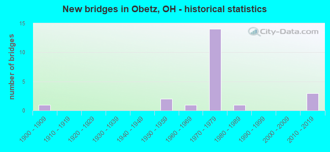
- New bridges - historical statistics
- 11900-1909
- 21950-1959
- 11960-1969
- 141970-1979
- 11980-1989
- 32010-2019

- Reconstructed bridges - Historical Statistics
- 11960-1969
- 01970-1979
- 01980-1989
- 61990-1999


- Bridge Condition - Deck
- 7.1%Very good
- 78.6%Good
- 7.1%Satisfactory
- 7.1%Poor

- Bridge Condition - Superstructure
- 28.6%Very good
- 57.1%Good
- 7.1%Satisfactory
- 7.1%Poor

- Bridge Condition - Substructure
- 21.4%Very good
- 64.3%Good
- 7.1%Satisfactory
- 7.1%Fair

- Bridge Condition - Channel
- 60.0%Very good
- 20.0%Satisfactory
- 20.0%Fair
Find on map >> Show street view
Structure Number: 2513595, Location: 4.77 MI S OF US33 (Lat: 39.872739, Lng: -82.969331), Route carried "on" structure: County highway C0013, Year Built: 1970, Status: Open, Structure Length: 8.60m (28.22ft), Average Daily Traffic: 7,771 (year 2015), Truck Traffic: 6%, Average Future Daily Traffic: 84,936 (year 2035), Design Load: H 20, Features Intersected: IR 270, Facility Carried by Structure: LOCKBOURNE RD
Minimum Vertical Clearance: 30+ m (98+ ft), Kilometerpoint: 0.000, Lanes on structure: 2, Lanes under structure: 6, Owner: State Highway Agency, Approaching Roadway Width: 13.4m (44.0ft), Material/Design: Steel continuous, Design/Construction: Stringer/Multi-beam, Number Of Spans In Main Unit: 4, Length of Maximum Span: 25.0m (82.0ft), Curb-To-Curb Width: 9.8m (32.2ft), Out-to-Out Width: 11.0m (36.1ft)
Condition: Deck: Good, Superstructure: Good, Substructure: Good, Operating Rating: 42.1 metric tons, Method Used To Determine Operating Rating: Load Factor (LF) rating reported by rating factor (RF) method using MS18 loading, Inventory Rating: 32.4 metric tons, Method Used To Determine Inventory Rating: Load Factor (LF) rating reported by rating factor (RF) method using MS18 loading, Structural Evaluation: Better than present minimum criteria, Deck Geometry: Meets minimum limits, Underclear: Somewhat better than minimum adequacy, Approach Roadway Alignment: Better than present minimum criteria, Designated Inspection Frequency: Every 24 months, Inspection Date: July 2021, Deck Structure Type: Concrete Cast-file-Place, Wearing Surface/Protective System: Wearing Surface: Latex Concrete, Deck Protection: Cathodic Protection
Find on map >> Show street view
Structure Number: 2513625, Location: 4.24 MI S OF US33 (Lat: 39.872411, Lng: -82.959631), Route carried "on" structure: Interstate 270, Year Built: 1970, Year Reconstructed: 2004, Status: Open, Structure Length: 4.91m (16.11ft), Average Daily Traffic: 30,597 (year 2015), Truck Traffic: 13%, Average Future Daily Traffic: 42,469 (year 2035), Design Load: HS 20+Mod, Features Intersected: OVER CSX RR
Minimum Vertical Clearance: 30+ m (98+ ft), Kilometerpoint: 81.063, Lanes on structure: 3, Base Highway Network: Yes, Owner: State Highway Agency, Approaching Roadway Width: 17.7m (58.1ft), Skew: 1 degrees, Material/Design: Steel continuous, Design/Construction: Stringer/Multi-beam, Number Of Spans In Main Unit: 3, Length of Maximum Span: 18.3m (60.0ft), Curb-To-Curb Width: 17.1m (56.1ft), Out-to-Out Width: 18.0m (59.1ft)
Condition: Deck: Good, Superstructure: Good, Substructure: Good, Operating Rating: 35.6 metric tons, Method Used To Determine Operating Rating: Allowable Stress (AS) rating reported by rating factor (RF) method using MS18 loading, Inventory Rating: 32.4 metric tons, Method Used To Determine Inventory Rating: Allowable Stress (AS) rating reported by rating factor (RF) method using MS18 loading, Structural Evaluation: Better than present minimum criteria, Deck Geometry: Equal to present minimum criteria, Underclear: Equal to present desirable criteria, Approach Roadway Alignment: Better than present minimum criteria, Designated Inspection Frequency: Every 24 months, Inspection Date: July 2021, Deck Structure Type: Concrete Cast-file-Place, Wearing Surface/Protective System: Wearing Surface: Monolithic Concrete, Deck Protection: Epoxy Coated Reinforcing
Find on map >> Show street view
Structure Number: 2513684, Location: 4.2J MI S OF US 33 (Lat: 39.872161, Lng: -82.959550), Route carried "on" structure: Interstate 270, Year Built: 1970, Year Reconstructed: 2004, Status: Open, Structure Length: 4.91m (16.11ft), Average Daily Traffic: 30,597 (year 2015), Truck Traffic: 13%, Average Future Daily Traffic: 42,469 (year 2035), Design Load: HS 20+Mod, Features Intersected: OVER CSX RR
Minimum Vertical Clearance: 30+ m (98+ ft), Kilometerpoint: 81.063, Lanes on structure: 3, Base Highway Network: Yes, Owner: State Highway Agency, Approaching Roadway Width: 17.7m (58.1ft), Skew: 1 degrees, Material/Design: Steel continuous, Design/Construction: Stringer/Multi-beam, Number Of Spans In Main Unit: 3, Length of Maximum Span: 18.3m (60.0ft), Curb-To-Curb Width: 17.1m (56.1ft), Out-to-Out Width: 18.0m (59.1ft)
Condition: Deck: Good, Superstructure: Good, Substructure: Good, Operating Rating: 35.6 metric tons, Method Used To Determine Operating Rating: Allowable Stress (AS) rating reported by rating factor (RF) method using MS18 loading, Inventory Rating: 32.4 metric tons, Method Used To Determine Inventory Rating: Allowable Stress (AS) rating reported by rating factor (RF) method using MS18 loading, Structural Evaluation: Better than present minimum criteria, Deck Geometry: Equal to present minimum criteria, Underclear: Superior to present desirable criteria, Approach Roadway Alignment: Better than present minimum criteria, Designated Inspection Frequency: Every 24 months, Inspection Date: July 2021, Deck Structure Type: Concrete Cast-file-Place, Wearing Surface/Protective System: Wearing Surface: Monolithic Concrete, Deck Protection: Epoxy Coated Reinforcing
Find on map >> Show street view
Structure Number: 2513714, Location: 3.76 MI S OF US 33 (Lat: 39.872011, Lng: -82.950800), Route carried "on" structure: Interstate 270, Year Built: 1970, Year Reconstructed: 2004, Status: Open, Structure Length: 6.16m (20.21ft), Average Daily Traffic: 30,597 (year 2015), Truck Traffic: 13%, Average Future Daily Traffic: 42,469 (year 2035), Design Load: HS 20+Mod, Features Intersected: OVER NS RR / OBETZ RD
Minimum Vertical Clearance: 30+ m (98+ ft), Kilometerpoint: 80.290, Lanes on structure: 3, Lanes under structure: 2, Base Highway Network: Yes, Owner: State Highway Agency, Approaching Roadway Width: 17.7m (58.1ft), Material/Design: Steel continuous, Design/Construction: Stringer/Multi-beam, Number Of Spans In Main Unit: 4, Length of Maximum Span: 16.8m (55.1ft), Curb-To-Curb Width: 17.1m (56.1ft), Out-to-Out Width: 18.0m (59.1ft)
Condition: Deck: Good, Superstructure: Good, Substructure: Good, Operating Rating: 35.6 metric tons, Method Used To Determine Operating Rating: Allowable Stress (AS) rating reported by rating factor (RF) method using MS18 loading, Inventory Rating: 32.4 metric tons, Method Used To Determine Inventory Rating: Allowable Stress (AS) rating reported by rating factor (RF) method using MS18 loading, Structural Evaluation: Better than present minimum criteria, Deck Geometry: Equal to present minimum criteria, Underclear: Superior to present desirable criteria, Approach Roadway Alignment: Better than present minimum criteria, Designated Inspection Frequency: Every 24 months, Inspection Date: July 2021, Deck Structure Type: Concrete Cast-file-Place, Wearing Surface/Protective System: Wearing Surface: Monolithic Concrete, Deck Protection: Epoxy Coated Reinforcing
Find on map >> Show street view
Structure Number: 2513749, Location: 3.76 MI S OF US33 (Lat: 39.871739, Lng: -82.950831), Route carried "on" structure: Interstate 270, Year Built: 1970, Year Reconstructed: 2004, Status: Open, Structure Length: 6.16m (20.21ft), Average Daily Traffic: 30,597 (year 2015), Truck Traffic: 13%, Average Future Daily Traffic: 42,469 (year 2035), Design Load: HS 20+Mod, Features Intersected: OVER NS RR / OBETZ RD
Minimum Vertical Clearance: 30+ m (98+ ft), Kilometerpoint: 80.290, Lanes on structure: 3, Lanes under structure: 2, Base Highway Network: Yes, Owner: State Highway Agency, Approaching Roadway Width: 17.7m (58.1ft), Material/Design: Steel continuous, Design/Construction: Stringer/Multi-beam, Number Of Spans In Main Unit: 4, Length of Maximum Span: 16.8m (55.1ft), Curb-To-Curb Width: 17.1m (56.1ft), Out-to-Out Width: 18.0m (59.1ft)
Condition: Deck: Good, Superstructure: Good, Substructure: Good, Operating Rating: 35.6 metric tons, Method Used To Determine Operating Rating: Allowable Stress (AS) rating reported by rating factor (RF) method using MS18 loading, Inventory Rating: 32.4 metric tons, Method Used To Determine Inventory Rating: Allowable Stress (AS) rating reported by rating factor (RF) method using MS18 loading, Structural Evaluation: Better than present minimum criteria, Deck Geometry: Equal to present minimum criteria, Underclear: Superior to present desirable criteria, Approach Roadway Alignment: Better than present minimum criteria, Designated Inspection Frequency: Every 24 months, Inspection Date: July 2021, Deck Structure Type: Concrete Cast-file-Place, Wearing Surface/Protective System: Wearing Surface: Monolithic Concrete, Deck Protection: Epoxy Coated Reinforcing
Find on map >> Show street view
Structure Number: 2513773, Location: 3.80 MI S OF US33 (Lat: 39.871461, Lng: -82.941589), Route carried "on" structure: City street M0007, Year Built: 1970, Status: Open, Structure Length: 11.47m (37.63ft), Average Daily Traffic: 6,400 (year 2015), Truck Traffic: 8%, Average Future Daily Traffic: 84,936 (year 2035), Design Load: H 20, Features Intersected: IR 270, Facility Carried by Structure: GROVEPORT RD
Minimum Vertical Clearance: 30+ m (98+ ft), Kilometerpoint: 0.000, Lanes on structure: 2, Lanes under structure: 6, Owner: State Highway Agency, Approaching Roadway Width: 13.4m (44.0ft), Skew: 4 degrees, Material/Design: Steel continuous, Design/Construction: Stringer/Multi-beam, Number Of Spans In Main Unit: 4, Length of Maximum Span: 34.1m (111.9ft), Curb-To-Curb Width: 9.8m (32.2ft), Out-to-Out Width: 11.0m (36.1ft)
Condition: Deck: Good, Superstructure: Good, Substructure: Good, Operating Rating: 45.4 metric tons, Method Used To Determine Operating Rating: Load Factor (LF) rating reported by rating factor (RF) method using MS18 loading, Inventory Rating: 25.9 metric tons, Method Used To Determine Inventory Rating: Load Factor (LF) rating reported by rating factor (RF) method using MS18 loading, Structural Evaluation: Equal to present minimum criteria, Deck Geometry: Meets minimum limits, Underclear: Somewhat better than minimum adequacy, Approach Roadway Alignment: Better than present minimum criteria, Designated Inspection Frequency: Every 24 months, Inspection Date: July 2021, Deck Structure Type: Concrete Cast-file-Place, Wearing Surface/Protective System: Wearing Surface: Integral Concrete
Find on map >> Show street view
Structure Number: 2513862, Location: 2.87 MI S OF US33 (Lat: 39.871500, Lng: -82.933750), Route carried "on" structure: County highway C0122, Year Built: 1970, Status: Open, Structure Length: 11.55m (37.89ft), Average Daily Traffic: 22,125 (year 2015), Truck Traffic: 7%, Average Future Daily Traffic: 84,936 (year 2035), Design Load: HS 20, Features Intersected: IR 270, Facility Carried by Structure: ALUM CREEK DR
Minimum Vertical Clearance: 30+ m (98+ ft), Kilometerpoint: 0.000, Lanes on structure: 2, Lanes under structure: 7, Base Highway Network: Yes, Owner: State Highway Agency, Approaching Roadway Width: 12.8m (42.0ft), Skew: 3 degrees, Material/Design: Steel continuous, Design/Construction: Stringer/Multi-beam, Number Of Spans In Main Unit: 4, Length of Maximum Span: 39.0m (128.0ft), Curb-To-Curb Width: 9.1m (29.9ft), Out-to-Out Width: 21.9m (71.9ft)
Condition: Deck: Good, Superstructure: Very good, Substructure: Good, Operating Rating: 42.1 metric tons, Method Used To Determine Operating Rating: Allowable Stress (AS) rating reported by rating factor (RF) method using MS18 loading, Inventory Rating: 32.4 metric tons, Method Used To Determine Inventory Rating: Allowable Stress (AS) rating reported by rating factor (RF) method using MS18 loading, Structural Evaluation: Better than present minimum criteria, Deck Geometry: Meets minimum limits, Underclear: Somewhat better than minimum adequacy, Approach Roadway Alignment: Equal to present desirable criteria, Designated Inspection Frequency: Every 24 months, Inspection Date: July 2021, Deck Structure Type: Concrete Cast-file-Place, Wearing Surface/Protective System: Wearing Surface: Integral Concrete
Find on map >> Show street view
Structure Number: 2513897, Location: 2.85 MI S OF US33 (Lat: 39.871519, Lng: -82.933539), Route carried "on" structure: County highway C0122, Year Built: 1970, Status: Open, Structure Length: 11.55m (37.89ft), Average Daily Traffic: 22,125 (year 2015), Truck Traffic: 7%, Average Future Daily Traffic: 84,936 (year 2035), Design Load: HS 20, Features Intersected: IR 270, Facility Carried by Structure: ALUM CREEK DR
Minimum Vertical Clearance: 30+ m (98+ ft), Kilometerpoint: 0.000, Lanes on structure: 2, Lanes under structure: 7, Base Highway Network: Yes, Owner: State Highway Agency, Approaching Roadway Width: 12.8m (42.0ft), Skew: 3 degrees, Material/Design: Steel continuous, Design/Construction: Stringer/Multi-beam, Number Of Spans In Main Unit: 4, Length of Maximum Span: 39.0m (128.0ft), Curb-To-Curb Width: 9.1m (29.9ft), Out-to-Out Width: 11.0m (36.1ft)
Condition: Deck: Good, Superstructure: Good, Substructure: Good, Operating Rating: 42.1 metric tons, Method Used To Determine Operating Rating: Allowable Stress (AS) rating reported by rating factor (RF) method using MS18 loading, Inventory Rating: 32.4 metric tons, Method Used To Determine Inventory Rating: Allowable Stress (AS) rating reported by rating factor (RF) method using MS18 loading, Structural Evaluation: Better than present minimum criteria, Deck Geometry: Meets minimum limits, Underclear: Somewhat better than minimum adequacy, Approach Roadway Alignment: Better than present minimum criteria, Designated Inspection Frequency: Every 24 months, Inspection Date: July 2021, Deck Structure Type: Concrete Cast-file-Place, Wearing Surface/Protective System: Wearing Surface: Integral Concrete
Find on map >> Show street view
Structure Number: 2530325, Location: AT BIXBY RD (Lat: 39.856200, Lng: -82.938331), Route carried "on" structure: County highway C0122, Year Built: 1959, Year Reconstructed: 2002, Status: Open, Structure Length: 8.90m (29.20ft), Average Daily Traffic: 8,164 (year 2015), Truck Traffic: 7%, Average Future Daily Traffic: 11,332 (year 2035), Design Load: H 20, Features Intersected: BIG WALNUT(ALUM CREEK DR, Facility Carried by Structure: ALUM CREEK DR
Minimum Vertical Clearance: 30+ m (98+ ft), Kilometerpoint: 3.009, Lanes on structure: 2, Base Highway Network: Yes, Owner: County Highway Agency, Approaching Roadway Width: 9.8m (32.2ft), Skew: 2 degrees, Material/Design: Steel continuous, Design/Construction: Stringer/Multi-beam, Number Of Spans In Main Unit: 4, Length of Maximum Span: 24.4m (80.1ft), Curb-To-Curb Width: 9.8m (32.2ft), Out-to-Out Width: 9.8m (32.2ft)
Condition: Deck: Satisfactory, Superstructure: Very good, Substructure: Very good, Channel: Very good, Operating Rating: 84.2 metric tons, Method Used To Determine Operating Rating: Load Factor (LF) rating reported by rating factor (RF) method using MS18 loading, Inventory Rating: 48.6 metric tons, Method Used To Determine Inventory Rating: Load Factor (LF) rating reported by rating factor (RF) method using MS18 loading, Structural Evaluation: Equal to present desirable criteria, Deck Geometry: Meets minimum limits, Waterway Adequacy: Equal to present minimum criteria, Approach Roadway Alignment: Better than present minimum criteria, Designated Inspection Frequency: Every 12 months, Inspection Date: October 2021, Deck Structure Type: Concrete Cast-file-Place, Wearing Surface/Protective System: Wearing Surface: Integral Concrete
Find on map >> Show street view
Structure Number: 2530333, Location: AT BIXBY RD (Lat: 39.856419, Lng: -82.938511), Route carried "on" structure: County highway C0122, Year Built: 1959, Year Reconstructed: 2002, Status: Open, Structure Length: 8.90m (29.20ft), Average Daily Traffic: 8,164 (year 2015), Truck Traffic: 7%, Average Future Daily Traffic: 11,332 (year 2035), Design Load: H 20, Features Intersected: BIG WALNUT(ALUM CREEK DR, Facility Carried by Structure: ALUM CREEK DR
Minimum Vertical Clearance: 30+ m (98+ ft), Kilometerpoint: 2.993, Lanes on structure: 2, Base Highway Network: Yes, Owner: County Highway Agency, Approaching Roadway Width: 14.9m (48.9ft), Skew: 2 degrees, Material/Design: Steel continuous, Design/Construction: Stringer/Multi-beam, Number Of Spans In Main Unit: 4, Length of Maximum Span: 24.4m (80.1ft), Curb-To-Curb Width: 9.8m (32.2ft), Out-to-Out Width: 9.8m (32.2ft)
Condition: Deck: Good, Superstructure: Very good, Substructure: Very good, Channel: Very good, Operating Rating: 84.2 metric tons, Method Used To Determine Operating Rating: Load Factor (LF) rating reported by rating factor (RF) method using MS18 loading, Inventory Rating: 48.6 metric tons, Method Used To Determine Inventory Rating: Load Factor (LF) rating reported by rating factor (RF) method using MS18 loading, Structural Evaluation: Equal to present desirable criteria, Deck Geometry: Meets minimum limits, Waterway Adequacy: Equal to present minimum criteria, Approach Roadway Alignment: Better than present minimum criteria, Designated Inspection Frequency: Every 24 months, Inspection Date: October 2021, Deck Structure Type: Concrete Cast-file-Place, Wearing Surface/Protective System: Wearing Surface: Integral Concrete
Find on map >> Show street view
Structure Number: 253074, Location: .15 MI EAST OF ALUM CR DR (Lat: 39.866919, Lng: -82.931700), Route carried "on" structure: County highway C0007, Year Built: 1964, Status: Open, Structure Length: 8.38m (27.49ft), Average Daily Traffic: 8,962 (year 2015), Truck Traffic: 7%, Average Future Daily Traffic: 12,439 (year 2035), Design Load: HS 20, Features Intersected: BIG WALNUT (GROVEPORT), Facility Carried by Structure: GROVEPORT RD
Minimum Vertical Clearance: 30+ m (98+ ft), Kilometerpoint: 7.725, Lanes on structure: 2, Owner: County Highway Agency, Approaching Roadway Width: 8.2m (26.9ft), Material/Design: Steel continuous, Design/Construction: Stringer/Multi-beam, Number Of Spans In Main Unit: 4, Length of Maximum Span: 22.9m (75.1ft), Curb-To-Curb Width: 9.9m (32.5ft), Out-to-Out Width: 9.9m (32.5ft)
Condition: Deck: Good, Superstructure: Satisfactory, Substructure: Satisfactory, Channel: Fair, Operating Rating: 58.3 metric tons, Method Used To Determine Operating Rating: Load Factor (LF) rating reported by rating factor (RF) method using MS18 loading, Inventory Rating: 35.6 metric tons, Method Used To Determine Inventory Rating: Load Factor (LF) rating reported by rating factor (RF) method using MS18 loading, Structural Evaluation: Equal to present minimum criteria, Deck Geometry: Meets minimum limits, Waterway Adequacy: Equal to present desirable criteria, Approach Roadway Alignment: Equal to present minimum criteria, Designated Inspection Frequency: Every 12 months, Inspection Date: October 2021, Deck Structure Type: Concrete Cast-file-Place, Wearing Surface/Protective System: Wearing Surface: Integral Concrete
Find on map >> Show street view
Structure Number: 2531933, Location: 0.23 MI SOUTH OF RATHMELL (Lat: 39.856689, Lng: -82.957100), Route carried "on" structure: County highway C0131, Year Built: 1909, Year Reconstructed: 1974, Status: Open, Structure Length: 6.80m (22.31ft), Average Daily Traffic: 1,397 (year 2015), Truck Traffic: 5%, Average Future Daily Traffic: 1,939 (year 2035), Design Load: HS 20, Features Intersected: BIG WALNUT CR(REESE RD), Facility Carried by Structure: REESE RD
Minimum Vertical Clearance: 30+ m (98+ ft), Kilometerpoint: 0.370, Lanes on structure: 2, Owner: County Highway Agency, Approaching Roadway Width: 11.6m (38.1ft), Material/Design: Prestressed concrete, Design/Construction: Box Beam or Girders - Multiple, Number Of Spans In Main Unit: 4, Length of Maximum Span: 24.7m (81.0ft), Curb-To-Curb Width: 11.1m (36.4ft), Out-to-Out Width: 11.1m (36.4ft)
Condition: Deck: Poor, Superstructure: Poor, Substructure: Fair, Channel: Satisfactory, Operating Rating: 42.1 metric tons, Method Used To Determine Operating Rating: Load Factor (LF) rating reported by rating factor (RF) method using MS18 loading, Inventory Rating: 32.4 metric tons, Method Used To Determine Inventory Rating: Load Factor (LF) rating reported by rating factor (RF) method using MS18 loading, Structural Evaluation: Meets minimum limits, Deck Geometry: Equal to present minimum criteria, Waterway Adequacy: Equal to present desirable criteria, Approach Roadway Alignment: Meets minimum limits, Designated Inspection Frequency: Every 12 months, Inspection Date: October 2021, Deck Structure Type: Concrete Cast-file-Place, Wearing Surface/Protective System: Wearing Surface: Bituminous
Find on map >> Show street view
Structure Number: 2532352, Location: SOUTH OF 270 (Lat: 39.867161, Lng: -82.935931), Route carried "on" structure: County highway C0007, Year Built: 2013, Status: Open, Structure Length: 6.55m (21.49ft), Average Daily Traffic: 8,108 (year 2015), Truck Traffic: 8%, Average Future Daily Traffic: 11,254 (year 2035), Design Load: HL 93, Features Intersected: ALUM CRK DR(GROVEPORT RD, Facility Carried by Structure: GROVEPORT RD
Minimum Vertical Clearance: 30+ m (98+ ft), Kilometerpoint: 7.483, Lanes on structure: 4, Lanes under structure: 9, Owner: County Highway Agency, Approaching Roadway Width: 12.2m (40.0ft), Material/Design: Steel continuous, Design/Construction: Stringer/Multi-beam, Number Of Spans In Main Unit: 2, Length of Maximum Span: 31.4m (103.0ft), Curb-To-Curb Width: 12.2m (40.0ft), Out-to-Out Width: 13.1m (43.0ft)
Condition: Deck: Very good, Superstructure: Very good, Substructure: Very good, Operating Rating: 45.4 metric tons, Method Used To Determine Operating Rating: Load and Resistance Factor Rating (LRFR) rating reported by rating factor(RF) method using HL-93 loadings, Inventory Rating: 35.6 metric tons, Method Used To Determine Inventory Rating: Load and Resistance Factor Rating (LRFR) rating reported by rating factor(RF) method using HL-93 loadings, Structural Evaluation: Equal to present desirable criteria, Deck Geometry: High priority of replacement, Underclear: High priority of corrective action, Approach Roadway Alignment: Equal to present desirable criteria, Designated Inspection Frequency: Every 24 months, Inspection Date: October 2021, Deck Structure Type: Concrete Cast-file-Place, Wearing Surface/Protective System: Wearing Surface: Monolithic Concrete, Deck Protection: Epoxy Coated Reinforcing
Find on map >> Show street view
Structure Number: 2535033, Location: 0.1 MI EAST OF BIXBY RD (Lat: 39.845711, Lng: -82.953219), Route carried "on" structure: County highway C0235, Year Built: 1988, Status: Open, Structure Length: 9.66m (31.69ft), Average Daily Traffic: 2,798 (year 2015), Truck Traffic: 9%, Average Future Daily Traffic: 3,884 (year 2035), Design Load: HS 20+Mod, Features Intersected: CSX & NS RR (ROHR), Facility Carried by Structure: ROHR RD
Minimum Vertical Clearance: 30+ m (98+ ft), Kilometerpoint: 1.545, Lanes on structure: 2, Owner: County Highway Agency, Approaching Roadway Width: 9.8m (32.2ft), Material/Design: Prestressed concrete, Design/Construction: Box Beam or Girders - Multiple, Number Of Spans In Main Unit: 6, Length of Maximum Span: 17.4m (57.1ft), Curb-To-Curb Width: 9.8m (32.2ft), Out-to-Out Width: 10.4m (34.1ft)
Condition: Deck: Good, Superstructure: Good, Substructure: Good, Operating Rating: 68.0 metric tons, Method Used To Determine Operating Rating: Load Factor (LF) rating reported by rating factor (RF) method using MS18 loading, Inventory Rating: 38.9 metric tons, Method Used To Determine Inventory Rating: Load Factor (LF) rating reported by rating factor (RF) method using MS18 loading, Structural Evaluation: Better than present minimum criteria, Deck Geometry: Meets minimum limits, Underclear: Equal to present desirable criteria, Approach Roadway Alignment: Equal to present desirable criteria, Designated Inspection Frequency: Every 24 months, Inspection Date: October 2021, Deck Structure Type: Concrete Cast-file-Place, Wearing Surface/Protective System: Wearing Surface: Monolithic Concrete, Deck Protection: Epoxy Coated Reinforcing
Find on map >> Show street view
Structure Number: 2536048, Location: E RAMP TO GROVEPORT BYPAS (Lat: 39.866811, Lng: -82.933661), Route carried "on" structure: County highway C0007, Year Built: 2013, Status: Open, Structure Length: 0.76m (2.49ft), Average Daily Traffic: 8,962 (year 2015), Truck Traffic: 7%, Average Future Daily Traffic: 12,439 (year 2035), Design Load: HL 93, Features Intersected: BOEHM DITCH(GROVEPORT RD, Facility Carried by Structure: GROVEPORT RD
Minimum Vertical Clearance: 30+ m (98+ ft), Kilometerpoint: 7.660, Lanes on structure: 3, Owner: County Highway Agency, Approaching Roadway Width: 12.2m (40.0ft), Skew: 23 degrees, Material/Design: Concrete, Design/Construction: Culvert, Number Of Spans In Main Unit: 1, Length of Maximum Span: 6.7m (22.0ft)
Condition: Channel: Very good, Culverts: Very good, Operating Rating: 97.2 metric tons, Method Used To Determine Operating Rating: Load Factor (LF) rating reported by rating factor (RF) method using MS18 loading, Inventory Rating: 68.0 metric tons, Method Used To Determine Inventory Rating: Load Factor (LF) rating reported by rating factor (RF) method using MS18 loading, Structural Evaluation: Equal to present desirable criteria, Waterway Adequacy: Superior to present desirable criteria, Approach Roadway Alignment: Equal to present desirable criteria, Designated Inspection Frequency: Every 24 months, Inspection Date: October 2021
Find on map >> Show street view
Structure Number: 2513595, Location: 4.77 MI S OF US33 (Lat: 39.872739, Lng: -82.969331), Route carried "under" structure: Interstate 270, Year Built: 1970, Structure Length: 0. m, Average Daily Traffic: 61,193 (year 2015), Truck Traffic: 13%, Features Intersected: UNDER LOCKBOURNE RD, Facility Carried by Structure: LOCKBOURNE RD
Minimum Vertical Clearance: 4.95m (16.24ft), Kilometerpoint: 81.916, Lanes on structure: 2, Lanes under structure: 6, Material/Design: Steel continuous, Design/Construction: Stringer/Multi-beam, Length of Maximum Span: 25.0m (82.0ft)
Find on map >> Show street view
Structure Number: 2513714, Location: 3.76 MI S OF US 33 (Lat: 39.872011, Lng: -82.950800), Route carried "under" structure: County highway 246, Year Built: 1970, Structure Length: 0. m, Average Daily Traffic: 1,886 (year 2015), Truck Traffic: 5%, Features Intersected: I-270 WB(OVER N&W OBETZ, Facility Carried by Structure: IR 270
Minimum Vertical Clearance: 6.83m (22.41ft), Kilometerpoint: 0.000, Lanes on structure: 3, Lanes under structure: 2, Material/Design: Steel continuous, Design/Construction: Stringer/Multi-beam, Length of Maximum Span: 16.8m (55.1ft)
Find on map >> Show street view
Structure Number: 2513749, Location: 3.76 MI S OF US33 (Lat: 39.871739, Lng: -82.950831), Route carried "under" structure: County highway 246, Year Built: 1970, Structure Length: 0. m, Average Daily Traffic: 1,886 (year 2015), Truck Traffic: 5%, Features Intersected: I-270 EB(OV N&W OBETZ RD, Facility Carried by Structure: IR 270
Minimum Vertical Clearance: 7.01m (23.00ft), Kilometerpoint: 0.000, Lanes on structure: 3, Lanes under structure: 2, Material/Design: Steel continuous, Design/Construction: Stringer/Multi-beam, Length of Maximum Span: 16.8m (55.1ft)
Find on map >> Show street view
Structure Number: 2513773, Location: 3.80 MI S OF US33 (Lat: 39.871461, Lng: -82.941589), Route carried "under" structure: Interstate 270, Year Built: 1970, Structure Length: 0. m, Average Daily Traffic: 61,193 (year 2015), Truck Traffic: 13%, Features Intersected: UNDER GROVEPORT RD, Facility Carried by Structure: GROVEPORT RD
Minimum Vertical Clearance: 4.95m (16.24ft), Kilometerpoint: 79.550, Lanes on structure: 2, Lanes under structure: 6, Material/Design: Steel continuous, Design/Construction: Stringer/Multi-beam, Length of Maximum Span: 34.1m (111.9ft)
Find on map >> Show street view
Structure Number: 2513862, Location: 2.87 MI S OF US33 (Lat: 39.871500, Lng: -82.933750), Route carried "under" structure: Interstate 270, Year Built: 1970, Structure Length: 0. m, Average Daily Traffic: 61,193 (year 2015), Truck Traffic: 13%, Features Intersected: UNDER ALUM CREEK DRIVE S, Facility Carried by Structure: ALUM CREEK DR
Minimum Vertical Clearance: 5.23m (17.16ft), Kilometerpoint: 78.858, Lanes on structure: 2, Lanes under structure: 7, Material/Design: Steel continuous, Design/Construction: Stringer/Multi-beam, Length of Maximum Span: 39.0m (128.0ft)
Find on map >> Show street view
Structure Number: 2513897, Location: 2.85 MI S OF US33 (Lat: 39.871519, Lng: -82.933539), Route carried "under" structure: Interstate 270, Year Built: 1970, Structure Length: 0. m, Average Daily Traffic: 61,193 (year 2015), Truck Traffic: 13%, Features Intersected: UNDER ALUM CREEK DRIVE N, Facility Carried by Structure: ALUM CREEK DR
Minimum Vertical Clearance: 5.18m (16.99ft), Kilometerpoint: 78.826, Lanes on structure: 2, Lanes under structure: 7, Material/Design: Steel continuous, Design/Construction: Stringer/Multi-beam, Length of Maximum Span: 39.0m (128.0ft)
Find on map >> Show street view
Structure Number: 2532352, Location: SOUTH OF 270 (Lat: 39.867161, Lng: -82.935931), Route carried "under" structure: County highway C0122, Year Built: 2013, Structure Length: 0. m, Average Daily Traffic: 16,327 (year 2015), Truck Traffic: 7%, Features Intersected: ALUM CRK DR(GROVEPORT RD, Facility Carried by Structure: GROVEPORT RD
Minimum Vertical Clearance: 5.26m (17.26ft), Kilometerpoint: 42.165, Lanes on structure: 4, Lanes under structure: 9, Material/Design: Steel continuous, Design/Construction: Stringer/Multi-beam, Length of Maximum Span: 31.4m (103.0ft)