Bridge Statistics for Oconto, Nebraska (NE)
Condition, Traffic, Stress, Structural Evaluation, Project Costs
- National Bridge Inventory (NBI) Statistics
- 11Number of bridges
- 56ft / 16.6mTotal length
- 5,290Total average daily traffic
- 1,024Total average daily truck traffic
- 7,140Total future (year 2033) average daily traffic
- National Bridge Inventory (NBI) Registered Bridges for Oconto
- No street view available for this location
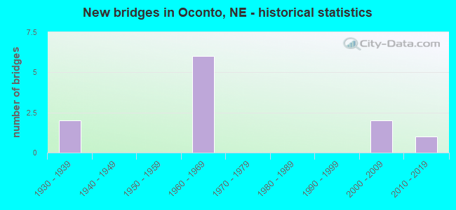
- New bridges - historical statistics
- 21930-1939
- 61960-1969
- 22000-2009
- 12010-2019


- Bridge Condition - Deck
- 50.0%Excellent
- 50.0%Fair

- Bridge Condition - Superstructure
- 50.0%Very good
- 50.0%Good

- Bridge Condition - Substructure
- 50.0%Good
- 25.0%Satisfactory
- 25.0%Fair

- Bridge Condition - Channel
- 9.1%Excellent
- 54.5%Very good
- 27.3%Good
- 9.1%Satisfactory

- Bridge Condition - Culverts
- 14.3%Excellent
- 71.4%Good
- 14.3%Satisfactory
Find on map >> Show street view
Structure Number: C002105503, Location: .5S 1E OF OCONTO NO. 509A (Lat: 41.135000, Lng: -99.740000), Route carried "on" structure: County highway 55, Year Built: 2014, Status: Open, Structure Length: 1.49m (4.89ft), Average Daily Traffic: 15 (year 2003), Average Future Daily Traffic: 25 (year 2033), Design Load: HL 93, Features Intersected: WOOD RIVER, Facility Carried by Structure: TOWNSHIP ROAD
Minimum Vertical Clearance: 30+ m (98+ ft), Kilometerpoint: 0.000, Lanes on structure: 2, Owner: County Highway Agency, Approaching Roadway Width: 6.7m (22.0ft), Material/Design: Steel, Design/Construction: Culvert, Number Of Spans In Main Unit: 4, Length of Maximum Span: 3.0m (9.8ft)
Condition: Channel: Very good, Culverts: Excellent, Operating Rating: 42.0 metric tons, Method Used To Determine Operating Rating: Field evaluation and documented engineering judgment, Inventory Rating: 33.0 metric tons, Method Used To Determine Inventory Rating: Field evaluation and documented engineering judgment, Structural Evaluation: Superior to present desirable criteria, Waterway Adequacy: Better than present minimum criteria, Approach Roadway Alignment: Equal to present desirable criteria, Length Of Structure Improvement: 0.98m (3.22ft), Designated Inspection Frequency: Every 24 months, Inspection Date: October 2020
Find on map >> Show street view
Structure Number: C002138605, Location: 1SE OF OCONTO (Lat: 41.132700, Lng: -99.745800), Route carried "on" structure: County highway 386, Year Built: 1930, Status: Posted for load, Structure Length: 1.01m (3.31ft), Average Daily Traffic: 15 (year 2003), Average Future Daily Traffic: 25 (year 2033), Features Intersected: STREAM, Facility Carried by Structure: TOWNSHIP ROAD
Minimum Vertical Clearance: 30+ m (98+ ft), Kilometerpoint: 0.000, Lanes on structure: 2, Owner: County Highway Agency, Approaching Roadway Width: 6.1m (20.0ft), Skew: 2 degrees, Material/Design: Wood or Timber, Design/Construction: Stringer/Multi-beam, Number Of Spans In Main Unit: 1, Length of Maximum Span: 9.4m (30.8ft), Curb-To-Curb Width: 5.5m (18.0ft), Out-to-Out Width: 5.7m (18.7ft)
Condition: Deck: Fair, Superstructure: Good, Substructure: Fair, Channel: Satisfactory, Operating Rating: 8.0 metric tons, Method Used To Determine Operating Rating: Allowable Stress (AS), Inventory Rating: 5.0 metric tons, Method Used To Determine Inventory Rating: Allowable Stress (AS), Structural Evaluation: High priority of replacement, Deck Geometry: Meets minimum limits, Waterway Adequacy: Somewhat better than minimum adequacy, Approach Roadway Alignment: Equal to present minimum criteria, Bridge Posting: Required (Relationship of Operating Rating to Maximum Legal Load: > 39.9% below), Length Of Structure Improvement: 1.01m (3.31ft), Designated Inspection Frequency: Every 24 months, Inspection Date: October 2020, Deck Structure Type: Wood or Timber, Wearing Surface/Protective System: Wearing Surface: Gravel
Find on map >> Show street view
Structure Number: C00214881, Location: 2SE OF OCONTO #567 (Lat: 41.118900, Lng: -99.727800), Route carried "on" structure: County highway 488, Year Built: 1935, Status: Posted for load, Structure Length: 1.31m (4.30ft), Average Daily Traffic: 5 (year 2003), Average Future Daily Traffic: 8 (year 2033), Features Intersected: WOOD RIVER, Facility Carried by Structure: RD 779
Minimum Vertical Clearance: 30+ m (98+ ft), Kilometerpoint: 0.000, Lanes on structure: 2, Owner: County Highway Agency, Approaching Roadway Width: 6.7m (22.0ft), Material/Design: Wood or Timber, Design/Construction: Stringer/Multi-beam, Number Of Spans In Main Unit: 2, Length of Maximum Span: 7.0m (23.0ft), Curb-To-Curb Width: 7.3m (24.0ft), Out-to-Out Width: 7.4m (24.3ft)
Condition: Deck: Fair, Superstructure: Good, Substructure: Satisfactory, Channel: Good, Operating Rating: 15.0 metric tons, Method Used To Determine Operating Rating: Allowable Stress (AS), Inventory Rating: 8.0 metric tons, Method Used To Determine Inventory Rating: Allowable Stress (AS), Structural Evaluation: High priority of replacement, Deck Geometry: Equal to present minimum criteria, Waterway Adequacy: Equal to present minimum criteria, Approach Roadway Alignment: Equal to present minimum criteria, Bridge Posting: Required (Relationship of Operating Rating to Maximum Legal Load: > 39.9% below), Length Of Structure Improvement: 1.31m (4.30ft), Designated Inspection Frequency: Every 24 months, Inspection Date: October 2020, Deck Structure Type: Wood or Timber, Wearing Surface/Protective System: Wearing Surface: Gravel
Find on map >> Show street view
Structure Number: S021 0516, Location: 1S OCONTO (Lat: 41.123400, Lng: -99.760247), Route carried "on" structure: State highway 21, Year Built: 1962, Year Reconstructed: 2021, Status: Open, Structure Length: 2.50m (8.20ft), Average Daily Traffic: 920 (year 2018), Truck Traffic: 26%, Average Future Daily Traffic: 1,196 (year 2038), Design Load: HL 93, Features Intersected: WOOD RIVER TRIB
Minimum Vertical Clearance: 30+ m (98+ ft), Kilometerpoint: 8.304, Lanes on structure: 2, Base Highway Network: Yes, Owner: State Highway Agency, Approaching Roadway Width: 11.0m (36.1ft), Material/Design: Prestressed concrete continuous, Design/Construction: Tee Beam, Number Of Spans In Main Unit: 3, Length of Maximum Span: 9.9m (32.5ft), Curb-To-Curb Width: 10.9m (35.8ft), Out-to-Out Width: 11.5m (37.7ft)
Condition: Deck: Excellent, Superstructure: Very good, Substructure: Good, Channel: Very good, Operating Rating: 78.0 metric tons, Method Used To Determine Operating Rating: Load and Resistance Factor (LRFR), Inventory Rating: 43.0 metric tons, Method Used To Determine Inventory Rating: Load and Resistance Factor (LRFR), Structural Evaluation: Better than present minimum criteria, Deck Geometry: Equal to present minimum criteria, Waterway Adequacy: Equal to present minimum criteria, Approach Roadway Alignment: Equal to present desirable criteria, Length Of Structure Improvement: 2.50m (8.20ft), Designated Inspection Frequency: Every 24 months, Inspection Date: November 2020, Deck Structure Type: Concrete Cast-file-Place, Wearing Surface/Protective System: Wearing Surface: Bituminous, Membrane: Preformed Fabric, Deck Protection: Epoxy Coated Reinforcing
Find on map >> Show street view
Structure Number: S021 05212, Location: 1S OCONTO (Lat: 41.130900, Lng: -99.759800), Route carried "on" structure: State highway 21, Year Built: 1962, Status: Open, Structure Length: 0.98m (3.22ft), Average Daily Traffic: 920 (year 2018), Truck Traffic: 26%, Average Future Daily Traffic: 1,196 (year 2038), Features Intersected: STREAM
Minimum Vertical Clearance: 30+ m (98+ ft), Kilometerpoint: 8.388, Lanes on structure: 2, Base Highway Network: Yes, Owner: State Highway Agency, Approaching Roadway Width: 7.9m (25.9ft), Skew: 1 degrees, Material/Design: Concrete, Design/Construction: Culvert, Number Of Spans In Main Unit: 3, Length of Maximum Span: 3.0m (9.8ft)
Condition: Channel: Good, Culverts: Satisfactory, Operating Rating: 33.0 metric tons, Method Used To Determine Operating Rating: Field evaluation and documented engineering judgment, Inventory Rating: 22.0 metric tons, Method Used To Determine Inventory Rating: Field evaluation and documented engineering judgment, Structural Evaluation: Somewhat better than minimum adequacy, Waterway Adequacy: Equal to present desirable criteria, Approach Roadway Alignment: Equal to present desirable criteria, Designated Inspection Frequency: Every 24 months, Inspection Date: November 2020
Find on map >> Show street view
Structure Number: S021 05305, Location: 1N OCONTO (Lat: 41.144400, Lng: -99.759300), Route carried "on" structure: State highway 21, Year Built: 2003, Status: Open, Structure Length: 1.28m (4.20ft), Average Daily Traffic: 830 (year 2018), Truck Traffic: 23%, Average Future Daily Traffic: 1,204 (year 2038), Design Load: HS 20, Features Intersected: SREAM
Minimum Vertical Clearance: 30+ m (98+ ft), Kilometerpoint: 8.538, Lanes on structure: 2, Base Highway Network: Yes, Owner: State Highway Agency, Approaching Roadway Width: 11.0m (36.1ft), Skew: 1 degrees, Material/Design: Concrete, Design/Construction: Culvert, Number Of Spans In Main Unit: 4, Length of Maximum Span: 12.2m (40.0ft)
Condition: Channel: Very good, Culverts: Good, Operating Rating: 43.0 metric tons, Method Used To Determine Operating Rating: Field evaluation and documented engineering judgment, Inventory Rating: 33.0 metric tons, Method Used To Determine Inventory Rating: Field evaluation and documented engineering judgment, Structural Evaluation: Better than present minimum criteria, Waterway Adequacy: Equal to present desirable criteria, Approach Roadway Alignment: Equal to present desirable criteria, Designated Inspection Frequency: Every 24 months, Inspection Date: November 2020
Find on map >> Show street view
Structure Number: S021 05328, Location: 1N OCONTO (Lat: 41.147300, Lng: -99.757200), Route carried "on" structure: State highway 21, Year Built: 2003, Status: Open, Structure Length: 2.82m (9.25ft), Average Daily Traffic: 830 (year 2018), Truck Traffic: 23%, Average Future Daily Traffic: 1,204 (year 2038), Design Load: HL 93, Features Intersected: WOOD RIVER
Minimum Vertical Clearance: 30+ m (98+ ft), Kilometerpoint: 8.575, Lanes on structure: 2, Base Highway Network: Yes, Owner: State Highway Agency, Approaching Roadway Width: 11.0m (36.1ft), Skew: 3 degrees, Material/Design: Steel, Design/Construction: Stringer/Multi-beam, Number Of Spans In Main Unit: 1, Length of Maximum Span: 27.7m (90.9ft), Curb-To-Curb Width: 10.9m (35.8ft), Out-to-Out Width: 11.5m (37.7ft)
Condition: Deck: Excellent, Superstructure: Very good, Substructure: Good, Channel: Excellent, Operating Rating: 47.0 metric tons, Method Used To Determine Operating Rating: Load and Resistance Factor (LRFR), Inventory Rating: 36.0 metric tons, Method Used To Determine Inventory Rating: Load and Resistance Factor (LRFR), Structural Evaluation: Better than present minimum criteria, Deck Geometry: Equal to present minimum criteria, Waterway Adequacy: Superior to present desirable criteria, Approach Roadway Alignment: Equal to present desirable criteria, Designated Inspection Frequency: Every 24 months, Inspection Date: November 2020, Deck Structure Type: Concrete Cast-file-Place, Wearing Surface/Protective System: Wearing Surface: Bituminous, Membrane: Preformed Fabric, Deck Protection: Epoxy Coated Reinforcing
Find on map >> Show street view
Structure Number: S040 0354, Location: 3NW OCONTO (Lat: 41.170800, Lng: -99.805200), Route carried "on" structure: State highway 40, Year Built: 1962, Year Reconstructed: 2004, Status: Open, Structure Length: 1.31m (4.30ft), Average Daily Traffic: 430 (year 2018), Truck Traffic: 10%, Average Future Daily Traffic: 559 (year 2038), Design Load: H 15, Features Intersected: WOOD RIVER
Minimum Vertical Clearance: 30+ m (98+ ft), Kilometerpoint: 5.697, Lanes on structure: 2, Base Highway Network: Yes, Owner: State Highway Agency, Approaching Roadway Width: 7.6m (24.9ft), Material/Design: Concrete, Design/Construction: Culvert, Number Of Spans In Main Unit: 4, Length of Maximum Span: 3.0m (9.8ft)
Condition: Channel: Very good, Culverts: Good, Operating Rating: 33.0 metric tons, Method Used To Determine Operating Rating: Field evaluation and documented engineering judgment, Inventory Rating: 22.0 metric tons, Method Used To Determine Inventory Rating: Field evaluation and documented engineering judgment, Structural Evaluation: Equal to present minimum criteria, Waterway Adequacy: Equal to present desirable criteria, Approach Roadway Alignment: Equal to present desirable criteria, Designated Inspection Frequency: Every 24 months, Inspection Date: November 2020
Find on map >> Show street view
Structure Number: S040 03619, Location: 2NW OCONTO (Lat: 41.162700, Lng: -99.794500), Route carried "on" structure: State highway 40, Year Built: 1962, Year Reconstructed: 2004, Status: Open, Structure Length: 1.55m (5.09ft), Average Daily Traffic: 430 (year 2018), Truck Traffic: 10%, Average Future Daily Traffic: 559 (year 2038), Design Load: H 15, Features Intersected: WOOD RIVER
Minimum Vertical Clearance: 30+ m (98+ ft), Kilometerpoint: 5.824, Lanes on structure: 2, Base Highway Network: Yes, Owner: State Highway Agency, Approaching Roadway Width: 7.6m (24.9ft), Material/Design: Concrete, Design/Construction: Culvert, Number Of Spans In Main Unit: 4, Length of Maximum Span: 3.7m (12.1ft)
Condition: Channel: Very good, Culverts: Good, Operating Rating: 33.0 metric tons, Method Used To Determine Operating Rating: Field evaluation and documented engineering judgment, Inventory Rating: 22.0 metric tons, Method Used To Determine Inventory Rating: Field evaluation and documented engineering judgment, Structural Evaluation: Equal to present minimum criteria, Waterway Adequacy: Equal to present desirable criteria, Approach Roadway Alignment: Equal to present desirable criteria, Designated Inspection Frequency: Every 24 months, Inspection Date: November 2020
Find on map >> Show street view
Structure Number: S040 03647, Location: 2NW OCONTO (Lat: 41.159900, Lng: -99.790700), Route carried "on" structure: State highway 40, Year Built: 1962, Year Reconstructed: 2004, Status: Open, Structure Length: 1.10m (3.61ft), Average Daily Traffic: 430 (year 2018), Truck Traffic: 10%, Average Future Daily Traffic: 559 (year 2038), Design Load: H 15, Features Intersected: STREAM
Minimum Vertical Clearance: 30+ m (98+ ft), Kilometerpoint: 5.869, Lanes on structure: 2, Base Highway Network: Yes, Owner: State Highway Agency, Approaching Roadway Width: 7.6m (24.9ft), Skew: 3 degrees, Material/Design: Concrete, Design/Construction: Culvert, Number Of Spans In Main Unit: 3, Length of Maximum Span: 3.0m (9.8ft)
Condition: Channel: Good, Culverts: Good, Operating Rating: 33.0 metric tons, Method Used To Determine Operating Rating: Field evaluation and documented engineering judgment, Inventory Rating: 22.0 metric tons, Method Used To Determine Inventory Rating: Field evaluation and documented engineering judgment, Structural Evaluation: Equal to present minimum criteria, Waterway Adequacy: Equal to present desirable criteria, Approach Roadway Alignment: Equal to present desirable criteria, Designated Inspection Frequency: Every 24 months, Inspection Date: November 2020
Find on map >> Show street view
Structure Number: S040 03926, Location: 1SE OCONTO (Lat: 41.130900, Lng: -99.752600), Route carried "on" structure: State highway 40, Year Built: 1968, Year Reconstructed: 1995, Status: Open, Structure Length: 1.28m (4.20ft), Average Daily Traffic: 465 (year 2018), Truck Traffic: 8%, Average Future Daily Traffic: 605 (year 2038), Design Load: HS 20, Features Intersected: STREAM
Minimum Vertical Clearance: 30+ m (98+ ft), Kilometerpoint: 6.318, Lanes on structure: 2, Base Highway Network: Yes, Owner: State Highway Agency, Approaching Roadway Width: 8.2m (26.9ft), Material/Design: Concrete, Design/Construction: Culvert, Number Of Spans In Main Unit: 4, Length of Maximum Span: 3.0m (9.8ft)
Condition: Channel: Very good, Culverts: Good, Operating Rating: 33.0 metric tons, Method Used To Determine Operating Rating: Field evaluation and documented engineering judgment, Inventory Rating: 22.0 metric tons, Method Used To Determine Inventory Rating: Field evaluation and documented engineering judgment, Structural Evaluation: Equal to present minimum criteria, Waterway Adequacy: Equal to present desirable criteria, Approach Roadway Alignment: Equal to present desirable criteria, Designated Inspection Frequency: Every 24 months, Inspection Date: November 2020