Bridge Statistics for Odenton, Maryland (MD)
Condition, Traffic, Stress, Structural Evaluation, Project Costs
- National Bridge Inventory (NBI) Statistics
- 15Number of bridges
- 131ft / 40.2mTotal length
- $866,000Total costs
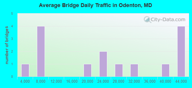
- 356,862Total average daily traffic
- 24,782Total average daily truck traffic
- National Bridge Inventory (NBI) Registered Bridges for Odenton
- No street view available for this location
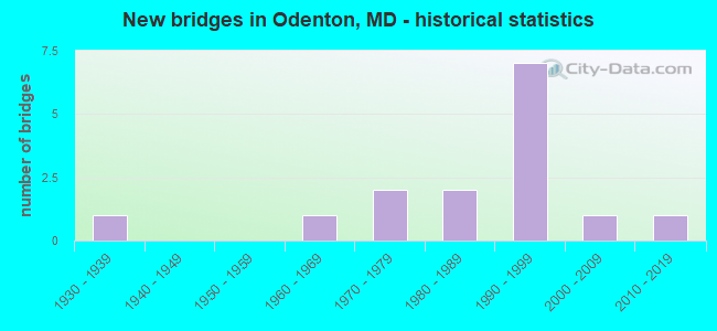
- New bridges - historical statistics
- 11930-1939
- 11960-1969
- 21970-1979
- 21980-1989
- 71990-1999
- 12000-2009
- 12010-2019
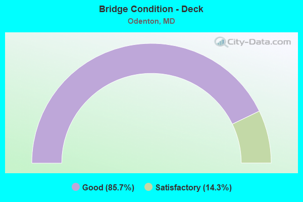
- Bridge Condition - Deck
- 85.7%Good
- 14.3%Satisfactory
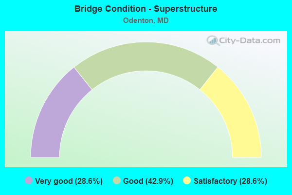
- Bridge Condition - Superstructure
- 28.6%Very good
- 42.9%Good
- 28.6%Satisfactory
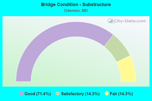
- Bridge Condition - Substructure
- 71.4%Good
- 14.3%Satisfactory
- 14.3%Fair
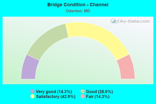
- Bridge Condition - Channel
- 14.3%Very good
- 28.6%Good
- 42.9%Satisfactory
- 14.3%Fair
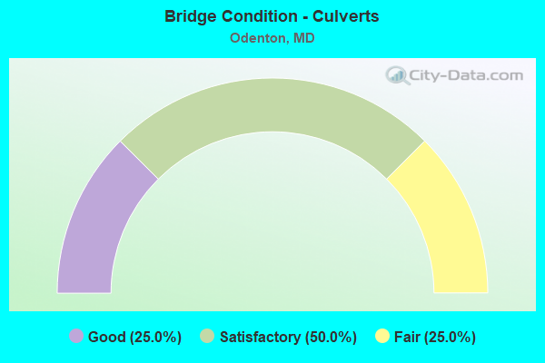
- Bridge Condition - Culverts
- 25.0%Good
- 50.0%Satisfactory
- 25.0%Fair
Find on map >> Show street view
Structure Number: 51640-00818, Location: BOUNDRY RD S OF GATE C (Lat: 39.060833, Lng: -76.737167), Route carried "on" structure: Federal lands road , Year Built: 2006, Status: Open, Structure Length: 3.17m (10.40ft), Average Daily Traffic: 50 (year 2021), Average Future Daily Traffic: 80 (year 2041), Features Intersected: LITTLE PATUXENT RIVER, Facility Carried by Structure: PATUXENT ROAD
Minimum Vertical Clearance: 30.48m (100.00ft), Kilometerpoint: 4.828, Lanes on structure: 2, Owner: Bureau of Fish and Wildlife, Approaching Roadway Width: 6.4m (21.0ft), Material/Design: Prestressed concrete, Design/Construction: Stringer/Multi-beam, Number Of Spans In Main Unit: 1, Length of Maximum Span: 30.5m (100.1ft), Curb or Sidewalk Widths: Left: 0.0m, Right: 2.0m (6.6ft), Curb-To-Curb Width: 7.4m (24.3ft), Out-to-Out Width: 10.5m (34.4ft)
Condition: Deck: Good, Superstructure: Very good, Substructure: Good, Channel: Good, Operating Rating: 56.2 metric tons, Method Used To Determine Operating Rating: Load Factor (LF), Inventory Rating: 32.7 metric tons, Method Used To Determine Inventory Rating: Load Factor (LF), Structural Evaluation: Better than present minimum criteria, Deck Geometry: Equal to present minimum criteria, Waterway Adequacy: Better than present minimum criteria, Approach Roadway Alignment: Somewhat better than minimum adequacy, Designated Inspection Frequency: Every 24 months, Inspection Date: August 2021, Deck Structure Type: Concrete Cast-file-Place, Wearing Surface/Protective System: Wearing Surface: Monolithic Concrete, Deck Protection: Epoxy Coated Reinforcing
Find on map >> Show street view
Structure Number: 10000002004801, Location: 0.37 MILE NORTH OF MD 170 (Lat: 39.089667, Lng: -76.705222), Route carried "on" structure: State highway 175, Year Built: 1938, Year Reconstructed: 1966, Status: Open, Structure Length: 5.97m (19.59ft), Average Daily Traffic: 28,180 (year 2018), Truck Traffic: 4%, Average Future Daily Traffic: 31,000 (year 2038), Design Load: HS 20, Features Intersected: AMTRAK
Minimum Vertical Clearance: 30+ m (98+ ft), Kilometerpoint: 5.834, Lanes on structure: 4, Owner: State Highway Agency, Approaching Roadway Width: 18.3m (60.0ft), Skew: 1 degrees, Material/Design: Steel, Design/Construction: Stringer/Multi-beam, Number Of Spans In Main Unit: 1, Number Of Approach Spans: 2, Length of Maximum Span: 25.6m (84.0ft), Curb or Sidewalk Widths: Left: 0.0m, Right: 1.9m (6.2ft), Curb-To-Curb Width: 18.3m (60.0ft), Out-to-Out Width: 20.7m (67.9ft)
Condition: Deck: Good, Superstructure: Satisfactory, Substructure: Fair, Operating Rating: 81.6 metric tons, Method Used To Determine Operating Rating: Load Factor (LF), Inventory Rating: 49.0 metric tons, Method Used To Determine Inventory Rating: Load Factor (LF), Structural Evaluation: Somewhat better than minimum adequacy, Deck Geometry: Somewhat better than minimum adequacy, Underclear: Better than present minimum criteria, Approach Roadway Alignment: Equal to present desirable criteria, Length Of Structure Improvement: 6.07m (19.91ft), Designated Inspection Frequency: Every 24 months, Inspection Date: June 2021, Bridge Improvement Cost: $726,000, Roadway Improvement Cost: $73,000, Total Project Cost: $799,000, Deck Structure Type: Concrete Cast-file-Place
Find on map >> Show street view
Structure Number: 10000002014501, Location: 0.35 MILE NORTH OF IS 97 (Lat: 39.064767, Lng: -76.644625), Route carried "on" structure: State highway 32, Year Built: 1989, Status: Open, Structure Length: 6.34m (20.80ft), Average Daily Traffic: 39,092 (year 2009), Truck Traffic: 8%, Average Future Daily Traffic: 58,638 (year 2029), Design Load: HS 20, Features Intersected: MD 3 NBR
Minimum Vertical Clearance: 30+ m (98+ ft), Kilometerpoint: 1.239, Lanes on structure: 3, Lanes under structure: 2, Base Highway Network: Yes, Owner: State Highway Agency, Approaching Roadway Width: 15.2m (49.9ft), Material/Design: Steel continuous, Design/Construction: Stringer/Multi-beam, Number Of Spans In Main Unit: 3, Length of Maximum Span: 24.4m (80.1ft), Curb-To-Curb Width: 15.2m (49.9ft), Out-to-Out Width: 16.5m (54.1ft)
Condition: Deck: Good, Superstructure: Satisfactory, Substructure: Good, Inventory Rating: 63.9 metric tons, Method Used To Determine Inventory Rating: Load Factor (LF), Structural Evaluation: Equal to present minimum criteria, Deck Geometry: Meets minimum limits, Underclear: Equal to present minimum criteria, Approach Roadway Alignment: Equal to present desirable criteria, Designated Inspection Frequency: Every 24 months, Inspection Date: April 2021, Deck Structure Type: Concrete Cast-file-Place, Wearing Surface/Protective System: Wearing Surface: Monolithic Concrete, Deck Protection: Epoxy Coated Reinforcing
Find on map >> Show street view
Structure Number: 10000002020403, Location: 0.37 MILE SOUTH OF MD 170 (Lat: 39.096525, Lng: -76.689372), Route carried "on" structure: State highway 32, Year Built: 1992, Status: Open, Structure Length: 2.30m (7.55ft), Average Daily Traffic: 42,672 (year 2009), Truck Traffic: 8%, Average Future Daily Traffic: 45,488 (year 2026), Design Load: HS 20, Features Intersected: PICTURE FRAME BRANCH
Minimum Vertical Clearance: 30+ m (98+ ft), Kilometerpoint: 6.710, Lanes on structure: 5, Base Highway Network: Yes, Owner: State Highway Agency, Approaching Roadway Width: 39.3m (128.9ft), Material/Design: Steel, Design/Construction: Culvert, Number Of Spans In Main Unit: 4, Length of Maximum Span: 5.2m (17.1ft)
Condition: Channel: Good, Culverts: Satisfactory, Structural Evaluation: Equal to present minimum criteria, Waterway Adequacy: Equal to present desirable criteria, Approach Roadway Alignment: Equal to present desirable criteria, Designated Inspection Frequency: Every 24 months, Inspection Date: April 2021
Find on map >> Show street view
Structure Number: 100000020205013, Location: 1.54 MI S OF MD 175 (Lat: 39.100444, Lng: -76.694308), Route carried "on" structure: State highway 32, Year Built: 1993, Status: Open, Structure Length: 4.91m (16.11ft), Average Daily Traffic: 43,672 (year 2009), Truck Traffic: 8%, Average Future Daily Traffic: 23,545 (year 2026), Design Load: HS 20, Features Intersected: MD 170
Minimum Vertical Clearance: 30+ m (98+ ft), Kilometerpoint: 7.284, Lanes on structure: 2, Lanes under structure: 6, Base Highway Network: Yes, Owner: State Highway Agency, Approaching Roadway Width: 11.6m (38.1ft), Skew: 2 degrees, Material/Design: Steel continuous, Design/Construction: Stringer/Multi-beam, Number Of Spans In Main Unit: 2, Length of Maximum Span: 26.2m (86.0ft), Curb-To-Curb Width: 11.6m (38.1ft), Out-to-Out Width: 13.0m (42.7ft)
Condition: Deck: Good, Superstructure: Good, Substructure: Good, Operating Rating: 78.5 metric tons, Method Used To Determine Operating Rating: Load Factor (LF), Inventory Rating: 47.2 metric tons, Method Used To Determine Inventory Rating: Load Factor (LF), Structural Evaluation: Better than present minimum criteria, Deck Geometry: Equal to present minimum criteria, Underclear: High priority of corrective action, Approach Roadway Alignment: Equal to present desirable criteria, Designated Inspection Frequency: Every 24 months, Inspection Date: Febuary 2022, Deck Structure Type: Concrete Cast-file-Place, Wearing Surface/Protective System: Wearing Surface: Monolithic Concrete, Deck Protection: Epoxy Coated Reinforcing
Find on map >> Show street view
Structure Number: 100000020205014, Location: 1.54 MI E OF MD 175 (Lat: 39.100461, Lng: -76.693811), Route carried "on" structure: State highway 32, Year Built: 1993, Status: Open, Structure Length: 4.91m (16.11ft), Average Daily Traffic: 43,672 (year 2009), Truck Traffic: 8%, Average Future Daily Traffic: 23,545 (year 2026), Design Load: HS 20, Features Intersected: MD 170
Minimum Vertical Clearance: 30+ m (98+ ft), Kilometerpoint: 7.284, Lanes on structure: 2, Lanes under structure: 6, Base Highway Network: Yes, Owner: State Highway Agency, Approaching Roadway Width: 12.5m (41.0ft), Skew: 2 degrees, Material/Design: Steel continuous, Design/Construction: Stringer/Multi-beam, Number Of Spans In Main Unit: 2, Length of Maximum Span: 26.2m (86.0ft), Curb-To-Curb Width: 12.5m (41.0ft), Out-to-Out Width: 14.0m (45.9ft)
Condition: Deck: Good, Superstructure: Good, Substructure: Good, Operating Rating: 81.2 metric tons, Method Used To Determine Operating Rating: Load Factor (LF), Inventory Rating: 48.5 metric tons, Method Used To Determine Inventory Rating: Load Factor (LF), Structural Evaluation: Better than present minimum criteria, Deck Geometry: Better than present minimum criteria, Underclear: High priority of corrective action, Approach Roadway Alignment: Equal to present desirable criteria, Designated Inspection Frequency: Every 24 months, Inspection Date: Febuary 2022, Deck Structure Type: Concrete Cast-file-Place, Wearing Surface/Protective System: Wearing Surface: Monolithic Concrete, Deck Protection: Epoxy Coated Reinforcing
Find on map >> Show street view
Structure Number: 200000AA400401, Location: 1.9 MI S OF WAUGH CH RD (Lat: 39.058919, Lng: -76.732067), Route carried "on" structure: County highway 1040, Year Built: 1966, Status: Open, Structure Length: 6.46m (21.19ft), Average Daily Traffic: 7,188 (year 2016), Truck Traffic: 5%, Average Future Daily Traffic: 8,684 (year 2035), Design Load: HS 20, Features Intersected: LITTLE PATUXENT RIVER, Facility Carried by Structure: PATUXENT ROAD
Minimum Vertical Clearance: 30+ m (98+ ft), Kilometerpoint: 4.553, Lanes on structure: 2, Owner: County Highway Agency, Approaching Roadway Width: 13.4m (44.0ft), Material/Design: Steel continuous, Design/Construction: Stringer/Multi-beam, Number Of Spans In Main Unit: 3, Length of Maximum Span: 24.4m (80.1ft), Curb or Sidewalk Widths: Left: 0.6m (2.0ft), Right: 0.6m (2.0ft), Curb-To-Curb Width: 9.1m (29.9ft), Out-to-Out Width: 11.0m (36.1ft)
Condition: Deck: Satisfactory, Superstructure: Good, Substructure: Satisfactory, Channel: Satisfactory, Operating Rating: 60.3 metric tons, Method Used To Determine Operating Rating: Allowable Stress (AS), Inventory Rating: 36.3 metric tons, Method Used To Determine Inventory Rating: Allowable Stress (AS), Structural Evaluation: Equal to present minimum criteria, Deck Geometry: Meets minimum limits, Waterway Adequacy: Better than present minimum criteria, Approach Roadway Alignment: Equal to present desirable criteria, Length Of Structure Improvement: 6.28m (20.60ft), Designated Inspection Frequency: Every 24 months, Inspection Date: June 2020, Bridge Improvement Cost: $67,000, Total Project Cost: $67,000, Deck Structure Type: Concrete Cast-file-Place, Wearing Surface/Protective System: Wearing Surface: Bituminous
Find on map >> Show street view
Structure Number: 200000AA401603, Location: 0.25 MI WEST OF MD 3 (Lat: 39.047114, Lng: -76.686775), Route carried "on" structure: County highway 1041, Year Built: 1972, Status: Open, Structure Length: 1.55m (5.09ft), Average Daily Traffic: 19,788 (year 2016), Truck Traffic: 2%, Average Future Daily Traffic: 24,658 (year 2038), Features Intersected: TOWSERS BRANCH, Facility Carried by Structure: WAUGH CHAPEL ROAD
Minimum Vertical Clearance: 30+ m (98+ ft), Kilometerpoint: 0.000, Lanes on structure: 2, Owner: County Highway Agency, Approaching Roadway Width: 13.4m (44.0ft), Material/Design: Steel, Design/Construction: Culvert, Number Of Spans In Main Unit: 3, Length of Maximum Span: 4.6m (15.1ft)
Condition: Channel: Fair, Culverts: Fair, Structural Evaluation: Somewhat better than minimum adequacy, Waterway Adequacy: Better than present minimum criteria, Approach Roadway Alignment: Equal to present desirable criteria, Designated Inspection Frequency: Every 24 months, Inspection Date: November 2021, Wearing Surface/Protective System: Wearing Surface: Bituminous
Find on map >> Show street view
Structure Number: 200000AA402903, Location: 0.65 MI E WAUGH CHAPEL RD (Lat: 39.062614, Lng: -76.688514), Route carried "on" structure: County highway , Year Built: 1974, Status: Open, Structure Length: 0.81m (2.66ft), Average Daily Traffic: 7,537 (year 2018), Truck Traffic: 3%, Average Future Daily Traffic: 10,200 (year 2040), Design Load: HS 20, Features Intersected: TOWSERS BRANCH, Facility Carried by Structure: DAIRY FARM ROAD
Minimum Vertical Clearance: 30+ m (98+ ft), Kilometerpoint: 1.823, Lanes on structure: 2, Owner: County Highway Agency, Approaching Roadway Width: 13.7m (44.9ft), Material/Design: Steel, Design/Construction: Culvert, Length of Maximum Span: 3.7m (12.1ft)
Condition: Channel: Satisfactory, Culverts: Satisfactory, Structural Evaluation: Equal to present minimum criteria, Waterway Adequacy: Better than present minimum criteria, Approach Roadway Alignment: Equal to present minimum criteria, Designated Inspection Frequency: Every 24 months, Inspection Date: August 2021
Find on map >> Show street view
Structure Number: 200000AA403301, Location: 0.3 MI SOUTH OF MD 32 (Lat: 39.096467, Lng: -76.706006), Route carried "on" structure: County highway , Year Built: 2018, Status: Open, Structure Length: 2.86m (9.38ft), Average Daily Traffic: 5,212 (year 2019), Truck Traffic: 2%, Average Future Daily Traffic: 8,400 (year 2039), Features Intersected: PICTURE SPRING BRANCH, Facility Carried by Structure: ODENTON TOWN CENTE
Minimum Vertical Clearance: 30+ m (98+ ft), Kilometerpoint: 0.000, Lanes on structure: 4, Owner: County Highway Agency, Approaching Roadway Width: 18.6m (61.0ft), Skew: 20 degrees, Material/Design: Steel, Design/Construction: Stringer/Multi-beam, Number Of Spans In Main Unit: 2, Length of Maximum Span: 15.9m (52.2ft), Curb or Sidewalk Widths: Left: 3.0m (9.8ft), Right: 1.4m (4.6ft), Curb-To-Curb Width: 17.8m (58.4ft), Out-to-Out Width: 31.7m (104.0ft)
Condition: Deck: Good, Superstructure: Very good, Substructure: Good, Channel: Very good, Operating Rating: 97.2 metric tons, Method Used To Determine Operating Rating: Load and Resistance Factor Rating (LRFR) rating reported by rating factor(RF) method using HL-93 loadings, Inventory Rating: 56.1 metric tons, Method Used To Determine Inventory Rating: Load and Resistance Factor Rating (LRFR) rating reported by rating factor(RF) method using HL-93 loadings, Structural Evaluation: Better than present minimum criteria, Deck Geometry: Somewhat better than minimum adequacy, Waterway Adequacy: Superior to present desirable criteria, Approach Roadway Alignment: Equal to present minimum criteria, Designated Inspection Frequency: Every 24 months, Inspection Date: July 2020, Deck Structure Type: Concrete Cast-file-Place
Find on map >> Show street view
Structure Number: 200000AA403403, Location: 0.6 MI S. of MD 170 (Lat: 39.052889, Lng: -76.713861), Route carried "on" structure: County highway , Year Built: 1999, Status: Open, Structure Length: 0.90m (2.95ft), Average Daily Traffic: 6,700 (year 2017), Average Future Daily Traffic: 8,174 (year 2037), Features Intersected: Tributary to Little Patu, Facility Carried by Structure: Strawberry Lake Wa
Minimum Vertical Clearance: 30+ m (98+ ft), Kilometerpoint: 1.931, Lanes on structure: 2, Owner: County Highway Agency, Approaching Roadway Width: 9.1m (29.9ft), Skew: 2 degrees, Material/Design: Steel, Design/Construction: Culvert, Length of Maximum Span: 8.8m (28.9ft), Curb or Sidewalk Widths: Left: 0.3m (1.0ft), Right: 0.1m (0.3ft)
Condition: Channel: Satisfactory, Culverts: Good, Structural Evaluation: Better than present minimum criteria, Waterway Adequacy: Equal to present desirable criteria, Approach Roadway Alignment: Equal to present desirable criteria, Designated Inspection Frequency: Every 24 months, Inspection Date: Febuary 2020, Wearing Surface/Protective System: Wearing Surface: Bituminous
Find on map >> Show street view
Structure Number: 10000002014501, Location: 0.76 MILE NORTH OF MD 175 (Lat: 39.064767, Lng: -76.644625), Route carried "under" structure: State highway 3, Year Built: 1989, Structure Length: 0. m, Average Daily Traffic: 27,185 (year 2006), Truck Traffic: 8%, Features Intersected: MD 3 NBR
Minimum Vertical Clearance: 8.53m (27.99ft), Kilometerpoint: 10.314, Lanes on structure: 2, Lanes under structure: 2, Material/Design: Steel continuous, Design/Construction: Stringer/Multi-beam, Length of Maximum Span: 24.4m (80.1ft)
Find on map >> Show street view
Structure Number: 10000002020301, Location: 1.71 MILE SOUTH OF MD 170 (Lat: 39.080272, Lng: -76.678269), Route carried "under" structure: State highway 32, Year Built: 1991, Structure Length: 0. m, Average Daily Traffic: 42,672 (year 2009), Truck Traffic: 8%, Features Intersected: MD 32
Minimum Vertical Clearance: 4.88m (16.01ft), Kilometerpoint: 4.553, Lanes on structure: 2, Lanes under structure: 4, Material/Design: Steel continuous, Design/Construction: Stringer/Multi-beam, Length of Maximum Span: 38.7m (127.0ft)
Find on map >> Show street view
Structure Number: 100000020205013, Location: 0.96 MILE NORTH OF MD 175 (Lat: 39.100444, Lng: -76.694308), Route carried "under" structure: State highway 170, Year Built: 1993, Structure Length: 0. m, Average Daily Traffic: 21,621 (year 2009), Truck Traffic: 8%, Features Intersected: MD 170, Facility Carried by Structure: MD 32 EBR
Minimum Vertical Clearance: 4.88m (16.01ft), Kilometerpoint: 1.545, Lanes on structure: 2, Lanes under structure: 5, Material/Design: Steel continuous, Design/Construction: Stringer/Multi-beam, Length of Maximum Span: 26.2m (86.0ft)
Find on map >> Show street view
Structure Number: 100000020205014, Location: 0.96 MILE NORTH OF MD 175 (Lat: 39.100461, Lng: -76.693811), Route carried "under" structure: State highway 170, Year Built: 1993, Structure Length: 0. m, Average Daily Traffic: 21,621 (year 2009), Truck Traffic: 8%, Features Intersected: MD 170, Facility Carried by Structure: MD 32 WBR
Minimum Vertical Clearance: 4.88m (16.01ft), Kilometerpoint: 1.545, Lanes on structure: 2, Lanes under structure: 5, Material/Design: Steel continuous, Design/Construction: Stringer/Multi-beam, Length of Maximum Span: 26.2m (86.0ft)