Bridge Statistics for Offutt AFB, Nebraska (NE)
Condition, Traffic, Stress, Structural Evaluation, Project Costs
- National Bridge Inventory (NBI) Statistics
- 11Number of bridges
- 223ft / 68.0mTotal length
- 94,086Total average daily traffic
- 2,813Total average daily truck traffic
- National Bridge Inventory (NBI) Registered Bridges for Offutt AFB
- No street view available for this location
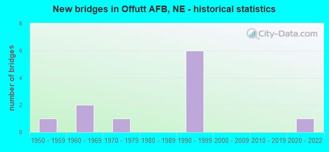
- New bridges - historical statistics
- 11950-1959
- 21960-1969
- 11970-1979
- 61990-1999
- 12020-2022


- Bridge Condition - Deck
- 50.0%Good
- 50.0%Fair

- Bridge Condition - Superstructure
- 50.0%Very good
- 25.0%Satisfactory
- 25.0%Poor

- Bridge Condition - Substructure
- 50.0%Good
- 50.0%Fair

- Bridge Condition - Channel
- 14.3%Excellent
- 28.6%Very good
- 57.1%Good

- Bridge Condition - Culverts
- 40.0%Very good
- 60.0%Good
Find on map >> Show street view
Structure Number: C007704324P, Location: .25S CAPEHART INTERCHG (Lat: 41.111900, Lng: -95.927800), Route carried "on" structure: County highway 5145, Year Built: 1975, Status: Open, Structure Length: 25.60m (83.99ft), Average Daily Traffic: 2,303 (year 2012), Average Future Daily Traffic: 2,303 (year 2033), Features Intersected: UP/BNSF/PAPIO, Facility Carried by Structure: S.B. FT CROOK RD
Minimum Vertical Clearance: 30+ m (98+ ft), Kilometerpoint: 16.105, Lanes on structure: 3, Base Highway Network: Yes, Owner: County Highway Agency, Approaching Roadway Width: 20.7m (67.9ft), Material/Design: Steel continuous, Design/Construction: Stringer/Multi-beam, Number Of Spans In Main Unit: 3, Number Of Approach Spans: 8, Length of Maximum Span: 41.1m (134.8ft), Curb or Sidewalk Widths: Left: 0.4m (1.3ft), Right: 0.7m (2.3ft), Curb-To-Curb Width: 12.2m (40.0ft), Out-to-Out Width: 18.7m (61.4ft)
Condition: Deck: Fair, Superstructure: Satisfactory, Substructure: Fair, Channel: Good, Operating Rating: 49.0 metric tons, Method Used To Determine Operating Rating: Load Factor (LF), Inventory Rating: 29.0 metric tons, Method Used To Determine Inventory Rating: Load Factor (LF), Structural Evaluation: Somewhat better than minimum adequacy, Deck Geometry: Meets minimum limits, Underclear: Meets minimum limits, Waterway Adequacy: Better than present minimum criteria, Approach Roadway Alignment: Equal to present desirable criteria, Length Of Structure Improvement: 25.60m (83.99ft), Designated Inspection Frequency: Every 24 months, Inspection Date: March 2020, Deck Structure Type: Concrete Cast-file-Place, Wearing Surface/Protective System: Wearing Surface: Bituminous, Membrane: Other
Find on map >> Show street view
Structure Number: C007704325P, Location: .25S CAPEHART INTERCHG (Lat: 41.112200, Lng: -95.927700), Route carried "on" structure: County highway 5145, Year Built: 1956, Year Reconstructed: 1975, Status: Open, Structure Length: 25.30m (83.01ft), Average Daily Traffic: 2,303 (year 2012), Average Future Daily Traffic: 2,303 (year 2033), Design Load: HS 20, Features Intersected: UP/BNSF/PAPIO 433-017-A, Facility Carried by Structure: N.B. FT CROOK RD
Minimum Vertical Clearance: 30+ m (98+ ft), Kilometerpoint: 16.105, Lanes on structure: 3, Base Highway Network: Yes, Owner: County Highway Agency, Approaching Roadway Width: 20.7m (67.9ft), Material/Design: Steel continuous, Design/Construction: Stringer/Multi-beam, Number Of Spans In Main Unit: 3, Number Of Approach Spans: 9, Length of Maximum Span: 39.6m (129.9ft), Curb or Sidewalk Widths: Left: 0.5m (1.6ft), Right: 0.4m (1.3ft), Curb-To-Curb Width: 12.2m (40.0ft), Out-to-Out Width: 13.1m (43.0ft)
Condition: Deck: Fair, Superstructure: Poor, Substructure: Fair, Channel: Good, Operating Rating: 35.0 metric tons, Method Used To Determine Operating Rating: Load Factor (LF), Inventory Rating: 22.0 metric tons, Method Used To Determine Inventory Rating: Load Factor (LF), Structural Evaluation: Meets minimum limits, Deck Geometry: Meets minimum limits, Underclear: Meets minimum limits, Waterway Adequacy: Better than present minimum criteria, Approach Roadway Alignment: Equal to present desirable criteria, Length Of Structure Improvement: 25.30m (83.01ft), Designated Inspection Frequency: Every 24 months, Inspection Date: December 2020, Deck Structure Type: Concrete Cast-file-Place, Wearing Surface/Protective System: Wearing Surface: Bituminous, Membrane: Other
Find on map >> Show street view
Structure Number: C007704330P, Location: CAPEHART RD INTRCHG (Lat: 41.114500, Lng: -95.926600), Route carried "on" structure: County highway 5000, Year Built: 1992, Status: Open, Structure Length: 4.21m (13.81ft), Average Daily Traffic: 24,680 (year 2012), Average Future Daily Traffic: 24,680 (year 2033), Design Load: HS 25 or greater, Features Intersected: FT CROOK RD/FAU 5145
Minimum Vertical Clearance: 30+ m (98+ ft), Kilometerpoint: 16.456, Lanes on structure: 4, Lanes under structure: 4, Base Highway Network: Yes, Owner: County Highway Agency, Approaching Roadway Width: 19.5m (64.0ft), Skew: 22 degrees, Material/Design: Steel continuous, Design/Construction: Stringer/Multi-beam, Number Of Spans In Main Unit: 2, Length of Maximum Span: 20.7m (67.9ft), Curb-To-Curb Width: 20.7m (67.9ft), Out-to-Out Width: 21.4m (70.2ft)
Condition: Deck: Good, Superstructure: Very good, Substructure: Good, Operating Rating: 80.0 metric tons, Method Used To Determine Operating Rating: Load Factor (LF), Inventory Rating: 47.0 metric tons, Method Used To Determine Inventory Rating: Load Factor (LF), Structural Evaluation: Better than present minimum criteria, Deck Geometry: Superior to present desirable criteria, Underclear: Equal to present minimum criteria, Approach Roadway Alignment: Equal to present desirable criteria, Designated Inspection Frequency: Every 24 months, Inspection Date: December 2020, Deck Structure Type: Concrete Cast-file-Place, Wearing Surface/Protective System: Wearing Surface: Monolithic Concrete, Deck Protection: Epoxy Coated Reinforcing
Find on map >> Show street view
Structure Number: C00770471, Location: E EDGE OF OFFUTT AFB (Lat: 41.111700, Lng: -95.890000), Route carried "on" structure: County highway 5109, Year Built: 1963, Status: Open, Structure Length: 1.71m (5.61ft), Average Daily Traffic: 1,185 (year 2010), Average Future Daily Traffic: 1,185 (year 2033), Features Intersected: STREAM, Facility Carried by Structure: HARLAN LEWIS RD
Minimum Vertical Clearance: 30+ m (98+ ft), Kilometerpoint: 16.143, Lanes on structure: 2, Owner: County Highway Agency, Approaching Roadway Width: 10.4m (34.1ft), Material/Design: Steel, Design/Construction: Culvert, Number Of Spans In Main Unit: 4, Length of Maximum Span: 3.0m (9.8ft)
Condition: Channel: Good, Culverts: Good, Operating Rating: 38.0 metric tons, Method Used To Determine Operating Rating: Field evaluation and documented engineering judgment, Inventory Rating: 33.0 metric tons, Method Used To Determine Inventory Rating: Field evaluation and documented engineering judgment, Structural Evaluation: Better than present minimum criteria, Waterway Adequacy: Equal to present desirable criteria, Approach Roadway Alignment: Equal to present desirable criteria, Designated Inspection Frequency: Every 24 months, Inspection Date: August 2020
Find on map >> Show street view
Structure Number: C007704715, Location: E EDGE OF OFFUTT AFB (Lat: 41.118600, Lng: -95.890000), Route carried "on" structure: County highway 5109, Year Built: 1963, Status: Open, Structure Length: 0.76m (2.49ft), Average Daily Traffic: 1,185 (year 2010), Average Future Daily Traffic: 1,235 (year 2033), Features Intersected: STREAM, Facility Carried by Structure: HARLAN LEWIS RD
Minimum Vertical Clearance: 30+ m (98+ ft), Kilometerpoint: 16.185, Lanes on structure: 2, Owner: County Highway Agency, Approaching Roadway Width: 10.4m (34.1ft), Material/Design: Steel, Design/Construction: Culvert, Number Of Spans In Main Unit: 2, Length of Maximum Span: 3.0m (9.8ft)
Condition: Channel: Good, Culverts: Good, Operating Rating: 38.0 metric tons, Method Used To Determine Operating Rating: Field evaluation and documented engineering judgment, Inventory Rating: 33.0 metric tons, Method Used To Determine Inventory Rating: Field evaluation and documented engineering judgment, Structural Evaluation: Better than present minimum criteria, Waterway Adequacy: Equal to present desirable criteria, Approach Roadway Alignment: Equal to present desirable criteria, Designated Inspection Frequency: Every 24 months, Inspection Date: November 2021
Find on map >> Show street view
Structure Number: S075 0792, Location: JCT US75/N370 1.8S .2W (Lat: 41.101500, Lng: -95.929600), Route carried "on" structure: US 75, Year Built: 1990, Status: Open, Structure Length: 1.04m (3.41ft), Average Daily Traffic: 13,250 (year 2018), Truck Traffic: 6%, Average Future Daily Traffic: 20,538 (year 2038), Design Load: HS 20+Mod, Features Intersected: STREAM
Minimum Vertical Clearance: 30+ m (98+ ft), Kilometerpoint: 12.746, Lanes on structure: 4, Base Highway Network: Yes, Owner: State Highway Agency, Approaching Roadway Width: 23.2m (76.1ft), Skew: 3 degrees, Material/Design: Concrete, Design/Construction: Culvert, Number Of Spans In Main Unit: 3, Length of Maximum Span: 2.7m (8.9ft)
Condition: Channel: Very good, Culverts: Good, Operating Rating: 43.0 metric tons, Method Used To Determine Operating Rating: Field evaluation and documented engineering judgment, Inventory Rating: 33.0 metric tons, Method Used To Determine Inventory Rating: Field evaluation and documented engineering judgment, Structural Evaluation: Better than present minimum criteria, Waterway Adequacy: Equal to present desirable criteria, Approach Roadway Alignment: Equal to present desirable criteria, Designated Inspection Frequency: Every 24 months, Inspection Date: January 2022
Find on map >> Show street view
Structure Number: S075 07926A, Location: JCT US75/N370 1.8S .2W (Lat: 41.103400, Lng: -95.928800), Route carried "on" structure: Ramp US 75, Year Built: 1990, Status: Open, Structure Length: 0.88m (2.89ft), Average Daily Traffic: 13,250 (year 2018), Truck Traffic: 6%, Average Future Daily Traffic: 20,538 (year 2038), Design Load: HS 20+Mod, Features Intersected: STREAM
Minimum Vertical Clearance: 30+ m (98+ ft), Kilometerpoint: 12.756, Lanes on structure: 1, Owner: State Highway Agency, Approaching Roadway Width: 8.2m (26.9ft), Skew: 1 degrees, Material/Design: Concrete, Design/Construction: Culvert, Number Of Spans In Main Unit: 3, Length of Maximum Span: 2.7m (8.9ft)
Condition: Channel: Very good, Culverts: Very good, Operating Rating: 43.0 metric tons, Method Used To Determine Operating Rating: Field evaluation and documented engineering judgment, Inventory Rating: 33.0 metric tons, Method Used To Determine Inventory Rating: Field evaluation and documented engineering judgment, Structural Evaluation: Equal to present desirable criteria, Waterway Adequacy: Equal to present desirable criteria, Approach Roadway Alignment: Equal to present desirable criteria, Designated Inspection Frequency: Every 24 months, Inspection Date: January 2022
Find on map >> Show street view
Structure Number: S075 07927A, Location: _ (Lat: 41.103700, Lng: -95.926400), Route carried "on" structure: City street 75, Year Built: 2020, Status: Open, Structure Length: 0.87m (2.85ft), Average Daily Traffic: 1,000 (year 2003), Truck Traffic: 10%, Average Future Daily Traffic: 1,550 (year 2033), Design Load: HL 93, Features Intersected: PAPILLION CR TRIB, Facility Carried by Structure: FAIRVIEW ROAD
Minimum Vertical Clearance: 30+ m (98+ ft), Kilometerpoint: 0.000, Lanes on structure: 2, Owner: State Highway Agency, Approaching Roadway Width: 9.1m (29.9ft), Material/Design: Concrete, Design/Construction: Culvert, Number Of Spans In Main Unit: 3, Length of Maximum Span: 2.7m (8.9ft), Curb-To-Curb Width: 9.1m (29.9ft), Out-to-Out Width: 9.1m (29.9ft)
Condition: Channel: Excellent, Culverts: Very good, Operating Rating: 66.0 metric tons, Method Used To Determine Operating Rating: Load and Resistance Factor (LRFR), Inventory Rating: 51.0 metric tons, Method Used To Determine Inventory Rating: Load and Resistance Factor (LRFR), Structural Evaluation: Equal to present desirable criteria, Deck Geometry: Equal to present minimum criteria, Waterway Adequacy: Meets minimum limits, Approach Roadway Alignment: Equal to present desirable criteria, Designated Inspection Frequency: Every 24 months, Inspection Date: January 2022
Find on map >> Show street view
Structure Number: S075 07939, Location: JCT US75/N370 2.5S .2W (Lat: 41.103900, Lng: -95.931100), Route carried "on" structure: County highway 414, Year Built: 1990, Status: Open, Structure Length: 7.62m (25.00ft), Average Daily Traffic: 1,000 (year 2003), Truck Traffic: 10%, Average Future Daily Traffic: 1,550 (year 2033), Features Intersected: US-75, Facility Carried by Structure: FAIRVIEW ROAD
Minimum Vertical Clearance: 30+ m (98+ ft), Kilometerpoint: 0.000, Lanes on structure: 2, Lanes under structure: 4, Owner: State Highway Agency, Approaching Roadway Width: 13.4m (44.0ft), Skew: 1 degrees, Material/Design: Prestressed concrete, Design/Construction: Stringer/Multi-beam, Number Of Spans In Main Unit: 2, Length of Maximum Span: 41.5m (136.2ft), Curb-To-Curb Width: 13.4m (44.0ft), Out-to-Out Width: 14.2m (46.6ft)
Condition: Deck: Good, Superstructure: Very good, Substructure: Good, Operating Rating: 66.0 metric tons, Method Used To Determine Operating Rating: Load Factor (LF), Inventory Rating: 40.0 metric tons, Method Used To Determine Inventory Rating: Load Factor (LF), Structural Evaluation: Better than present minimum criteria, Deck Geometry: Superior to present desirable criteria, Underclear: Equal to present desirable criteria, Approach Roadway Alignment: Equal to present desirable criteria, Designated Inspection Frequency: Every 24 months, Inspection Date: January 2022, Deck Structure Type: Concrete Cast-file-Place, Wearing Surface/Protective System: Wearing Surface: Monolithic Concrete, Deck Protection: Epoxy Coated Reinforcing
Find on map >> Show street view
Structure Number: C007704330P, Location: CAPEHART RD INTRCHG (Lat: 41.114500, Lng: -95.926600), Route carried "under" structure: County highway 5145, Year Built: 1992, Structure Length: 0. m, Average Daily Traffic: 13,470 (year 2012), Features Intersected: FT CROOK RD/FAU 5145, Facility Carried by Structure: CAPEHRT RD/FAU5000
Minimum Vertical Clearance: 4.62m (15.16ft), Kilometerpoint: 16.137, Lanes on structure: 4, Lanes under structure: 4, Material/Design: Steel continuous, Design/Construction: Stringer/Multi-beam, Length of Maximum Span: 20.7m (67.9ft)
Find on map >> Show street view
Structure Number: S075 07939, Location: JCT US75/N370 2.5S .2W (Lat: 41.103900, Lng: -95.931100), Route carried "under" structure: US 75, Year Built: 1990, Structure Length: 0. m, Average Daily Traffic: 20,460 (year 2012), Truck Traffic: 5%, Features Intersected: US-75, Facility Carried by Structure: FAIRVIEW ROAD
Minimum Vertical Clearance: 5.02m (16.47ft), Kilometerpoint: 12.777, Lanes on structure: 4, Lanes under structure: 4, Material/Design: Prestressed concrete, Design/Construction: Stringer/Multi-beam, Length of Maximum Span: 41.5m (136.2ft)