Bridge Statistics for Ogden, Kansas (KS)
Condition, Traffic, Stress, Structural Evaluation, Project Costs
- National Bridge Inventory (NBI) Statistics
- 35Number of bridges
- 925ft / 282mTotal length
- $380,000Total costs
- 197,025Total average daily traffic
- 20,990Total average daily truck traffic
- National Bridge Inventory (NBI) Registered Bridges for Ogden
- No street view available for this location
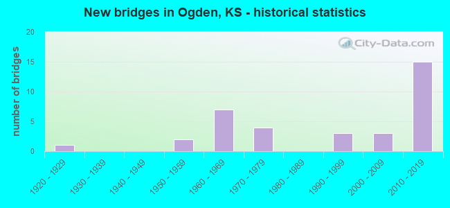
- New bridges - historical statistics
- 11920-1929
- 21950-1959
- 71960-1969
- 41970-1979
- 31990-1999
- 32000-2009
- 152010-2019

- Reconstructed bridges - Historical Statistics
- 11950-1959
- 01960-1969
- 01970-1979
- 11980-1989
- 41990-1999
- 02000-2009
- 12010-2019


- Bridge Condition - Deck
- 32.0%Very good
- 52.0%Good
- 12.0%Satisfactory
- 4.0%Poor

- Bridge Condition - Superstructure
- 60.0%Very good
- 28.0%Good
- 12.0%Satisfactory

- Bridge Condition - Substructure
- 48.0%Very good
- 40.0%Good
- 12.0%Satisfactory

- Bridge Condition - Channel
- 30.4%Very good
- 21.7%Good
- 34.8%Satisfactory
- 13.0%Fair

- Bridge Condition - Culverts
- 33.3%Very good
- 50.0%Good
- 16.7%Satisfactory
Find on map >> Show street view
Structure Number: 31001, Location: 1.8N 6.0E JUNCTION CITY (Lat: 39.055556, Lng: -96.720278), Route carried "on" structure: County highway 1089, Year Built: 1965, Status: Open, Structure Length: 1.10m (3.61ft), Average Daily Traffic: 196 (year 2004), Truck Traffic: 10%, Average Future Daily Traffic: 200 (year 2039), Design Load: HS 20, Features Intersected: TRIB. OF CLARKS CREEK, Facility Carried by Structure: HUMBOLDT CREEK RD.
Minimum Vertical Clearance: 30.47m (99.97ft), Kilometerpoint: 22.531, Lanes on structure: 2, Owner: County Highway Agency, Approaching Roadway Width: 7.3m (24.0ft), Skew: 4 degrees, Material/Design: Concrete, Design/Construction: Culvert, Number Of Spans In Main Unit: 2, Length of Maximum Span: 5.2m (17.1ft), Curb-To-Curb Width: 11.6m (38.1ft), Out-to-Out Width: 12.2m (40.0ft)
Condition: Channel: Satisfactory, Culverts: Good, Operating Rating: 32.4 metric tons, Method Used To Determine Operating Rating: Allowable Stress (AS), Inventory Rating: 24.3 metric tons, Method Used To Determine Inventory Rating: Allowable Stress (AS), Structural Evaluation: Equal to present minimum criteria, Deck Geometry: Superior to present desirable criteria, Waterway Adequacy: Equal to present minimum criteria, Approach Roadway Alignment: Equal to present desirable criteria, Length Of Structure Improvement: 12.19m (39.99ft), Designated Inspection Frequency: Every 24 months, Inspection Date: Febuary 2021, Bridge Improvement Cost: $200,000, Roadway Improvement Cost: $120,000, Total Project Cost: $380,000
Find on map >> Show street view
Structure Number: 310014, Location: 2.4N 9.5E JUNCTION CITY (Lat: 39.066111, Lng: -96.653056), Route carried "on" structure: County highway 1092, Year Built: 1964, Status: Posted for load, Structure Length: 3.11m (10.20ft), Average Daily Traffic: 220 (year 2004), Truck Traffic: 10%, Average Future Daily Traffic: 225 (year 2039), Features Intersected: MCDOWELL CR TRIB.
Minimum Vertical Clearance: 30.47m (99.97ft), Kilometerpoint: 19.232, Lanes on structure: 2, Owner: County Highway Agency, Approaching Roadway Width: 7.6m (24.9ft), Material/Design: Concrete continuous, Design/Construction: Slab, Number Of Spans In Main Unit: 3, Length of Maximum Span: 12.2m (40.0ft), Curb or Sidewalk Widths: Left: 0.8m (2.6ft), Right: 0.8m (2.6ft), Curb-To-Curb Width: 7.3m (24.0ft), Out-to-Out Width: 8.8m (28.9ft)
Condition: Deck: Satisfactory, Superstructure: Satisfactory, Substructure: Satisfactory, Channel: Fair, Operating Rating: 18.1 metric tons, Method Used To Determine Operating Rating: Field evaluation and documented engineering judgment, Inventory Rating: 18.1 metric tons, Method Used To Determine Inventory Rating: Field evaluation and documented engineering judgment, Structural Evaluation: Somewhat better than minimum adequacy, Deck Geometry: Somewhat better than minimum adequacy, Waterway Adequacy: Equal to present minimum criteria, Approach Roadway Alignment: Equal to present minimum criteria, Bridge Posting: Required (Relationship of Operating Rating to Maximum Legal Load: > 39.9% below), Designated Inspection Frequency: Every 24 months, Inspection Date: March 2021, Deck Structure Type: Concrete Cast-file-Place, Wearing Surface/Protective System: Wearing Surface: Bituminous
Find on map >> Show street view
Structure Number: 81026, Location: 2.8E 2.0S OF OGDEN (Lat: 39.080367, Lng: -96.655911), Route carried "on" structure: County highway 1092, Year Built: 2005, Status: Open, Structure Length: 2.83m (9.28ft), Average Daily Traffic: 400 (year 2004), Truck Traffic: 20%, Average Future Daily Traffic: 450 (year 2040), Design Load: HS 20, Features Intersected: MC DOWELL CREEK
Minimum Vertical Clearance: 30.47m (99.97ft), Kilometerpoint: 0.805, Lanes on structure: 2, Owner: County Highway Agency, Approaching Roadway Width: 6.7m (22.0ft), Skew: 2 degrees, Material/Design: Concrete continuous, Design/Construction: Slab, Number Of Spans In Main Unit: 3, Length of Maximum Span: 11.0m (36.1ft), Curb-To-Curb Width: 11.0m (36.1ft), Out-to-Out Width: 11.6m (38.1ft)
Condition: Deck: Good, Superstructure: Good, Substructure: Very good, Channel: Very good, Operating Rating: 68.4 metric tons, Method Used To Determine Operating Rating: Load Factor (LF), Inventory Rating: 41.0 metric tons, Method Used To Determine Inventory Rating: Load Factor (LF), Structural Evaluation: Better than present minimum criteria, Deck Geometry: Equal to present desirable criteria, Waterway Adequacy: Better than present minimum criteria, Approach Roadway Alignment: Somewhat better than minimum adequacy, Designated Inspection Frequency: Every 24 months, Inspection Date: December 2020, Deck Structure Type: Concrete Cast-file-Place, Wearing Surface/Protective System: Deck Protection: Epoxy Coated Reinforcing
Find on map >> Show street view
Structure Number: 310887404268, Location: 3.0N 6.0E JUNCTION CITY (Lat: 39.076667, Lng: -96.716111), Route carried "on" structure: County highway , Year Built: 2004, Status: Open, Structure Length: 4.59m (15.06ft), Average Daily Traffic: 10 (year 2015), Average Future Daily Traffic: 10 (year 2039), Design Load: HS 20, Features Intersected: CLARKS CREEK, Facility Carried by Structure: BOLLER RD 13.4-J8
Minimum Vertical Clearance: 30.47m (99.97ft), Kilometerpoint: 0.000, Lanes on structure: 2, Owner: County Highway Agency, Approaching Roadway Width: 8.5m (27.9ft), Skew: 1 degrees, Material/Design: Concrete continuous, Design/Construction: Slab, Number Of Spans In Main Unit: 3, Length of Maximum Span: 18.3m (60.0ft), Curb-To-Curb Width: 8.6m (28.2ft), Out-to-Out Width: 9.2m (30.2ft)
Condition: Deck: Good, Superstructure: Good, Substructure: Good, Channel: Good, Operating Rating: 54.4 metric tons, Method Used To Determine Operating Rating: Load Factor (LF), Inventory Rating: 32.7 metric tons, Method Used To Determine Inventory Rating: Load Factor (LF), Structural Evaluation: Better than present minimum criteria, Deck Geometry: Better than present minimum criteria, Waterway Adequacy: Equal to present desirable criteria, Approach Roadway Alignment: Better than present minimum criteria, Designated Inspection Frequency: Every 24 months, Inspection Date: Febuary 2021, Deck Structure Type: Concrete Cast-file-Place, Wearing Surface/Protective System: Wearing Surface: Monolithic Concrete
Find on map >> Show street view
Structure Number: 310895304282, Location: 2.0N 9.0E Junction City (Lat: 39.069944, Lng: -96.647861), Route carried "on" structure: Other road 935, Year Built: 2015, Status: Open, Structure Length: 1.40m (4.59ft), Average Daily Traffic: 2 (year 2015), Average Future Daily Traffic: 2 (year 2039), Design Load: HL 93, Features Intersected: McDOWELL CREEK, Facility Carried by Structure: PRESSEE RD
Minimum Vertical Clearance: 30.47m (99.97ft), Kilometerpoint: 0.000, Lanes on structure: 1, Owner: County Highway Agency, Approaching Roadway Width: 4.3m (14.1ft), Material/Design: Concrete, Design/Construction: Stringer/Multi-beam, Number Of Spans In Main Unit: 1, Length of Maximum Span: 13.7m (44.9ft), Curb-To-Curb Width: 4.3m (14.1ft), Out-to-Out Width: 4.3m (14.1ft)
Condition: Deck: Very good, Superstructure: Very good, Substructure: Very good, Channel: Satisfactory, Operating Rating: 44.6 metric tons, Method Used To Determine Operating Rating: Load and Resistance Factor (LRFR), Inventory Rating: 34.5 metric tons, Method Used To Determine Inventory Rating: Load and Resistance Factor (LRFR), Structural Evaluation: Equal to present desirable criteria, Deck Geometry: Equal to present minimum criteria, Waterway Adequacy: Equal to present minimum criteria, Approach Roadway Alignment: Meets minimum limits, Designated Inspection Frequency: Every 24 months, Inspection Date: March 2021, Deck Structure Type: Concrete Precast Panels, Wearing Surface/Protective System: Wearing Surface: Monolithic Concrete
Find on map >> Show street view
Structure Number: 8108879042, Location: 1.0N OF OGDEN (Lat: 39.131381, Lng: -96.707933), Route carried "on" structure: County highway , Year Built: 1950, Status: Open, Structure Length: 1.83m (6.00ft), Average Daily Traffic: 20 (year 2004), Average Future Daily Traffic: 25 (year 2040), Features Intersected: SEVEN MILE CREEK, Facility Carried by Structure: LOCAL N.9-30.0T
Minimum Vertical Clearance: 30.47m (99.97ft), Kilometerpoint: 0.000, Lanes on structure: 2, Owner: County Highway Agency, Approaching Roadway Width: 5.5m (18.0ft), Material/Design: Steel continuous, Design/Construction: Stringer/Multi-beam, Number Of Spans In Main Unit: 3, Length of Maximum Span: 6.7m (22.0ft), Curb or Sidewalk Widths: Left: 0.4m (1.3ft), Right: 0.4m (1.3ft), Curb-To-Curb Width: 5.5m (18.0ft), Out-to-Out Width: 6.3m (20.7ft)
Condition: Deck: Satisfactory, Superstructure: Satisfactory, Substructure: Satisfactory, Channel: Fair, Operating Rating: 40.5 metric tons, Method Used To Determine Operating Rating: Allowable Stress (AS), Inventory Rating: 27.0 metric tons, Method Used To Determine Inventory Rating: Allowable Stress (AS), Structural Evaluation: Equal to present minimum criteria, Deck Geometry: Meets minimum limits, Waterway Adequacy: Somewhat better than minimum adequacy, Approach Roadway Alignment: Equal to present desirable criteria, Designated Inspection Frequency: Every 24 months, Inspection Date: December 2020, Deck Structure Type: Concrete Cast-file-Place
Find on map >> Show street view
Structure Number: 81089170422, Location: 1.1E OF OGDEN (Lat: 39.116547, Lng: -96.680897), Route carried "on" structure: Other road , Year Built: 2015, Status: Open, Structure Length: 0.75m (2.46ft), Average Daily Traffic: 30 (year 2004), Truck Traffic: 2%, Average Future Daily Traffic: 35 (year 2040), Design Load: HL 93, Features Intersected: SEVEN MILE CREEK, Facility Carried by Structure: LOCAL P.6-31.0T
Minimum Vertical Clearance: 30.47m (99.97ft), Kilometerpoint: 0.000, Lanes on structure: 2, Owner: County Highway Agency, Approaching Roadway Width: 7.3m (24.0ft), Material/Design: Concrete, Design/Construction: Culvert, Number Of Spans In Main Unit: 2, Length of Maximum Span: 3.7m (12.1ft)
Condition: Channel: Very good, Culverts: Very good, Operating Rating: 62.1 metric tons, Method Used To Determine Operating Rating: Load and Resistance Factor (LRFR), Inventory Rating: 37.3 metric tons, Method Used To Determine Inventory Rating: Load and Resistance Factor (LRFR), Structural Evaluation: Equal to present desirable criteria, Waterway Adequacy: Equal to present desirable criteria, Approach Roadway Alignment: Equal to present desirable criteria, Designated Inspection Frequency: Every 24 months, Inspection Date: December 2020, Deck Structure Type: Concrete Cast-file-Place, Wearing Surface/Protective System: Wearing Surface: Gravel
Find on map >> Show street view
Structure Number: 521100810000001, Location: 8th and S Park (Lat: 39.109511, Lng: -96.707600), Route carried "on" structure: City street 63431, Year Built: 1973, Year Reconstructed: 1993, Status: Posted for load, Structure Length: 1.54m (5.05ft), Average Daily Traffic: 20 (year 2018), Average Future Daily Traffic: 20 (year 2040), Features Intersected: Dry Branch, Facility Carried by Structure: 8th St
Minimum Vertical Clearance: 30.47m (99.97ft), Kilometerpoint: 0.000, Lanes on structure: 2, Owner: City or Municipal Highway Agency, Approaching Roadway Width: 5.7m (18.7ft), Material/Design: Steel continuous, Design/Construction: Stringer/Multi-beam, Number Of Spans In Main Unit: 3, Length of Maximum Span: 6.9m (22.6ft), Curb-To-Curb Width: 6.2m (20.3ft), Out-to-Out Width: 6.2m (20.3ft)
Condition: Deck: Good, Superstructure: Satisfactory, Substructure: Satisfactory, Channel: Fair, Operating Rating: 13.6 metric tons, Method Used To Determine Operating Rating: Field evaluation and documented engineering judgment, Inventory Rating: 13.6 metric tons, Method Used To Determine Inventory Rating: Field evaluation and documented engineering judgment, Structural Evaluation: Meets minimum limits, Deck Geometry: Somewhat better than minimum adequacy, Waterway Adequacy: Equal to present minimum criteria, Approach Roadway Alignment: Meets minimum limits, Bridge Posting: Required (Relationship of Operating Rating to Maximum Legal Load: > 39.9% below), Designated Inspection Frequency: Every 24 months, Inspection Date: July 2020, Deck Structure Type: Concrete Cast-file-Place, Wearing Surface/Protective System: Wearing Surface: Bituminous
Find on map >> Show street view
Structure Number: 999901800310641, Location: 1.02 MI N I70 (Lat: 39.073056, Lng: -96.738056), Route carried "on" structure: State highway 18, Year Built: 1974, Status: Open, Structure Length: 4.78m (15.68ft), Average Daily Traffic: 7,385 (year 2020), Truck Traffic: 5%, Average Future Daily Traffic: 13,338 (year 2041), Design Load: HS 20, Features Intersected: Whiskey Lake Rd
Minimum Vertical Clearance: 30.47m (99.97ft), Kilometerpoint: 26.411, Lanes on structure: 2, Lanes under structure: 2, Base Highway Network: Yes, Owner: State Highway Agency, Approaching Roadway Width: 12.2m (40.0ft), Skew: 3 degrees, Material/Design: Concrete continuous, Design/Construction: Slab, Number Of Spans In Main Unit: 3, Length of Maximum Span: 18.9m (62.0ft), Curb-To-Curb Width: 13.4m (44.0ft), Out-to-Out Width: 14.1m (46.3ft)
Condition: Deck: Satisfactory, Superstructure: Good, Substructure: Good, Operating Rating: 68.0 metric tons, Method Used To Determine Operating Rating: Load Factor (LF), Inventory Rating: 40.8 metric tons, Method Used To Determine Inventory Rating: Load Factor (LF), Structural Evaluation: Better than present minimum criteria, Deck Geometry: Equal to present minimum criteria, Underclear: Equal to present minimum criteria, Approach Roadway Alignment: Equal to present desirable criteria, Length Of Structure Improvement: 15.69m (51.48ft), Designated Inspection Frequency: Every 24 months, Inspection Date: November 2021, Deck Structure Type: Concrete Cast-file-Place, Wearing Surface/Protective System: Wearing Surface: Low Slump Concrete
Find on map >> Show street view
Structure Number: 999901800310821, Location: 1.02 MI N I-70 (Lat: 39.073056, Lng: -96.738333), Route carried "on" structure: State highway 18, Year Built: 2006, Status: Open, Structure Length: 5.09m (16.70ft), Average Daily Traffic: 7,385 (year 2020), Truck Traffic: 5%, Average Future Daily Traffic: 13,338 (year 2041), Design Load: HS 25 or greater, Features Intersected: WHISKEY LAKE ROAD
Minimum Vertical Clearance: 30.47m (99.97ft), Kilometerpoint: 26.313, Lanes on structure: 2, Lanes under structure: 2, Base Highway Network: Yes, Owner: State Highway Agency, Approaching Roadway Width: 12.2m (40.0ft), Skew: 3 degrees, Material/Design: Concrete continuous, Design/Construction: Slab, Number Of Spans In Main Unit: 3, Length of Maximum Span: 20.0m (65.6ft), Curb-To-Curb Width: 12.2m (40.0ft), Out-to-Out Width: 12.8m (42.0ft)
Condition: Deck: Good, Superstructure: Very good, Substructure: Very good, Operating Rating: 75.3 metric tons, Method Used To Determine Operating Rating: Load Factor (LF), Inventory Rating: 45.4 metric tons, Method Used To Determine Inventory Rating: Load Factor (LF), Structural Evaluation: Equal to present desirable criteria, Deck Geometry: Better than present minimum criteria, Underclear: Superior to present desirable criteria, Approach Roadway Alignment: Equal to present desirable criteria, Length Of Structure Improvement: 16.70m (54.79ft), Designated Inspection Frequency: Every 24 months, Inspection Date: November 2021, Wearing Surface/Protective System: Wearing Surface: Monolithic Concrete, Deck Protection: Epoxy Coated Reinforcing
Find on map >> Show street view
Structure Number: 999901800810411, Location: 0.12 MI N GEARY CO LINE (Lat: 39.090278, Lng: -96.713333), Route carried "on" structure: State highway 18, Year Built: 1975, Status: Open, Structure Length: 36.71m (120.44ft), Average Daily Traffic: 7,385 (year 2020), Truck Traffic: 5%, Average Future Daily Traffic: 13,338 (year 2041), Design Load: HS 20, Features Intersected: KANSAS RIVER
Minimum Vertical Clearance: 30.47m (99.97ft), Kilometerpoint: 29.271, Lanes on structure: 2, Base Highway Network: Yes, Owner: State Highway Agency, Approaching Roadway Width: 13.4m (44.0ft), Skew: 2 degrees, Material/Design: Steel continuous, Design/Construction: Stringer/Multi-beam, Number Of Spans In Main Unit: 7, Length of Maximum Span: 56.4m (185.0ft), Curb-To-Curb Width: 13.4m (44.0ft), Out-to-Out Width: 13.8m (45.3ft)
Condition: Deck: Good, Superstructure: Very good, Substructure: Good, Channel: Satisfactory, Operating Rating: 78.0 metric tons, Method Used To Determine Operating Rating: Load Factor (LF), Inventory Rating: 47.2 metric tons, Method Used To Determine Inventory Rating: Load Factor (LF), Structural Evaluation: Better than present minimum criteria, Deck Geometry: Equal to present minimum criteria, Waterway Adequacy: Equal to present minimum criteria, Approach Roadway Alignment: Equal to present desirable criteria, Length Of Structure Improvement: 120.44m (395.14ft), Designated Inspection Frequency: Every 24 months, Inspection Date: November 2021, Deck Structure Type: Concrete Cast-file-Place, Wearing Surface/Protective System: Wearing Surface: Low Slump Concrete
Find on map >> Show street view
Structure Number: 999901800810421, Location: 1.12 N OF KANSAS RIVER (Lat: 39.104444, Lng: -96.702222), Route carried "on" structure: State highway 18, Year Built: 1976, Year Reconstructed: 2010, Status: Open, Structure Length: 0.97m (3.18ft), Average Daily Traffic: 6,667 (year 2020), Truck Traffic: 4%, Average Future Daily Traffic: 12,041 (year 2041), Design Load: H 20, Features Intersected: KANSAS RIVER DRAINAGE
Minimum Vertical Clearance: 30.47m (99.97ft), Kilometerpoint: 1.791, Lanes on structure: 4, Base Highway Network: Yes, Owner: State Highway Agency, Approaching Roadway Width: 13.4m (44.0ft), Skew: 20 degrees, Material/Design: Concrete, Design/Construction: Culvert, Number Of Spans In Main Unit: 3, Length of Maximum Span: 3.0m (9.8ft), Curb-To-Curb Width: 24.4m (80.1ft), Out-to-Out Width: 65.4m (214.6ft)
Condition: Channel: Good, Culverts: Good, Operating Rating: 51.7 metric tons, Method Used To Determine Operating Rating: Load Factor (LF), Inventory Rating: 30.8 metric tons, Method Used To Determine Inventory Rating: Load Factor (LF), Structural Evaluation: Better than present minimum criteria, Deck Geometry: Superior to present desirable criteria, Waterway Adequacy: Meets minimum limits, Approach Roadway Alignment: Equal to present desirable criteria, Length Of Structure Improvement: 3.17m (10.40ft), Designated Inspection Frequency: Every 24 months, Inspection Date: June 2021, Deck Structure Type: Concrete Cast-file-Place, Wearing Surface/Protective System: Wearing Surface: Monolithic Concrete
Find on map >> Show street view
Structure Number: 999901800810591, Location: 0.12 MI N GEARY CO LN (Lat: 39.090278, Lng: -96.713056), Route carried "on" structure: State highway 18, Year Built: 2011, Status: Open, Structure Length: 37.77m (123.92ft), Average Daily Traffic: 7,385 (year 2020), Truck Traffic: 5%, Average Future Daily Traffic: 13,338 (year 2041), Design Load: HL 93, Features Intersected: KANSAS RIVER
Minimum Vertical Clearance: 30.47m (99.97ft), Kilometerpoint: 0.003, Lanes on structure: 2, Base Highway Network: Yes, Owner: State Highway Agency, Approaching Roadway Width: 12.2m (40.0ft), Skew: 2 degrees, Material/Design: Steel continuous, Design/Construction: Stringer/Multi-beam, Number Of Spans In Main Unit: 7, Length of Maximum Span: 56.4m (185.0ft), Curb-To-Curb Width: 12.2m (40.0ft), Out-to-Out Width: 12.8m (42.0ft)
Condition: Deck: Good, Superstructure: Very good, Substructure: Very good, Channel: Good, Operating Rating: 60.6 metric tons, Method Used To Determine Operating Rating: Load and Resistance Factor Rating (LRFR) rating reported by rating factor(RF) method using HL-93 loadings, Inventory Rating: 46.7 metric tons, Method Used To Determine Inventory Rating: Load and Resistance Factor Rating (LRFR) rating reported by rating factor(RF) method using HL-93 loadings, Structural Evaluation: Equal to present desirable criteria, Deck Geometry: Better than present minimum criteria, Waterway Adequacy: Equal to present desirable criteria, Approach Roadway Alignment: Better than present minimum criteria, Length Of Structure Improvement: 123.91m (406.53ft), Designated Inspection Frequency: Every 24 months, Inspection Date: November 2021, Wearing Surface/Protective System: Wearing Surface: Low Slump Concrete, Deck Protection: Epoxy Coated Reinforcing
Find on map >> Show street view
Structure Number: 999901800810641, Location: 12TH STREET OVER K-18 (Lat: 39.096111, Lng: -96.708611), Route carried "on" structure: ServiceCounty highway 1536, Year Built: 2011, Status: Open, Structure Length: 8.93m (29.30ft), Average Daily Traffic: 41 (year 2020), Average Future Daily Traffic: 11,920 (year 2041), Design Load: HL 93, Features Intersected: K-18 WB/EB, Facility Carried by Structure: 12TH ST OVER K-18
Minimum Vertical Clearance: 30.47m (99.97ft), Kilometerpoint: 0.084, Lanes on structure: 2, Lanes under structure: 4, Owner: State Highway Agency, Approaching Roadway Width: 13.4m (44.0ft), Material/Design: Steel continuous, Design/Construction: Stringer/Multi-beam, Number Of Spans In Main Unit: 4, Length of Maximum Span: 28.0m (91.9ft), Curb-To-Curb Width: 13.4m (44.0ft), Out-to-Out Width: 14.1m (46.3ft)
Condition: Deck: Good, Superstructure: Very good, Substructure: Very good, Operating Rating: 52.2 metric tons, Method Used To Determine Operating Rating: Load and Resistance Factor Rating (LRFR) rating reported by rating factor(RF) method using HL-93 loadings, Inventory Rating: 40.5 metric tons, Method Used To Determine Inventory Rating: Load and Resistance Factor Rating (LRFR) rating reported by rating factor(RF) method using HL-93 loadings, Structural Evaluation: Equal to present desirable criteria, Deck Geometry: Superior to present desirable criteria, Underclear: Superior to present desirable criteria, Approach Roadway Alignment: Meets minimum limits, Length Of Structure Improvement: 29.31m (96.16ft), Designated Inspection Frequency: Every 24 months, Inspection Date: November 2021, Wearing Surface/Protective System: Wearing Surface: Monolithic Concrete, Deck Protection: Epoxy Coated Reinforcing
Find on map >> Show street view
Structure Number: 999901800810651, Location: 1.28 N OF KANSAS RIVER (Lat: 39.106111, Lng: -96.701111), Route carried "on" structure: City street 3899, Year Built: 2013, Status: Open, Structure Length: 9.46m (31.04ft), Average Daily Traffic: 522 (year 2020), Truck Traffic: 3%, Average Future Daily Traffic: 11,920 (year 2041), Design Load: HL 93, Features Intersected: K-18 HWY, Facility Carried by Structure: WALNUT STREET
Minimum Vertical Clearance: 30.47m (99.97ft), Kilometerpoint: 1.326, Lanes on structure: 2, Lanes under structure: 4, Owner: State Highway Agency, Approaching Roadway Width: 8.5m (27.9ft), Material/Design: Prestressed concrete continuous, Design/Construction: Stringer/Multi-beam, Number Of Spans In Main Unit: 4, Length of Maximum Span: 28.0m (91.9ft), Curb or Sidewalk Widths: Left: 0.0m, Right: 2.4m (7.9ft), Curb-To-Curb Width: 8.5m (27.9ft), Out-to-Out Width: 12.0m (39.4ft)
Condition: Deck: Very good, Superstructure: Very good, Substructure: Very good, Operating Rating: 58.6 metric tons, Method Used To Determine Operating Rating: Load and Resistance Factor Rating (LRFR) rating reported by rating factor(RF) method using HL-93 loadings, Inventory Rating: 32.1 metric tons, Method Used To Determine Inventory Rating: Load and Resistance Factor Rating (LRFR) rating reported by rating factor(RF) method using HL-93 loadings, Structural Evaluation: Better than present minimum criteria, Deck Geometry: Somewhat better than minimum adequacy, Underclear: Better than present minimum criteria, Approach Roadway Alignment: Somewhat better than minimum adequacy, Length Of Structure Improvement: 31.05m (101.87ft), Designated Inspection Frequency: Every 24 months, Inspection Date: June 2021, Wearing Surface/Protective System: Wearing Surface: Monolithic Concrete, Deck Protection: Epoxy Coated Reinforcing
Find on map >> Show street view
Structure Number: 999901800810701, Location: 0.27 MI NE JCT K114 & K18 (Lat: 39.118056, Lng: -96.691944), Route carried "on" structure: State highway 18, Year Built: 2011, Status: Open, Structure Length: 11.11m (36.45ft), Average Daily Traffic: 9,445 (year 2020), Truck Traffic: 3%, Average Future Daily Traffic: 15,477 (year 2041), Design Load: HL 93, Features Intersected: SEVEN MILE OVERFLOW CHNL
Minimum Vertical Clearance: 30.47m (99.97ft), Kilometerpoint: 3.594, Lanes on structure: 3, Base Highway Network: Yes, Owner: State Highway Agency, Approaching Roadway Width: 15.2m (49.9ft), Material/Design: Prestressed concrete continuous, Design/Construction: Stringer/Multi-beam, Number Of Spans In Main Unit: 4, Length of Maximum Span: 27.7m (90.9ft), Curb-To-Curb Width: 15.2m (49.9ft), Out-to-Out Width: 15.8m (51.8ft)
Condition: Deck: Very good, Superstructure: Very good, Substructure: Very good, Channel: Very good, Operating Rating: 60.9 metric tons, Method Used To Determine Operating Rating: Load and Resistance Factor Rating (LRFR) rating reported by rating factor(RF) method using HL-93 loadings, Inventory Rating: 37.9 metric tons, Method Used To Determine Inventory Rating: Load and Resistance Factor Rating (LRFR) rating reported by rating factor(RF) method using HL-93 loadings, Structural Evaluation: Equal to present desirable criteria, Deck Geometry: Meets minimum limits, Waterway Adequacy: Equal to present desirable criteria, Approach Roadway Alignment: Equal to present desirable criteria, Length Of Structure Improvement: 36.45m (119.59ft), Designated Inspection Frequency: Every 24 months, Inspection Date: June 2021, Wearing Surface/Protective System: Wearing Surface: Epoxy Overlay, Deck Protection: Epoxy Coated Reinforcing
Find on map >> Show street view
Structure Number: 999901800810711, Location: 0.27 MI NE JCT K114 & K18 (Lat: 39.118056, Lng: -96.692500), Route carried "on" structure: State highway 18, Year Built: 2011, Status: Open, Structure Length: 11.11m (36.45ft), Average Daily Traffic: 9,445 (year 2020), Truck Traffic: 3%, Average Future Daily Traffic: 15,477 (year 2041), Design Load: HL 93, Features Intersected: SEVEN MILE OVERFLOW CHNL
Minimum Vertical Clearance: 30.47m (99.97ft), Kilometerpoint: 3.607, Lanes on structure: 3, Base Highway Network: Yes, Owner: State Highway Agency, Approaching Roadway Width: 15.2m (49.9ft), Material/Design: Prestressed concrete continuous, Design/Construction: Stringer/Multi-beam, Number Of Spans In Main Unit: 4, Length of Maximum Span: 27.7m (90.9ft), Curb-To-Curb Width: 15.2m (49.9ft), Out-to-Out Width: 15.8m (51.8ft)
Condition: Deck: Very good, Superstructure: Very good, Substructure: Good, Channel: Very good, Operating Rating: 60.9 metric tons, Method Used To Determine Operating Rating: Load and Resistance Factor Rating (LRFR) rating reported by rating factor(RF) method using HL-93 loadings, Inventory Rating: 37.9 metric tons, Method Used To Determine Inventory Rating: Load and Resistance Factor Rating (LRFR) rating reported by rating factor(RF) method using HL-93 loadings, Structural Evaluation: Better than present minimum criteria, Deck Geometry: Meets minimum limits, Waterway Adequacy: Equal to present desirable criteria, Approach Roadway Alignment: Equal to present desirable criteria, Length Of Structure Improvement: 36.45m (119.59ft), Designated Inspection Frequency: Every 24 months, Inspection Date: June 2021, Wearing Surface/Protective System: Wearing Surface: Epoxy Overlay, Deck Protection: Epoxy Coated Reinforcing
Find on map >> Show street view
Structure Number: 999901800810721, Location: 2.61 MI NE GEARY COLN (Lat: 39.121667, Lng: -96.688611), Route carried "on" structure: State highway 18, Year Built: 2013, Status: Open, Structure Length: 33.91m (111.25ft), Average Daily Traffic: 9,445 (year 2020), Truck Traffic: 3%, Average Future Daily Traffic: 15,477 (year 2041), Design Load: HL 93, Features Intersected: UP RR & SEVEN MILE CREEK
Minimum Vertical Clearance: 30.47m (99.97ft), Kilometerpoint: 3.998, Lanes on structure: 2, Base Highway Network: Yes, Owner: State Highway Agency, Approaching Roadway Width: 12.2m (40.0ft), Skew: 4 degrees, Material/Design: Steel continuous, Design/Construction: Stringer/Multi-beam, Number Of Spans In Main Unit: 7, Length of Maximum Span: 61.6m (202.1ft), Curb-To-Curb Width: 12.2m (40.0ft), Out-to-Out Width: 13.0m (42.7ft)
Condition: Deck: Very good, Superstructure: Very good, Substructure: Very good, Channel: Good, Operating Rating: 46.3 metric tons, Method Used To Determine Operating Rating: Load and Resistance Factor Rating (LRFR) rating reported by rating factor(RF) method using HL-93 loadings, Inventory Rating: 36.0 metric tons, Method Used To Determine Inventory Rating: Load and Resistance Factor Rating (LRFR) rating reported by rating factor(RF) method using HL-93 loadings, Structural Evaluation: Equal to present desirable criteria, Deck Geometry: Better than present minimum criteria, Waterway Adequacy: Equal to present desirable criteria, Approach Roadway Alignment: Equal to present desirable criteria, Length Of Structure Improvement: 111.23m (364.93ft), Designated Inspection Frequency: Every 24 months, Inspection Date: June 2021, Deck Structure Type: Concrete Cast-file-Place, Wearing Surface/Protective System: Wearing Surface: Epoxy Overlay, Deck Protection: Epoxy Coated Reinforcing
Find on map >> Show street view
Structure Number: 999901800810731, Location: 2.59 MI NE GEARY COLN (Lat: 39.121667, Lng: -96.688889), Route carried "on" structure: State highway 18, Year Built: 2013, Status: Open, Structure Length: 38.78m (127.23ft), Average Daily Traffic: 9,445 (year 2020), Truck Traffic: 3%, Average Future Daily Traffic: 15,477 (year 2041), Design Load: HL 93, Features Intersected: UP RR & SEVEN MILE CREEK
Minimum Vertical Clearance: 30.47m (99.97ft), Kilometerpoint: 3.967, Lanes on structure: 2, Base Highway Network: Yes, Owner: State Highway Agency, Approaching Roadway Width: 12.2m (40.0ft), Skew: 4 degrees, Material/Design: Steel continuous, Design/Construction: Stringer/Multi-beam, Number Of Spans In Main Unit: 8, Length of Maximum Span: 61.6m (202.1ft), Curb-To-Curb Width: 12.2m (40.0ft), Out-to-Out Width: 13.0m (42.7ft)
Condition: Deck: Very good, Superstructure: Very good, Substructure: Very good, Channel: Very good, Operating Rating: 44.7 metric tons, Method Used To Determine Operating Rating: Load and Resistance Factor Rating (LRFR) rating reported by rating factor(RF) method using HL-93 loadings, Inventory Rating: 34.3 metric tons, Method Used To Determine Inventory Rating: Load and Resistance Factor Rating (LRFR) rating reported by rating factor(RF) method using HL-93 loadings, Structural Evaluation: Equal to present desirable criteria, Deck Geometry: Better than present minimum criteria, Waterway Adequacy: Equal to present desirable criteria, Approach Roadway Alignment: Equal to present desirable criteria, Length Of Structure Improvement: 127.23m (417.42ft), Designated Inspection Frequency: Every 24 months, Inspection Date: June 2021, Deck Structure Type: Concrete Cast-file-Place, Wearing Surface/Protective System: Wearing Surface: Epoxy Overlay, Deck Protection: Epoxy Coated Reinforcing
Find on map >> Show street view
Structure Number: 999907000310231, Location: 3.74 MI NE K57, WB (Lat: 39.061111, Lng: -96.730278), Route carried "on" structure: Interstate 70, Year Built: 1964, Year Reconstructed: 1997, Status: Open, Structure Length: 9.25m (30.35ft), Average Daily Traffic: 7,690 (year 2020), Truck Traffic: 27%, Average Future Daily Traffic: 11,427 (year 2041), Design Load: HS 20+Mod, Features Intersected: CLARKS CREEK
Minimum Vertical Clearance: 30.47m (99.97ft), Kilometerpoint: 22.724, Lanes on structure: 2, Base Highway Network: Yes, Owner: State Highway Agency, Approaching Roadway Width: 12.2m (40.0ft), Material/Design: Steel continuous, Design/Construction: Stringer/Multi-beam, Number Of Spans In Main Unit: 4, Length of Maximum Span: 25.9m (85.0ft), Curb-To-Curb Width: 12.2m (40.0ft), Out-to-Out Width: 12.8m (42.0ft)
Condition: Deck: Good, Superstructure: Very good, Substructure: Good, Channel: Good, Operating Rating: 58.6 metric tons, Method Used To Determine Operating Rating: Load Factor (LF), Inventory Rating: 35.1 metric tons, Method Used To Determine Inventory Rating: Load Factor (LF), Structural Evaluation: Better than present minimum criteria, Deck Geometry: Better than present minimum criteria, Waterway Adequacy: Equal to present minimum criteria, Approach Roadway Alignment: Equal to present desirable criteria, Length Of Structure Improvement: 30.35m (99.57ft), Designated Inspection Frequency: Every 24 months, Inspection Date: November 2021, Deck Structure Type: Concrete Cast-file-Place, Wearing Surface/Protective System: Wearing Surface: Low Slump Concrete
Find on map >> Show street view
Structure Number: 999907000310241, Location: 3.73 MI NE K57, EB (Lat: 39.060833, Lng: -96.730278), Route carried "on" structure: Interstate 70, Year Built: 1952, Year Reconstructed: 1997, Status: Open, Structure Length: 9.22m (30.25ft), Average Daily Traffic: 7,690 (year 2020), Truck Traffic: 27%, Average Future Daily Traffic: 11,427 (year 2041), Design Load: HS 25 or greater, Features Intersected: CLARKS CREEK
Minimum Vertical Clearance: 30.47m (99.97ft), Kilometerpoint: 22.729, Lanes on structure: 2, Base Highway Network: Yes, Owner: State Highway Agency, Approaching Roadway Width: 12.2m (40.0ft), Material/Design: Steel continuous, Design/Construction: Stringer/Multi-beam, Number Of Spans In Main Unit: 4, Length of Maximum Span: 25.9m (85.0ft), Curb-To-Curb Width: 12.2m (40.0ft), Out-to-Out Width: 12.8m (42.0ft)
Condition: Deck: Good, Superstructure: Good, Substructure: Good, Channel: Satisfactory, Operating Rating: 58.6 metric tons, Method Used To Determine Operating Rating: Load Factor (LF), Inventory Rating: 35.1 metric tons, Method Used To Determine Inventory Rating: Load Factor (LF), Structural Evaluation: Better than present minimum criteria, Deck Geometry: Better than present minimum criteria, Waterway Adequacy: Better than present minimum criteria, Approach Roadway Alignment: Equal to present desirable criteria, Length Of Structure Improvement: 30.25m (99.25ft), Designated Inspection Frequency: Every 24 months, Inspection Date: November 2021, Wearing Surface/Protective System: Wearing Surface: Monolithic Concrete, Deck Protection: Epoxy Coated Reinforcing
Find on map >> Show street view
Structure Number: 999907000310251, Location: 4.24 MI NE K57 (Lat: 39.061944, Lng: -96.720833), Route carried "on" structure: Interstate 70, Year Built: 1964, Year Reconstructed: 1997, Status: Open, Structure Length: 0.85m (2.79ft), Average Daily Traffic: 7,538 (year 2020), Truck Traffic: 27%, Average Future Daily Traffic: 11,201 (year 2041), Design Load: HS 20+Mod, Features Intersected: HUMBOLDT CREEK RD
Minimum Vertical Clearance: 30.47m (99.97ft), Kilometerpoint: 23.540, Lanes on structure: 6, Lanes under structure: 2, Base Highway Network: Yes, Owner: State Highway Agency, Approaching Roadway Width: 24.4m (80.1ft), Skew: 20 degrees, Material/Design: Concrete, Design/Construction: Culvert, Number Of Spans In Main Unit: 1, Length of Maximum Span: 8.5m (27.9ft), Curb-To-Curb Width: 31.7m (104.0ft), Out-to-Out Width: 45.1m (148.0ft)
Condition: Culverts: Satisfactory, Operating Rating: 60.1 metric tons, Method Used To Determine Operating Rating: Load Factor (LF), Inventory Rating: 36.0 metric tons, Method Used To Determine Inventory Rating: Load Factor (LF), Structural Evaluation: Equal to present minimum criteria, Deck Geometry: Superior to present desirable criteria, Underclear: High priority of corrective action, Approach Roadway Alignment: Equal to present desirable criteria, Length Of Structure Improvement: 2.80m (9.19ft), Designated Inspection Frequency: Every 24 months, Inspection Date: November 2021, Deck Structure Type: Concrete Cast-file-Place, Wearing Surface/Protective System: Wearing Surface: Monolithic Concrete
Find on map >> Show street view
Structure Number: 999907000310261, Location: 7.69 MI NE K57 (Lat: 39.066389, Lng: -96.656944), Route carried "on" structure: County highway 1092, Year Built: 1964, Status: Open, Structure Length: 7.04m (23.10ft), Average Daily Traffic: 510 (year 2020), Average Future Daily Traffic: 11,070 (year 2041), Design Load: H 20, Features Intersected: I70 HWY, EB/WB, Facility Carried by Structure: MCDOWELL RD
Minimum Vertical Clearance: 30.47m (99.97ft), Kilometerpoint: 19.105, Lanes on structure: 2, Lanes under structure: 4, Owner: State Highway Agency, Approaching Roadway Width: 8.5m (27.9ft), Material/Design: Steel continuous, Design/Construction: Stringer/Multi-beam, Number Of Spans In Main Unit: 4, Length of Maximum Span: 20.7m (67.9ft), Curb-To-Curb Width: 8.5m (27.9ft), Out-to-Out Width: 9.1m (29.9ft)
Condition: Deck: Poor, Superstructure: Good, Substructure: Good, Operating Rating: 40.0 metric tons, Method Used To Determine Operating Rating: Load Factor (LF), Inventory Rating: 23.9 metric tons, Method Used To Determine Inventory Rating: Load Factor (LF), Structural Evaluation: Equal to present minimum criteria, Deck Geometry: Somewhat better than minimum adequacy, Underclear: Equal to present minimum criteria, Approach Roadway Alignment: Meets minimum limits, Length Of Structure Improvement: 23.10m (75.79ft), Designated Inspection Frequency: Every 24 months, Inspection Date: November 2021, Deck Structure Type: Concrete Cast-file-Place, Wearing Surface/Protective System: Wearing Surface: Low Slump Concrete
Find on map >> Show street view
Structure Number: 999907000310281, Location: 7.94 MI NE K57, WB (Lat: 39.066944, Lng: -96.652500), Route carried "on" structure: Interstate 70, Year Built: 1964, Year Reconstructed: 1997, Status: Open, Structure Length: 3.12m (10.24ft), Average Daily Traffic: 7,538 (year 2020), Truck Traffic: 27%, Average Future Daily Traffic: 11,201 (year 2041), Design Load: HS 20+Mod, Features Intersected: MCDOWELL CREEK DRAINAGE
Minimum Vertical Clearance: 30.47m (99.97ft), Kilometerpoint: 29.483, Lanes on structure: 2, Base Highway Network: Yes, Owner: State Highway Agency, Approaching Roadway Width: 12.2m (40.0ft), Material/Design: Concrete continuous, Design/Construction: Slab, Number Of Spans In Main Unit: 3, Length of Maximum Span: 12.2m (40.0ft), Curb-To-Curb Width: 13.3m (43.6ft), Out-to-Out Width: 13.9m (45.6ft)
Condition: Deck: Good, Superstructure: Good, Substructure: Good, Channel: Satisfactory, Operating Rating: 58.1 metric tons, Method Used To Determine Operating Rating: Load Factor (LF), Inventory Rating: 34.5 metric tons, Method Used To Determine Inventory Rating: Load Factor (LF), Structural Evaluation: Better than present minimum criteria, Deck Geometry: Superior to present desirable criteria, Waterway Adequacy: Equal to present minimum criteria, Approach Roadway Alignment: Equal to present desirable criteria, Length Of Structure Improvement: 10.25m (33.63ft), Designated Inspection Frequency: Every 24 months, Inspection Date: November 2021, Deck Structure Type: Concrete Cast-file-Place, Wearing Surface/Protective System: Wearing Surface: Low Slump Concrete
Find on map >> Show street view
Structure Number: 999907000310731, Location: 8.15 MI W OF GEARY ECOLN (Lat: 39.066667, Lng: -96.652500), Route carried "on" structure: Interstate 70, Year Built: 1998, Status: Open, Structure Length: 3.43m (11.25ft), Average Daily Traffic: 7,538 (year 2020), Truck Traffic: 27%, Average Future Daily Traffic: 11,201 (year 2041), Design Load: HS 20+Mod, Features Intersected: MCDOWELL CREEK BRANCH
Minimum Vertical Clearance: 30.47m (99.97ft), Kilometerpoint: 29.480, Lanes on structure: 3, Base Highway Network: Yes, Owner: State Highway Agency, Approaching Roadway Width: 15.2m (49.9ft), Material/Design: Concrete continuous, Design/Construction: Slab, Number Of Spans In Main Unit: 3, Length of Maximum Span: 13.4m (44.0ft), Curb-To-Curb Width: 15.2m (49.9ft), Out-to-Out Width: 15.8m (51.8ft)
Condition: Deck: Good, Superstructure: Good, Substructure: Good, Channel: Satisfactory, Operating Rating: 61.7 metric tons, Method Used To Determine Operating Rating: Load Factor (LF), Inventory Rating: 37.2 metric tons, Method Used To Determine Inventory Rating: Load Factor (LF), Structural Evaluation: Better than present minimum criteria, Deck Geometry: Meets minimum limits, Waterway Adequacy: Equal to present minimum criteria, Approach Roadway Alignment: Equal to present desirable criteria, Length Of Structure Improvement: 11.25m (36.91ft), Designated Inspection Frequency: Every 24 months, Inspection Date: November 2021, Wearing Surface/Protective System: Wearing Surface: Monolithic Concrete, Deck Protection: Epoxy Coated Reinforcing
Find on map >> Show street view
Structure Number: 999907000310741, Location: 7.75 MI W OF GEARY ECOLN (Lat: 39.067222, Lng: -96.644722), Route carried "on" structure: Interstate 70, Year Built: 1999, Status: Open, Structure Length: 6.17m (20.24ft), Average Daily Traffic: 7,538 (year 2020), Truck Traffic: 27%, Average Future Daily Traffic: 11,201 (year 2041), Design Load: HS 20+Mod, Features Intersected: MCDOWELL CREEK
Minimum Vertical Clearance: 30.47m (99.97ft), Kilometerpoint: 30.154, Lanes on structure: 2, Base Highway Network: Yes, Owner: State Highway Agency, Approaching Roadway Width: 12.2m (40.0ft), Skew: 1 degrees, Material/Design: Prestressed concrete continuous, Design/Construction: Stringer/Multi-beam, Number Of Spans In Main Unit: 3, Length of Maximum Span: 27.4m (89.9ft), Curb-To-Curb Width: 12.2m (40.0ft), Out-to-Out Width: 12.8m (42.0ft)
Condition: Deck: Good, Superstructure: Very good, Substructure: Good, Channel: Very good, Operating Rating: 75.8 metric tons, Method Used To Determine Operating Rating: Load Factor (LF), Inventory Rating: 40.0 metric tons, Method Used To Determine Inventory Rating: Load Factor (LF), Structural Evaluation: Better than present minimum criteria, Deck Geometry: Better than present minimum criteria, Waterway Adequacy: Better than present minimum criteria, Approach Roadway Alignment: Equal to present desirable criteria, Length Of Structure Improvement: 20.25m (66.44ft), Designated Inspection Frequency: Every 24 months, Inspection Date: November 2021, Wearing Surface/Protective System: Wearing Surface: Low Slump Concrete, Deck Protection: Epoxy Coated Reinforcing
Find on map >> Show street view
Structure Number: 999907000310751, Location: 7.5 MI W OF GEARY ECOLN (Lat: 39.066944, Lng: -96.644722), Route carried "on" structure: Interstate 70, Year Built: 1997, Status: Open, Structure Length: 6.17m (20.24ft), Average Daily Traffic: 7,538 (year 2020), Truck Traffic: 27%, Average Future Daily Traffic: 11,201 (year 2041), Design Load: HS 20+Mod, Features Intersected: MCDOWELL CREEK
Minimum Vertical Clearance: 30.47m (99.97ft), Kilometerpoint: 30.162, Lanes on structure: 2, Base Highway Network: Yes, Owner: State Highway Agency, Approaching Roadway Width: 12.2m (40.0ft), Skew: 1 degrees, Material/Design: Prestressed concrete continuous, Design/Construction: Stringer/Multi-beam, Number Of Spans In Main Unit: 3, Length of Maximum Span: 27.4m (89.9ft), Curb-To-Curb Width: 12.2m (40.0ft), Out-to-Out Width: 12.8m (42.0ft)
Condition: Deck: Good, Superstructure: Very good, Substructure: Very good, Channel: Satisfactory, Operating Rating: 75.8 metric tons, Method Used To Determine Operating Rating: Load Factor (LF), Inventory Rating: 40.0 metric tons, Method Used To Determine Inventory Rating: Load Factor (LF), Structural Evaluation: Equal to present desirable criteria, Deck Geometry: Better than present minimum criteria, Waterway Adequacy: Better than present minimum criteria, Approach Roadway Alignment: Equal to present desirable criteria, Length Of Structure Improvement: 20.25m (66.44ft), Designated Inspection Frequency: Every 24 months, Inspection Date: November 2021, Wearing Surface/Protective System: Wearing Surface: Low Slump Concrete, Deck Protection: Epoxy Coated Reinforcing
Find on map >> Show street view
Structure Number: 999911000580631, Location: 0.58 MI N US36 (Lat: 39.850278, Lng: -96.258333), Route carried "on" structure: State highway 110, Year Built: 2013, Status: Open, Structure Length: 1.33m (4.36ft), Average Daily Traffic: 1,020 (year 2020), Truck Traffic: 7%, Average Future Daily Traffic: 1,671 (year 2041), Design Load: HS 25 or greater, Features Intersected: N K BLK VERMILLION R DRN
Minimum Vertical Clearance: 30.47m (99.97ft), Kilometerpoint: 0.972, Lanes on structure: 2, Owner: State Highway Agency, Approaching Roadway Width: 18.6m (61.0ft), Material/Design: Concrete, Design/Construction: Culvert, Number Of Spans In Main Unit: 3, Length of Maximum Span: 4.3m (14.1ft), Curb-To-Curb Width: 18.6m (61.0ft), Out-to-Out Width: 19.1m (62.7ft)
Condition: Channel: Very good, Culverts: Very good, Inventory Rating: 10.5 metric tons, Method Used To Determine Inventory Rating: Load Factor (LF), Structural Evaluation: High priority of corrective action, Deck Geometry: Superior to present desirable criteria, Waterway Adequacy: Equal to present desirable criteria, Approach Roadway Alignment: Somewhat better than minimum adequacy, Length Of Structure Improvement: 4.37m (14.34ft), Designated Inspection Frequency: Every 24 months, Inspection Date: May 2021, Deck Structure Type: Concrete Cast-file-Place, Wearing Surface/Protective System: Wearing Surface: Bituminous, Deck Protection: Epoxy Coated Reinforcing
Find on map >> Show street view
Structure Number: 999911400810201, Location: 0.275 MI W JCT K18&K114 (Lat: 39.117500, Lng: -96.706944), Route carried "on" structure: State highway 114, Year Built: 1928, Year Reconstructed: 1958, Status: Open, Structure Length: 0.64m (2.10ft), Average Daily Traffic: 12,220 (year 2020), Truck Traffic: 2%, Average Future Daily Traffic: 18,158 (year 2041), Design Load: H 20, Features Intersected: DRY BRANCH
Minimum Vertical Clearance: 30.47m (99.97ft), Kilometerpoint: 0.021, Lanes on structure: 4, Owner: State Highway Agency, Approaching Roadway Width: 19.5m (64.0ft), Material/Design: Concrete, Design/Construction: Culvert, Number Of Spans In Main Unit: 2, Length of Maximum Span: 3.0m (9.8ft), Curb-To-Curb Width: 19.5m (64.0ft), Out-to-Out Width: 21.7m (71.2ft)
Condition: Channel: Satisfactory, Culverts: Good, Operating Rating: 31.4 metric tons, Method Used To Determine Operating Rating: Load Factor (LF), Inventory Rating: 18.8 metric tons, Method Used To Determine Inventory Rating: Load Factor (LF), Structural Evaluation: Meets minimum limits, Deck Geometry: Better than present minimum criteria, Waterway Adequacy: Somewhat better than minimum adequacy, Approach Roadway Alignment: Meets minimum limits, Length Of Structure Improvement: 2.42m (7.94ft), Designated Inspection Frequency: Every 24 months, Inspection Date: June 2021, Deck Structure Type: Concrete Cast-file-Place, Wearing Surface/Protective System: Wearing Surface: Monolithic Concrete
Find on map >> Show street view
Structure Number: 999911400810661, Location: AT JCT K18 & K114 (Lat: 39.114444, Lng: -96.695833), Route carried "on" structure: State highway 114, Year Built: 2013, Status: Open, Structure Length: 10.17m (33.37ft), Average Daily Traffic: 12,220 (year 2020), Truck Traffic: 2%, Average Future Daily Traffic: 18,158 (year 2041), Design Load: HL 93, Features Intersected: K-18 HWY
Minimum Vertical Clearance: 30.47m (99.97ft), Kilometerpoint: 1.159, Lanes on structure: 3, Lanes under structure: 5, Owner: State Highway Agency, Approaching Roadway Width: 20.1m (65.9ft), Material/Design: Prestressed concrete continuous, Design/Construction: Stringer/Multi-beam, Number Of Spans In Main Unit: 4, Length of Maximum Span: 28.3m (92.8ft), Curb-To-Curb Width: 20.1m (65.9ft), Out-to-Out Width: 20.9m (68.6ft)
Condition: Deck: Very good, Superstructure: Very good, Substructure: Very good, Operating Rating: 63.2 metric tons, Method Used To Determine Operating Rating: Load and Resistance Factor Rating (LRFR) rating reported by rating factor(RF) method using HL-93 loadings, Inventory Rating: 37.3 metric tons, Method Used To Determine Inventory Rating: Load and Resistance Factor Rating (LRFR) rating reported by rating factor(RF) method using HL-93 loadings, Structural Evaluation: Equal to present desirable criteria, Deck Geometry: Superior to present desirable criteria, Underclear: Equal to present minimum criteria, Approach Roadway Alignment: Meets minimum limits, Length Of Structure Improvement: 33.35m (109.42ft), Designated Inspection Frequency: Every 24 months, Inspection Date: June 2021, Deck Structure Type: Concrete Cast-file-Place, Wearing Surface/Protective System: Wearing Surface: Epoxy Overlay, Deck Protection: Epoxy Coated Reinforcing
Find on map >> Show street view
Structure Number: 999911400810671, Location: .27 MI SE JCT K114 & K18 (Lat: 39.116389, Lng: -96.698611), Route carried "on" structure: State highway 114, Year Built: 2011, Status: Open, Structure Length: 8.34m (27.36ft), Average Daily Traffic: 12,220 (year 2020), Truck Traffic: 2%, Average Future Daily Traffic: 18,158 (year 2041), Design Load: HL 93, Features Intersected: UNION PACIFIC RR
Minimum Vertical Clearance: 30.47m (99.97ft), Kilometerpoint: 0.835, Lanes on structure: 4, Owner: State Highway Agency, Approaching Roadway Width: 23.8m (78.1ft), Skew: 11 degrees, Material/Design: Prestressed concrete continuous, Design/Construction: Stringer/Multi-beam, Number Of Spans In Main Unit: 3, Length of Maximum Span: 27.7m (90.9ft), Curb-To-Curb Width: 23.8m (78.1ft), Out-to-Out Width: 24.5m (80.4ft)
Condition: Deck: Very good, Superstructure: Very good, Substructure: Very good, Operating Rating: 64.2 metric tons, Method Used To Determine Operating Rating: Load and Resistance Factor Rating (LRFR) rating reported by rating factor(RF) method using HL-93 loadings, Inventory Rating: 45.0 metric tons, Method Used To Determine Inventory Rating: Load and Resistance Factor Rating (LRFR) rating reported by rating factor(RF) method using HL-93 loadings, Structural Evaluation: Equal to present desirable criteria, Deck Geometry: Superior to present desirable criteria, Underclear: Superior to present desirable criteria, Approach Roadway Alignment: Equal to present desirable criteria, Length Of Structure Improvement: 27.36m (89.76ft), Designated Inspection Frequency: Every 24 months, Inspection Date: June 2021, Wearing Surface/Protective System: Wearing Surface: Epoxy Overlay, Deck Protection: Epoxy Coated Reinforcing
Find on map >> Show street view
Structure Number: 999901800810641, Location: 12TH STREET OVER K-18 (Lat: 39.096111, Lng: -96.708611), Route carried "under" structure: State highway 18, Year Built: 2011, Structure Length: 0. m, Average Daily Traffic: 6,667 (year 2020), Truck Traffic: 4%, Features Intersected: K-18 WB/EB
Minimum Vertical Clearance: 5.09m (16.70ft), Kilometerpoint: 0.772, Lanes on structure: 2, Lanes under structure: 4, Material/Design: Steel continuous, Design/Construction: Stringer/Multi-beam, Length of Maximum Span: 28.0m (91.9ft)
Find on map >> Show street view
Structure Number: 999901800810651, Location: 1.28 N OF KANSAS RIVER (Lat: 39.106111, Lng: -96.701111), Route carried "under" structure: State highway 18, Year Built: 2013, Structure Length: 0. m, Average Daily Traffic: 6,667 (year 2020), Truck Traffic: 4%, Features Intersected: K-18 HWY, Facility Carried by Structure: WALNUT STREET
Minimum Vertical Clearance: 5.25m (17.22ft), Kilometerpoint: 2.050, Lanes on structure: 2, Lanes under structure: 4, Material/Design: Prestressed concrete continuous, Design/Construction: Stringer/Multi-beam, Length of Maximum Span: 28.0m (91.9ft)
Find on map >> Show street view
Structure Number: 999907000310261, Location: 7.69 MI NE K57 (Lat: 39.066389, Lng: -96.656944), Route carried "under" structure: Interstate 70, Year Built: 1964, Structure Length: 0. m, Average Daily Traffic: 7,538 (year 2020), Truck Traffic: 27%, Features Intersected: I70 HWY, EB/WB, Facility Carried by Structure: MCDOWELL RD
Minimum Vertical Clearance: 5.11m (16.77ft), Kilometerpoint: 29.094, Lanes on structure: 2, Lanes under structure: 4, Material/Design: Steel continuous, Design/Construction: Stringer/Multi-beam, Length of Maximum Span: 20.7m (67.9ft)
Find on map >> Show street view
Structure Number: 999911400810661, Location: AT JCT K18 & K114 (Lat: 39.114444, Lng: -96.695833), Route carried "under" structure: State highway 18, Year Built: 2013, Structure Length: 0. m, Average Daily Traffic: 9,445 (year 2020), Truck Traffic: 3%, Features Intersected: K-18 HWY, Facility Carried by Structure: K-114 HWY
Minimum Vertical Clearance: 5.06m (16.60ft), Kilometerpoint: 3.095, Lanes on structure: 3, Lanes under structure: 5, Material/Design: Prestressed concrete continuous, Design/Construction: Stringer/Multi-beam, Length of Maximum Span: 28.3m (92.8ft)