Bridge Statistics for Ogden, New York (NY)
Condition, Traffic, Stress, Structural Evaluation, Project Costs
- National Bridge Inventory (NBI) Statistics
- 20Number of bridges
- 194ft / 58.6mTotal length
- $39,221,000Total costs
- 146,822Total average daily traffic
- 7,055Total average daily truck traffic
- National Bridge Inventory (NBI) Registered Bridges for Ogden
- No street view available for this location
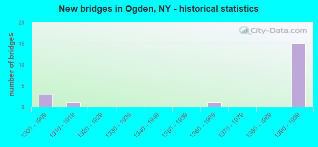
- New bridges - historical statistics
- 31900-1909
- 11910-1919
- 11960-1969
- 151990-1999
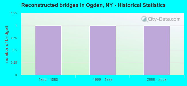
- Reconstructed bridges - Historical Statistics
- 11980-1989
- 11990-1999
- 12000-2009
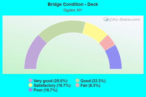
- Bridge Condition - Deck
- 25.0%Very good
- 33.3%Good
- 16.7%Satisfactory
- 8.3%Fair
- 16.7%Poor
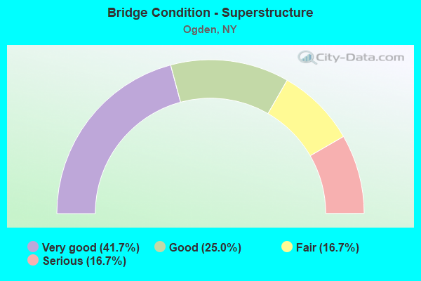
- Bridge Condition - Superstructure
- 41.7%Very good
- 25.0%Good
- 16.7%Fair
- 16.7%Serious
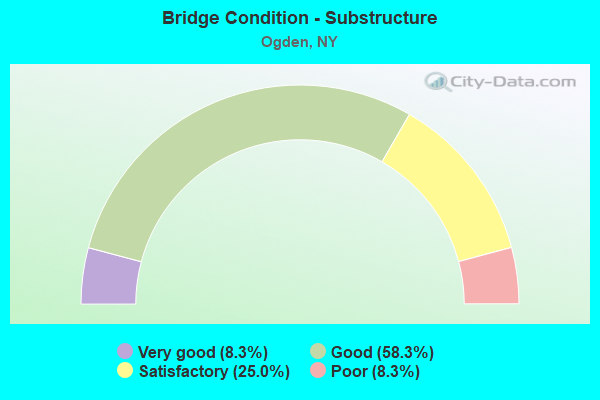
- Bridge Condition - Substructure
- 8.3%Very good
- 58.3%Good
- 25.0%Satisfactory
- 8.3%Poor
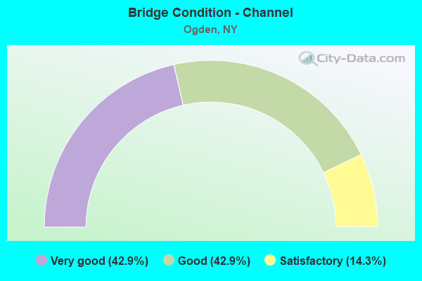
- Bridge Condition - Channel
- 42.9%Very good
- 42.9%Good
- 14.3%Satisfactory
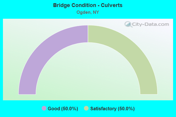
- Bridge Condition - Culverts
- 50.0%Good
- 50.0%Satisfactory
Find on map >> Show street view
Structure Number: 107469, Location: JCT CO RD 208 & SH 531 (Lat: 43.160228, Lng: -77.753847), Route carried "on" structure: County highway , Year Built: 1993, Status: Open, Structure Length: 6.52m (21.39ft), Average Daily Traffic: 11,951 (year 2018), Truck Traffic: 5%, Average Future Daily Traffic: 14,518 (year 2040), Design Load: HS 20, Features Intersected: 531 531 43012059 WB, RTE, Facility Carried by Structure: MANITOU ROAD
Minimum Vertical Clearance: 30+ m (98+ ft), Kilometerpoint: 2.381, Lanes on structure: 6, Lanes under structure: 4, Owner: State Highway Agency, Approaching Roadway Width: 22.9m (75.1ft), Material/Design: Steel continuous, Design/Construction: Stringer/Multi-beam, Number Of Spans In Main Unit: 2, Length of Maximum Span: 32.0m (105.0ft), Curb-To-Curb Width: 23.0m (75.5ft), Out-to-Out Width: 24.0m (78.7ft)
Condition: Deck: Satisfactory, Superstructure: Good, Substructure: Satisfactory, Operating Rating: 77.1 metric tons, Method Used To Determine Operating Rating: Load Factor (LF), Inventory Rating: 46.3 metric tons, Method Used To Determine Inventory Rating: Load Factor (LF), Structural Evaluation: Equal to present minimum criteria, Deck Geometry: Meets minimum limits, Underclear: Equal to present minimum criteria, Approach Roadway Alignment: Equal to present desirable criteria, Length Of Structure Improvement: 6.52m (21.39ft), Designated Inspection Frequency: Every 24 months, Inspection Date: March 2021, Bridge Improvement Cost: $3,944,000, Roadway Improvement Cost: $2,310,000, Total Project Cost: $6,254,000 ( Estimate for 2021), Deck Structure Type: Concrete Cast-file-Place, Wearing Surface/Protective System: Wearing Surface: Integral Concrete, Deck Protection: Epoxy Coated Reinforcing
Find on map >> Show street view
Structure Number: 1074701, Location: 2.6 MI E JCT SH259 &SH531 (Lat: 43.167044, Lng: -77.760936), Route carried "on" structure: State highway 531, Year Built: 1994, Status: Open, Structure Length: 3.51m (11.52ft), Average Daily Traffic: 14,017 (year 2019), Truck Traffic: 5%, Average Future Daily Traffic: 14,621 (year 2040), Design Load: HS 20, Features Intersected: LYELL ROAD-CR 117
Minimum Vertical Clearance: 30+ m (98+ ft), Kilometerpoint: 8.286, Lanes on structure: 2, Lanes under structure: 2, Base Highway Network: Yes, Owner: State Highway Agency, Approaching Roadway Width: 12.2m (40.0ft), Material/Design: Steel, Design/Construction: Stringer/Multi-beam, Number Of Spans In Main Unit: 1, Length of Maximum Span: 33.8m (110.9ft), Curb-To-Curb Width: 12.0m (39.4ft), Out-to-Out Width: 13.0m (42.7ft)
Condition: Deck: Good, Superstructure: Very good, Substructure: Very good, Operating Rating: 71.7 metric tons, Method Used To Determine Operating Rating: Load Factor (LF), Inventory Rating: 34.5 metric tons, Method Used To Determine Inventory Rating: Load Factor (LF), Structural Evaluation: Equal to present desirable criteria, Deck Geometry: Equal to present minimum criteria, Underclear: Somewhat better than minimum adequacy, Approach Roadway Alignment: Equal to present desirable criteria, Length Of Structure Improvement: 3.50m (11.48ft), Designated Inspection Frequency: Every 24 months, Inspection Date: April 2020, Bridge Improvement Cost: $1,350,000, Roadway Improvement Cost: $791,000, Total Project Cost: $2,141,000 ( Estimate for 2021), Deck Structure Type: Concrete Cast-file-Place, Wearing Surface/Protective System: Wearing Surface: Epoxy Overlay, Deck Protection: Epoxy Coated Reinforcing
Find on map >> Show street view
Structure Number: 1074702, Location: 2.6 MI E JCT SH259 &SH531 (Lat: 43.167044, Lng: -77.761214), Route carried "on" structure: State highway 531, Year Built: 1994, Status: Open, Structure Length: 3.51m (11.52ft), Average Daily Traffic: 14,017 (year 2019), Truck Traffic: 5%, Average Future Daily Traffic: 14,621 (year 2040), Design Load: HS 20, Features Intersected: LYELL ROAD-CR 117
Minimum Vertical Clearance: 30+ m (98+ ft), Kilometerpoint: 9.026, Lanes on structure: 2, Lanes under structure: 2, Base Highway Network: Yes, Owner: State Highway Agency, Approaching Roadway Width: 12.2m (40.0ft), Material/Design: Steel, Design/Construction: Stringer/Multi-beam, Number Of Spans In Main Unit: 1, Length of Maximum Span: 33.8m (110.9ft), Curb-To-Curb Width: 12.0m (39.4ft), Out-to-Out Width: 13.0m (42.7ft)
Condition: Deck: Very good, Superstructure: Good, Substructure: Good, Operating Rating: 71.7 metric tons, Method Used To Determine Operating Rating: Load Factor (LF), Inventory Rating: 34.5 metric tons, Method Used To Determine Inventory Rating: Load Factor (LF), Structural Evaluation: Better than present minimum criteria, Deck Geometry: Equal to present minimum criteria, Underclear: Somewhat better than minimum adequacy, Approach Roadway Alignment: Equal to present desirable criteria, Length Of Structure Improvement: 3.50m (11.48ft), Designated Inspection Frequency: Every 24 months, Inspection Date: April 2020, Bridge Improvement Cost: $1,367,000, Roadway Improvement Cost: $800,000, Total Project Cost: $2,167,000 ( Estimate for 2021), Deck Structure Type: Concrete Cast-file-Place, Wearing Surface/Protective System: Wearing Surface: Epoxy Overlay, Deck Protection: Epoxy Coated Reinforcing
Find on map >> Show street view
Structure Number: 107471, Location: 1.6 MI E JCT RTS 259& 531 (Lat: 43.175314, Lng: -77.774039), Route carried "on" structure: County highway , Year Built: 1993, Status: Open, Structure Length: 6.52m (21.39ft), Average Daily Traffic: 3,062 (year 2018), Truck Traffic: 5%, Average Future Daily Traffic: 3,788 (year 2040), Design Load: HS 20, Features Intersected: 531 531 43012041 WB, RTE, Facility Carried by Structure: GILLETT ROAD
Minimum Vertical Clearance: 30+ m (98+ ft), Kilometerpoint: 1.883, Lanes on structure: 2, Lanes under structure: 4, Owner: State Highway Agency, Approaching Roadway Width: 12.2m (40.0ft), Material/Design: Steel continuous, Design/Construction: Stringer/Multi-beam, Number Of Spans In Main Unit: 2, Length of Maximum Span: 32.0m (105.0ft), Curb-To-Curb Width: 12.0m (39.4ft), Out-to-Out Width: 13.0m (42.7ft)
Condition: Deck: Very good, Superstructure: Very good, Substructure: Good, Operating Rating: 66.2 metric tons, Method Used To Determine Operating Rating: Load Factor (LF), Inventory Rating: 39.9 metric tons, Method Used To Determine Inventory Rating: Load Factor (LF), Structural Evaluation: Better than present minimum criteria, Deck Geometry: Somewhat better than minimum adequacy, Underclear: Equal to present minimum criteria, Approach Roadway Alignment: Equal to present desirable criteria, Length Of Structure Improvement: 6.52m (21.39ft), Designated Inspection Frequency: Every 24 months, Inspection Date: April 2021, Bridge Improvement Cost: $2,074,000, Roadway Improvement Cost: $1,214,000, Total Project Cost: $3,288,000 ( Estimate for 2021), Deck Structure Type: Concrete Cast-file-Place, Wearing Surface/Protective System: Wearing Surface: Integral Concrete, Deck Protection: Epoxy Coated Reinforcing
Find on map >> Show street view
Structure Number: 107472, Location: 0.4 MI E OF JCT NY259&531 (Lat: 43.177853, Lng: -77.796519), Route carried "on" structure: State highway 531, Year Built: 1994, Status: Open, Structure Length: 0.67m (2.20ft), Average Daily Traffic: 28,034 (year 2019), Truck Traffic: 5%, Average Future Daily Traffic: 29,242 (year 2040), Design Load: HS 20, Features Intersected: NORTHRUP CREEK
Minimum Vertical Clearance: 30+ m (98+ ft), Kilometerpoint: 5.551, Lanes on structure: 4, Base Highway Network: Yes, Owner: State Highway Agency, Approaching Roadway Width: 24.4m (80.1ft), Skew: 20 degrees, Material/Design: Concrete, Design/Construction: Culvert, Number Of Spans In Main Unit: 1, Length of Maximum Span: 6.1m (20.0ft)
Condition: Channel: Good, Culverts: Satisfactory, Inventory Rating: 72.6 metric tons, Method Used To Determine Inventory Rating: Load Factor (LF), Structural Evaluation: Equal to present minimum criteria, Waterway Adequacy: Equal to present minimum criteria, Approach Roadway Alignment: Equal to present desirable criteria, Length Of Structure Improvement: 0.67m (2.20ft), Designated Inspection Frequency: Every 24 months, Inspection Date: April 2020, Bridge Improvement Cost: $562,000, Roadway Improvement Cost: $329,000, Total Project Cost: $891,000 ( Estimate for 2021), Wearing Surface/Protective System: Wearing Surface: Bituminous
Find on map >> Show street view
Structure Number: 1074731, Location: RT.531 W.B.OVER RTE 259 (Lat: 43.178733, Lng: -77.804397), Route carried "on" structure: State highway 531, Year Built: 1994, Status: Open, Structure Length: 4.88m (16.01ft), Average Daily Traffic: 9,040 (year 2020), Truck Traffic: 7%, Average Future Daily Traffic: 9,429 (year 2040), Design Load: HS 20, Features Intersected: RTE 259
Minimum Vertical Clearance: 30+ m (98+ ft), Kilometerpoint: 4.151, Lanes on structure: 2, Lanes under structure: 5, Base Highway Network: Yes, Owner: State Highway Agency, Approaching Roadway Width: 12.2m (40.0ft), Material/Design: Steel, Design/Construction: Stringer/Multi-beam, Number Of Spans In Main Unit: 1, Length of Maximum Span: 47.5m (155.8ft), Curb-To-Curb Width: 12.0m (39.4ft), Out-to-Out Width: 13.0m (42.7ft)
Condition: Deck: Good, Superstructure: Very good, Substructure: Good, Operating Rating: 67.1 metric tons, Method Used To Determine Operating Rating: Load Factor (LF), Inventory Rating: 39.9 metric tons, Method Used To Determine Inventory Rating: Load Factor (LF), Structural Evaluation: Better than present minimum criteria, Deck Geometry: Equal to present minimum criteria, Underclear: High priority of corrective action, Approach Roadway Alignment: Equal to present desirable criteria, Length Of Structure Improvement: 4.87m (15.98ft), Designated Inspection Frequency: Every 24 months, Inspection Date: May 2020, Bridge Improvement Cost: $1,675,000, Roadway Improvement Cost: $981,000, Total Project Cost: $2,657,000 ( Estimate for 2021), Deck Structure Type: Concrete Cast-file-Place, Wearing Surface/Protective System: Wearing Surface: Bituminous, Deck Protection: Epoxy Coated Reinforcing
Find on map >> Show street view
Structure Number: 1074732, Location: RT.531 E.B. OVER RTE 259 (Lat: 43.178531, Lng: -77.804408), Route carried "on" structure: State highway 531, Year Built: 1994, Status: Open, Structure Length: 4.88m (16.01ft), Average Daily Traffic: 14,017 (year 2019), Truck Traffic: 5%, Average Future Daily Traffic: 14,621 (year 2040), Design Load: HS 20, Features Intersected: RTE 259
Minimum Vertical Clearance: 30+ m (98+ ft), Kilometerpoint: 4.891, Lanes on structure: 2, Lanes under structure: 5, Base Highway Network: Yes, Owner: State Highway Agency, Approaching Roadway Width: 12.2m (40.0ft), Material/Design: Steel, Design/Construction: Stringer/Multi-beam, Number Of Spans In Main Unit: 1, Length of Maximum Span: 47.5m (155.8ft), Curb-To-Curb Width: 12.0m (39.4ft), Out-to-Out Width: 13.0m (42.7ft)
Condition: Deck: Good, Superstructure: Very good, Substructure: Good, Operating Rating: 67.1 metric tons, Method Used To Determine Operating Rating: Load Factor (LF), Inventory Rating: 39.9 metric tons, Method Used To Determine Inventory Rating: Load Factor (LF), Structural Evaluation: Better than present minimum criteria, Deck Geometry: Equal to present minimum criteria, Underclear: High priority of corrective action, Approach Roadway Alignment: Equal to present desirable criteria, Length Of Structure Improvement: 4.87m (15.98ft), Designated Inspection Frequency: Every 24 months, Inspection Date: May 2020, Bridge Improvement Cost: $1,675,000, Roadway Improvement Cost: $981,000, Total Project Cost: $2,657,000 ( Estimate for 2021), Deck Structure Type: Concrete Cast-file-Place, Wearing Surface/Protective System: Wearing Surface: Bituminous, Deck Protection: Epoxy Coated Reinforcing
Find on map >> Show street view
Structure Number: 107474, Location: .2 MI W JCT SH259 & SH531 (Lat: 43.179881, Lng: -77.814433), Route carried "on" structure: Bypass State highway 531, Year Built: 1994, Status: Open, Structure Length: 0.79m (2.59ft), Average Daily Traffic: 18,080 (year 2020), Truck Traffic: 7%, Average Future Daily Traffic: 18,859 (year 2040), Design Load: HS 20, Features Intersected: West Branch Northrup Cre
Minimum Vertical Clearance: 30+ m (98+ ft), Kilometerpoint: 4.055, Lanes on structure: 4, Base Highway Network: Yes, Owner: State Highway Agency, Approaching Roadway Width: 24.4m (80.1ft), Skew: 23 degrees, Material/Design: Concrete, Design/Construction: Culvert, Number Of Spans In Main Unit: 1, Length of Maximum Span: 7.6m (24.9ft)
Condition: Channel: Satisfactory, Culverts: Good, Operating Rating: 85.3 metric tons, Method Used To Determine Operating Rating: Load Factor (LF), Inventory Rating: 50.8 metric tons, Method Used To Determine Inventory Rating: Load Factor (LF), Structural Evaluation: Better than present minimum criteria, Waterway Adequacy: Meets minimum limits, Approach Roadway Alignment: Equal to present desirable criteria, Length Of Structure Improvement: 0.79m (2.59ft), Designated Inspection Frequency: Every 24 months, Inspection Date: April 2020, Bridge Improvement Cost: $676,000, Roadway Improvement Cost: $396,000, Total Project Cost: $1,072,000 ( Estimate for 2021), Wearing Surface/Protective System: Wearing Surface: Bituminous
Find on map >> Show street view
Structure Number: 331715, Location: 2 MI NW OF SPENCERPORT (Lat: 43.197533, Lng: -77.857900), Route carried "on" structure: County highway , Year Built: 1999, Status: Open, Structure Length: 1.13m (3.71ft), Average Daily Traffic: 1,507 (year 2020), Truck Traffic: 3%, Average Future Daily Traffic: 2,110 (year 2040), Design Load: HS 25 or greater, Features Intersected: SALMON CREEK, Facility Carried by Structure: Canal Road
Minimum Vertical Clearance: 30+ m (98+ ft), Kilometerpoint: 1.384, Lanes on structure: 2, Owner: County Highway Agency, Approaching Roadway Width: 6.7m (22.0ft), Material/Design: Concrete, Design/Construction: Frame, Number Of Spans In Main Unit: 1, Length of Maximum Span: 10.9m (35.8ft), Curb-To-Curb Width: 10.1m (33.1ft), Out-to-Out Width: 10.9m (35.8ft)
Condition: Deck: Good, Superstructure: Good, Substructure: Good, Channel: Good, Operating Rating: 80.4 metric tons, Method Used To Determine Operating Rating: Field evaluation and documented engineering judgment, Inventory Rating: 40.8 metric tons, Method Used To Determine Inventory Rating: Field evaluation and documented engineering judgment, Structural Evaluation: Better than present minimum criteria, Deck Geometry: Somewhat better than minimum adequacy, Waterway Adequacy: Better than present minimum criteria, Approach Roadway Alignment: Equal to present desirable criteria, Length Of Structure Improvement: 1.12m (3.67ft), Designated Inspection Frequency: Every 24 months, Inspection Date: June 2021, Bridge Improvement Cost: $364,000, Roadway Improvement Cost: $213,000, Total Project Cost: $577,000 ( Estimate for 2021), Wearing Surface/Protective System: Wearing Surface: Bituminous, Membrane: Other
Find on map >> Show street view
Structure Number: 33616, Location: 1.4 MI E OF SPENCERPORT (Lat: 43.188519, Lng: -77.773603), Route carried "on" structure: County highway , Year Built: 1969, Status: Open, Structure Length: 4.48m (14.70ft), Average Daily Traffic: 2,492 (year 2020), Truck Traffic: 4%, Average Future Daily Traffic: 3,083 (year 2040), Design Load: H 20, Features Intersected: EX-NY CENTRAL RR, Facility Carried by Structure: GILLETT ROAD
Minimum Vertical Clearance: 30+ m (98+ ft), Kilometerpoint: 3.347, Lanes on structure: 2, Owner: Railroad, Approaching Roadway Width: 11.9m (39.0ft), Skew: 1 degrees, Material/Design: Steel, Design/Construction: Stringer/Multi-beam, Number Of Spans In Main Unit: 3, Length of Maximum Span: 14.3m (46.9ft), Curb or Sidewalk Widths: Left: 1.6m (5.2ft), Right: 0.5m (1.6ft), Curb-To-Curb Width: 9.1m (29.9ft), Out-to-Out Width: 11.9m (39.0ft)
Condition: Deck: Fair, Superstructure: Fair, Substructure: Poor, Operating Rating: 57.0 metric tons, Method Used To Determine Operating Rating: Load and Resistance Factor Rating (LRFR) rating reported by rating factor(RF) method using HL-93 loadings, Inventory Rating: 44.1 metric tons, Method Used To Determine Inventory Rating: Load and Resistance Factor Rating (LRFR) rating reported by rating factor(RF) method using HL-93 loadings, Structural Evaluation: Meets minimum limits, Deck Geometry: Meets minimum limits, Approach Roadway Alignment: Equal to present minimum criteria, Length Of Structure Improvement: 4.48m (14.70ft), Designated Inspection Frequency: Every 24 months, Inspection Date: June 2021, Bridge Improvement Cost: $1,285,000, Roadway Improvement Cost: $753,000, Total Project Cost: $2,038,000 ( Estimate for 2021), Deck Structure Type: Concrete Cast-file-Place, Wearing Surface/Protective System: Wearing Surface: Integral Concrete
Find on map >> Show street view
Structure Number: 444314, Location: 1.4MI E JCT BARGE C + 259 (Lat: 43.190703, Lng: -77.773581), Route carried "on" structure: Other road , Year Built: 1909, Year Reconstructed: 1994, Status: Posted for load-capacity, Structure Length: 5.70m (18.70ft), Average Daily Traffic: 2,492 (year 2020), Truck Traffic: 4%, Average Future Daily Traffic: 3,083 (year 2040), Features Intersected: Erie Canal Heritage Trai, Facility Carried by Structure: GILLETT ROAD
Minimum Vertical Clearance: 4.19m (13.75ft), Kilometerpoint: 3.604, Lanes on structure: 1, Owner: State Highway Agency, Approaching Roadway Width: 4.3m (14.1ft), Navigation Control: Yes ( Vertical Clearance: 5.1m (16.7ft), Horizontal Clearance: 22.8m (74.8ft)), Material/Design: Steel, Design/Construction: Truss - Thru, Number Of Spans In Main Unit: 1, Number Of Approach Spans: 2, Length of Maximum Span: 45.1m (148.0ft), Curb-To-Curb Width: 4.5m (14.8ft), Out-to-Out Width: 5.0m (16.4ft)
Condition: Deck: Poor, Superstructure: Serious, Substructure: Satisfactory, Channel: Good, Operating Rating: 50.8 metric tons, Method Used To Determine Operating Rating: Field evaluation and documented engineering judgment, Inventory Rating: 22.0 metric tons, Method Used To Determine Inventory Rating: Field evaluation and documented engineering judgment, Structural Evaluation: High priority of corrective action, Deck Geometry: High priority of replacement, Waterway Adequacy: Superior to present desirable criteria, Approach Roadway Alignment: High priority of replacement, Length Of Structure Improvement: 5.69m (18.67ft), Designated Inspection Frequency: Every 12 months, Critical Feature Inspection Frequency: Every 12 months, Inspection Date: July 2021, Critical Feature Inspection Date: July 2021, Bridge Improvement Cost: $1,666,000, Roadway Improvement Cost: $975,000, Total Project Cost: $2,641,000 ( Estimate for 2021), Deck Structure Type: Concrete Cast-file-Place, Wearing Surface/Protective System: Wearing Surface: Integral Concrete, Deck Protection: Epoxy Coated Reinforcing
Find on map >> Show street view
Structure Number: 444316, Location: 1.2MI W JCT BARGE C + 259 (Lat: 43.195856, Lng: -77.823483), Route carried "on" structure: Other road , Year Built: 1909, Status: Posted for load, Structure Length: 5.94m (19.49ft), Average Daily Traffic: 828 (year 2016), Truck Traffic: 2%, Average Future Daily Traffic: 1,159 (year 2036), Features Intersected: Erie Canal Bike Path, ER, Facility Carried by Structure: TRIMMER ROAD
Minimum Vertical Clearance: 4.19m (13.75ft), Kilometerpoint: 0.998, Lanes on structure: 1, Owner: State Highway Agency, Approaching Roadway Width: 6.7m (22.0ft), Navigation Control: Yes ( Vertical Clearance: 999.9m (3,280.5ft), Horizontal Clearance: 22.8m (74.8ft)), Material/Design: Steel, Design/Construction: Truss - Thru, Number Of Spans In Main Unit: 1, Number Of Approach Spans: 2, Length of Maximum Span: 45.1m (148.0ft), Curb-To-Curb Width: 4.5m (14.8ft), Out-to-Out Width: 5.0m (16.4ft)
Condition: Deck: Satisfactory, Superstructure: Fair, Substructure: Good, Channel: Very good, Operating Rating: 20.9 metric tons, Method Used To Determine Operating Rating: Load Factor (LF), Inventory Rating: 11.8 metric tons, Method Used To Determine Inventory Rating: Load Factor (LF), Structural Evaluation: High priority of corrective action, Deck Geometry: High priority of replacement, Waterway Adequacy: Superior to present desirable criteria, Approach Roadway Alignment: High priority of replacement, Bridge Posting: Required (Relationship of Operating Rating to Maximum Legal Load: > 39.9% below), Length Of Structure Improvement: 5.94m (19.49ft), Designated Inspection Frequency: Every 12 months, Critical Feature Inspection Frequency: Every 12 months, Inspection Date: June 2021, Critical Feature Inspection Date: June 2021, Bridge Improvement Cost: $2,182,000, Roadway Improvement Cost: $1,278,000, Total Project Cost: $3,460,000 ( Estimate for 2021), Wearing Surface/Protective System: Wearing Surface: Integral Concrete
Find on map >> Show street view
Structure Number: 444318, Location: 1.4 MI E JCT BG CNL&SH260 (Lat: 43.202714, Lng: -77.872667), Route carried "on" structure: County highway , Year Built: 1908, Year Reconstructed: 2003, Status: Posted for load, Structure Length: 5.70m (18.70ft), Average Daily Traffic: 1,020 (year 2020), Truck Traffic: 4%, Average Future Daily Traffic: 1,428 (year 2040), Features Intersected: Canalway Trail, ERIE CAN, Facility Carried by Structure: CR 244- Gallup Rd
Minimum Vertical Clearance: 4.27m (14.01ft), Kilometerpoint: 0.563, Lanes on structure: 1, Owner: State Highway Agency, Approaching Roadway Width: 7.6m (24.9ft), Navigation Control: Yes ( Vertical Clearance: 999.9m (3,280.5ft), Horizontal Clearance: 22.8m (74.8ft)), Material/Design: Steel, Design/Construction: Truss - Thru, Number Of Spans In Main Unit: 1, Number Of Approach Spans: 2, Length of Maximum Span: 45.1m (148.0ft), Curb-To-Curb Width: 4.5m (14.8ft), Out-to-Out Width: 5.0m (16.4ft)
Condition: Deck: Poor, Superstructure: Serious, Substructure: Satisfactory, Channel: Very good, Operating Rating: 10.0 metric tons, Method Used To Determine Operating Rating: Load Factor (LF), Inventory Rating: 5.4 metric tons, Method Used To Determine Inventory Rating: Load Factor (LF), Structural Evaluation: High priority of corrective action, Deck Geometry: High priority of replacement, Waterway Adequacy: Equal to present desirable criteria, Approach Roadway Alignment: Equal to present minimum criteria, Bridge Posting: Required (Relationship of Operating Rating to Maximum Legal Load: > 39.9% below), Length Of Structure Improvement: 5.69m (18.67ft), Designated Inspection Frequency: Every 12 months, Critical Feature Inspection Frequency: Every 12 months, Inspection Date: July 2021, Critical Feature Inspection Date: July 2021, Bridge Improvement Cost: $2,040,000, Roadway Improvement Cost: $1,194,000, Total Project Cost: $3,234,000 ( Estimate for 2021), Wearing Surface/Protective System: Wearing Surface: Integral Concrete
Find on map >> Show street view
Structure Number: 444359, Location: .4 MI N JCT SH 31 & SH 36 (Lat: 43.195583, Lng: -77.853828), Route carried "on" structure: County highway , Year Built: 1912, Year Reconstructed: 2007, Status: Open, Structure Length: 4.33m (14.21ft), Average Daily Traffic: 3,077 (year 2019), Truck Traffic: 5%, Average Future Daily Traffic: 3,807 (year 2040), Design Load: HS 20, Features Intersected: ERIE CANAL, Facility Carried by Structure: WASHINGTON STREET
Minimum Vertical Clearance: 30+ m (98+ ft), Kilometerpoint: 0.805, Lanes on structure: 2, Owner: State Highway Agency, Approaching Roadway Width: 6.1m (20.0ft), Navigation Control: Yes ( Vertical Clearance: 999.9m (3,280.5ft), Horizontal Clearance: 22.8m (74.8ft)), Material/Design: Steel, Design/Construction: Movable - Lift, Number Of Spans In Main Unit: 1, Number Of Approach Spans: 2, Length of Maximum Span: 36.2m (118.8ft), Curb or Sidewalk Widths: Left: 1.7m (5.6ft), Right: 1.7m (5.6ft), Curb-To-Curb Width: 5.7m (18.7ft), Out-to-Out Width: 6.3m (20.7ft)
Condition: Deck: Very good, Superstructure: Very good, Substructure: Good, Channel: Very good, Operating Rating: 65.3 metric tons, Method Used To Determine Operating Rating: Load Factor (LF), Inventory Rating: 39.0 metric tons, Method Used To Determine Inventory Rating: Load Factor (LF), Structural Evaluation: Better than present minimum criteria, Deck Geometry: High priority of replacement, Waterway Adequacy: Equal to present desirable criteria, Approach Roadway Alignment: Equal to present minimum criteria, Length Of Structure Improvement: 4.32m (14.17ft), Designated Inspection Frequency: Every 24 months, Critical Feature Inspection Frequency: Every 24 months, Inspection Date: August 2021, Critical Feature Inspection Date: August 2021, Bridge Improvement Cost: $3,875,000, Roadway Improvement Cost: $2,269,000, Total Project Cost: $6,144,000 ( Estimate for 2021), Deck Structure Type: Concrete Cast-file-Place, Wearing Surface/Protective System: Wearing Surface: Integral Concrete, Deck Protection: Epoxy Coated Reinforcing
Find on map >> Show street view
Structure Number: 107469, Location: JCT CO RD 208 & SH 531 (Lat: 43.160228, Lng: -77.753847), Route carried "under" structure: State highway 531, Year Built: 1993, Structure Length: 0. m, Average Daily Traffic: 1,000 (year 2021), Features Intersected: 531 531 43012059 WB, RTE, Facility Carried by Structure: MANITOU ROAD
Minimum Vertical Clearance: 4.62m (15.16ft), Kilometerpoint: 2.574, Lanes on structure: 6, Lanes under structure: 2, Material/Design: Steel continuous, Design/Construction: Stringer/Multi-beam, Length of Maximum Span: 32.0m (105.0ft)
Find on map >> Show street view
Structure Number: 1074701, Location: 2.6 MI E JCT SH259 &SH531 (Lat: 43.167044, Lng: -77.760936), Route carried "under" structure: County highway , Year Built: 1994, Structure Length: 0. m, Average Daily Traffic: 1,015 (year 2019), Truck Traffic: 4%, Features Intersected: LYELL ROAD-CR 117, Facility Carried by Structure: RTE 531
Minimum Vertical Clearance: 4.52m (14.83ft), Kilometerpoint: 1.046, Lanes on structure: 2, Lanes under structure: 2, Material/Design: Steel, Design/Construction: Stringer/Multi-beam, Length of Maximum Span: 33.8m (110.9ft)
Find on map >> Show street view
Structure Number: 1074702, Location: 2.6 MI E JCT SH259 &SH531 (Lat: 43.167044, Lng: -77.761214), Route carried "under" structure: County highway , Year Built: 1994, Structure Length: 0. m, Average Daily Traffic: 1,184 (year 2015), Truck Traffic: 3%, Features Intersected: LYELL ROAD-CR 117, Facility Carried by Structure: RTE 531
Minimum Vertical Clearance: 4.60m (15.09ft), Kilometerpoint: 0.000, Lanes on structure: 2, Lanes under structure: 2, Material/Design: Steel, Design/Construction: Stringer/Multi-beam, Length of Maximum Span: 33.8m (110.9ft)
Find on map >> Show street view
Structure Number: 107471, Location: 1.6 MI E JCT RTS 259& 531 (Lat: 43.175314, Lng: -77.774039), Route carried "under" structure: State highway 531, Year Built: 1993, Structure Length: 0. m, Average Daily Traffic: 8,735 (year 1993), Features Intersected: 531 531 43012041 WB, RTE, Facility Carried by Structure: GILLETT ROAD
Minimum Vertical Clearance: 4.60m (15.09ft), Kilometerpoint: 5.471, Lanes on structure: 2, Lanes under structure: 2, Material/Design: Steel continuous, Design/Construction: Stringer/Multi-beam, Length of Maximum Span: 32.0m (105.0ft)
Find on map >> Show street view
Structure Number: 1074731, Location: RT.531 W.B.OVER RTE 259 (Lat: 43.178733, Lng: -77.804397), Route carried "under" structure: State highway 259, Year Built: 1994, Structure Length: 0. m, Average Daily Traffic: 6,899 (year 2018), Truck Traffic: 3%, Features Intersected: RTE 259, Facility Carried by Structure: RTE 531
Minimum Vertical Clearance: 4.72m (15.49ft), Kilometerpoint: 9.590, Lanes on structure: 2, Lanes under structure: 5, Material/Design: Steel, Design/Construction: Stringer/Multi-beam, Length of Maximum Span: 47.5m (155.8ft)
Find on map >> Show street view
Structure Number: 1074732, Location: RT.531 E.B. OVER RTE 259 (Lat: 43.178531, Lng: -77.804408), Route carried "under" structure: State highway 259, Year Built: 1994, Structure Length: 0. m, Average Daily Traffic: 4,355 (year 2018), Truck Traffic: 4%, Features Intersected: RTE 259, Facility Carried by Structure: RTE 531
Minimum Vertical Clearance: 4.55m (14.93ft), Kilometerpoint: 9.557, Lanes on structure: 2, Lanes under structure: 5, Material/Design: Steel, Design/Construction: Stringer/Multi-beam, Length of Maximum Span: 47.5m (155.8ft)