Bridge Statistics for Ohatchee, Alabama (AL)
Condition, Traffic, Stress, Structural Evaluation, Project Costs
- National Bridge Inventory (NBI) Statistics
- 23Number of bridges
- 328ft / 100mTotal length
- $30,159,000Total costs
- 67,608Total average daily traffic
- 7,930Total average daily truck traffic
- National Bridge Inventory (NBI) Registered Bridges for Ohatchee
- No street view available for this location
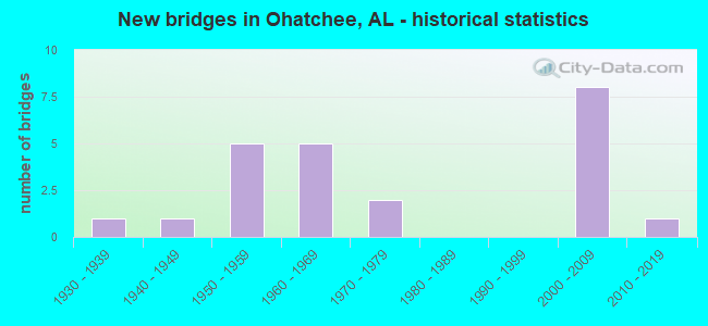
- New bridges - historical statistics
- 11930-1939
- 11940-1949
- 51950-1959
- 51960-1969
- 21970-1979
- 82000-2009
- 12010-2019


- Bridge Condition - Deck
- 25.0%Very good
- 16.7%Good
- 16.7%Satisfactory
- 33.3%Fair
- 8.3%Poor

- Bridge Condition - Superstructure
- 25.0%Very good
- 33.3%Good
- 33.3%Satisfactory
- 8.3%Fair

- Bridge Condition - Substructure
- 25.0%Very good
- 41.7%Good
- 33.3%Fair

- Bridge Condition - Channel
- 36.8%Very good
- 15.8%Good
- 31.6%Satisfactory
- 15.8%Fair

- Bridge Condition - Culverts
- 10.0%Excellent
- 20.0%Very good
- 30.0%Good
- 30.0%Satisfactory
- 10.0%Fair
Find on map >> Show street view
Structure Number: 1892, Location: 0.1 MI W FRANCISO (Lat: 34.986667, Lng: -86.250000), Route carried "on" structure: County highway , Year Built: 1979, Status: Open, Structure Length: 0.73m (2.40ft), Average Daily Traffic: 15 (year 1986), Truck Traffic: 2%, Average Future Daily Traffic: 43 (year 2040), Design Load: H 10, Features Intersected: PIGEON CREEK, Facility Carried by Structure: COUNTY ROAD 546
Minimum Vertical Clearance: 30+ m (98+ ft), Kilometerpoint: 0.010, Lanes on structure: 1, Owner: County Highway Agency, Approaching Roadway Width: 4.3m (14.1ft), Material/Design: Concrete, Design/Construction: Channel Beam, Number Of Spans In Main Unit: 1, Length of Maximum Span: 7.3m (24.0ft), Curb-To-Curb Width: 3.7m (12.1ft), Out-to-Out Width: 3.7m (12.1ft)
Condition: Deck: Satisfactory, Superstructure: Satisfactory, Substructure: Fair, Channel: Fair, Operating Rating: 61.6 metric tons, Method Used To Determine Operating Rating: Load Factor (LF), Inventory Rating: 37.1 metric tons, Method Used To Determine Inventory Rating: Load Factor (LF), Structural Evaluation: Somewhat better than minimum adequacy, Deck Geometry: Meets minimum limits, Waterway Adequacy: Better than present minimum criteria, Approach Roadway Alignment: Somewhat better than minimum adequacy, Length Of Structure Improvement: 1.38m (4.53ft), Designated Inspection Frequency: Every 24 months, Inspection Date: Febuary 2022, Bridge Improvement Cost: $113,000, Roadway Improvement Cost: $11,000, Total Project Cost: $124,000 ( Estimate for 2022), Deck Structure Type: Concrete Precast Panels
Find on map >> Show street view
Structure Number: 203, Location: GRAYTON RD. (Lat: 33.798086, Lng: -85.979225), Route carried "on" structure: County highway 66, Year Built: 1939, Status: Posted for load, Structure Length: 4.15m (13.62ft), Average Daily Traffic: 745 (year 1993), Truck Traffic: 3%, Average Future Daily Traffic: 1,015 (year 2039), Features Intersected: OHATCHEE CREEK, Facility Carried by Structure: Grayton Rd.
Minimum Vertical Clearance: 30+ m (98+ ft), Kilometerpoint: 0.010, Lanes on structure: 2, Owner: County Highway Agency, Approaching Roadway Width: 6.7m (22.0ft), Material/Design: Steel, Design/Construction: Stringer/Multi-beam, Number Of Spans In Main Unit: 5, Length of Maximum Span: 16.8m (55.1ft), Curb-To-Curb Width: 6.1m (20.0ft), Out-to-Out Width: 6.7m (22.0ft)
Condition: Deck: Poor, Superstructure: Fair, Substructure: Fair, Channel: Satisfactory, Operating Rating: 12.2 metric tons, Method Used To Determine Operating Rating: Allowable Stress (AS), Inventory Rating: 7.2 metric tons, Method Used To Determine Inventory Rating: Allowable Stress (AS), Structural Evaluation: High priority of replacement, Deck Geometry: High priority of corrective action, Waterway Adequacy: Better than present minimum criteria, Approach Roadway Alignment: Somewhat better than minimum adequacy, Bridge Posting: Required (Relationship of Operating Rating to Maximum Legal Load: > 39.9% below), Length Of Structure Improvement: 5.12m (16.80ft), Designated Inspection Frequency: Every 24 months, Other Special Inspection Frequency: Every 12 months, Inspection Date: October 2020, Other Special Inspection Date: October 2021, Bridge Improvement Cost: $772,000, Roadway Improvement Cost: $77,000, Total Project Cost: $849,000 ( Estimate for 2022), Deck Structure Type: Concrete Cast-file-Place
Find on map >> Show street view
Structure Number: 5991, Location: 3.7 MI N TALLADEGA CO LIN (Lat: 33.724389, Lng: -86.053294), Route carried "on" structure: State highway 77, Year Built: 1957, Status: Open, Structure Length: 12.44m (40.81ft), Average Daily Traffic: 7,170 (year 2019), Truck Traffic: 14%, Average Future Daily Traffic: 10,038 (year 2039), Design Load: H 20, Features Intersected: CANE CREEK
Minimum Vertical Clearance: 30+ m (98+ ft), Kilometerpoint: 138.581, Lanes on structure: 2, Base Highway Network: Yes, Owner: State Highway Agency, Approaching Roadway Width: 12.2m (40.0ft), Material/Design: Concrete, Design/Construction: Tee Beam, Number Of Spans In Main Unit: 12, Length of Maximum Span: 10.4m (34.1ft), Curb or Sidewalk Widths: Left: 0.5m (1.6ft), Right: 0.5m (1.6ft), Curb-To-Curb Width: 8.4m (27.6ft), Out-to-Out Width: 10.0m (32.8ft)
Condition: Deck: Fair, Superstructure: Satisfactory, Substructure: Fair, Channel: Fair, Operating Rating: 46.2 metric tons, Method Used To Determine Operating Rating: Load Factor (LF), Inventory Rating: 27.8 metric tons, Method Used To Determine Inventory Rating: Load Factor (LF), Structural Evaluation: Somewhat better than minimum adequacy, Deck Geometry: High priority of corrective action, Waterway Adequacy: Equal to present minimum criteria, Approach Roadway Alignment: Equal to present desirable criteria, Length Of Structure Improvement: 13.28m (43.57ft), Designated Inspection Frequency: Every 24 months, Underwater Inspection Frequency: Every 24 months, Inspection Date: April 2021, Underwater Inspection Date: September 2020, Bridge Improvement Cost: $2,914,000, Roadway Improvement Cost: $291,000, Total Project Cost: $3,205,000 ( Estimate for 2022), Deck Structure Type: Concrete Cast-file-Place
Find on map >> Show street view
Structure Number: 6349, Location: 1 MI SO JCT SR 144 (Lat: 33.769222, Lng: -86.041044), Route carried "on" structure: State highway 77, Year Built: 1958, Status: Open, Structure Length: 4.57m (14.99ft), Average Daily Traffic: 8,150 (year 2018), Truck Traffic: 20%, Average Future Daily Traffic: 11,410 (year 2038), Design Load: HS 20, Features Intersected: ATN R/R
Minimum Vertical Clearance: 30+ m (98+ ft), Kilometerpoint: 143.766, Lanes on structure: 2, Base Highway Network: Yes, Owner: State Highway Agency, Approaching Roadway Width: 12.2m (40.0ft), Material/Design: Concrete, Design/Construction: Tee Beam, Number Of Spans In Main Unit: 3, Length of Maximum Span: 15.2m (49.9ft), Curb or Sidewalk Widths: Left: 0.5m (1.6ft), Right: 0.5m (1.6ft), Curb-To-Curb Width: 8.5m (27.9ft), Out-to-Out Width: 9.4m (30.8ft)
Condition: Deck: Fair, Superstructure: Good, Substructure: Good, Operating Rating: 36.6 metric tons, Method Used To Determine Operating Rating: Load Factor (LF), Inventory Rating: 22.0 metric tons, Method Used To Determine Inventory Rating: Load Factor (LF), Structural Evaluation: Somewhat better than minimum adequacy, Deck Geometry: High priority of replacement, Underclear: Meets minimum limits, Approach Roadway Alignment: Better than present minimum criteria, Length Of Structure Improvement: 5.56m (18.24ft), Designated Inspection Frequency: Every 24 months, Inspection Date: June 2020, Bridge Improvement Cost: $1,145,000, Roadway Improvement Cost: $115,000, Total Project Cost: $1,260,000 ( Estimate for 2022), Deck Structure Type: Concrete Cast-file-Place
Find on map >> Show street view
Structure Number: 635, Location: 0.6 MI NO JCT SR 144 (Lat: 33.789544, Lng: -86.035442), Route carried "on" structure: State highway 77, Year Built: 1958, Status: Open, Structure Length: 0.63m (2.07ft), Average Daily Traffic: 9,017 (year 2019), Truck Traffic: 13%, Average Future Daily Traffic: 12,624 (year 2039), Design Load: HS 20, Features Intersected: BRANCH
Minimum Vertical Clearance: 30+ m (98+ ft), Kilometerpoint: 146.225, Lanes on structure: 2, Base Highway Network: Yes, Owner: State Highway Agency, Approaching Roadway Width: 11.3m (37.1ft), Material/Design: Concrete, Design/Construction: Culvert, Number Of Spans In Main Unit: 2, Length of Maximum Span: 3.0m (9.8ft)
Condition: Channel: Satisfactory, Culverts: Satisfactory, Operating Rating: 88.9 metric tons, Method Used To Determine Operating Rating: Load Factor (LF), Inventory Rating: 88.9 metric tons, Method Used To Determine Inventory Rating: Load Factor (LF), Structural Evaluation: Equal to present minimum criteria, Waterway Adequacy: Equal to present minimum criteria, Approach Roadway Alignment: Equal to present desirable criteria, Length Of Structure Improvement: 1.24m (4.07ft), Designated Inspection Frequency: Every 24 months, Inspection Date: April 2021, Bridge Improvement Cost: $617,000, Roadway Improvement Cost: $62,000, Total Project Cost: $679,000 ( Estimate for 2022)
Find on map >> Show street view
Structure Number: 6351, Location: 2.3 MI NO JCT SR 144 (Lat: 33.815000, Lng: -86.036667), Route carried "on" structure: State highway 77, Year Built: 1958, Status: Open, Structure Length: 1.58m (5.18ft), Average Daily Traffic: 9,017 (year 2019), Truck Traffic: 13%, Average Future Daily Traffic: 12,624 (year 2039), Design Load: HS 20, Features Intersected: OTTERY CREEK
Minimum Vertical Clearance: 30+ m (98+ ft), Kilometerpoint: 148.938, Lanes on structure: 2, Base Highway Network: Yes, Owner: State Highway Agency, Approaching Roadway Width: 15.2m (49.9ft), Material/Design: Concrete, Design/Construction: Culvert, Number Of Spans In Main Unit: 4, Length of Maximum Span: 3.7m (12.1ft)
Condition: Channel: Satisfactory, Culverts: Satisfactory, Operating Rating: 88.9 metric tons, Method Used To Determine Operating Rating: Load Factor (LF), Inventory Rating: 88.9 metric tons, Method Used To Determine Inventory Rating: Load Factor (LF), Structural Evaluation: Equal to present minimum criteria, Waterway Adequacy: Equal to present minimum criteria, Approach Roadway Alignment: Equal to present desirable criteria, Length Of Structure Improvement: 2.26m (7.41ft), Designated Inspection Frequency: Every 24 months, Underwater Inspection Frequency: Every 24 months, Inspection Date: September 2020, Underwater Inspection Date: September 2020, Bridge Improvement Cost: $627,000, Roadway Improvement Cost: $63,000, Total Project Cost: $690,000 ( Estimate for 2022)
Find on map >> Show street view
Structure Number: 8018, Location: 2.6 MI EAST JCT SR 77 (Lat: 33.776386, Lng: -85.994689), Route carried "on" structure: State highway 144, Year Built: 1963, Status: Open, Structure Length: 1.31m (4.30ft), Average Daily Traffic: 4,339 (year 2020), Truck Traffic: 4%, Average Future Daily Traffic: 6,075 (year 2040), Design Load: H 20, Features Intersected: COKER BRANCH
Minimum Vertical Clearance: 30+ m (98+ ft), Kilometerpoint: 33.365, Lanes on structure: 2, Owner: State Highway Agency, Approaching Roadway Width: 8.5m (27.9ft), Skew: 3 degrees, Material/Design: Concrete, Design/Construction: Culvert, Number Of Spans In Main Unit: 3, Length of Maximum Span: 4.2m (13.8ft)
Condition: Channel: Satisfactory, Culverts: Satisfactory, Operating Rating: 88.9 metric tons, Method Used To Determine Operating Rating: Load Factor (LF), Inventory Rating: 88.9 metric tons, Method Used To Determine Inventory Rating: Load Factor (LF), Structural Evaluation: Equal to present minimum criteria, Waterway Adequacy: Equal to present minimum criteria, Approach Roadway Alignment: Equal to present desirable criteria, Length Of Structure Improvement: 1.98m (6.50ft), Designated Inspection Frequency: Every 24 months, Inspection Date: January 2022, Bridge Improvement Cost: $1,123,000, Roadway Improvement Cost: $112,000, Total Project Cost: $1,235,000 ( Estimate for 2022)
Find on map >> Show street view
Structure Number: 8275, Location: WARRIOR RD. (Lat: 33.786219, Lng: -85.998294), Route carried "on" structure: County highway 15, Year Built: 1964, Status: Posted for load, Structure Length: 8.29m (27.20ft), Average Daily Traffic: 688 (year 2015), Truck Traffic: 1%, Average Future Daily Traffic: 1,129 (year 2040), Design Load: H 15, Features Intersected: OHATCHEE CREEK, Facility Carried by Structure: OHATCHEE
Minimum Vertical Clearance: 30+ m (98+ ft), Kilometerpoint: 0.010, Lanes on structure: 2, Owner: County Highway Agency, Approaching Roadway Width: 9.8m (32.2ft), Material/Design: Concrete, Design/Construction: Tee Beam, Number Of Spans In Main Unit: 8, Length of Maximum Span: 10.4m (34.1ft), Curb-To-Curb Width: 7.3m (24.0ft), Out-to-Out Width: 8.2m (26.9ft)
Condition: Deck: Good, Superstructure: Satisfactory, Substructure: Good, Channel: Good, Operating Rating: 35.1 metric tons, Method Used To Determine Operating Rating: Load Factor (LF), Inventory Rating: 21.0 metric tons, Method Used To Determine Inventory Rating: Load Factor (LF), Structural Evaluation: Somewhat better than minimum adequacy, Deck Geometry: Meets minimum limits, Approach Roadway Alignment: Equal to present minimum criteria, Bridge Posting: Required (Relationship of Operating Rating to Maximum Legal Load: 0.1 - 9.9% below), Length Of Structure Improvement: 9.29m (30.48ft), Designated Inspection Frequency: Every 24 months, Other Special Inspection Frequency: Every 12 months, Inspection Date: January 2021, Other Special Inspection Date: January 2022, Bridge Improvement Cost: $1,656,000, Roadway Improvement Cost: $166,000, Total Project Cost: $1,822,000 ( Estimate for 2022), Deck Structure Type: Concrete Cast-file-Place
Find on map >> Show street view
Structure Number: 8398, Location: 6.4 MI N TALLADEGA CO LIN (Lat: 33.761611, Lng: -86.043611), Route carried "on" structure: State highway 77, Year Built: 1964, Status: Open, Structure Length: 15.91m (52.20ft), Average Daily Traffic: 8,150 (year 2018), Truck Traffic: 20%, Average Future Daily Traffic: 11,410 (year 2038), Design Load: H 20, Features Intersected: OHATCHEE CREEK
Minimum Vertical Clearance: 30+ m (98+ ft), Kilometerpoint: 142.881, Lanes on structure: 2, Base Highway Network: Yes, Owner: State Highway Agency, Approaching Roadway Width: 7.3m (24.0ft), Material/Design: Steel continuous, Design/Construction: Stringer/Multi-beam, Number Of Spans In Main Unit: 13, Length of Maximum Span: 18.3m (60.0ft), Curb or Sidewalk Widths: Left: 0.2m (0.7ft), Right: 0.2m (0.7ft), Curb-To-Curb Width: 8.5m (27.9ft), Out-to-Out Width: 9.4m (30.8ft)
Condition: Deck: Satisfactory, Superstructure: Satisfactory, Substructure: Fair, Channel: Fair, Operating Rating: 42.5 metric tons, Method Used To Determine Operating Rating: Load Factor (LF), Inventory Rating: 25.4 metric tons, Method Used To Determine Inventory Rating: Load Factor (LF), Structural Evaluation: Somewhat better than minimum adequacy, Deck Geometry: Meets minimum limits, Waterway Adequacy: Equal to present minimum criteria, Approach Roadway Alignment: Better than present minimum criteria, Length Of Structure Improvement: 16.66m (54.66ft), Designated Inspection Frequency: Every 24 months, Underwater Inspection Frequency: Every 24 months, Inspection Date: September 2020, Underwater Inspection Date: September 2020, Bridge Improvement Cost: $3,428,000, Roadway Improvement Cost: $343,000, Total Project Cost: $3,771,000 ( Estimate for 2022), Deck Structure Type: Concrete Cast-file-Place
Find on map >> Show street view
Structure Number: 9741, Location: 1.6 MI EAST JCT SR 77 (Lat: 33.782028, Lng: -86.008361), Route carried "on" structure: State highway 144, Year Built: 1968, Status: Open, Structure Length: 5.79m (19.00ft), Average Daily Traffic: 4,349 (year 2018), Truck Traffic: 5%, Average Future Daily Traffic: 6,089 (year 2038), Design Load: HS 20, Features Intersected: ATN RAILROAD
Minimum Vertical Clearance: 30+ m (98+ ft), Kilometerpoint: 31.862, Lanes on structure: 2, Base Highway Network: Yes, Owner: State Highway Agency, Approaching Roadway Width: 12.2m (40.0ft), Skew: 3 degrees, Material/Design: Steel, Design/Construction: Stringer/Multi-beam, Number Of Spans In Main Unit: 1, Number Of Approach Spans: 4, Length of Maximum Span: 21.3m (69.9ft), Curb or Sidewalk Widths: Left: 0.4m (1.3ft), Right: 0.4m (1.3ft), Curb-To-Curb Width: 8.5m (27.9ft), Out-to-Out Width: 9.4m (30.8ft)
Condition: Deck: Fair, Superstructure: Good, Substructure: Good, Operating Rating: 46.1 metric tons, Method Used To Determine Operating Rating: Load Factor (LF), Inventory Rating: 27.7 metric tons, Method Used To Determine Inventory Rating: Load Factor (LF), Structural Evaluation: Equal to present minimum criteria, Deck Geometry: Meets minimum limits, Approach Roadway Alignment: Better than present minimum criteria, Length Of Structure Improvement: 6.83m (22.41ft), Designated Inspection Frequency: Every 24 months, Inspection Date: June 2020, Bridge Improvement Cost: $1,405,000, Roadway Improvement Cost: $141,000, Total Project Cost: $1,546,000 ( Estimate for 2022), Deck Structure Type: Concrete Cast-file-Place
Find on map >> Show street view
Structure Number: 9742, Location: 2.1 MI EAST JCT SR 77 (Lat: 33.779211, Lng: -86.001542), Route carried "on" structure: State highway 144, Year Built: 1968, Status: Open, Structure Length: 11.34m (37.20ft), Average Daily Traffic: 4,998 (year 2018), Truck Traffic: 7%, Average Future Daily Traffic: 6,997 (year 2038), Design Load: HS 20, Features Intersected: OHATCHEE CREEK
Minimum Vertical Clearance: 30+ m (98+ ft), Kilometerpoint: 32.559, Lanes on structure: 2, Base Highway Network: Yes, Owner: State Highway Agency, Approaching Roadway Width: 12.2m (40.0ft), Skew: 3 degrees, Material/Design: Steel continuous, Design/Construction: Stringer/Multi-beam, Number Of Spans In Main Unit: 3, Number Of Approach Spans: 5, Length of Maximum Span: 24.4m (80.1ft), Curb or Sidewalk Widths: Left: 0.5m (1.6ft), Right: 0.5m (1.6ft), Curb-To-Curb Width: 8.5m (27.9ft), Out-to-Out Width: 9.4m (30.8ft)
Condition: Deck: Fair, Superstructure: Good, Substructure: Good, Channel: Satisfactory, Operating Rating: 43.3 metric tons, Method Used To Determine Operating Rating: Load Factor (LF), Inventory Rating: 25.9 metric tons, Method Used To Determine Inventory Rating: Load Factor (LF), Structural Evaluation: Equal to present minimum criteria, Deck Geometry: Meets minimum limits, Waterway Adequacy: Equal to present minimum criteria, Approach Roadway Alignment: Equal to present desirable criteria, Length Of Structure Improvement: 12.22m (40.09ft), Designated Inspection Frequency: Every 24 months, Inspection Date: June 2020, Bridge Improvement Cost: $2,513,000, Roadway Improvement Cost: $251,000, Total Project Cost: $2,764,000 ( Estimate for 2022), Deck Structure Type: Concrete Cast-file-Place
Find on map >> Show street view
Structure Number: 11001, Location: 0.7MI E ST CLAIR CO LINE (Lat: 33.783972, Lng: -86.039775), Route carried "on" structure: State highway 144, Year Built: 1973, Status: Open, Structure Length: 0.94m (3.08ft), Average Daily Traffic: 2,980 (year 2020), Truck Traffic: 5%, Average Future Daily Traffic: 4,172 (year 2040), Design Load: HS 20, Features Intersected: BRANCH
Minimum Vertical Clearance: 30+ m (98+ ft), Kilometerpoint: 28.460, Lanes on structure: 2, Owner: State Highway Agency, Approaching Roadway Width: 7.3m (24.0ft), Material/Design: Concrete, Design/Construction: Culvert, Number Of Spans In Main Unit: 3, Length of Maximum Span: 3.0m (9.8ft)
Condition: Channel: Satisfactory, Culverts: Fair, Operating Rating: 88.9 metric tons, Method Used To Determine Operating Rating: Load Factor (LF), Inventory Rating: 88.9 metric tons, Method Used To Determine Inventory Rating: Load Factor (LF), Structural Evaluation: Somewhat better than minimum adequacy, Waterway Adequacy: Somewhat better than minimum adequacy, Approach Roadway Alignment: Equal to present desirable criteria, Length Of Structure Improvement: 1.62m (5.31ft), Designated Inspection Frequency: Every 24 months, Inspection Date: October 2021, Bridge Improvement Cost: $1,364,000, Roadway Improvement Cost: $136,000, Total Project Cost: $1,500,000 ( Estimate for 2022)
Find on map >> Show street view
Structure Number: 12266, Location: BIG OAK RD RXR (Lat: 33.774658, Lng: -86.033692), Route carried "on" structure: County highway 23, Year Built: 1947, Year Reconstructed: 1980, Status: Open, Structure Length: 3.35m (10.99ft), Average Daily Traffic: 100 (year 1993), Average Future Daily Traffic: 125 (year 2039), Features Intersected: SCL RAILROAD
Minimum Vertical Clearance: 7.56m (24.80ft), Kilometerpoint: 0.010, Lanes on structure: 1, Owner: Railroad, Approaching Roadway Width: 6.1m (20.0ft), Material/Design: Prestressed concrete, Design/Construction: Slab, Number Of Spans In Main Unit: 3, Length of Maximum Span: 12.8m (42.0ft), Curb-To-Curb Width: 5.4m (17.7ft), Out-to-Out Width: 6.1m (20.0ft)
Condition: Deck: Good, Superstructure: Good, Substructure: Good, Operating Rating: 43.5 metric tons, Method Used To Determine Operating Rating: Field evaluation and documented engineering judgment, Inventory Rating: 32.7 metric tons, Method Used To Determine Inventory Rating: Field evaluation and documented engineering judgment, Structural Evaluation: Better than present minimum criteria, Deck Geometry: High priority of corrective action, Underclear: Superior to present desirable criteria, Approach Roadway Alignment: Equal to present minimum criteria, Length Of Structure Improvement: 4.23m (13.88ft), Designated Inspection Frequency: Every 24 months, Inspection Date: July 2021, Bridge Improvement Cost: $581,000, Roadway Improvement Cost: $58,000, Total Project Cost: $639,000 ( Estimate for 2022), Deck Structure Type: Concrete Cast-file-Place
Find on map >> Show street view
Structure Number: 17496, Location: OLD ANN GAD HWY (Lat: 33.856406, Lng: -85.917697), Route carried "on" structure: County highway , Year Built: 2000, Status: Open, Structure Length: 5.39m (17.68ft), Average Daily Traffic: 450 (year 2004), Average Future Daily Traffic: 505 (year 2040), Design Load: HS 20, Features Intersected: OHATCHEE CREEK, Facility Carried by Structure: OLD ANN GAD HWY
Minimum Vertical Clearance: 30+ m (98+ ft), Kilometerpoint: 0.010, Lanes on structure: 2, Owner: County Highway Agency, Approaching Roadway Width: 9.1m (29.9ft), Material/Design: Prestressed concrete, Design/Construction: Stringer/Multi-beam, Number Of Spans In Main Unit: 3, Length of Maximum Span: 24.4m (80.1ft), Curb-To-Curb Width: 7.9m (25.9ft), Out-to-Out Width: 8.5m (27.9ft)
Condition: Deck: Very good, Superstructure: Very good, Substructure: Very good, Channel: Very good, Operating Rating: 61.9 metric tons, Method Used To Determine Operating Rating: Load Factor (LF), Inventory Rating: 37.1 metric tons, Method Used To Determine Inventory Rating: Load Factor (LF), Structural Evaluation: Equal to present desirable criteria, Deck Geometry: Somewhat better than minimum adequacy, Waterway Adequacy: Equal to present desirable criteria, Approach Roadway Alignment: Equal to present desirable criteria, Length Of Structure Improvement: 6.43m (21.10ft), Designated Inspection Frequency: Every 24 months, Inspection Date: April 2020, Bridge Improvement Cost: $1,234,000, Roadway Improvement Cost: $123,000, Total Project Cost: $1,357,000 ( Estimate for 2022), Deck Structure Type: Concrete Cast-file-Place
Find on map >> Show street view
Structure Number: 18435, Location: SULPHER SPRINGS RD. (Lat: 33.685908, Lng: -86.064356), Route carried "on" structure: County highway , Year Built: 2002, Status: Open, Structure Length: 1.05m (3.44ft), Average Daily Traffic: 42 (year 2002), Average Future Daily Traffic: 64 (year 2040), Design Load: HS 20, Features Intersected: ACKER CREEK, Facility Carried by Structure: SULPHUR SPRINGS RO
Minimum Vertical Clearance: 30+ m (98+ ft), Kilometerpoint: 0.000, Lanes on structure: 2, Owner: County Highway Agency, Approaching Roadway Width: 8.5m (27.9ft), Skew: 1 degrees, Material/Design: Concrete, Design/Construction: Culvert, Number Of Spans In Main Unit: 3, Length of Maximum Span: 3.2m (10.5ft), Curb or Sidewalk Widths: Left: 0.3m (1.0ft), Right: 0.3m (1.0ft), Curb-To-Curb Width: 15.5m (50.9ft), Out-to-Out Width: 16.1m (52.8ft)
Condition: Channel: Very good, Culverts: Very good, Operating Rating: 82.7 metric tons, Method Used To Determine Operating Rating: Load Factor (LF), Inventory Rating: 49.6 metric tons, Method Used To Determine Inventory Rating: Load Factor (LF), Structural Evaluation: Equal to present desirable criteria, Deck Geometry: Superior to present desirable criteria, Waterway Adequacy: Equal to present desirable criteria, Approach Roadway Alignment: Equal to present desirable criteria, Length Of Structure Improvement: 1.73m (5.68ft), Designated Inspection Frequency: Every 24 months, Inspection Date: May 2020, Bridge Improvement Cost: $518,000, Roadway Improvement Cost: $52,000, Total Project Cost: $570,000 ( Estimate for 2022)
Find on map >> Show street view
Structure Number: 18617, Location: MITCHELLVILLE RD. (Lat: 33.680389, Lng: -86.060931), Route carried "on" structure: County highway , Year Built: 2002, Status: Open, Structure Length: 1.21m (3.97ft), Average Daily Traffic: 224 (year 2002), Truck Traffic: 2%, Average Future Daily Traffic: 350 (year 2040), Design Load: HS 20, Features Intersected: ACHER CREEK, Facility Carried by Structure: MITCHELLVILLE RD
Minimum Vertical Clearance: 30+ m (98+ ft), Kilometerpoint: 0.000, Lanes on structure: 2, Owner: County Highway Agency, Approaching Roadway Width: 6.7m (22.0ft), Skew: 1 degrees, Material/Design: Concrete, Design/Construction: Culvert, Number Of Spans In Main Unit: 3, Length of Maximum Span: 3.8m (12.5ft), Curb or Sidewalk Widths: Left: 0.3m (1.0ft), Right: 0.3m (1.0ft), Curb-To-Curb Width: 13.1m (43.0ft), Out-to-Out Width: 13.7m (44.9ft)
Condition: Channel: Very good, Culverts: Very good, Operating Rating: 46.5 metric tons, Method Used To Determine Operating Rating: Load Factor (LF), Inventory Rating: 27.9 metric tons, Method Used To Determine Inventory Rating: Load Factor (LF), Structural Evaluation: Better than present minimum criteria, Deck Geometry: Superior to present desirable criteria, Waterway Adequacy: Equal to present desirable criteria, Approach Roadway Alignment: Equal to present desirable criteria, Length Of Structure Improvement: 1.88m (6.17ft), Designated Inspection Frequency: Every 24 months, Inspection Date: May 2020, Bridge Improvement Cost: $500,000, Roadway Improvement Cost: $50,000, Total Project Cost: $550,000 ( Estimate for 2022)
Find on map >> Show street view
Structure Number: 18887, Location: MCCULLARS LN. (Lat: 33.783711, Lng: -85.927503), Route carried "on" structure: County highway , Year Built: 2002, Status: Open, Structure Length: 2.07m (6.79ft), Average Daily Traffic: 300 (year 2002), Truck Traffic: 2%, Average Future Daily Traffic: 446 (year 2040), Design Load: HS 20, Features Intersected: CEDAR CREEK, Facility Carried by Structure: MCCULLARS LANE
Minimum Vertical Clearance: 30+ m (98+ ft), Kilometerpoint: 0.000, Lanes on structure: 2, Owner: County Highway Agency, Approaching Roadway Width: 8.5m (27.9ft), Skew: 1 degrees, Material/Design: Concrete, Design/Construction: Culvert, Number Of Spans In Main Unit: 4, Length of Maximum Span: 4.9m (16.1ft), Curb or Sidewalk Widths: Left: 0.3m (1.0ft), Right: 0.3m (1.0ft), Curb-To-Curb Width: 16.2m (53.1ft), Out-to-Out Width: 16.8m (55.1ft)
Condition: Channel: Very good, Culverts: Good, Operating Rating: 66.0 metric tons, Method Used To Determine Operating Rating: Load Factor (LF), Inventory Rating: 39.6 metric tons, Method Used To Determine Inventory Rating: Load Factor (LF), Structural Evaluation: Better than present minimum criteria, Deck Geometry: Superior to present desirable criteria, Waterway Adequacy: Equal to present desirable criteria, Approach Roadway Alignment: Equal to present desirable criteria, Length Of Structure Improvement: 2.83m (9.28ft), Designated Inspection Frequency: Every 24 months, Inspection Date: July 2020, Bridge Improvement Cost: $900,000, Roadway Improvement Cost: $90,000, Total Project Cost: $990,000 ( Estimate for 2022)
Find on map >> Show street view
Structure Number: 1892, Location: BONDS RD. (Lat: 33.844867, Lng: -85.969283), Route carried "on" structure: County highway , Year Built: 2004, Status: Open, Structure Length: 1.85m (6.07ft), Average Daily Traffic: 400 (year 2003), Truck Traffic: 6%, Average Future Daily Traffic: 424 (year 2040), Design Load: HS 20, Features Intersected: UNKNOWN TRIBUTARY, Facility Carried by Structure: BONDS ROAD
Minimum Vertical Clearance: 30+ m (98+ ft), Kilometerpoint: 0.016, Lanes on structure: 2, Owner: County Highway Agency, Approaching Roadway Width: 7.3m (24.0ft), Skew: 3 degrees, Material/Design: Concrete, Design/Construction: Culvert, Number Of Spans In Main Unit: 4, Length of Maximum Span: 3.7m (12.1ft), Curb-To-Curb Width: 16.5m (54.1ft), Out-to-Out Width: 17.1m (56.1ft)
Condition: Channel: Very good, Culverts: Good, Operating Rating: 86.5 metric tons, Method Used To Determine Operating Rating: Load Factor (LF), Inventory Rating: 51.9 metric tons, Method Used To Determine Inventory Rating: Load Factor (LF), Structural Evaluation: Better than present minimum criteria, Waterway Adequacy: Equal to present desirable criteria, Approach Roadway Alignment: Better than present minimum criteria, Length Of Structure Improvement: 2.57m (8.43ft), Designated Inspection Frequency: Every 24 months, Inspection Date: May 2020, Bridge Improvement Cost: $831,000, Roadway Improvement Cost: $83,000, Total Project Cost: $914,000 ( Estimate for 2022)
Find on map >> Show street view
Structure Number: 19204, Location: ROY WEBB RD (Lat: 33.853011, Lng: -85.758522), Route carried "on" structure: County highway 19, Year Built: 2005, Status: Open, Structure Length: 1.46m (4.79ft), Average Daily Traffic: 3,062 (year 2004), Truck Traffic: 9%, Average Future Daily Traffic: 4,760 (year 2040), Design Load: HS 20, Features Intersected: FLAT TIRE CREEK, Facility Carried by Structure: ROY WEBB ROAD
Minimum Vertical Clearance: 30+ m (98+ ft), Kilometerpoint: 0.000, Lanes on structure: 2, Owner: County Highway Agency, Approaching Roadway Width: 6.7m (22.0ft), Skew: 3 degrees, Material/Design: Concrete, Design/Construction: Culvert, Number Of Spans In Main Unit: 4, Length of Maximum Span: 3.6m (11.8ft), Curb-To-Curb Width: 6.7m (22.0ft), Out-to-Out Width: 15.8m (51.8ft)
Condition: Channel: Good, Culverts: Good, Operating Rating: 61.6 metric tons, Method Used To Determine Operating Rating: Load Factor (LF), Inventory Rating: 36.9 metric tons, Method Used To Determine Inventory Rating: Load Factor (LF), Structural Evaluation: Better than present minimum criteria, Deck Geometry: High priority of replacement, Waterway Adequacy: Equal to present desirable criteria, Approach Roadway Alignment: Equal to present minimum criteria, Length Of Structure Improvement: 2.14m (7.02ft), Designated Inspection Frequency: Every 24 months, Inspection Date: November 2020, Bridge Improvement Cost: $666,000, Roadway Improvement Cost: $67,000, Total Project Cost: $733,000 ( Estimate for 2022), Deck Structure Type: Concrete Cast-file-Place, Wearing Surface/Protective System: Wearing Surface: Bituminous
Find on map >> Show street view
Structure Number: 19584, Location: INGRAM WELLS RD. (Lat: 33.796556, Lng: -85.962506), Route carried "on" structure: County highway 207, Year Built: 2006, Status: Open, Structure Length: 5.03m (16.50ft), Average Daily Traffic: 142 (year 2005), Average Future Daily Traffic: 190 (year 2039), Design Load: HS 20, Features Intersected: TALLASEEHATCHEE CREEK, Facility Carried by Structure: INGRAM WELLS RD.
Minimum Vertical Clearance: 30+ m (98+ ft), Kilometerpoint: 0.010, Lanes on structure: 2, Owner: County Highway Agency, Approaching Roadway Width: 7.3m (24.0ft), Material/Design: Prestressed concrete, Design/Construction: Stringer/Multi-beam, Number Of Spans In Main Unit: 3, Length of Maximum Span: 25.9m (85.0ft), Curb or Sidewalk Widths: Left: 0.5m (1.6ft), Right: 0.5m (1.6ft), Curb-To-Curb Width: 8.5m (27.9ft), Out-to-Out Width: 9.4m (30.8ft)
Condition: Deck: Very good, Superstructure: Very good, Substructure: Very good, Channel: Good, Operating Rating: 58.9 metric tons, Method Used To Determine Operating Rating: Load Factor (LF), Inventory Rating: 29.8 metric tons, Method Used To Determine Inventory Rating: Load Factor (LF), Structural Evaluation: Better than present minimum criteria, Deck Geometry: Equal to present minimum criteria, Waterway Adequacy: Equal to present desirable criteria, Approach Roadway Alignment: Equal to present desirable criteria, Length Of Structure Improvement: 6.05m (19.85ft), Designated Inspection Frequency: Every 24 months, Inspection Date: June 2021, Bridge Improvement Cost: $1,244,000, Roadway Improvement Cost: $124,000, Total Project Cost: $1,368,000 ( Estimate for 2022), Deck Structure Type: Concrete Cast-file-Place
Find on map >> Show street view
Structure Number: 19605, Location: MUDD ST. (BIG) (Lat: 33.730536, Lng: -86.044056), Route carried "on" structure: County highway 93, Year Built: 2005, Status: Open, Structure Length: 10.36m (33.99ft), Average Daily Traffic: 1,940 (year 2004), Truck Traffic: 4%, Average Future Daily Traffic: 2,871 (year 2040), Design Load: HS 20, Features Intersected: CANE CREEK, Facility Carried by Structure: MUDD STREET
Minimum Vertical Clearance: 30+ m (98+ ft), Kilometerpoint: 0.016, Lanes on structure: 2, Owner: County Highway Agency, Approaching Roadway Width: 9.8m (32.2ft), Material/Design: Prestressed concrete, Design/Construction: Stringer/Multi-beam, Number Of Spans In Main Unit: 6, Length of Maximum Span: 18.3m (60.0ft), Curb-To-Curb Width: 9.8m (32.2ft), Out-to-Out Width: 10.4m (34.1ft)
Condition: Deck: Very good, Superstructure: Very good, Substructure: Very good, Channel: Very good, Operating Rating: 50.3 metric tons, Method Used To Determine Operating Rating: Load Factor (LF), Inventory Rating: 30.4 metric tons, Method Used To Determine Inventory Rating: Load Factor (LF), Structural Evaluation: Better than present minimum criteria, Deck Geometry: Somewhat better than minimum adequacy, Waterway Adequacy: Equal to present desirable criteria, Approach Roadway Alignment: Equal to present minimum criteria, Length Of Structure Improvement: 11.28m (37.01ft), Designated Inspection Frequency: Every 24 months, Inspection Date: August 2020, Bridge Improvement Cost: $2,630,000, Roadway Improvement Cost: $263,000, Total Project Cost: $2,893,000 ( Estimate for 2022), Deck Structure Type: Concrete Cast-file-Place
Find on map >> Show street view
Structure Number: 21448, Location: Boiling Springs Rd. (Lat: 33.769608, Lng: -85.991700), Route carried "on" structure: County highway 73, Year Built: 2017, Status: Open, Structure Length: 0.90m (2.95ft), Average Daily Traffic: 820 (year 1993), Truck Traffic: 2%, Average Future Daily Traffic: 1,030 (year 2040), Design Load: HS 20, Features Intersected: UT Tallasseehatchee, Facility Carried by Structure: Boiling Spring Rd.
Minimum Vertical Clearance: 30.18m (99.02ft), Kilometerpoint: 0.010, Lanes on structure: 2, Owner: County Highway Agency, Approaching Roadway Width: 6.7m (22.0ft), Material/Design: Steel, Design/Construction: Culvert, Number Of Spans In Main Unit: 2, Length of Maximum Span: 3.6m (11.8ft)
Condition: Channel: Very good, Culverts: Excellent, Operating Rating: 88.9 metric tons, Method Used To Determine Operating Rating: Load Factor (LF), Inventory Rating: 88.9 metric tons, Method Used To Determine Inventory Rating: Load Factor (LF), Structural Evaluation: Superior to present desirable criteria, Waterway Adequacy: Superior to present desirable criteria, Approach Roadway Alignment: Better than present minimum criteria, Length Of Structure Improvement: 1.57m (5.15ft), Designated Inspection Frequency: Every 24 months, Inspection Date: October 2020, Bridge Improvement Cost: $636,000, Roadway Improvement Cost: $64,000, Total Project Cost: $700,000 ( Estimate for 2022), Wearing Surface/Protective System: Wearing Surface: Bituminous
Find on map >> Show street view
Structure Number: 6336, Location: 4 MI W US 431 (Lat: 33.798333, Lng: -85.965000), Route carried "under" structure: County highway 66, Year Built: 1958, Structure Length: 0. m, Average Daily Traffic: 510 (year 1989), Truck Traffic: 1%, Features Intersected: SCL RR, Facility Carried by Structure: SCL RR
Minimum Vertical Clearance: 30+ m (98+ ft), Kilometerpoint: 0.010, Lanes under structure: 1, Material/Design: Steel, Design/Construction: Slab, Length of Maximum Span: 10.7m (35.1ft)