Bridge Statistics for Ohioville, Pennsylvania (PA)
Condition, Traffic, Stress, Structural Evaluation, Project Costs
- National Bridge Inventory (NBI) Statistics
- 15Number of bridges
- 46ft / 13.9mTotal length
- $545,000Total costs
- 22,555Total average daily traffic
- 1,439Total average daily truck traffic
- National Bridge Inventory (NBI) Registered Bridges for Ohioville
- No street view available for this location
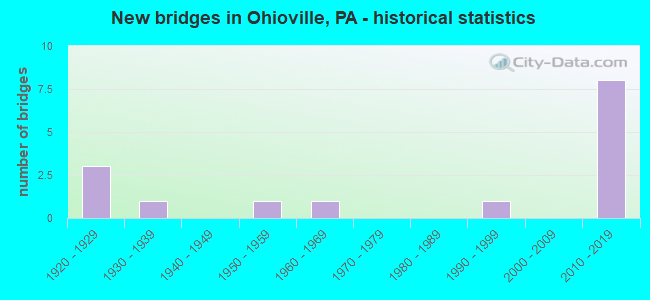
- New bridges - historical statistics
- 31920-1929
- 11930-1939
- 11950-1959
- 11960-1969
- 11990-1999
- 82010-2019

- Reconstructed bridges - Historical Statistics
- 11960-1969
- 01970-1979
- 01980-1989
- 01990-1999
- 02000-2009
- 22010-2019


- Bridge Condition - Deck
- 62.5%Very good
- 12.5%Good
- 25.0%Satisfactory

- Bridge Condition - Superstructure
- 50.0%Very good
- 12.5%Good
- 12.5%Satisfactory
- 12.5%Fair
- 12.5%Poor

- Bridge Condition - Substructure
- 37.5%Very good
- 25.0%Good
- 25.0%Satisfactory
- 12.5%Fair

- Bridge Condition - Channel
- 46.2%Very good
- 7.7%Good
- 30.8%Satisfactory
- 15.4%Fair

- Bridge Condition - Culverts
- 50.0%Very good
- 33.3%Good
- 16.7%Fair
Find on map >> Show street view
Structure Number: 3557, Location: 150' WEST OF SR 4047 (Lat: 40.647300, Lng: -80.503128), Route carried "on" structure: State highway 68, Year Built: 1925, Status: Open, Structure Length: 0.73m (2.40ft), Average Daily Traffic: 6,223 (year 2022), Truck Traffic: 7%, Average Future Daily Traffic: 4,968 (year 2032), Design Load: HS 20, Features Intersected: UPPER DRY RUN CREEK, Facility Carried by Structure: MIDLAND ROAD
Minimum Vertical Clearance: 30+ m (98+ ft), Kilometerpoint: 0.663, Lanes on structure: 2, Base Highway Network: Yes, Owner: State Highway Agency, Approaching Roadway Width: 12.2m (40.0ft), Skew: 3 degrees, Material/Design: Concrete, Design/Construction: Culvert, Number Of Spans In Main Unit: 1, Length of Maximum Span: 7.3m (24.0ft)
Condition: Channel: Satisfactory, Culverts: Fair, Operating Rating: 49.0 metric tons, Method Used To Determine Operating Rating: Field evaluation and documented engineering judgment, Inventory Rating: 32.7 metric tons, Method Used To Determine Inventory Rating: Field evaluation and documented engineering judgment, Structural Evaluation: Somewhat better than minimum adequacy, Waterway Adequacy: Superior to present desirable criteria, Approach Roadway Alignment: Equal to present desirable criteria, Length Of Structure Improvement: 0.70m (2.30ft), Designated Inspection Frequency: Every 24 months, Inspection Date: August 2020, Bridge Improvement Cost: $12,000, Roadway Improvement Cost: $35,000, Total Project Cost: $161,000
Find on map >> Show street view
Structure Number: 3558, Location: 5000' EAST OF OHIO LINE (Lat: 40.647483, Lng: -80.502264), Route carried "on" structure: State highway 68, Year Built: 1926, Status: Open, Structure Length: 0.82m (2.69ft), Average Daily Traffic: 6,223 (year 2022), Truck Traffic: 7%, Average Future Daily Traffic: 4,968 (year 2032), Design Load: HS 20, Features Intersected: LR 278-LIBERTY ST, Facility Carried by Structure: MIDLAND ROAD
Minimum Vertical Clearance: 30+ m (98+ ft), Kilometerpoint: 1.474, Lanes on structure: 2, Lanes under structure: 2, Base Highway Network: Yes, Owner: State Highway Agency, Approaching Roadway Width: 9.8m (32.2ft), Material/Design: Concrete, Design/Construction: Slab, Number Of Spans In Main Unit: 1, Length of Maximum Span: 7.3m (24.0ft), Curb-To-Curb Width: 12.8m (42.0ft), Out-to-Out Width: 13.4m (44.0ft)
Condition: Deck: Good, Superstructure: Good, Substructure: Satisfactory, Operating Rating: 77.1 metric tons, Method Used To Determine Operating Rating: Load Factor (LF), Inventory Rating: 46.3 metric tons, Method Used To Determine Inventory Rating: Load Factor (LF), Structural Evaluation: Equal to present minimum criteria, Deck Geometry: Somewhat better than minimum adequacy, Underclear: High priority of corrective action, Approach Roadway Alignment: Equal to present desirable criteria, Length Of Structure Improvement: 0.80m (2.62ft), Designated Inspection Frequency: Every 24 months, Inspection Date: August 2020, Bridge Improvement Cost: $6,000, Roadway Improvement Cost: $27,000, Total Project Cost: $78,000, Deck Structure Type: Concrete Cast-file-Place, Wearing Surface/Protective System: Wearing Surface: Monolithic Concrete
Find on map >> Show street view
Structure Number: 3608, Location: OVER BRUSH RUN @ COURT RD (Lat: 40.755483, Lng: -80.458808), Route carried "on" structure: State highway 251, Year Built: 1932, Year Reconstructed: 1971, Status: Open, Structure Length: 0.76m (2.49ft), Average Daily Traffic: 1,814 (year 2022), Truck Traffic: 4%, Average Future Daily Traffic: 1,981 (year 2032), Design Load: HS 20, Features Intersected: BRUSH RUN, Facility Carried by Structure: BLACKHAWK RD
Minimum Vertical Clearance: 30+ m (98+ ft), Kilometerpoint: 5.755, Lanes on structure: 2, Owner: State Highway Agency, Approaching Roadway Width: 7.3m (24.0ft), Material/Design: Concrete, Design/Construction: Tee Beam, Number Of Spans In Main Unit: 1, Length of Maximum Span: 7.3m (24.0ft), Curb-To-Curb Width: 11.6m (38.1ft), Out-to-Out Width: 12.5m (41.0ft)
Condition: Deck: Satisfactory, Superstructure: Fair, Substructure: Fair, Channel: Satisfactory, Operating Rating: 49.9 metric tons, Method Used To Determine Operating Rating: Load Factor (LF), Inventory Rating: 29.9 metric tons, Method Used To Determine Inventory Rating: Load Factor (LF), Structural Evaluation: Somewhat better than minimum adequacy, Deck Geometry: Equal to present minimum criteria, Waterway Adequacy: Equal to present minimum criteria, Approach Roadway Alignment: Equal to present desirable criteria, Length Of Structure Improvement: 0.80m (2.62ft), Designated Inspection Frequency: Every 24 months, Inspection Date: March 2021, Bridge Improvement Cost: $19,000, Roadway Improvement Cost: $55,000, Total Project Cost: $252,000, Deck Structure Type: Concrete Cast-file-Place, Wearing Surface/Protective System: Wearing Surface: Bituminous
Find on map >> Show street view
Structure Number: 3758, Location: 250'WEST OF TWP RD 406 (Lat: 40.707661, Lng: -80.434078), Route carried "on" structure: State highway , Year Built: 1960, Status: Posted for load, Structure Length: 1.19m (3.90ft), Average Daily Traffic: 1,076 (year 2022), Truck Traffic: 1%, Average Future Daily Traffic: 1,326 (year 2032), Design Load: HS 20, Features Intersected: SOUTH BR. BRADYS RUN, Facility Carried by Structure: LISBON RD
Minimum Vertical Clearance: 30+ m (98+ ft), Kilometerpoint: 9.196, Lanes on structure: 2, Owner: State Highway Agency, Approaching Roadway Width: 5.5m (18.0ft), Skew: 1 degrees, Material/Design: Prestressed concrete, Design/Construction: Box Beam or Girders - Multiple, Number Of Spans In Main Unit: 1, Length of Maximum Span: 11.0m (36.1ft), Curb or Sidewalk Widths: Left: 0.5m (1.6ft), Right: 0.5m (1.6ft), Curb-To-Curb Width: 8.5m (27.9ft), Out-to-Out Width: 10.2m (33.5ft)
Condition: Deck: Satisfactory, Superstructure: Poor, Substructure: Satisfactory, Channel: Fair, Operating Rating: 31.8 metric tons, Method Used To Determine Operating Rating: Load Factor (LF), Inventory Rating: 0.9 metric tons, Method Used To Determine Inventory Rating: Load Factor (LF), Structural Evaluation: High priority of corrective action, Deck Geometry: Somewhat better than minimum adequacy, Waterway Adequacy: Better than present minimum criteria, Approach Roadway Alignment: Equal to present desirable criteria, Bridge Posting: Required (Relationship of Operating Rating to Maximum Legal Load: 20.0 - 29.9% below), Length Of Structure Improvement: 1.10m (3.61ft), Designated Inspection Frequency: Every 24 months, Other Special Inspection Frequency: Every 12 months, Inspection Date: Febuary 2021, Other Special Inspection Date: Febuary 2021, Deck Structure Type: Other, Wearing Surface/Protective System: Wearing Surface: Bituminous
Find on map >> Show street view
Structure Number: 377, Location: 100' N.W. OF SR 0168 (Lat: 40.660775, Lng: -80.479033), Route carried "on" structure: State highway , Year Built: 1954, Year Reconstructed: 2017, Status: Open, Structure Length: 0.91m (2.99ft), Average Daily Traffic: 419 (year 2020), Truck Traffic: 7%, Average Future Daily Traffic: 329 (year 2032), Design Load: HL 93, Features Intersected: UPPER DRY RUN, Facility Carried by Structure: WESTWOOD RD
Minimum Vertical Clearance: 30+ m (98+ ft), Kilometerpoint: 0.008, Lanes on structure: 2, Owner: State Highway Agency, Approaching Roadway Width: 7.6m (24.9ft), Skew: 3 degrees, Material/Design: Prestressed concrete, Design/Construction: Box Beam or Girders - Single/Spread, Number Of Spans In Main Unit: 1, Length of Maximum Span: 8.5m (27.9ft), Curb-To-Curb Width: 7.8m (25.6ft), Out-to-Out Width: 8.4m (27.6ft)
Condition: Deck: Very good, Superstructure: Very good, Substructure: Good, Channel: Fair, Operating Rating: 45.0 metric tons, Method Used To Determine Operating Rating: Assigned ratings based on Load and Resistance Factor Design (LRFD) reported by rating factor (RF) using HL93 loadings, Inventory Rating: 34.7 metric tons, Method Used To Determine Inventory Rating: Assigned ratings based on Load and Resistance Factor Design (LRFD) reported by rating factor (RF) using HL93 loadings, Structural Evaluation: Better than present minimum criteria, Deck Geometry: Meets minimum limits, Waterway Adequacy: Superior to present desirable criteria, Approach Roadway Alignment: Equal to present desirable criteria, Length Of Structure Improvement: 0.90m (2.95ft), Designated Inspection Frequency: Every 24 months, Inspection Date: Febuary 2021, Bridge Improvement Cost: $4,000, Roadway Improvement Cost: $15,000, Total Project Cost: $54,000, Deck Structure Type: Concrete Cast-file-Place, Wearing Surface/Protective System: Wearing Surface: Monolithic Concrete, Deck Protection: Epoxy Coated Reinforcing
Find on map >> Show street view
Structure Number: 3909, Location: 004050 2 MI W OF FAIRVIEW (Lat: 40.697322, Lng: -80.506600), Route carried "on" structure: City street , Year Built: 1994, Year Reconstructed: 2017, Status: Open, Structure Length: 1.01m (3.31ft), Average Daily Traffic: 50 (year 2019), Truck Traffic: 1%, Average Future Daily Traffic: 50 (year 2041), Design Load: HS 25 or greater, Features Intersected: BIELERS RUN, Facility Carried by Structure: BIELERS RUN ROAD
Minimum Vertical Clearance: 30+ m (98+ ft), Kilometerpoint: 0.000, Lanes on structure: 2, Owner: County Highway Agency, Approaching Roadway Width: 6.4m (21.0ft), Skew: 3 degrees, Material/Design: Prestressed concrete, Design/Construction: Box Beam or Girders - Multiple, Number Of Spans In Main Unit: 1, Length of Maximum Span: 9.8m (32.2ft), Curb or Sidewalk Widths: Left: 0.2m (0.7ft), Right: 0.2m (0.7ft), Curb-To-Curb Width: 7.6m (24.9ft), Out-to-Out Width: 8.6m (28.2ft)
Condition: Deck: Very good, Superstructure: Satisfactory, Substructure: Good, Channel: Very good, Inventory Rating: 59.9 metric tons, Method Used To Determine Inventory Rating: Load Factor (LF), Structural Evaluation: Equal to present minimum criteria, Deck Geometry: Equal to present minimum criteria, Waterway Adequacy: Better than present minimum criteria, Approach Roadway Alignment: Equal to present desirable criteria, Length Of Structure Improvement: 1.00m (3.28ft), Designated Inspection Frequency: Every 24 months, Inspection Date: November 2019, Wearing Surface/Protective System: Wearing Surface: Monolithic Concrete, Deck Protection: Epoxy Coated Reinforcing
Find on map >> Show street view
Structure Number: 46601, Location: 1.5 Mi N of SR 4028 (Lat: 40.701944, Lng: -80.484167), Route carried "on" structure: State highway 168, Year Built: 2011, Status: Open, Structure Length: 0.64m (2.10ft), Average Daily Traffic: 587 (year 2021), Truck Traffic: 9%, Average Future Daily Traffic: 1,037 (year 2032), Design Load: HL 93, Features Intersected: Bieler Run, Facility Carried by Structure: Salem Church Road
Minimum Vertical Clearance: 30+ m (98+ ft), Kilometerpoint: 30.314, Lanes on structure: 2, Owner: State Highway Agency, Approaching Roadway Width: 9.1m (29.9ft), Skew: 1 degrees, Material/Design: Concrete, Design/Construction: Culvert, Number Of Spans In Main Unit: 1, Length of Maximum Span: 5.8m (19.0ft), Curb-To-Curb Width: 9.1m (29.9ft), Out-to-Out Width: 10.5m (34.4ft)
Condition: Channel: Satisfactory, Culverts: Very good, Operating Rating: 61.9 metric tons, Method Used To Determine Operating Rating: Assigned ratings based on Load and Resistance Factor Design (LRFD) reported by rating factor (RF) using HL93 loadings, Inventory Rating: 34.7 metric tons, Method Used To Determine Inventory Rating: Assigned ratings based on Load and Resistance Factor Design (LRFD) reported by rating factor (RF) using HL93 loadings, Structural Evaluation: Equal to present desirable criteria, Deck Geometry: Equal to present minimum criteria, Waterway Adequacy: Equal to present minimum criteria, Approach Roadway Alignment: Equal to present desirable criteria, Designated Inspection Frequency: Every 48 months, Inspection Date: March 2019, Wearing Surface/Protective System: Wearing Surface: Monolithic Concrete, Deck Protection: Other Coated Reinforcing
Find on map >> Show street view
Structure Number: 46994, Location: 400' NORTH OF SR 4034 (Lat: 40.658333, Lng: -80.500000), Route carried "on" structure: State highway , Year Built: 2012, Status: Open, Structure Length: 0.85m (2.79ft), Average Daily Traffic: 641 (year 2022), Truck Traffic: 6%, Average Future Daily Traffic: 259 (year 2039), Design Load: HS 25 or greater, Features Intersected: UPPER DRY RUN, Facility Carried by Structure: SMITH FERRY
Minimum Vertical Clearance: 30+ m (98+ ft), Kilometerpoint: 1.539, Lanes on structure: 2, Owner: State Highway Agency, Approaching Roadway Width: 8.5m (27.9ft), Material/Design: Concrete, Design/Construction: Culvert, Number Of Spans In Main Unit: 1, Length of Maximum Span: 8.5m (27.9ft), Curb or Sidewalk Widths: Left: 0.2m (0.7ft), Right: 0.2m (0.7ft), Curb-To-Curb Width: 7.3m (24.0ft), Out-to-Out Width: 7.9m (25.9ft)
Condition: Channel: Very good, Culverts: Good, Inventory Rating: 85.3 metric tons, Method Used To Determine Inventory Rating: Assigned rating based on Load Factor Design (LFD) reported in metric tons, Structural Evaluation: Better than present minimum criteria, Deck Geometry: Meets minimum limits, Waterway Adequacy: Equal to present desirable criteria, Approach Roadway Alignment: Equal to present desirable criteria, Designated Inspection Frequency: Every 24 months, Inspection Date: Febuary 2021
Find on map >> Show street view
Structure Number: 53556, Location: 150' SW Watts Mill Rd (Lat: 40.761514, Lng: -80.492656), Route carried "on" structure: State highway 251, Year Built: 2016, Status: Open, Structure Length: 1.46m (4.79ft), Average Daily Traffic: 1,045 (year 2022), Truck Traffic: 13%, Average Future Daily Traffic: 1,678 (year 2032), Design Load: HL 93, Features Intersected: Brush Run, Facility Carried by Structure: Blackhawk Road
Minimum Vertical Clearance: 30+ m (98+ ft), Kilometerpoint: 2.290, Lanes on structure: 2, Owner: State Highway Agency, Approaching Roadway Width: 7.6m (24.9ft), Skew: 3 degrees, Material/Design: Prestressed concrete, Design/Construction: Box Beam or Girders - Multiple, Number Of Spans In Main Unit: 1, Length of Maximum Span: 14.3m (46.9ft), Curb or Sidewalk Widths: Left: 0.1m (0.3ft), Right: 0.1m (0.3ft), Curb-To-Curb Width: 11.6m (38.1ft), Out-to-Out Width: 12.6m (41.3ft)
Condition: Deck: Very good, Superstructure: Very good, Substructure: Very good, Channel: Very good, Operating Rating: 46.0 metric tons, Method Used To Determine Operating Rating: Assigned ratings based on Load and Resistance Factor Design (LRFD) reported by rating factor (RF) using HL93 loadings, Inventory Rating: 35.6 metric tons, Method Used To Determine Inventory Rating: Assigned ratings based on Load and Resistance Factor Design (LRFD) reported by rating factor (RF) using HL93 loadings, Structural Evaluation: Equal to present desirable criteria, Deck Geometry: Equal to present minimum criteria, Waterway Adequacy: Equal to present desirable criteria, Approach Roadway Alignment: Equal to present desirable criteria, Designated Inspection Frequency: Every 48 months, Inspection Date: March 2019, Deck Structure Type: Concrete Cast-file-Place, Wearing Surface/Protective System: Wearing Surface: Monolithic Concrete, Deck Protection: Epoxy Coated Reinforcing
Find on map >> Show street view
Structure Number: 53578, Location: 1/2 MI. WEST OF SR 4021 (Lat: 40.746878, Lng: -80.385653), Route carried "on" structure: State highway , Year Built: 2016, Status: Open, Structure Length: 0.88m (2.89ft), Average Daily Traffic: 695 (year 2020), Truck Traffic: 5%, Average Future Daily Traffic: 1,497 (year 2037), Design Load: HL 93, Features Intersected: N. BR. BRADYS RUN, Facility Carried by Structure: PARK RD
Minimum Vertical Clearance: 30+ m (98+ ft), Kilometerpoint: 3.327, Lanes on structure: 2, Owner: State Highway Agency, Maintenance Responsibility: Private, Approaching Roadway Width: 9.1m (29.9ft), Skew: 4 degrees, Material/Design: Concrete, Design/Construction: Culvert, Number Of Spans In Main Unit: 1, Length of Maximum Span: 8.8m (28.9ft), Curb-To-Curb Width: 9.2m (30.2ft), Out-to-Out Width: 10.5m (34.4ft)
Condition: Channel: Very good, Culverts: Good, Operating Rating: 56.1 metric tons, Method Used To Determine Operating Rating: Assigned ratings based on Load and Resistance Factor Design (LRFD) reported by rating factor (RF) using HL93 loadings, Inventory Rating: 35.3 metric tons, Method Used To Determine Inventory Rating: Assigned ratings based on Load and Resistance Factor Design (LRFD) reported by rating factor (RF) using HL93 loadings, Structural Evaluation: Better than present minimum criteria, Deck Geometry: Equal to present minimum criteria, Waterway Adequacy: Superior to present desirable criteria, Approach Roadway Alignment: Equal to present desirable criteria, Designated Inspection Frequency: Every 24 months, Inspection Date: March 2020, Wearing Surface/Protective System: Membrane: Preformed Fabric
Find on map >> Show street view
Structure Number: 54041, Location: 100'N.OF SR 4034 (Lat: 40.660683, Lng: -80.476856), Route carried "on" structure: State highway 168, Year Built: 2018, Status: Open, Structure Length: 1.01m (3.31ft), Average Daily Traffic: 1,696 (year 2022), Truck Traffic: 5%, Average Future Daily Traffic: 3,557 (year 2037), Design Load: HL 93, Features Intersected: UPPER DRY RUN, Facility Carried by Structure: FAIRVIEW RD
Minimum Vertical Clearance: 30+ m (98+ ft), Kilometerpoint: 24.093, Lanes on structure: 2, Owner: State Highway Agency, Maintenance Responsibility: Private, Approaching Roadway Width: 6.7m (22.0ft), Skew: 4 degrees, Material/Design: Concrete, Design/Construction: Culvert, Number Of Spans In Main Unit: 1, Length of Maximum Span: 10.1m (33.1ft), Curb-To-Curb Width: 9.8m (32.2ft), Out-to-Out Width: 10.8m (35.4ft)
Condition: Channel: Very good, Culverts: Very good, Operating Rating: 52.8 metric tons, Method Used To Determine Operating Rating: Assigned ratings based on Load and Resistance Factor Design (LRFD) reported by rating factor (RF) using HL93 loadings, Inventory Rating: 33.4 metric tons, Method Used To Determine Inventory Rating: Assigned ratings based on Load and Resistance Factor Design (LRFD) reported by rating factor (RF) using HL93 loadings, Structural Evaluation: Equal to present desirable criteria, Deck Geometry: Somewhat better than minimum adequacy, Waterway Adequacy: Superior to present desirable criteria, Approach Roadway Alignment: Equal to present desirable criteria, Designated Inspection Frequency: Every 24 months, Inspection Date: March 2020, Wearing Surface/Protective System: Membrane: Preformed Fabric
Find on map >> Show street view
Structure Number: 54071, Location: 500' WEST OF SR 0068 (Lat: 40.660786, Lng: -80.479053), Route carried "on" structure: State highway , Year Built: 2017, Status: Open, Structure Length: 0.73m (2.40ft), Average Daily Traffic: 283 (year 2021), Truck Traffic: 10%, Average Future Daily Traffic: 441 (year 2037), Design Load: HL 93, Features Intersected: UPPER DRY RUN, Facility Carried by Structure: WESTWOOD DR
Minimum Vertical Clearance: 30+ m (98+ ft), Kilometerpoint: 0.000, Lanes on structure: 2, Owner: State Highway Agency, Maintenance Responsibility: Private, Approaching Roadway Width: 5.5m (18.0ft), Skew: 3 degrees, Material/Design: Concrete, Design/Construction: Culvert, Number Of Spans In Main Unit: 1, Length of Maximum Span: 6.7m (22.0ft), Curb-To-Curb Width: 6.7m (22.0ft), Out-to-Out Width: 10.1m (33.1ft)
Condition: Channel: Good, Culverts: Very good, Operating Rating: 53.5 metric tons, Method Used To Determine Operating Rating: Assigned ratings based on Load and Resistance Factor Design (LRFD) reported by rating factor (RF) using HL93 loadings, Inventory Rating: 33.7 metric tons, Method Used To Determine Inventory Rating: Assigned ratings based on Load and Resistance Factor Design (LRFD) reported by rating factor (RF) using HL93 loadings, Structural Evaluation: Equal to present desirable criteria, Deck Geometry: Meets minimum limits, Waterway Adequacy: Equal to present desirable criteria, Approach Roadway Alignment: Equal to present desirable criteria, Designated Inspection Frequency: Every 24 months, Inspection Date: March 2021, Wearing Surface/Protective System: Wearing Surface: Bituminous, Membrane: Preformed Fabric, Deck Protection: Epoxy Coated Reinforcing
Find on map >> Show street view
Structure Number: 54162, Location: 0.3 Mi. NE of SR 0251 (Lat: 40.760708, Lng: -80.468053), Route carried "on" structure: State highway 168, Year Built: 2017, Status: Open, Structure Length: 1.37m (4.49ft), Average Daily Traffic: 851 (year 2021), Truck Traffic: 9%, Average Future Daily Traffic: 1,249 (year 2032), Design Load: HL 93, Features Intersected: Brush Run, Facility Carried by Structure: Salem Church Road
Minimum Vertical Clearance: 30+ m (98+ ft), Kilometerpoint: 37.440, Lanes on structure: 2, Owner: State Highway Agency, Approaching Roadway Width: 9.1m (29.9ft), Material/Design: Prestressed concrete, Design/Construction: Box Beam or Girders - Multiple, Number Of Spans In Main Unit: 1, Length of Maximum Span: 13.4m (44.0ft), Curb or Sidewalk Widths: Left: 0.2m (0.7ft), Right: 0.2m (0.7ft), Curb-To-Curb Width: 9.1m (29.9ft), Out-to-Out Width: 10.2m (33.5ft)
Condition: Deck: Very good, Superstructure: Very good, Substructure: Very good, Channel: Satisfactory, Operating Rating: 45.0 metric tons, Method Used To Determine Operating Rating: Assigned ratings based on Load and Resistance Factor Design (LRFD) reported by rating factor (RF) using HL93 loadings, Inventory Rating: 34.7 metric tons, Method Used To Determine Inventory Rating: Assigned ratings based on Load and Resistance Factor Design (LRFD) reported by rating factor (RF) using HL93 loadings, Structural Evaluation: Equal to present desirable criteria, Deck Geometry: Equal to present minimum criteria, Waterway Adequacy: Equal to present minimum criteria, Approach Roadway Alignment: Equal to present desirable criteria, Designated Inspection Frequency: Every 24 months, Inspection Date: March 2021, Deck Structure Type: Concrete Cast-file-Place, Wearing Surface/Protective System: Wearing Surface: Monolithic Concrete, Deck Protection: Epoxy Coated Reinforcing
Find on map >> Show street view
Structure Number: 54254, Location: 100' NW Twp Rd 301 (Lat: 40.722975, Lng: -80.408211), Route carried "on" structure: State highway , Year Built: 2017, Status: Open, Structure Length: 1.52m (4.99ft), Average Daily Traffic: 82 (year 2021), Truck Traffic: 4%, Average Future Daily Traffic: 100 (year 2039), Design Load: HL 93, Features Intersected: S. Branch Brady Run, Facility Carried by Structure: Brady Run Road
Minimum Vertical Clearance: 30+ m (98+ ft), Kilometerpoint: 3.573, Lanes on structure: 2, Owner: State Highway Agency, Approaching Roadway Width: 6.7m (22.0ft), Skew: 3 degrees, Material/Design: Prestressed concrete, Design/Construction: Box Beam or Girders - Multiple, Number Of Spans In Main Unit: 1, Length of Maximum Span: 14.6m (47.9ft), Curb or Sidewalk Widths: Left: 0.2m (0.7ft), Right: 0.2m (0.7ft), Curb-To-Curb Width: 6.7m (22.0ft), Out-to-Out Width: 7.7m (25.3ft)
Condition: Deck: Very good, Superstructure: Very good, Substructure: Very good, Channel: Very good, Operating Rating: 45.0 metric tons, Method Used To Determine Operating Rating: Assigned ratings based on Load and Resistance Factor Design (LRFD) reported by rating factor (RF) using HL93 loadings, Inventory Rating: 34.7 metric tons, Method Used To Determine Inventory Rating: Assigned ratings based on Load and Resistance Factor Design (LRFD) reported by rating factor (RF) using HL93 loadings, Structural Evaluation: Equal to present desirable criteria, Deck Geometry: Somewhat better than minimum adequacy, Waterway Adequacy: Better than present minimum criteria, Approach Roadway Alignment: Equal to present minimum criteria, Designated Inspection Frequency: Every 24 months, Inspection Date: Febuary 2021, Deck Structure Type: Concrete Cast-file-Place, Wearing Surface/Protective System: Wearing Surface: Monolithic Concrete, Deck Protection: Epoxy Coated Reinforcing
Find on map >> Show street view
Structure Number: 3558, Location: 5000' EAST OF OHIO LINE (Lat: 40.647483, Lng: -80.502264), Route carried "under" structure: State highway , Year Built: 1926, Structure Length: 0. m, Average Daily Traffic: 870 (year 2020), Truck Traffic: 1%, Features Intersected: LR 278-LIBERTY ST, Facility Carried by Structure: MIDLAND ROAD
Minimum Vertical Clearance: 3.43m (11.25ft), Kilometerpoint: 0.000, Lanes on structure: 2, Lanes under structure: 2, Material/Design: Concrete, Design/Construction: Slab, Length of Maximum Span: 7.3m (24.0ft)