Bridge Statistics for Okolona, Kentucky (KY)
Condition, Traffic, Stress, Structural Evaluation, Project Costs
- National Bridge Inventory (NBI) Statistics
- 16Number of bridges
- 128ft / 39.3mTotal length
- $288,000Total costs
- 512,670Total average daily traffic
- 58,643Total average daily truck traffic
- 527,216Total future (year 2029) average daily traffic
- National Bridge Inventory (NBI) Registered Bridges for Okolona
- No street view available for this location
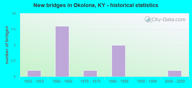
- New bridges - historical statistics
- 11950-1959
- 81960-1969
- 11970-1979
- 51980-1989
- 12000-2009


- Bridge Condition - Deck
- 45.5%Satisfactory
- 45.5%Fair
- 9.1%Poor

- Bridge Condition - Superstructure
- 9.1%Good
- 27.3%Satisfactory
- 45.5%Fair
- 18.2%Poor

- Bridge Condition - Substructure
- 36.4%Good
- 27.3%Satisfactory
- 36.4%Fair

- Bridge Condition - Channel
- 6.3%Very good
- 50.0%Good
- 31.3%Satisfactory
- 12.5%Fair

- Bridge Condition - Culverts
- 80.0%Satisfactory
- 20.0%Fair
Find on map >> Show street view
Structure Number: 56B00030N, Location: 0.35 MI S OF KY 1747 (Lat: 38.152500, Lng: -85.694444), Route carried "on" structure: State highway 61, Year Built: 1965, Status: Open, Structure Length: 1.96m (6.43ft), Average Daily Traffic: 27,081 (year 2018), Truck Traffic: 6%, Average Future Daily Traffic: 25,185 (year 2038), Design Load: H 20, Features Intersected: BLUE SPRING DITCH
Minimum Vertical Clearance: 30+ m (98+ ft), Kilometerpoint: 8.052, Lanes on structure: 4, Owner: State Highway Agency, Approaching Roadway Width: 21.9m (71.9ft), Material/Design: Steel, Design/Construction: Stringer/Multi-beam, Number Of Spans In Main Unit: 1, Length of Maximum Span: 18.3m (60.0ft), Curb-To-Curb Width: 21.9m (71.9ft), Out-to-Out Width: 23.1m (75.8ft)
Condition: Deck: Fair, Superstructure: Fair, Substructure: Satisfactory, Channel: Good, Operating Rating: 85.1 metric tons, Method Used To Determine Operating Rating: Load Factor (LF), Inventory Rating: 51.1 metric tons, Method Used To Determine Inventory Rating: Load Factor (LF), Structural Evaluation: Somewhat better than minimum adequacy, Deck Geometry: Superior to present desirable criteria, Waterway Adequacy: Equal to present minimum criteria, Approach Roadway Alignment: Equal to present desirable criteria, Designated Inspection Frequency: Every 24 months, Inspection Date: June 2020, Deck Structure Type: Concrete Cast-file-Place, Wearing Surface/Protective System: Wearing Surface: Monolithic Concrete
Find on map >> Show street view
Structure Number: 56B00031N, Location: 0.5 MI S OF KY 1747 (Lat: 38.150000, Lng: -85.693056), Route carried "on" structure: State highway 61, Year Built: 1965, Status: Open, Structure Length: 2.59m (8.50ft), Average Daily Traffic: 27,081 (year 2018), Truck Traffic: 6%, Average Future Daily Traffic: 25,185 (year 2038), Design Load: HS 20, Features Intersected: NORTHERN DITCH
Minimum Vertical Clearance: 30+ m (98+ ft), Kilometerpoint: 7.763, Lanes on structure: 4, Owner: State Highway Agency, Approaching Roadway Width: 21.9m (71.9ft), Skew: 3 degrees, Material/Design: Steel, Design/Construction: Stringer/Multi-beam, Number Of Spans In Main Unit: 1, Length of Maximum Span: 24.4m (80.1ft), Curb-To-Curb Width: 21.9m (71.9ft), Out-to-Out Width: 23.1m (75.8ft)
Condition: Deck: Fair, Superstructure: Fair, Substructure: Satisfactory, Channel: Good, Operating Rating: 81.9 metric tons, Method Used To Determine Operating Rating: Load Factor (LF), Inventory Rating: 49.2 metric tons, Method Used To Determine Inventory Rating: Load Factor (LF), Structural Evaluation: Somewhat better than minimum adequacy, Deck Geometry: Superior to present desirable criteria, Waterway Adequacy: Equal to present minimum criteria, Approach Roadway Alignment: Equal to present desirable criteria, Designated Inspection Frequency: Every 24 months, Inspection Date: June 2020, Deck Structure Type: Concrete Cast-file-Place, Wearing Surface/Protective System: Wearing Surface: Monolithic Concrete
Find on map >> Show street view
Structure Number: 56B00032N, Location: 0.8 MI S OF KY 1747 (Lat: 38.146667, Lng: -85.691389), Route carried "on" structure: State highway 61, Year Built: 1965, Status: Open, Structure Length: 1.98m (6.50ft), Average Daily Traffic: 27,081 (year 2018), Truck Traffic: 6%, Average Future Daily Traffic: 25,185 (year 2038), Design Load: H 20, Features Intersected: N FK SOUTHERN DITCH
Minimum Vertical Clearance: 30+ m (98+ ft), Kilometerpoint: 7.351, Lanes on structure: 4, Owner: State Highway Agency, Approaching Roadway Width: 21.9m (71.9ft), Skew: 3 degrees, Material/Design: Steel, Design/Construction: Stringer/Multi-beam, Number Of Spans In Main Unit: 1, Length of Maximum Span: 18.3m (60.0ft), Curb or Sidewalk Widths: Left: 0.3m (1.0ft), Right: 0.3m (1.0ft), Curb-To-Curb Width: 21.9m (71.9ft), Out-to-Out Width: 23.1m (75.8ft)
Condition: Deck: Fair, Superstructure: Fair, Substructure: Satisfactory, Channel: Satisfactory, Operating Rating: 86.3 metric tons, Method Used To Determine Operating Rating: Load Factor (LF), Inventory Rating: 51.7 metric tons, Method Used To Determine Inventory Rating: Load Factor (LF), Structural Evaluation: Somewhat better than minimum adequacy, Deck Geometry: Superior to present desirable criteria, Waterway Adequacy: Equal to present minimum criteria, Approach Roadway Alignment: Equal to present desirable criteria, Designated Inspection Frequency: Every 24 months, Inspection Date: June 2020, Deck Structure Type: Concrete Cast-file-Place, Wearing Surface/Protective System: Wearing Surface: Monolithic Concrete
Find on map >> Show street view
Structure Number: 56B00078N, Location: 0.5 MI S OF KY 61 (Lat: 38.128611, Lng: -85.689444), Route carried "on" structure: State highway 1450, Year Built: 1950, Status: Posted for load, Structure Length: 0.85m (2.79ft), Average Daily Traffic: 10,811 (year 2018), Truck Traffic: 10%, Average Future Daily Traffic: 10,054 (year 2038), Design Load: H 15, Features Intersected: FISHPOOL CREEK
Minimum Vertical Clearance: 30+ m (98+ ft), Kilometerpoint: 4.868, Lanes on structure: 2, Owner: State Highway Agency, Approaching Roadway Width: 6.4m (21.0ft), Skew: 1 degrees, Material/Design: Concrete, Design/Construction: Tee Beam, Number Of Spans In Main Unit: 1, Length of Maximum Span: 7.5m (24.6ft), Curb-To-Curb Width: 7.1m (23.3ft), Out-to-Out Width: 7.8m (25.6ft)
Condition: Deck: Poor, Superstructure: Poor, Substructure: Fair, Channel: Good, Operating Rating: 16.4 metric tons, Method Used To Determine Operating Rating: Field evaluation and documented engineering judgment, Inventory Rating: 16.3 metric tons, Method Used To Determine Inventory Rating: Field evaluation and documented engineering judgment, Structural Evaluation: Meets minimum limits, Deck Geometry: High priority of replacement, Waterway Adequacy: Equal to present desirable criteria, Approach Roadway Alignment: Equal to present desirable criteria, Bridge Posting: Required (Relationship of Operating Rating to Maximum Legal Load: > 39.9% below), Length Of Structure Improvement: 0.08m (0.26ft), Designated Inspection Frequency: Every 12 months, Inspection Date: June 2021, Bridge Improvement Cost: $108,000, Roadway Improvement Cost: $20,000, Total Project Cost: $127,000, Deck Structure Type: Concrete Cast-file-Place, Wearing Surface/Protective System: Wearing Surface: Bituminous
Find on map >> Show street view
Structure Number: 56B00331N, Location: 0.75 MI N OF KY 1065 (Lat: 38.148889, Lng: -85.660000), Route carried "on" structure: State highway 2052, Year Built: 1983, Status: Open, Structure Length: 2.32m (7.61ft), Average Daily Traffic: 26,216 (year 2015), Average Future Daily Traffic: 24,380 (year 2035), Design Load: HS 20, Features Intersected: FERN CREEK
Minimum Vertical Clearance: 30+ m (98+ ft), Kilometerpoint: 1.151, Lanes on structure: 4, Owner: State Highway Agency, Approaching Roadway Width: 20.1m (65.9ft), Skew: 1 degrees, Material/Design: Prestressed concrete, Design/Construction: Box Beam or Girders - Multiple, Number Of Spans In Main Unit: 3, Length of Maximum Span: 8.6m (28.2ft), Curb or Sidewalk Widths: Left: 1.5m (4.9ft), Right: 1.5m (4.9ft), Curb-To-Curb Width: 20.1m (65.9ft), Out-to-Out Width: 23.8m (78.1ft)
Condition: Deck: Satisfactory, Superstructure: Fair, Substructure: Fair, Channel: Good, Operating Rating: 75.7 metric tons, Method Used To Determine Operating Rating: Load Factor (LF), Inventory Rating: 45.4 metric tons, Method Used To Determine Inventory Rating: Load Factor (LF), Structural Evaluation: Somewhat better than minimum adequacy, Deck Geometry: Better than present minimum criteria, Waterway Adequacy: Equal to present minimum criteria, Approach Roadway Alignment: Equal to present desirable criteria, Designated Inspection Frequency: Every 24 months, Inspection Date: August 2021, Deck Structure Type: Concrete Precast Panels, Wearing Surface/Protective System: Wearing Surface: Bituminous, Membrane: Preformed Fabric, Deck Protection: Epoxy Coated Reinforcing
Find on map >> Show street view
Structure Number: 56B00386N, Location: 3.0 MI S OF I-264 (Lat: 38.151944, Lng: -85.714722), Route carried "on" structure: Interstate 65, Year Built: 1988, Status: Open, Structure Length: 13.29m (43.60ft), Average Daily Traffic: 122,546 (year 2020), Truck Traffic: 15%, Average Future Daily Traffic: 131,124 (year 2040), Design Load: HS 20+Mod, Features Intersected: CSX RR, NORTHERN DITCH
Minimum Vertical Clearance: 30+ m (98+ ft), Kilometerpoint: 205.718, Lanes on structure: 8, Base Highway Network: Yes, Owner: State Highway Agency, Approaching Roadway Width: 83.5m (274.0ft), Skew: 33 degrees, Material/Design: Prestressed concrete continuous, Design/Construction: Stringer/Multi-beam, Number Of Spans In Main Unit: 4, Length of Maximum Span: 36.5m (119.8ft), Curb-To-Curb Width: 83.5m (274.0ft), Out-to-Out Width: 86.7m (284.4ft)
Condition: Deck: Fair, Superstructure: Satisfactory, Substructure: Fair, Channel: Very good, Operating Rating: 64.8 metric tons, Method Used To Determine Operating Rating: Load Factor (LF), Inventory Rating: 38.9 metric tons, Method Used To Determine Inventory Rating: Load Factor (LF), Structural Evaluation: Somewhat better than minimum adequacy, Deck Geometry: Superior to present desirable criteria, Underclear: Better than present minimum criteria, Waterway Adequacy: Equal to present desirable criteria, Approach Roadway Alignment: Equal to present desirable criteria, Designated Inspection Frequency: Every 24 months, Inspection Date: October 2020, Deck Structure Type: Concrete Cast-file-Place, Wearing Surface/Protective System: Wearing Surface: Monolithic Concrete, Deck Protection: Epoxy Coated Reinforcing
Find on map >> Show street view
Structure Number: 56B00387N, Location: 0.2 MI S OF KY 1747 NTRCH (Lat: 38.155000, Lng: -85.716667), Route carried "on" structure: Interstate 65, Year Built: 1988, Status: Open, Structure Length: 2.12m (6.96ft), Average Daily Traffic: 122,546 (year 2020), Truck Traffic: 15%, Average Future Daily Traffic: 131,124 (year 2040), Features Intersected: GREASY DITCH
Minimum Vertical Clearance: 30+ m (98+ ft), Kilometerpoint: 206.147, Lanes on structure: 10, Base Highway Network: Yes, Owner: State Highway Agency, Approaching Roadway Width: 93.0m (305.1ft), Skew: 34 degrees, Material/Design: Concrete, Design/Construction: Culvert, Number Of Spans In Main Unit: 4, Length of Maximum Span: 5.0m (16.4ft)
Condition: Channel: Satisfactory, Culverts: Fair, Operating Rating: 54.4 metric tons, Method Used To Determine Operating Rating: Field evaluation and documented engineering judgment, Inventory Rating: 39.9 metric tons, Method Used To Determine Inventory Rating: Field evaluation and documented engineering judgment, Structural Evaluation: Somewhat better than minimum adequacy, Waterway Adequacy: Equal to present desirable criteria, Approach Roadway Alignment: Equal to present desirable criteria, Designated Inspection Frequency: Every 24 months, Inspection Date: October 2020
Find on map >> Show street view
Structure Number: 56B00430N, Location: 145 FT S OF KY 1747 (Lat: 38.156667, Lng: -85.714444), Route carried "on" structure: State highway 6319, Year Built: 1984, Status: Open, Structure Length: 1.73m (5.68ft), Average Daily Traffic: 434 (year 2015), Average Future Daily Traffic: 407 (year 2035), Features Intersected: GREASY DITCH
Minimum Vertical Clearance: 30+ m (98+ ft), Kilometerpoint: 0.066, Lanes on structure: 2, Owner: State Highway Agency, Approaching Roadway Width: 9.1m (29.9ft), Skew: 2 degrees, Material/Design: Concrete, Design/Construction: Culvert, Number Of Spans In Main Unit: 4, Length of Maximum Span: 4.2m (13.8ft)
Condition: Channel: Satisfactory, Culverts: Satisfactory, Operating Rating: 54.4 metric tons, Method Used To Determine Operating Rating: Field evaluation and documented engineering judgment, Inventory Rating: 39.9 metric tons, Method Used To Determine Inventory Rating: Field evaluation and documented engineering judgment, Structural Evaluation: Equal to present minimum criteria, Waterway Adequacy: Equal to present desirable criteria, Approach Roadway Alignment: Equal to present desirable criteria, Designated Inspection Frequency: Every 24 months, Inspection Date: June 2020
Find on map >> Show street view
Structure Number: 56B00486N, Location: 0.15 MI S OF KY 1065 (Lat: 38.134722, Lng: -85.703056), Route carried "on" structure: Ramp Interstate 65, Year Built: 1982, Status: Open, Structure Length: 2.16m (7.09ft), Average Daily Traffic: 113,777 (year 2020), Truck Traffic: 14%, Average Future Daily Traffic: 121,741 (year 2040), Features Intersected: SOUTHERN DITCH
Minimum Vertical Clearance: 30+ m (98+ ft), Kilometerpoint: 203.661, Lanes on structure: 1, Owner: State Highway Agency, Approaching Roadway Width: 7.6m (24.9ft), Skew: 1 degrees, Material/Design: Concrete, Design/Construction: Culvert, Number Of Spans In Main Unit: 4, Length of Maximum Span: 5.2m (17.1ft)
Condition: Channel: Satisfactory, Culverts: Satisfactory, Operating Rating: 54.4 metric tons, Method Used To Determine Operating Rating: Field evaluation and documented engineering judgment, Inventory Rating: 39.9 metric tons, Method Used To Determine Inventory Rating: Field evaluation and documented engineering judgment, Structural Evaluation: Equal to present minimum criteria, Waterway Adequacy: Equal to present desirable criteria, Approach Roadway Alignment: Equal to present desirable criteria, Designated Inspection Frequency: Every 24 months, Inspection Date: October 2020
Find on map >> Show street view
Structure Number: 56C00014N, Location: 200 FT N OF ENDEAVOR WAY (Lat: 38.129722, Lng: -85.694444), Route carried "on" structure: City street 1155, Year Built: 1975, Status: Open, Structure Length: 2.90m (9.51ft), Average Daily Traffic: 4,480 (year 2009), Average Future Daily Traffic: 4,211 (year 2029), Features Intersected: FISHPOOL CREEK, Facility Carried by Structure: BOST LN
Minimum Vertical Clearance: 30+ m (98+ ft), Kilometerpoint: 0.835, Lanes on structure: 2, Owner: County Highway Agency, Approaching Roadway Width: 7.9m (25.9ft), Material/Design: Prestressed concrete, Design/Construction: Box Beam or Girders - Multiple, Number Of Spans In Main Unit: 1, Length of Maximum Span: 27.7m (90.9ft), Curb or Sidewalk Widths: Left: 1.1m (3.6ft), Right: 1.1m (3.6ft), Curb-To-Curb Width: 8.7m (28.5ft), Out-to-Out Width: 11.1m (36.4ft)
Condition: Deck: Satisfactory, Superstructure: Satisfactory, Substructure: Good, Channel: Fair, Operating Rating: 59.5 metric tons, Method Used To Determine Operating Rating: Load Factor (LF), Inventory Rating: 35.7 metric tons, Method Used To Determine Inventory Rating: Load Factor (LF), Structural Evaluation: Equal to present minimum criteria, Deck Geometry: Meets minimum limits, Waterway Adequacy: Equal to present desirable criteria, Approach Roadway Alignment: Equal to present desirable criteria, Designated Inspection Frequency: Every 24 months, Inspection Date: January 2020, Deck Structure Type: Concrete Precast Panels, Wearing Surface/Protective System: Wearing Surface: Bituminous
Find on map >> Show street view
Structure Number: 56C00017N, Location: 0.15 MI S OF KY 1065 (Lat: 38.133889, Lng: -85.697222), Route carried "on" structure: City street 1473, Year Built: 1965, Status: Posted for load, Structure Length: 1.16m (3.81ft), Average Daily Traffic: 8,087 (year 2009), Average Future Daily Traffic: 7,601 (year 2029), Features Intersected: SOUTHERN DITCH, Facility Carried by Structure: BRIARCLIFF RD
Minimum Vertical Clearance: 30+ m (98+ ft), Kilometerpoint: 0.257, Lanes on structure: 2, Owner: County Highway Agency, Approaching Roadway Width: 7.0m (23.0ft), Skew: 1 degrees, Material/Design: Prestressed concrete, Design/Construction: Box Beam or Girders - Multiple, Number Of Spans In Main Unit: 1, Length of Maximum Span: 10.4m (34.1ft), Curb-To-Curb Width: 7.7m (25.3ft), Out-to-Out Width: 10.1m (33.1ft)
Condition: Deck: Satisfactory, Superstructure: Satisfactory, Substructure: Good, Channel: Satisfactory, Operating Rating: 73.1 metric tons, Method Used To Determine Operating Rating: Load Factor (LF), Inventory Rating: 43.8 metric tons, Method Used To Determine Inventory Rating: Load Factor (LF), Structural Evaluation: Equal to present minimum criteria, Deck Geometry: High priority of replacement, Waterway Adequacy: Equal to present desirable criteria, Approach Roadway Alignment: Equal to present desirable criteria, Length Of Structure Improvement: 0.12m (0.39ft), Designated Inspection Frequency: Every 24 months, Inspection Date: January 2020, Bridge Improvement Cost: $162,000, Total Project Cost: $161,000, Deck Structure Type: Concrete Precast Panels, Wearing Surface/Protective System: Wearing Surface: Bituminous
Find on map >> Show street view
Structure Number: 56C00121N, Location: 100 FT N OF KY 1450 (Lat: 38.133333, Lng: -85.685278), Route carried "on" structure: City street 2646, Year Built: 1965, Status: Posted for load, Structure Length: 1.14m (3.74ft), Average Daily Traffic: 3,323 (year 2009), Average Future Daily Traffic: 3,123 (year 2029), Design Load: H 20, Features Intersected: SOUTHERN DITCH, Facility Carried by Structure: WILLIAM G PENNY LN
Minimum Vertical Clearance: 30+ m (98+ ft), Kilometerpoint: 0.029, Lanes on structure: 2, Owner: County Highway Agency, Approaching Roadway Width: 6.8m (22.3ft), Material/Design: Prestressed concrete, Design/Construction: Box Beam or Girders - Multiple, Number Of Spans In Main Unit: 1, Length of Maximum Span: 10.4m (34.1ft), Curb-To-Curb Width: 6.8m (22.3ft), Out-to-Out Width: 8.3m (27.2ft)
Condition: Deck: Fair, Superstructure: Fair, Substructure: Fair, Channel: Fair, Operating Rating: 48.6 metric tons, Method Used To Determine Operating Rating: Load Factor (LF), Inventory Rating: 29.2 metric tons, Method Used To Determine Inventory Rating: Load Factor (LF), Structural Evaluation: Somewhat better than minimum adequacy, Deck Geometry: High priority of replacement, Waterway Adequacy: Equal to present desirable criteria, Approach Roadway Alignment: Equal to present desirable criteria, Bridge Posting: Required (Relationship of Operating Rating to Maximum Legal Load: 10.0 - 19.9% below), Designated Inspection Frequency: Every 24 months, Inspection Date: January 2020, Deck Structure Type: Concrete Precast Panels, Wearing Surface/Protective System: Wearing Surface: Bituminous
Find on map >> Show street view
Structure Number: 56C00235N, Location: 0.1 MI E OF KY 61 (Lat: 38.144722, Lng: -85.688611), Route carried "on" structure: County highway 1023, Year Built: 1960, Status: Open, Structure Length: 0.79m (2.59ft), Average Daily Traffic: 4,325 (year 2019), Average Future Daily Traffic: 4,022 (year 2039), Features Intersected: TRIB TO WET WOODS CREEK, Facility Carried by Structure: MCCAWLEY RD
Minimum Vertical Clearance: 30+ m (98+ ft), Kilometerpoint: 0.154, Lanes on structure: 2, Owner: County Highway Agency, Approaching Roadway Width: 8.1m (26.6ft), Skew: 3 degrees, Material/Design: Concrete, Design/Construction: Culvert, Number Of Spans In Main Unit: 2, Length of Maximum Span: 3.8m (12.5ft), Curb-To-Curb Width: 8.1m (26.6ft), Out-to-Out Width: 8.7m (28.5ft)
Condition: Channel: Good, Culverts: Satisfactory, Operating Rating: 54.4 metric tons, Method Used To Determine Operating Rating: Field evaluation and documented engineering judgment, Inventory Rating: 39.9 metric tons, Method Used To Determine Inventory Rating: Field evaluation and documented engineering judgment, Structural Evaluation: Equal to present minimum criteria, Deck Geometry: High priority of corrective action, Waterway Adequacy: Equal to present desirable criteria, Approach Roadway Alignment: Equal to present desirable criteria, Designated Inspection Frequency: Every 24 months, Inspection Date: January 2020
Find on map >> Show street view
Structure Number: 56C00236N, Location: 350 FT E OF KY 61 (Lat: 38.146389, Lng: -85.690000), Route carried "on" structure: Other road 1183, Year Built: 1960, Status: Open, Structure Length: 0.79m (2.59ft), Average Daily Traffic: 1,494 (year 2009), Average Future Daily Traffic: 1,404 (year 2029), Features Intersected: TRIB TO WET WOODS CREEK, Facility Carried by Structure: CANAL ST
Minimum Vertical Clearance: 30+ m (98+ ft), Kilometerpoint: 0.106, Lanes on structure: 2, Owner: County Highway Agency, Approaching Roadway Width: 6.4m (21.0ft), Skew: 3 degrees, Material/Design: Concrete, Design/Construction: Culvert, Number Of Spans In Main Unit: 2, Length of Maximum Span: 3.8m (12.5ft), Curb-To-Curb Width: 8.1m (26.6ft), Out-to-Out Width: 8.8m (28.9ft)
Condition: Channel: Good, Culverts: Satisfactory, Operating Rating: 54.4 metric tons, Method Used To Determine Operating Rating: Field evaluation and documented engineering judgment, Inventory Rating: 39.9 metric tons, Method Used To Determine Inventory Rating: Field evaluation and documented engineering judgment, Structural Evaluation: Equal to present minimum criteria, Deck Geometry: Meets minimum limits, Waterway Adequacy: Equal to present desirable criteria, Approach Roadway Alignment: Equal to present desirable criteria, Designated Inspection Frequency: Every 24 months, Inspection Date: January 2020
Find on map >> Show street view
Structure Number: 56C00238N, Location: 0.7 MI S OF KY 1747 (Lat: 38.149167, Lng: -85.678611), Route carried "on" structure: City street 2891, Year Built: 2002, Status: Open, Structure Length: 2.69m (8.83ft), Average Daily Traffic: 11,365 (year 2020), Average Future Daily Traffic: 10,569 (year 2040), Design Load: HS 25 or greater, Features Intersected: NORTHERN DITCH, Facility Carried by Structure: JEFFERSON BLVD
Minimum Vertical Clearance: 30+ m (98+ ft), Kilometerpoint: 1.489, Lanes on structure: 4, Owner: County Highway Agency, Approaching Roadway Width: 16.8m (55.1ft), Skew: 31 degrees, Material/Design: Prestressed concrete, Design/Construction: Box Beam or Girders - Single/Spread, Number Of Spans In Main Unit: 1, Length of Maximum Span: 26.0m (85.3ft), Curb or Sidewalk Widths: Left: 2.4m (7.9ft), Right: 2.4m (7.9ft), Curb-To-Curb Width: 16.8m (55.1ft), Out-to-Out Width: 27.0m (88.6ft)
Condition: Deck: Satisfactory, Superstructure: Poor, Substructure: Good, Channel: Good, Operating Rating: 91.1 metric tons, Method Used To Determine Operating Rating: Load Factor (LF), Inventory Rating: 54.6 metric tons, Method Used To Determine Inventory Rating: Load Factor (LF), Structural Evaluation: Meets minimum limits, Deck Geometry: Somewhat better than minimum adequacy, Waterway Adequacy: Equal to present desirable criteria, Approach Roadway Alignment: Equal to present desirable criteria, Designated Inspection Frequency: Every 24 months, Inspection Date: January 2020, Deck Structure Type: Concrete Cast-file-Place, Wearing Surface/Protective System: Wearing Surface: Monolithic Concrete, Deck Protection: Epoxy Coated Reinforcing
Find on map >> Show street view
Structure Number: 56C00239N, Location: 0.3 MI E OF KY 61 (Lat: 38.143056, Lng: -85.683611), Route carried "on" structure: City street 1163, Year Built: 1960, Status: Posted for load, Structure Length: 0.79m (2.59ft), Average Daily Traffic: 2,023 (year 2009), Average Future Daily Traffic: 1,901 (year 2029), Design Load: HS 20, Features Intersected: TRIB TO WET WOODS CREEK, Facility Carried by Structure: LIPPS LN
Minimum Vertical Clearance: 30+ m (98+ ft), Kilometerpoint: 0.501, Lanes on structure: 2, Owner: County Highway Agency, Approaching Roadway Width: 5.5m (18.0ft), Material/Design: Prestressed concrete, Design/Construction: Box Beam or Girders - Multiple, Number Of Spans In Main Unit: 1, Length of Maximum Span: 7.0m (23.0ft), Curb or Sidewalk Widths: Left: 0.3m (1.0ft), Right: 0.7m (2.3ft), Curb-To-Curb Width: 6.8m (22.3ft), Out-to-Out Width: 8.3m (27.2ft)
Condition: Deck: Satisfactory, Superstructure: Good, Substructure: Good, Channel: Good, Operating Rating: 54.4 metric tons, Method Used To Determine Operating Rating: Load Factor (LF), Inventory Rating: 32.7 metric tons, Method Used To Determine Inventory Rating: Load Factor (LF), Structural Evaluation: Better than present minimum criteria, Deck Geometry: High priority of replacement, Waterway Adequacy: Equal to present desirable criteria, Approach Roadway Alignment: Equal to present desirable criteria, Bridge Posting: Required (Relationship of Operating Rating to Maximum Legal Load: > 39.9% below), Designated Inspection Frequency: Every 24 months, Inspection Date: January 2020, Deck Structure Type: Concrete Precast Panels, Wearing Surface/Protective System: Wearing Surface: Bituminous