Bridge Statistics for Olean, Missouri (MO)
Condition, Traffic, Stress, Structural Evaluation, Project Costs
- National Bridge Inventory (NBI) Statistics
- 16Number of bridges
- 115ft / 34.8mTotal length
- $1,579,000Total costs
- 29,159Total average daily traffic
- 6,137Total average daily truck traffic
- 48,916Total future (year 2041) average daily traffic
- National Bridge Inventory (NBI) Registered Bridges for Olean
- No street view available for this location
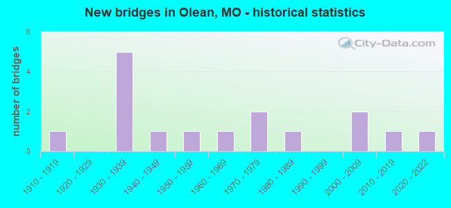
- New bridges - historical statistics
- 11910-1919
- 51930-1939
- 11940-1949
- 11950-1959
- 11960-1969
- 21970-1979
- 11980-1989
- 22000-2009
- 12010-2019
- 12020-2022

- Reconstructed bridges - Historical Statistics
- 21960-1969
- 01970-1979
- 11980-1989


- Bridge Condition - Deck
- 11.1%Excellent
- 22.2%Very good
- 11.1%Good
- 11.1%Satisfactory
- 22.2%Fair
- 22.2%Serious

- Bridge Condition - Superstructure
- 33.3%Excellent
- 22.2%Good
- 11.1%Satisfactory
- 11.1%Fair
- 22.2%Serious

- Bridge Condition - Substructure
- 22.2%Excellent
- 11.1%Very good
- 22.2%Satisfactory
- 22.2%Fair
- 11.1%Poor
- 11.1%Serious

- Bridge Condition - Channel
- 6.3%Very good
- 18.8%Good
- 25.0%Satisfactory
- 43.8%Fair
- 6.3%Serious

- Bridge Condition - Culverts
- 14.3%Good
- 57.1%Satisfactory
- 28.6%Fair
Find on map >> Show street view
Structure Number: 12398, Location: S 3 T 42 N R 15 W (Lat: 38.420167, Lng: -92.567139), Route carried "on" structure: County highway 9, Year Built: 1930, Status: Posted for load, Structure Length: 0.98m (3.22ft), Average Daily Traffic: 25 (year 2021), Truck Traffic: 10%, Average Future Daily Traffic: 43 (year 2041), Features Intersected: TRIB TO S MOREAU C, Facility Carried by Structure: ABBOTT RD
Minimum Vertical Clearance: 30+ m (98+ ft), Kilometerpoint: 0.805, Lanes on structure: 1, Owner: County Highway Agency, Approaching Roadway Width: 5.5m (18.0ft), Material/Design: Steel, Design/Construction: Stringer/Multi-beam, Number Of Spans In Main Unit: 1, Length of Maximum Span: 9.1m (29.9ft), Curb-To-Curb Width: 4.5m (14.8ft), Out-to-Out Width: 4.9m (16.1ft)
Condition: Deck: Satisfactory, Superstructure: Good, Substructure: Fair, Channel: Fair, Operating Rating: 11.7 metric tons, Method Used To Determine Operating Rating: Allowable Stress (AS), Inventory Rating: 3.6 metric tons, Method Used To Determine Inventory Rating: Allowable Stress (AS), Structural Evaluation: High priority of replacement, Deck Geometry: Equal to present minimum criteria, Waterway Adequacy: Better than present minimum criteria, Approach Roadway Alignment: Equal to present desirable criteria, Bridge Posting: Required (Relationship of Operating Rating to Maximum Legal Load: > 39.9% below), Length Of Structure Improvement: 0.17m (0.56ft), Designated Inspection Frequency: Every 24 months, Inspection Date: January 2021, Bridge Improvement Cost: $124,000, Roadway Improvement Cost: $12,000, Total Project Cost: $186,000 ( Estimate for 2022), Deck Structure Type: Concrete Cast-file-Place
Find on map >> Show street view
Structure Number: 125, Location: S 6 T 42 N R 14 W (Lat: 38.427778, Lng: -92.504611), Route carried "on" structure: County highway 12, Year Built: 1930, Status: Posted for load, Structure Length: 1.83m (6.00ft), Average Daily Traffic: 25 (year 2021), Truck Traffic: 10%, Average Future Daily Traffic: 43 (year 2041), Features Intersected: BLYTHES CR, Facility Carried by Structure: SHAW RD
Minimum Vertical Clearance: 30+ m (98+ ft), Kilometerpoint: 0.805, Lanes on structure: 1, Owner: County Highway Agency, Approaching Roadway Width: 4.6m (15.1ft), Material/Design: Steel, Design/Construction: Stringer/Multi-beam, Number Of Spans In Main Unit: 2, Length of Maximum Span: 11.9m (39.0ft), Curb-To-Curb Width: 3.7m (12.1ft), Out-to-Out Width: 3.7m (12.1ft)
Condition: Deck: Fair, Superstructure: Satisfactory, Substructure: Fair, Channel: Fair, Operating Rating: 13.5 metric tons, Method Used To Determine Operating Rating: Allowable Stress (AS), Inventory Rating: 4.5 metric tons, Method Used To Determine Inventory Rating: Allowable Stress (AS), Structural Evaluation: High priority of replacement, Deck Geometry: Meets minimum limits, Waterway Adequacy: Meets minimum limits, Approach Roadway Alignment: Meets minimum limits, Bridge Posting: Required (Relationship of Operating Rating to Maximum Legal Load: > 39.9% below), Length Of Structure Improvement: 0.25m (0.82ft), Designated Inspection Frequency: Every 24 months, Inspection Date: January 2021, Bridge Improvement Cost: $182,000, Roadway Improvement Cost: $18,000, Total Project Cost: $273,000 ( Estimate for 2022), Deck Structure Type: Concrete Cast-file-Place
Find on map >> Show street view
Structure Number: 12894, Location: S 14 T 42 N R 15 W (Lat: 38.403250, Lng: -92.539472), Route carried "on" structure: County highway 23, Year Built: 1930, Status: Open, Structure Length: 1.40m (4.59ft), Average Daily Traffic: 55 (year 2021), Truck Traffic: 10%, Average Future Daily Traffic: 94 (year 2041), Features Intersected: BLYTHES CR, Facility Carried by Structure: OLEAN RD
Minimum Vertical Clearance: 30+ m (98+ ft), Kilometerpoint: 0.805, Lanes on structure: 1, Owner: County Highway Agency, Approaching Roadway Width: 5.2m (17.1ft), Material/Design: Concrete, Design/Construction: Tee Beam, Number Of Spans In Main Unit: 2, Length of Maximum Span: 5.5m (18.0ft), Curb-To-Curb Width: 4.3m (14.1ft), Out-to-Out Width: 4.3m (14.1ft)
Condition: Deck: Fair, Superstructure: Fair, Substructure: Poor, Channel: Fair, Operating Rating: 49.5 metric tons, Method Used To Determine Operating Rating: Allowable Stress (AS), Inventory Rating: 16.2 metric tons, Method Used To Determine Inventory Rating: Allowable Stress (AS), Structural Evaluation: Meets minimum limits, Deck Geometry: Equal to present minimum criteria, Waterway Adequacy: Meets minimum limits, Approach Roadway Alignment: Equal to present minimum criteria, Length Of Structure Improvement: 0.21m (0.69ft), Designated Inspection Frequency: Every 24 months, Inspection Date: January 2021, Bridge Improvement Cost: $153,000, Roadway Improvement Cost: $15,000, Total Project Cost: $230,000 ( Estimate for 2022), Deck Structure Type: Concrete Cast-file-Place
Find on map >> Show street view
Structure Number: 12923, Location: S 12 T 42 N R 15 W (Lat: 38.410000, Lng: -92.526222), Route carried "on" structure: County highway 24, Year Built: 1915, Year Reconstructed: 1972, Status: Posted for load, Structure Length: 1.46m (4.79ft), Average Daily Traffic: 65 (year 2021), Truck Traffic: 10%, Average Future Daily Traffic: 111 (year 2041), Features Intersected: BLYTHES CR, Facility Carried by Structure: BUTTERFIELD STAGE
Minimum Vertical Clearance: 30+ m (98+ ft), Kilometerpoint: 0.161, Lanes on structure: 2, Owner: County Highway Agency, Approaching Roadway Width: 6.1m (20.0ft), Material/Design: Concrete, Design/Construction: Slab, Number Of Spans In Main Unit: 5, Length of Maximum Span: 2.7m (8.9ft), Curb-To-Curb Width: 6.4m (21.0ft), Out-to-Out Width: 6.4m (21.0ft)
Condition: Deck: Serious, Superstructure: Serious, Substructure: Serious, Channel: Serious, Operating Rating: 20.7 metric tons, Method Used To Determine Operating Rating: Field evaluation and documented engineering judgment, Inventory Rating: 13.5 metric tons, Method Used To Determine Inventory Rating: Field evaluation and documented engineering judgment, Structural Evaluation: High priority of corrective action, Deck Geometry: Somewhat better than minimum adequacy, Waterway Adequacy: Meets minimum limits, Approach Roadway Alignment: Equal to present minimum criteria, Bridge Posting: Required (Relationship of Operating Rating to Maximum Legal Load: 10.0 - 19.9% below), Length Of Structure Improvement: 0.21m (0.69ft), Designated Inspection Frequency: Every 24 months, Inspection Date: January 2021, Bridge Improvement Cost: $153,000, Roadway Improvement Cost: $15,000, Total Project Cost: $230,000 ( Estimate for 2022), Deck Structure Type: Concrete Cast-file-Place
Find on map >> Show street view
Structure Number: 2238, Location: S 3119 T 43 N R 7 E (Lat: 38.487203, Lng: -90.283864), Route carried "on" structure: County highway , Year Built: 1976, Status: Open, Structure Length: 1.35m (4.43ft), Average Daily Traffic: 4,433 (year 2021), Truck Traffic: 5%, Average Future Daily Traffic: 6,650 (year 2041), Design Load: HS 20, Features Intersected: MARTIGNEY CR, Facility Carried by Structure: KOCH RD S
Minimum Vertical Clearance: 30+ m (98+ ft), Kilometerpoint: 1.114, Lanes on structure: 4, Owner: State Highway Agency, Approaching Roadway Width: 26.2m (86.0ft), Skew: 13 degrees, Material/Design: Concrete continuous, Design/Construction: Culvert, Number Of Spans In Main Unit: 3, Length of Maximum Span: 3.7m (12.1ft)
Condition: Channel: Fair, Culverts: Satisfactory, Operating Rating: 87.3 metric tons, Method Used To Determine Operating Rating: Field evaluation and documented engineering judgment, Inventory Rating: 52.2 metric tons, Method Used To Determine Inventory Rating: Field evaluation and documented engineering judgment, Structural Evaluation: Equal to present minimum criteria, Waterway Adequacy: Equal to present desirable criteria, Approach Roadway Alignment: Equal to present desirable criteria, Designated Inspection Frequency: Every 24 months, Inspection Date: November 2021
Find on map >> Show street view
Structure Number: 251, Location: S 29 T 42 N R 14 W (Lat: 38.367808, Lng: -92.498236), Route carried "on" structure: US 54, Year Built: 1975, Status: Open, Structure Length: 0.85m (2.79ft), Average Daily Traffic: 6,196 (year 2021), Truck Traffic: 15%, Average Future Daily Traffic: 10,843 (year 2041), Design Load: HS 20, Features Intersected: BRUSH CR
Minimum Vertical Clearance: 30+ m (98+ ft), Kilometerpoint: 206.428, Lanes on structure: 2, Base Highway Network: Yes, Owner: State Highway Agency, Approaching Roadway Width: 11.0m (36.1ft), Skew: 1 degrees, Material/Design: Concrete continuous, Design/Construction: Culvert, Number Of Spans In Main Unit: 2, Length of Maximum Span: 4.0m (13.1ft), Curb-To-Curb Width: 27.4m (89.9ft), Out-to-Out Width: 28.0m (91.9ft)
Condition: Channel: Good, Culverts: Satisfactory, Inventory Rating: 80.1 metric tons, Method Used To Determine Inventory Rating: Load Factor (LF), Structural Evaluation: Equal to present minimum criteria, Deck Geometry: Superior to present desirable criteria, Waterway Adequacy: Equal to present desirable criteria, Approach Roadway Alignment: Equal to present desirable criteria, Designated Inspection Frequency: Every 24 months, Inspection Date: November 2020
Find on map >> Show street view
Structure Number: 30592, Location: S 1 T 42 N R 15 W (Lat: 38.425619, Lng: -92.532364), Route carried "on" structure: County highway 11, Year Built: 2004, Status: Open, Structure Length: 5.94m (19.49ft), Average Daily Traffic: 25 (year 2021), Truck Traffic: 10%, Average Future Daily Traffic: 43 (year 2041), Design Load: HS 20+Mod, Features Intersected: S MOREAU CR, Facility Carried by Structure: SOUTH CREEK RD
Minimum Vertical Clearance: 30+ m (98+ ft), Kilometerpoint: 0.000, Lanes on structure: 2, Owner: County Highway Agency, Approaching Roadway Width: 7.3m (24.0ft), Skew: 3 degrees, Material/Design: Prestressed concrete continuous, Design/Construction: Stringer/Multi-beam, Number Of Spans In Main Unit: 3, Length of Maximum Span: 21.3m (69.9ft), Curb-To-Curb Width: 7.3m (24.0ft), Out-to-Out Width: 7.9m (25.9ft)
Condition: Deck: Very good, Superstructure: Excellent, Substructure: Very good, Channel: Fair, Operating Rating: 71.1 metric tons, Method Used To Determine Operating Rating: Load Factor (LF), Inventory Rating: 43.2 metric tons, Method Used To Determine Inventory Rating: Load Factor (LF), Structural Evaluation: Equal to present desirable criteria, Deck Geometry: Equal to present minimum criteria, Waterway Adequacy: Better than present minimum criteria, Approach Roadway Alignment: Equal to present desirable criteria, Designated Inspection Frequency: Every 24 months, Inspection Date: January 2021, Deck Structure Type: Concrete Precast Panels, Wearing Surface/Protective System: Wearing Surface: Monolithic Concrete
Find on map >> Show street view
Structure Number: 31456, Location: S 16 T 42 N R 14 W (Lat: 38.393333, Lng: -92.466667), Route carried "on" structure: County highway , Year Built: 2006, Status: Open, Structure Length: 3.20m (10.50ft), Average Daily Traffic: 15 (year 2021), Truck Traffic: 10%, Average Future Daily Traffic: 26 (year 2041), Design Load: HS 20, Features Intersected: BRUSH CR, Facility Carried by Structure: SPRING GARDEN RD
Minimum Vertical Clearance: 30+ m (98+ ft), Kilometerpoint: 2.092, Lanes on structure: 2, Owner: County Highway Agency, Approaching Roadway Width: 7.3m (24.0ft), Skew: 2 degrees, Material/Design: Prestressed concrete, Design/Construction: Stringer/Multi-beam, Number Of Spans In Main Unit: 1, Length of Maximum Span: 31.1m (102.0ft), Curb-To-Curb Width: 7.3m (24.0ft), Out-to-Out Width: 8.0m (26.2ft)
Condition: Deck: Very good, Superstructure: Excellent, Substructure: Excellent, Channel: Satisfactory, Operating Rating: 68.4 metric tons, Method Used To Determine Operating Rating: Load Factor (LF), Inventory Rating: 41.4 metric tons, Method Used To Determine Inventory Rating: Load Factor (LF), Structural Evaluation: Superior to present desirable criteria, Deck Geometry: Equal to present minimum criteria, Waterway Adequacy: Better than present minimum criteria, Approach Roadway Alignment: Equal to present desirable criteria, Designated Inspection Frequency: Every 24 months, Inspection Date: January 2021, Deck Structure Type: Concrete Cast-file-Place
Find on map >> Show street view
Structure Number: 3494, Location: S 6 T 25 N R 16 E (Lat: 36.847900, Lng: -89.362350), Route carried "on" structure: State highway C, Year Built: 2015, Status: Open, Structure Length: 1.36m (4.46ft), Average Daily Traffic: 700 (year 2021), Truck Traffic: 16%, Average Future Daily Traffic: 980 (year 2041), Features Intersected: DRAIN DTCH #14
Minimum Vertical Clearance: 30+ m (98+ ft), Kilometerpoint: 8.275, Lanes on structure: 2, Owner: State Highway Agency, Approaching Roadway Width: 7.3m (24.0ft), Material/Design: Concrete continuous, Design/Construction: Culvert, Number Of Spans In Main Unit: 3, Length of Maximum Span: 4.3m (14.1ft), Out-to-Out Width: 7.3m (24.0ft)
Condition: Channel: Good, Culverts: Good, Inventory Rating: 82.8 metric tons, Method Used To Determine Inventory Rating: Load Factor (LF), Structural Evaluation: Better than present minimum criteria, Waterway Adequacy: Superior to present desirable criteria, Approach Roadway Alignment: Equal to present desirable criteria, Designated Inspection Frequency: Every 24 months, Inspection Date: November 2021
Find on map >> Show street view
Structure Number: 3508, Location: S 33 T 59 N R 32 W (Lat: 39.892900, Lng: -94.502369), Route carried "on" structure: State highway 6, Year Built: 1984, Status: Open, Structure Length: 4.54m (14.90ft), Average Daily Traffic: 1,054 (year 2021), Truck Traffic: 10%, Average Future Daily Traffic: 1,423 (year 2041), Design Load: H 20, Features Intersected: N FK LOST CAMP CR
Minimum Vertical Clearance: 30+ m (98+ ft), Kilometerpoint: 39.080, Lanes on structure: 2, Base Highway Network: Yes, Owner: State Highway Agency, Approaching Roadway Width: 10.4m (34.1ft), Material/Design: Prestressed concrete continuous, Design/Construction: Tee Beam, Number Of Spans In Main Unit: 4, Length of Maximum Span: 11.5m (37.7ft), Curb or Sidewalk Widths: Left: 0.2m (0.7ft), Right: 0.2m (0.7ft), Curb-To-Curb Width: 10.0m (32.8ft), Out-to-Out Width: 10.8m (35.4ft)
Condition: Deck: Good, Superstructure: Good, Substructure: Satisfactory, Channel: Fair, Operating Rating: 54.0 metric tons, Method Used To Determine Operating Rating: Load Factor (LF), Inventory Rating: 32.4 metric tons, Method Used To Determine Inventory Rating: Load Factor (LF), Structural Evaluation: Equal to present minimum criteria, Deck Geometry: Somewhat better than minimum adequacy, Waterway Adequacy: Somewhat better than minimum adequacy, Approach Roadway Alignment: Equal to present desirable criteria, Designated Inspection Frequency: Every 24 months, Inspection Date: December 2021, Deck Structure Type: Concrete Cast-file-Place, Wearing Surface/Protective System: Wearing Surface: Monolithic Concrete, Deck Protection: Epoxy Coated Reinforcing
Find on map >> Show street view
Structure Number: 36469, Location: S 12 T 42 N R 15 W (Lat: 38.409939, Lng: -92.526069), Route carried "on" structure: County highway 24, Year Built: 2020, Status: Not yet open, Structure Length: 4.72m (15.49ft), Average Daily Traffic: 65 (year 2021), Truck Traffic: 10%, Average Future Daily Traffic: 111 (year 2041), Features Intersected: BLYTHE CREEK, Facility Carried by Structure: BUTTERFIELD STAGE
Minimum Vertical Clearance: 30+ m (98+ ft), Kilometerpoint: 0.161, Lanes on structure: 2, Owner: County Highway Agency, Approaching Roadway Width: 7.3m (24.0ft), Material/Design: Prestressed concrete continuous, Design/Construction: Box Beam or Girders - Multiple, Number Of Spans In Main Unit: 4, Length of Maximum Span: 11.7m (38.4ft), Curb-To-Curb Width: 7.7m (25.3ft), Out-to-Out Width: 7.8m (25.6ft)
Condition: Deck: Excellent, Superstructure: Excellent, Substructure: Excellent, Channel: Very good, Operating Rating: 54.0 metric tons, Method Used To Determine Operating Rating: Load Factor (LF), Inventory Rating: 32.4 metric tons, Method Used To Determine Inventory Rating: Load Factor (LF), Structural Evaluation: Equal to present desirable criteria, Deck Geometry: Equal to present minimum criteria, Waterway Adequacy: Equal to present minimum criteria, Approach Roadway Alignment: Equal to present desirable criteria, Designated Inspection Frequency: Every 24 months, Inspection Date: November 2020, Deck Structure Type: Concrete Cast-file-Place, Wearing Surface/Protective System: Wearing Surface: Other, Deck Protection: Epoxy Coated Reinforcing
Find on map >> Show street view
Structure Number: 4572, Location: S 29 T 42 N R 14 W (Lat: 38.367386, Lng: -92.498358), Route carried "on" structure: US 54, Year Built: 1932, Year Reconstructed: 1973, Status: Open, Structure Length: 0.66m (2.17ft), Average Daily Traffic: 5,814 (year 2021), Truck Traffic: 12%, Average Future Daily Traffic: 10,175 (year 2041), Design Load: H 15, Features Intersected: BRUSH CR
Minimum Vertical Clearance: 30+ m (98+ ft), Kilometerpoint: 231.017, Lanes on structure: 2, Base Highway Network: Yes, Owner: State Highway Agency, Approaching Roadway Width: 13.4m (44.0ft), Skew: 1 degrees, Material/Design: Concrete continuous, Design/Construction: Culvert, Number Of Spans In Main Unit: 2, Length of Maximum Span: 3.0m (9.8ft)
Condition: Channel: Good, Culverts: Satisfactory, Operating Rating: 74.7 metric tons, Method Used To Determine Operating Rating: Load Factor (LF), Inventory Rating: 45.0 metric tons, Method Used To Determine Inventory Rating: Load Factor (LF), Structural Evaluation: Equal to present minimum criteria, Waterway Adequacy: Equal to present desirable criteria, Approach Roadway Alignment: Equal to present desirable criteria, Designated Inspection Frequency: Every 24 months, Inspection Date: November 2020
Find on map >> Show street view
Structure Number: 567, Location: S 3 T 57 N R 20 W (Lat: 39.779511, Lng: -93.122422), Route carried "on" structure: US 36, Year Built: 1961, Year Reconstructed: 1991, Status: Open, Structure Length: 0.88m (2.89ft), Average Daily Traffic: 9,590 (year 2021), Truck Traffic: 41%, Average Future Daily Traffic: 16,783 (year 2041), Design Load: H 20, Features Intersected: LIT TURKEY CR
Minimum Vertical Clearance: 30+ m (98+ ft), Kilometerpoint: 152.299, Lanes on structure: 4, Base Highway Network: Yes, Owner: State Highway Agency, Approaching Roadway Width: 13.4m (44.0ft), Material/Design: Concrete continuous, Design/Construction: Culvert, Number Of Spans In Main Unit: 2, Length of Maximum Span: 4.3m (14.1ft)
Condition: Channel: Satisfactory, Culverts: Fair, Operating Rating: 72.0 metric tons, Method Used To Determine Operating Rating: Field evaluation and documented engineering judgment, Inventory Rating: 43.2 metric tons, Method Used To Determine Inventory Rating: Field evaluation and documented engineering judgment, Structural Evaluation: Somewhat better than minimum adequacy, Waterway Adequacy: Equal to present minimum criteria, Approach Roadway Alignment: Equal to present desirable criteria, Designated Inspection Frequency: Every 24 months, Inspection Date: December 2020
Find on map >> Show street view
Structure Number: 5967, Location: S 24 T 43 N R 15 W (Lat: 38.459075, Lng: -92.514642), Route carried "on" structure: State highway A, Year Built: 1939, Status: Open, Structure Length: 3.44m (11.29ft), Average Daily Traffic: 271 (year 2021), Truck Traffic: 12%, Average Future Daily Traffic: 393 (year 2041), Design Load: H 15, Features Intersected: ENON CR
Minimum Vertical Clearance: 30+ m (98+ ft), Kilometerpoint: 3.496, Lanes on structure: 2, Owner: State Highway Agency, Approaching Roadway Width: 6.1m (20.0ft), Skew: 3 degrees, Material/Design: Concrete, Design/Construction: Tee Beam, Number Of Spans In Main Unit: 3, Length of Maximum Span: 14.5m (47.6ft), Curb-To-Curb Width: 7.3m (24.0ft), Out-to-Out Width: 8.4m (27.6ft)
Condition: Deck: Serious, Superstructure: Serious, Substructure: Satisfactory, Channel: Satisfactory, Operating Rating: 31.5 metric tons, Method Used To Determine Operating Rating: Load Factor (LF), Inventory Rating: 18.9 metric tons, Method Used To Determine Inventory Rating: Load Factor (LF), Structural Evaluation: High priority of corrective action, Deck Geometry: Somewhat better than minimum adequacy, Waterway Adequacy: Equal to present desirable criteria, Approach Roadway Alignment: Equal to present minimum criteria, Length Of Structure Improvement: 0.43m (1.41ft), Designated Inspection Frequency: Every 24 months, Inspection Date: June 2021, Bridge Improvement Cost: $440,000, Roadway Improvement Cost: $44,000, Total Project Cost: $660,000 ( Estimate for 2022), Deck Structure Type: Concrete Cast-file-Place, Wearing Surface/Protective System: Wearing Surface: Bituminous
Find on map >> Show street view
Structure Number: 6711, Location: S 24 T 43 N R 15 W (Lat: 38.464558, Lng: -92.519286), Route carried "on" structure: State highway V, Year Built: 1955, Status: Open, Structure Length: 1.52m (4.99ft), Average Daily Traffic: 408 (year 2021), Truck Traffic: 14%, Average Future Daily Traffic: 592 (year 2041), Design Load: H 10, Features Intersected: ENON CR
Minimum Vertical Clearance: 30+ m (98+ ft), Kilometerpoint: 7.228, Lanes on structure: 2, Owner: State Highway Agency, Approaching Roadway Width: 7.3m (24.0ft), Material/Design: Concrete continuous, Design/Construction: Culvert, Number Of Spans In Main Unit: 4, Length of Maximum Span: 3.7m (12.1ft), Curb-To-Curb Width: 8.4m (27.6ft), Out-to-Out Width: 9.0m (29.5ft)
Condition: Channel: Fair, Culverts: Fair, Operating Rating: 35.1 metric tons, Method Used To Determine Operating Rating: Load Factor (LF), Inventory Rating: 20.7 metric tons, Method Used To Determine Inventory Rating: Load Factor (LF), Structural Evaluation: Somewhat better than minimum adequacy, Deck Geometry: Somewhat better than minimum adequacy, Waterway Adequacy: Equal to present desirable criteria, Approach Roadway Alignment: Equal to present minimum criteria, Designated Inspection Frequency: Every 24 months, Inspection Date: June 2021
Find on map >> Show street view
Structure Number: 9644, Location: S 23 T 43 N R 15 W (Lat: 38.458006, Lng: -92.535031), Route carried "on" structure: State highway A, Year Built: 1941, Status: Open, Structure Length: 0.67m (2.20ft), Average Daily Traffic: 418 (year 2021), Truck Traffic: 7%, Average Future Daily Traffic: 606 (year 2041), Design Load: H 10, Features Intersected: HODEL BR
Minimum Vertical Clearance: 30+ m (98+ ft), Kilometerpoint: 1.714, Lanes on structure: 2, Owner: State Highway Agency, Approaching Roadway Width: 7.3m (24.0ft), Skew: 2 degrees, Material/Design: Concrete continuous, Design/Construction: Culvert, Number Of Spans In Main Unit: 2, Length of Maximum Span: 3.0m (9.8ft), Curb-To-Curb Width: 8.1m (26.6ft), Out-to-Out Width: 8.7m (28.5ft)
Condition: Channel: Satisfactory, Culverts: Satisfactory, Operating Rating: 39.6 metric tons, Method Used To Determine Operating Rating: Load Factor (LF), Inventory Rating: 24.3 metric tons, Method Used To Determine Inventory Rating: Load Factor (LF), Structural Evaluation: Equal to present minimum criteria, Deck Geometry: Somewhat better than minimum adequacy, Waterway Adequacy: Equal to present desirable criteria, Approach Roadway Alignment: Equal to present minimum criteria, Designated Inspection Frequency: Every 24 months, Inspection Date: June 2021