Bridge Statistics for Olean, New York (NY)
Condition, Traffic, Stress, Structural Evaluation, Project Costs
- National Bridge Inventory (NBI) Statistics
- 37Number of bridges
- 502ft / 153mTotal length
- $142,098,000Total costs
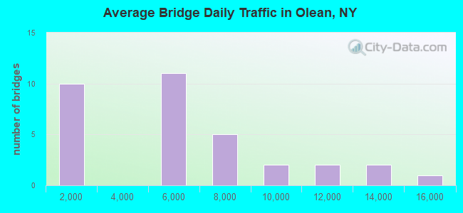
- 168,579Total average daily traffic
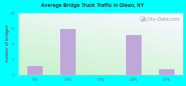
- 17,559Total average daily truck traffic
- National Bridge Inventory (NBI) Registered Bridges for Olean
- No street view available for this location
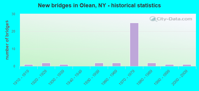
- New bridges - historical statistics
- 11910-1919
- 21920-1929
- 11930-1939
- 21950-1959
- 21960-1969
- 251970-1979
- 21980-1989
- 11990-1999
- 12000-2009
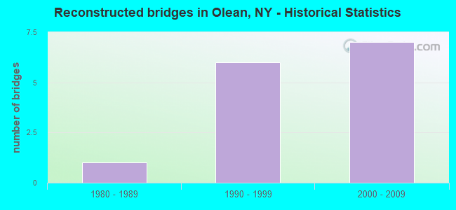
- Reconstructed bridges - Historical Statistics
- 11980-1989
- 61990-1999
- 72000-2009
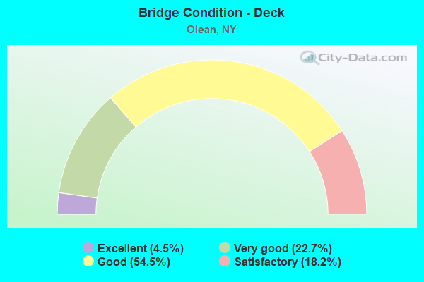
- Bridge Condition - Deck
- 4.5%Excellent
- 22.7%Very good
- 54.5%Good
- 18.2%Satisfactory
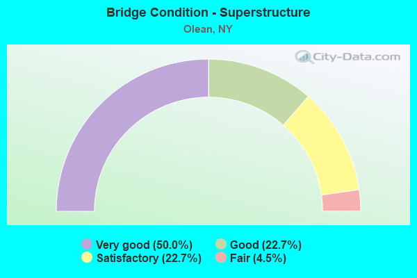
- Bridge Condition - Superstructure
- 50.0%Very good
- 22.7%Good
- 22.7%Satisfactory
- 4.5%Fair
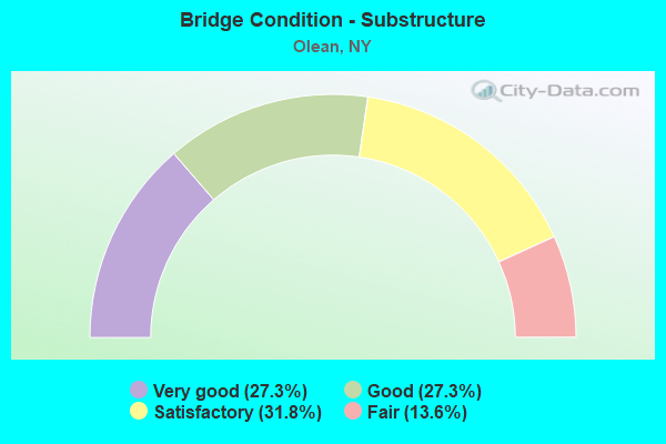
- Bridge Condition - Substructure
- 27.3%Very good
- 27.3%Good
- 31.8%Satisfactory
- 13.6%Fair
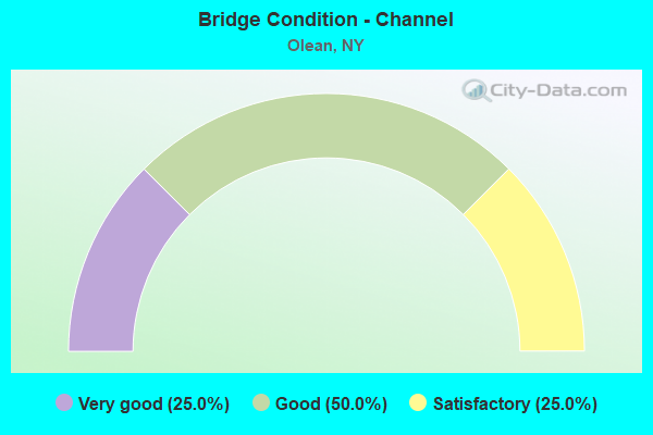
- Bridge Condition - Channel
- 25.0%Very good
- 50.0%Good
- 25.0%Satisfactory
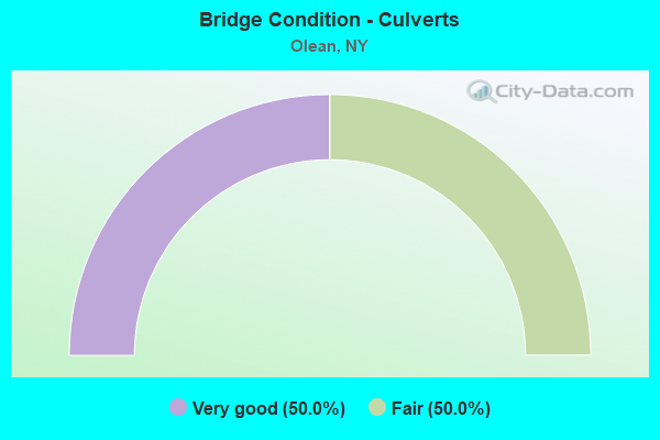
- Bridge Condition - Culverts
- 50.0%Very good
- 50.0%Fair
Find on map >> Show street view
Structure Number: 101164, Location: JCT RTE 16 + ALLEGHENY R (Lat: 42.069992, Lng: -78.429978), Route carried "on" structure: State highway 16, Year Built: 1955, Year Reconstructed: 1995, Status: Open, Structure Length: 16.22m (53.22ft), Average Daily Traffic: 4,482 (year 2020), Truck Traffic: 4%, Average Future Daily Traffic: 4,732 (year 2040), Design Load: HS 25 or greater, Features Intersected: ALLEGHENY RIVER
Minimum Vertical Clearance: 30+ m (98+ ft), Kilometerpoint: 13.226, Lanes on structure: 2, Base Highway Network: Yes, Owner: State Highway Agency, Approaching Roadway Width: 9.1m (29.9ft), Material/Design: Steel continuous, Design/Construction: Stringer/Multi-beam, Number Of Spans In Main Unit: 5, Length of Maximum Span: 38.1m (125.0ft), Curb or Sidewalk Widths: Left: 2.0m (6.6ft), Right: 2.0m (6.6ft), Curb-To-Curb Width: 8.5m (27.9ft), Out-to-Out Width: 13.1m (43.0ft)
Condition: Deck: Good, Superstructure: Very good, Substructure: Fair, Channel: Very good, Operating Rating: 51.7 metric tons, Method Used To Determine Operating Rating: Load Factor (LF), Inventory Rating: 30.8 metric tons, Method Used To Determine Inventory Rating: Load Factor (LF), Structural Evaluation: Somewhat better than minimum adequacy, Deck Geometry: Meets minimum limits, Waterway Adequacy: Somewhat better than minimum adequacy, Approach Roadway Alignment: Equal to present desirable criteria, Length Of Structure Improvement: 16.21m (53.18ft), Designated Inspection Frequency: Every 24 months, Inspection Date: October 2020, Bridge Improvement Cost: $7,325,000, Roadway Improvement Cost: $4,290,000, Total Project Cost: $11,615,000 ( Estimate for 2021), Deck Structure Type: Concrete Cast-file-Place, Wearing Surface/Protective System: Wearing Surface: Integral Concrete, Deck Protection: Epoxy Coated Reinforcing
Find on map >> Show street view
Structure Number: 1011659, Location: 1.28 KM N JCT RTS 16&417 (Lat: 42.088328, Lng: -78.429878), Route carried "on" structure: State highway 16, Year Built: 1966, Year Reconstructed: 1998, Status: Open, Structure Length: 6.22m (20.41ft), Average Daily Traffic: 8,249 (year 2018), Truck Traffic: 6%, Average Future Daily Traffic: 8,287 (year 2040), Design Load: HS 25 or greater, Features Intersected: OLEAN CREEK
Minimum Vertical Clearance: 30+ m (98+ ft), Kilometerpoint: 15.318, Lanes on structure: 4, Base Highway Network: Yes, Owner: State Highway Agency, Approaching Roadway Width: 21.6m (70.9ft), Skew: 20 degrees, Material/Design: Steel continuous, Design/Construction: Stringer/Multi-beam, Number Of Spans In Main Unit: 2, Length of Maximum Span: 30.4m (99.7ft), Curb-To-Curb Width: 21.6m (70.9ft), Out-to-Out Width: 22.2m (72.8ft)
Condition: Deck: Good, Superstructure: Very good, Substructure: Good, Channel: Good, Operating Rating: 74.4 metric tons, Method Used To Determine Operating Rating: Load Factor (LF), Inventory Rating: 44.5 metric tons, Method Used To Determine Inventory Rating: Load Factor (LF), Structural Evaluation: Better than present minimum criteria, Deck Geometry: Superior to present desirable criteria, Waterway Adequacy: Equal to present minimum criteria, Approach Roadway Alignment: Equal to present desirable criteria, Length Of Structure Improvement: 6.21m (20.37ft), Designated Inspection Frequency: Every 24 months, Inspection Date: June 2020, Bridge Improvement Cost: $5,581,000, Roadway Improvement Cost: $3,268,000, Total Project Cost: $8,849,000 ( Estimate for 2021), Deck Structure Type: Concrete Cast-file-Place, Wearing Surface/Protective System: Wearing Surface: Integral Concrete, Deck Protection: Epoxy Coated Reinforcing
Find on map >> Show street view
Structure Number: 101166, Location: 2.2 MI N JCT SH16 & SH417 (Lat: 42.106697, Lng: -78.417953), Route carried "on" structure: State highway 16, Year Built: 1995, Status: Open, Structure Length: 9.33m (30.61ft), Average Daily Traffic: 4,501 (year 2019), Truck Traffic: 6%, Average Future Daily Traffic: 5,569 (year 2040), Design Load: HS 25 or greater, Features Intersected: WESTERN NY & PENN
Minimum Vertical Clearance: 30+ m (98+ ft), Kilometerpoint: 17.586, Lanes on structure: 2, Base Highway Network: Yes, Owner: State Highway Agency, Approaching Roadway Width: 12.2m (40.0ft), Skew: 3 degrees, Material/Design: Steel continuous, Design/Construction: Stringer/Multi-beam, Number Of Spans In Main Unit: 3, Length of Maximum Span: 42.6m (139.8ft), Curb-To-Curb Width: 12.2m (40.0ft), Out-to-Out Width: 13.0m (42.7ft)
Condition: Deck: Very good, Superstructure: Very good, Substructure: Good, Operating Rating: 88.0 metric tons, Method Used To Determine Operating Rating: Load Factor (LF), Inventory Rating: 52.6 metric tons, Method Used To Determine Inventory Rating: Load Factor (LF), Structural Evaluation: Better than present minimum criteria, Deck Geometry: Equal to present minimum criteria, Underclear: Equal to present minimum criteria, Approach Roadway Alignment: Equal to present desirable criteria, Length Of Structure Improvement: 9.32m (30.58ft), Designated Inspection Frequency: Every 24 months, Inspection Date: August 2021, Bridge Improvement Cost: $4,484,000, Roadway Improvement Cost: $2,626,000, Total Project Cost: $7,110,000 ( Estimate for 2021), Deck Structure Type: Concrete Cast-file-Place, Wearing Surface/Protective System: Wearing Surface: Integral Concrete, Deck Protection: Epoxy Coated Reinforcing
Find on map >> Show street view
Structure Number: 101167, Location: 2.5 MI N JCT RTS 16 + 417 (Lat: 42.110844, Lng: -78.417117), Route carried "on" structure: State highway 16, Year Built: 1937, Status: Open, Structure Length: 0.82m (2.69ft), Average Daily Traffic: 4,501 (year 2019), Truck Traffic: 6%, Average Future Daily Traffic: 5,569 (year 2040), Features Intersected: BRANCH OLEAN CRK
Minimum Vertical Clearance: 30+ m (98+ ft), Kilometerpoint: 18.101, Lanes on structure: 3, Base Highway Network: Yes, Owner: State Highway Agency, Approaching Roadway Width: 14.6m (47.9ft), Skew: 4 degrees, Material/Design: Concrete, Design/Construction: Slab, Number Of Spans In Main Unit: 1, Length of Maximum Span: 7.9m (25.9ft), Curb-To-Curb Width: 14.0m (45.9ft), Out-to-Out Width: 16.2m (53.1ft)
Condition: Deck: Satisfactory, Superstructure: Satisfactory, Substructure: Fair, Channel: Satisfactory, Operating Rating: 64.4 metric tons, Method Used To Determine Operating Rating: Load Factor (LF), Inventory Rating: 39.0 metric tons, Method Used To Determine Inventory Rating: Load Factor (LF), Structural Evaluation: Somewhat better than minimum adequacy, Deck Geometry: Somewhat better than minimum adequacy, Waterway Adequacy: Equal to present desirable criteria, Approach Roadway Alignment: Equal to present desirable criteria, Length Of Structure Improvement: 0.82m (2.69ft), Designated Inspection Frequency: Every 24 months, Inspection Date: April 2020, Bridge Improvement Cost: $587,000, Roadway Improvement Cost: $344,000, Total Project Cost: $931,000 ( Estimate for 2021), Wearing Surface/Protective System: Wearing Surface: Bituminous, Membrane: Other
Find on map >> Show street view
Structure Number: 1092051, Location: ON RTE 17 IN OLEAN N.Y. (Lat: 42.089956, Lng: -78.452969), Route carried "on" structure: Interstate 86, Year Built: 1973, Year Reconstructed: 2007, Status: Open, Structure Length: 4.97m (16.31ft), Average Daily Traffic: 6,157 (year 2014), Truck Traffic: 19%, Design Load: HL 93, Features Intersected: Buffalo St.
Minimum Vertical Clearance: 30+ m (98+ ft), Kilometerpoint: 63.507, Lanes on structure: 2, Lanes under structure: 4, Base Highway Network: Yes, Owner: State Highway Agency, Approaching Roadway Width: 11.0m (36.1ft), Skew: 2 degrees, Material/Design: Steel continuous, Design/Construction: Stringer/Multi-beam, Number Of Spans In Main Unit: 2, Length of Maximum Span: 24.1m (79.1ft), Curb-To-Curb Width: 12.0m (39.4ft), Out-to-Out Width: 13.0m (42.7ft)
Condition: Deck: Good, Superstructure: Very good, Substructure: Good, Operating Rating: 76.2 metric tons, Method Used To Determine Operating Rating: Load Factor (LF), Inventory Rating: 45.4 metric tons, Method Used To Determine Inventory Rating: Load Factor (LF), Structural Evaluation: Better than present minimum criteria, Deck Geometry: Equal to present minimum criteria, Underclear: Better than present minimum criteria, Approach Roadway Alignment: Equal to present desirable criteria, Length Of Structure Improvement: 4.96m (16.27ft), Designated Inspection Frequency: Every 24 months, Inspection Date: September 2021, Bridge Improvement Cost: $3,194,000, Roadway Improvement Cost: $1,871,000, Total Project Cost: $5,065,000 ( Estimate for 2021), Deck Structure Type: Concrete Cast-file-Place, Wearing Surface/Protective System: Wearing Surface: Integral Concrete, Deck Protection: Epoxy Coated Reinforcing
Find on map >> Show street view
Structure Number: 1092052, Location: ON RTE 17 IN OLEAN N.Y. (Lat: 42.089822, Lng: -78.452725), Route carried "on" structure: Interstate 86, Year Built: 1973, Year Reconstructed: 2006, Status: Open, Structure Length: 4.88m (16.01ft), Average Daily Traffic: 4,335 (year 2019), Truck Traffic: 17%, Average Future Daily Traffic: 4,857 (year 2040), Design Load: HS 20, Features Intersected: BUFFALO STREET
Minimum Vertical Clearance: 30+ m (98+ ft), Kilometerpoint: 63.491, Lanes on structure: 2, Lanes under structure: 5, Base Highway Network: Yes, Owner: State Highway Agency, Approaching Roadway Width: 11.9m (39.0ft), Skew: 1 degrees, Material/Design: Steel continuous, Design/Construction: Stringer/Multi-beam, Number Of Spans In Main Unit: 2, Length of Maximum Span: 24.0m (78.7ft), Curb-To-Curb Width: 12.0m (39.4ft), Out-to-Out Width: 13.0m (42.7ft)
Condition: Deck: Good, Superstructure: Very good, Substructure: Good, Operating Rating: 76.2 metric tons, Method Used To Determine Operating Rating: Load Factor (LF), Inventory Rating: 45.4 metric tons, Method Used To Determine Inventory Rating: Load Factor (LF), Structural Evaluation: Better than present minimum criteria, Deck Geometry: Equal to present minimum criteria, Underclear: Equal to present minimum criteria, Approach Roadway Alignment: Equal to present desirable criteria, Length Of Structure Improvement: 4.87m (15.98ft), Designated Inspection Frequency: Every 24 months, Inspection Date: September 2021, Bridge Improvement Cost: $3,122,000, Roadway Improvement Cost: $1,828,000, Total Project Cost: $4,950,000 ( Estimate for 2021), Deck Structure Type: Concrete Cast-file-Place, Wearing Surface/Protective System: Wearing Surface: Integral Concrete
Find on map >> Show street view
Structure Number: 1092061, Location: ON RTE 17 IN OLEAN N.Y. (Lat: 42.094344, Lng: -78.446600), Route carried "on" structure: Interstate 86, Year Built: 1973, Year Reconstructed: 2007, Status: Open, Structure Length: 3.11m (10.20ft), Average Daily Traffic: 6,157 (year 2014), Truck Traffic: 17%, Average Future Daily Traffic: 11,615 (year 2031), Design Load: HL 93, Features Intersected: Johnson St.
Minimum Vertical Clearance: 30+ m (98+ ft), Kilometerpoint: 64.215, Lanes on structure: 2, Lanes under structure: 2, Base Highway Network: Yes, Owner: State Highway Agency, Approaching Roadway Width: 11.9m (39.0ft), Material/Design: Steel, Design/Construction: Stringer/Multi-beam, Number Of Spans In Main Unit: 1, Length of Maximum Span: 29.9m (98.1ft), Curb-To-Curb Width: 12.0m (39.4ft), Out-to-Out Width: 13.0m (42.7ft)
Condition: Deck: Very good, Superstructure: Very good, Substructure: Very good, Operating Rating: 96.2 metric tons, Method Used To Determine Operating Rating: Load Factor (LF), Inventory Rating: 57.2 metric tons, Method Used To Determine Inventory Rating: Load Factor (LF), Structural Evaluation: Equal to present desirable criteria, Deck Geometry: Equal to present minimum criteria, Underclear: Better than present minimum criteria, Approach Roadway Alignment: Equal to present desirable criteria, Length Of Structure Improvement: 3.10m (10.17ft), Designated Inspection Frequency: Every 24 months, Inspection Date: September 2020, Bridge Improvement Cost: $2,204,000, Roadway Improvement Cost: $1,291,000, Total Project Cost: $3,494,000 ( Estimate for 2021), Deck Structure Type: Concrete Cast-file-Place, Wearing Surface/Protective System: Wearing Surface: Integral Concrete, Deck Protection: Epoxy Coated Reinforcing
Find on map >> Show street view
Structure Number: 1092062, Location: ON RTE 17 IN OLEAN N.Y. (Lat: 42.094219, Lng: -78.446381), Route carried "on" structure: Interstate 86, Year Built: 1973, Year Reconstructed: 2006, Status: Open, Structure Length: 3.11m (10.20ft), Average Daily Traffic: 4,335 (year 2019), Truck Traffic: 16%, Average Future Daily Traffic: 4,857 (year 2040), Design Load: HL 93, Features Intersected: JOHNSON STREET
Minimum Vertical Clearance: 30+ m (98+ ft), Kilometerpoint: 64.199, Lanes on structure: 2, Lanes under structure: 2, Base Highway Network: Yes, Owner: State Highway Agency, Approaching Roadway Width: 12.2m (40.0ft), Material/Design: Steel, Design/Construction: Stringer/Multi-beam, Number Of Spans In Main Unit: 1, Length of Maximum Span: 29.9m (98.1ft), Curb-To-Curb Width: 12.2m (40.0ft), Out-to-Out Width: 12.8m (42.0ft)
Condition: Deck: Very good, Superstructure: Very good, Substructure: Very good, Operating Rating: 84.9 metric tons, Method Used To Determine Operating Rating: Load and Resistance Factor Rating (LRFR) rating reported by rating factor(RF) method using HL-93 loadings, Inventory Rating: 65.4 metric tons, Method Used To Determine Inventory Rating: Load and Resistance Factor Rating (LRFR) rating reported by rating factor(RF) method using HL-93 loadings, Structural Evaluation: Equal to present desirable criteria, Deck Geometry: Better than present minimum criteria, Underclear: Equal to present minimum criteria, Approach Roadway Alignment: Equal to present desirable criteria, Length Of Structure Improvement: 3.10m (10.17ft), Designated Inspection Frequency: Every 24 months, Inspection Date: September 2020, Bridge Improvement Cost: $2,168,000, Roadway Improvement Cost: $1,269,000, Total Project Cost: $3,437,000 ( Estimate for 2021), Deck Structure Type: Concrete Cast-file-Place, Wearing Surface/Protective System: Wearing Surface: Integral Concrete, Deck Protection: Epoxy Coated Reinforcing
Find on map >> Show street view
Structure Number: 1092071, Location: IN NORTH OLEAN (Lat: 42.097808, Lng: -78.441017), Route carried "on" structure: Interstate 86, Year Built: 1973, Year Reconstructed: 1996, Status: Open, Structure Length: 11.52m (37.80ft), Average Daily Traffic: 6,157 (year 2014), Truck Traffic: 17%, Design Load: HS 20, Features Intersected: WNY&PA RR
Minimum Vertical Clearance: 30+ m (98+ ft), Kilometerpoint: 64.730, Lanes on structure: 2, Base Highway Network: Yes, Owner: State Highway Agency, Approaching Roadway Width: 12.5m (41.0ft), Skew: 6 degrees, Material/Design: Steel, Design/Construction: Stringer/Multi-beam, Number Of Spans In Main Unit: 3, Length of Maximum Span: 39.3m (128.9ft), Curb-To-Curb Width: 12.5m (41.0ft), Out-to-Out Width: 13.7m (44.9ft)
Condition: Deck: Very good, Superstructure: Good, Substructure: Satisfactory, Operating Rating: 53.8 metric tons, Method Used To Determine Operating Rating: Load and Resistance Factor Rating (LRFR) rating reported by rating factor(RF) method using HL-93 loadings, Inventory Rating: 41.5 metric tons, Method Used To Determine Inventory Rating: Load and Resistance Factor Rating (LRFR) rating reported by rating factor(RF) method using HL-93 loadings, Structural Evaluation: Equal to present minimum criteria, Deck Geometry: Better than present minimum criteria, Underclear: Better than present minimum criteria, Approach Roadway Alignment: Equal to present desirable criteria, Length Of Structure Improvement: 11.52m (37.80ft), Designated Inspection Frequency: Every 24 months, Inspection Date: December 2020, Bridge Improvement Cost: $6,249,000, Roadway Improvement Cost: $3,659,000, Total Project Cost: $9,908,000 ( Estimate for 2021), Deck Structure Type: Concrete Cast-file-Place, Wearing Surface/Protective System: Wearing Surface: Integral Concrete
Find on map >> Show street view
Structure Number: 1092072, Location: .3 MI W EXIT 26 OF I86 (Lat: 42.097433, Lng: -78.441317), Route carried "on" structure: Interstate 86, Year Built: 1973, Year Reconstructed: 1996, Status: Open, Structure Length: 10.76m (35.30ft), Average Daily Traffic: 4,335 (year 2019), Truck Traffic: 16%, Average Future Daily Traffic: 4,857 (year 2040), Design Load: HS 20, Features Intersected: WNY&PA RR
Minimum Vertical Clearance: 30+ m (98+ ft), Kilometerpoint: 64.714, Lanes on structure: 2, Base Highway Network: Yes, Owner: State Highway Agency, Approaching Roadway Width: 12.5m (41.0ft), Skew: 6 degrees, Material/Design: Steel, Design/Construction: Stringer/Multi-beam, Number Of Spans In Main Unit: 3, Length of Maximum Span: 38.4m (126.0ft), Curb-To-Curb Width: 12.5m (41.0ft), Out-to-Out Width: 13.7m (44.9ft)
Condition: Deck: Very good, Superstructure: Satisfactory, Substructure: Satisfactory, Operating Rating: 80.7 metric tons, Method Used To Determine Operating Rating: Load Factor (LF), Inventory Rating: 48.1 metric tons, Method Used To Determine Inventory Rating: Load Factor (LF), Structural Evaluation: Equal to present minimum criteria, Deck Geometry: Better than present minimum criteria, Underclear: Better than present minimum criteria, Approach Roadway Alignment: Equal to present desirable criteria, Length Of Structure Improvement: 10.75m (35.27ft), Designated Inspection Frequency: Every 24 months, Inspection Date: December 2020, Bridge Improvement Cost: $5,811,000, Roadway Improvement Cost: $3,403,000, Total Project Cost: $9,214,000 ( Estimate for 2021), Deck Structure Type: Concrete Cast-file-Place, Wearing Surface/Protective System: Wearing Surface: Integral Concrete
Find on map >> Show street view
Structure Number: 1092081, Location: ON RTE 17 IN OLEAN N.Y. (Lat: 42.100078, Lng: -78.432881), Route carried "on" structure: Interstate 86, Year Built: 1973, Year Reconstructed: 1996, Status: Open, Structure Length: 10.94m (35.89ft), Average Daily Traffic: 6,157 (year 2014), Truck Traffic: 17%, Average Future Daily Traffic: 11,615 (year 2031), Design Load: HS 20, Features Intersected: RIVER STREET, OLEAN CREE
Minimum Vertical Clearance: 30+ m (98+ ft), Kilometerpoint: 65.518, Lanes on structure: 2, Lanes under structure: 2, Base Highway Network: Yes, Owner: State Highway Agency, Approaching Roadway Width: 12.5m (41.0ft), Material/Design: Steel, Design/Construction: Stringer/Multi-beam, Number Of Spans In Main Unit: 3, Length of Maximum Span: 37.7m (123.7ft), Curb-To-Curb Width: 12.4m (40.7ft), Out-to-Out Width: 13.4m (44.0ft)
Condition: Deck: Good, Superstructure: Good, Substructure: Satisfactory, Channel: Satisfactory, Operating Rating: 65.3 metric tons, Method Used To Determine Operating Rating: Load Factor (LF), Inventory Rating: 39.0 metric tons, Method Used To Determine Inventory Rating: Load Factor (LF), Structural Evaluation: Equal to present minimum criteria, Deck Geometry: Better than present minimum criteria, Underclear: Somewhat better than minimum adequacy, Waterway Adequacy: Equal to present minimum criteria, Approach Roadway Alignment: Equal to present desirable criteria, Length Of Structure Improvement: 10.94m (35.89ft), Designated Inspection Frequency: Every 24 months, Underwater Inspection Frequency: Every 60 months, Inspection Date: August 2020, Underwater Inspection Date: June 2019, Bridge Improvement Cost: $5,674,000, Roadway Improvement Cost: $3,323,000, Total Project Cost: $8,997,000 ( Estimate for 2021), Deck Structure Type: Concrete Cast-file-Place, Wearing Surface/Protective System: Wearing Surface: Integral Concrete, Deck Protection: Epoxy Coated Reinforcing
Find on map >> Show street view
Structure Number: 1092082, Location: ON RTE 17 IN OLEAN N.Y. (Lat: 42.099875, Lng: -78.432814), Route carried "on" structure: Interstate 86, Year Built: 1973, Year Reconstructed: 1996, Status: Open, Structure Length: 11.34m (37.20ft), Average Daily Traffic: 4,335 (year 2019), Truck Traffic: 16%, Average Future Daily Traffic: 4,857 (year 2040), Design Load: HS 20, Features Intersected: RIVER STREET, OLEAN CREE
Minimum Vertical Clearance: 30+ m (98+ ft), Kilometerpoint: 65.518, Lanes on structure: 2, Lanes under structure: 2, Base Highway Network: Yes, Owner: State Highway Agency, Approaching Roadway Width: 12.5m (41.0ft), Material/Design: Steel, Design/Construction: Stringer/Multi-beam, Number Of Spans In Main Unit: 3, Length of Maximum Span: 37.7m (123.7ft), Curb-To-Curb Width: 12.4m (40.7ft), Out-to-Out Width: 13.4m (44.0ft)
Condition: Deck: Good, Superstructure: Satisfactory, Substructure: Satisfactory, Channel: Satisfactory, Operating Rating: 67.1 metric tons, Method Used To Determine Operating Rating: Load Factor (LF), Inventory Rating: 39.9 metric tons, Method Used To Determine Inventory Rating: Load Factor (LF), Structural Evaluation: Equal to present minimum criteria, Deck Geometry: Better than present minimum criteria, Underclear: Somewhat better than minimum adequacy, Waterway Adequacy: Equal to present minimum criteria, Approach Roadway Alignment: Equal to present desirable criteria, Length Of Structure Improvement: 11.33m (37.17ft), Designated Inspection Frequency: Every 24 months, Inspection Date: August 2020, Bridge Improvement Cost: $5,845,000, Roadway Improvement Cost: $3,423,000, Total Project Cost: $9,268,000 ( Estimate for 2021), Deck Structure Type: Concrete Cast-file-Place, Wearing Surface/Protective System: Wearing Surface: Integral Concrete, Deck Protection: Epoxy Coated Reinforcing
Find on map >> Show street view
Structure Number: 1092099, Location: OLEAN N.Y. INT ON RTE 17 (Lat: 42.101094, Lng: -78.428269), Route carried "on" structure: Ramp State highway 16, Year Built: 1973, Status: Open, Structure Length: 6.00m (19.69ft), Average Daily Traffic: 1,213 (year 2017), Truck Traffic: 15%, Average Future Daily Traffic: 1,359 (year 2040), Design Load: HS 20, Features Intersected: 86I 17 51124018, RTE I86
Minimum Vertical Clearance: 30+ m (98+ ft), Kilometerpoint: 0.386, Lanes on structure: 2, Lanes under structure: 5, Owner: State Highway Agency, Approaching Roadway Width: 18.9m (62.0ft), Skew: 20 degrees, Material/Design: Steel, Design/Construction: Stringer/Multi-beam, Number Of Spans In Main Unit: 2, Length of Maximum Span: 30.4m (99.7ft), Curb-To-Curb Width: 18.3m (60.0ft), Out-to-Out Width: 19.5m (64.0ft)
Condition: Deck: Good, Superstructure: Very good, Substructure: Fair, Operating Rating: 93.4 metric tons, Method Used To Determine Operating Rating: Load Factor (LF), Inventory Rating: 56.2 metric tons, Method Used To Determine Inventory Rating: Load Factor (LF), Structural Evaluation: Somewhat better than minimum adequacy, Deck Geometry: Superior to present desirable criteria, Underclear: High priority of corrective action, Approach Roadway Alignment: Equal to present desirable criteria, Length Of Structure Improvement: 6.00m (19.69ft), Designated Inspection Frequency: Every 24 months, Inspection Date: April 2020, Bridge Improvement Cost: $5,107,000, Roadway Improvement Cost: $2,991,000, Total Project Cost: $8,098,000 ( Estimate for 2021), Deck Structure Type: Concrete Cast-file-Place, Wearing Surface/Protective System: Wearing Surface: Integral Concrete
Find on map >> Show street view
Structure Number: 1092109, Location: EXIT 26 OF I86/S T E (Lat: 42.099589, Lng: -78.427561), Route carried "on" structure: Ramp Interstate , Year Built: 1973, Status: Open, Structure Length: 7.16m (23.49ft), Average Daily Traffic: 1,213 (year 2017), Truck Traffic: 15%, Average Future Daily Traffic: 1,359 (year 2040), Design Load: HS 20, Features Intersected: ERIE STREET, WESTERN NY, Facility Carried by Structure: RAMP J at EXIT 26
Minimum Vertical Clearance: 30+ m (98+ ft), Kilometerpoint: 0.225, Lanes on structure: 4, Lanes under structure: 2, Owner: State Highway Agency, Approaching Roadway Width: 25.0m (82.0ft), Skew: 21 degrees, Material/Design: Steel, Design/Construction: Stringer/Multi-beam, Number Of Spans In Main Unit: 2, Length of Maximum Span: 35.0m (114.8ft), Curb-To-Curb Width: 24.4m (80.1ft), Out-to-Out Width: 25.6m (84.0ft)
Condition: Deck: Satisfactory, Superstructure: Satisfactory, Substructure: Satisfactory, Operating Rating: 61.6 metric tons, Method Used To Determine Operating Rating: Load and Resistance Factor Rating (LRFR) rating reported by rating factor(RF) method using HL-93 loadings, Inventory Rating: 47.6 metric tons, Method Used To Determine Inventory Rating: Load and Resistance Factor Rating (LRFR) rating reported by rating factor(RF) method using HL-93 loadings, Structural Evaluation: Equal to present minimum criteria, Deck Geometry: Superior to present desirable criteria, Underclear: Better than present minimum criteria, Approach Roadway Alignment: Equal to present desirable criteria, Length Of Structure Improvement: 7.16m (23.49ft), Designated Inspection Frequency: Every 24 months, Inspection Date: August 2020, Bridge Improvement Cost: $6,868,000, Roadway Improvement Cost: $4,022,000, Total Project Cost: $10,890,000 ( Estimate for 2021), Deck Structure Type: Concrete Cast-file-Place, Wearing Surface/Protective System: Wearing Surface: Integral Concrete
Find on map >> Show street view
Structure Number: 1092111, Location: 4.4 MI SW JCT I86 & SH 16 (Lat: 42.120019, Lng: -78.418039), Route carried "on" structure: Interstate 86, Year Built: 1972, Year Reconstructed: 2007, Status: Open, Structure Length: 3.05m (10.01ft), Average Daily Traffic: 5,279 (year 2014), Truck Traffic: 19%, Average Future Daily Traffic: 10,100 (year 2031), Design Load: HS 20, Features Intersected: HASTINGS ROAD
Minimum Vertical Clearance: 30+ m (98+ ft), Kilometerpoint: 68.399, Lanes on structure: 2, Lanes under structure: 2, Base Highway Network: Yes, Owner: State Highway Agency, Approaching Roadway Width: 12.8m (42.0ft), Material/Design: Steel, Design/Construction: Stringer/Multi-beam, Number Of Spans In Main Unit: 1, Length of Maximum Span: 29.2m (95.8ft), Curb-To-Curb Width: 12.5m (41.0ft), Out-to-Out Width: 13.4m (44.0ft)
Condition: Deck: Good, Superstructure: Very good, Substructure: Very good, Operating Rating: 65.8 metric tons, Method Used To Determine Operating Rating: Load and Resistance Factor Rating (LRFR) rating reported by rating factor(RF) method using HL-93 loadings, Inventory Rating: 50.5 metric tons, Method Used To Determine Inventory Rating: Load and Resistance Factor Rating (LRFR) rating reported by rating factor(RF) method using HL-93 loadings, Structural Evaluation: Equal to present desirable criteria, Deck Geometry: Better than present minimum criteria, Underclear: Equal to present minimum criteria, Approach Roadway Alignment: Equal to present desirable criteria, Length Of Structure Improvement: 3.04m (9.97ft), Designated Inspection Frequency: Every 24 months, Inspection Date: May 2020, Bridge Improvement Cost: $1,841,000, Roadway Improvement Cost: $1,078,000, Total Project Cost: $2,919,000 ( Estimate for 2021), Deck Structure Type: Concrete Cast-file-Place, Wearing Surface/Protective System: Wearing Surface: Monolithic Concrete
Find on map >> Show street view
Structure Number: 1092112, Location: 4.4 MI SW JCT I86 & SH 16 (Lat: 42.120011, Lng: -78.417567), Route carried "on" structure: Interstate 86, Year Built: 1972, Year Reconstructed: 2006, Status: Open, Structure Length: 3.05m (10.01ft), Average Daily Traffic: 5,036 (year 2020), Truck Traffic: 23%, Average Future Daily Traffic: 5,643 (year 2040), Design Load: HS 20, Features Intersected: HASTINGS ROAD
Minimum Vertical Clearance: 30+ m (98+ ft), Kilometerpoint: 68.399, Lanes on structure: 2, Lanes under structure: 2, Base Highway Network: Yes, Owner: State Highway Agency, Approaching Roadway Width: 12.8m (42.0ft), Material/Design: Steel, Design/Construction: Stringer/Multi-beam, Number Of Spans In Main Unit: 1, Length of Maximum Span: 29.2m (95.8ft), Curb-To-Curb Width: 12.5m (41.0ft), Out-to-Out Width: 13.4m (44.0ft)
Condition: Deck: Satisfactory, Superstructure: Very good, Substructure: Very good, Operating Rating: 65.1 metric tons, Method Used To Determine Operating Rating: Load and Resistance Factor Rating (LRFR) rating reported by rating factor(RF) method using HL-93 loadings, Inventory Rating: 50.2 metric tons, Method Used To Determine Inventory Rating: Load and Resistance Factor Rating (LRFR) rating reported by rating factor(RF) method using HL-93 loadings, Structural Evaluation: Equal to present desirable criteria, Deck Geometry: Better than present minimum criteria, Underclear: Equal to present minimum criteria, Approach Roadway Alignment: Equal to present desirable criteria, Length Of Structure Improvement: 3.04m (9.97ft), Designated Inspection Frequency: Every 24 months, Inspection Date: May 2020, Bridge Improvement Cost: $1,894,000, Roadway Improvement Cost: $1,109,000, Total Project Cost: $3,003,000 ( Estimate for 2021), Deck Structure Type: Concrete Cast-file-Place, Wearing Surface/Protective System: Wearing Surface: Monolithic Concrete
Find on map >> Show street view
Structure Number: 1092121, Location: 4.2 MI SW JCT RTS 17 + 16 (Lat: 42.123261, Lng: -78.417856), Route carried "on" structure: Interstate 86, Year Built: 1972, Status: Open, Structure Length: 7.96m (26.12ft), Average Daily Traffic: 5,279 (year 2014), Truck Traffic: 19%, Average Future Daily Traffic: 10,100 (year 2031), Design Load: HS 20, Features Intersected: OLEAN CREEK
Minimum Vertical Clearance: 30+ m (98+ ft), Kilometerpoint: 68.704, Lanes on structure: 2, Base Highway Network: Yes, Owner: State Highway Agency, Approaching Roadway Width: 12.8m (42.0ft), Skew: 2 degrees, Material/Design: Steel, Design/Construction: Stringer/Multi-beam, Number Of Spans In Main Unit: 3, Length of Maximum Span: 25.9m (85.0ft), Curb-To-Curb Width: 12.5m (41.0ft), Out-to-Out Width: 13.4m (44.0ft)
Condition: Deck: Good, Superstructure: Good, Substructure: Very good, Channel: Good, Operating Rating: 97.1 metric tons, Method Used To Determine Operating Rating: Load Factor (LF), Inventory Rating: 58.1 metric tons, Method Used To Determine Inventory Rating: Load Factor (LF), Structural Evaluation: Better than present minimum criteria, Deck Geometry: Better than present minimum criteria, Waterway Adequacy: High priority of replacement, Approach Roadway Alignment: Equal to present desirable criteria, Length Of Structure Improvement: 7.95m (26.08ft), Designated Inspection Frequency: Every 24 months, Inspection Date: June 2020, Bridge Improvement Cost: $3,837,000, Roadway Improvement Cost: $2,247,000, Total Project Cost: $6,083,000 ( Estimate for 2021), Deck Structure Type: Concrete Cast-file-Place, Wearing Surface/Protective System: Wearing Surface: Integral Concrete
Find on map >> Show street view
Structure Number: 1092122, Location: 4.2 MI SW JCT I86 & SH 16 (Lat: 42.123403, Lng: -78.417389), Route carried "on" structure: Interstate 86, Year Built: 1972, Status: Open, Structure Length: 7.92m (25.98ft), Average Daily Traffic: 5,036 (year 2020), Truck Traffic: 23%, Average Future Daily Traffic: 5,643 (year 2040), Design Load: HS 20, Features Intersected: OLEAN CREEK
Minimum Vertical Clearance: 30+ m (98+ ft), Kilometerpoint: 68.720, Lanes on structure: 2, Base Highway Network: Yes, Owner: State Highway Agency, Approaching Roadway Width: 12.8m (42.0ft), Skew: 2 degrees, Material/Design: Steel, Design/Construction: Stringer/Multi-beam, Number Of Spans In Main Unit: 3, Length of Maximum Span: 25.9m (85.0ft), Curb-To-Curb Width: 12.5m (41.0ft), Out-to-Out Width: 13.4m (44.0ft)
Condition: Deck: Good, Superstructure: Good, Substructure: Very good, Channel: Good, Operating Rating: 64.5 metric tons, Method Used To Determine Operating Rating: Load and Resistance Factor Rating (LRFR) rating reported by rating factor(RF) method using HL-93 loadings, Inventory Rating: 49.6 metric tons, Method Used To Determine Inventory Rating: Load and Resistance Factor Rating (LRFR) rating reported by rating factor(RF) method using HL-93 loadings, Structural Evaluation: Better than present minimum criteria, Deck Geometry: Better than present minimum criteria, Waterway Adequacy: High priority of replacement, Approach Roadway Alignment: Equal to present desirable criteria, Length Of Structure Improvement: 7.92m (25.98ft), Designated Inspection Frequency: Every 24 months, Inspection Date: June 2020, Bridge Improvement Cost: $3,796,000, Roadway Improvement Cost: $2,223,000, Total Project Cost: $6,019,000 ( Estimate for 2021), Deck Structure Type: Concrete Cast-file-Place, Wearing Surface/Protective System: Wearing Surface: Integral Concrete
Find on map >> Show street view
Structure Number: 109218, Location: 5.1 MI SW JCT I86 & SH16 (Lat: 42.109317, Lng: -78.418797), Route carried "on" structure: Interstate 86, Year Built: 1972, Status: Open, Structure Length: 1.13m (3.71ft), Average Daily Traffic: 11,480 (year 2017), Truck Traffic: 19%, Average Future Daily Traffic: 13,235 (year 2039), Design Load: HS 20+Mod, Features Intersected: GODFREY HLLOW BRK
Minimum Vertical Clearance: 30+ m (98+ ft), Kilometerpoint: 67.192, Lanes on structure: 4, Base Highway Network: Yes, Owner: State Highway Agency, Approaching Roadway Width: 48.2m (158.1ft), Skew: 23 degrees, Material/Design: Steel, Design/Construction: Culvert, Number Of Spans In Main Unit: 3, Length of Maximum Span: 3.3m (10.8ft)
Condition: Channel: Good, Culverts: Fair, Operating Rating: 74.7 metric tons, Method Used To Determine Operating Rating: Field evaluation and documented engineering judgment, Inventory Rating: 29.4 metric tons, Method Used To Determine Inventory Rating: Field evaluation and documented engineering judgment, Structural Evaluation: Somewhat better than minimum adequacy, Waterway Adequacy: Meets minimum limits, Approach Roadway Alignment: Equal to present desirable criteria, Length Of Structure Improvement: 1.12m (3.67ft), Designated Inspection Frequency: Every 24 months, Inspection Date: October 2021, Bridge Improvement Cost: $1,501,000, Roadway Improvement Cost: $879,000, Total Project Cost: $2,379,000 ( Estimate for 2021), Wearing Surface/Protective System: Wearing Surface: Bituminous
Find on map >> Show street view
Structure Number: 201233, Location: .3 MI E JCT SH417 & SH 16 (Lat: 42.077683, Lng: -78.423986), Route carried "on" structure: State highway 417, Year Built: 2009, Status: Open, Structure Length: 1.58m (5.18ft), Average Daily Traffic: 14,595 (year 2018), Truck Traffic: 5%, Average Future Daily Traffic: 14,740 (year 2039), Features Intersected: OLEAN TRAIL
Minimum Vertical Clearance: 30+ m (98+ ft), Kilometerpoint: 34.014, Lanes on structure: 2, Base Highway Network: Yes, Owner: Railroad, Maintenance Responsibility: City or Municipal Highway Agency, Approaching Roadway Width: 12.2m (40.0ft), Material/Design: Concrete, Design/Construction: Culvert, Number Of Spans In Main Unit: 1, Length of Maximum Span: 14.6m (47.9ft), Curb or Sidewalk Widths: Left: 2.5m (8.2ft), Right: 2.5m (8.2ft), Curb-To-Curb Width: 12.2m (40.0ft), Out-to-Out Width: 18.2m (59.7ft)
Condition: Culverts: Very good, Operating Rating: 83.0 metric tons, Method Used To Determine Operating Rating: Field evaluation and documented engineering judgment, Inventory Rating: 40.8 metric tons, Method Used To Determine Inventory Rating: Field evaluation and documented engineering judgment, Structural Evaluation: Equal to present desirable criteria, Deck Geometry: Somewhat better than minimum adequacy, Approach Roadway Alignment: Equal to present desirable criteria, Length Of Structure Improvement: 1.58m (5.18ft), Designated Inspection Frequency: Every 24 months, Inspection Date: July 2021, Bridge Improvement Cost: $928,000, Roadway Improvement Cost: $543,000, Total Project Cost: $1,471,000 ( Estimate for 2021)
Find on map >> Show street view
Structure Number: 201234, Location: .4 MI E JCT SH 417 & SH16 (Lat: 42.077744, Lng: -78.423458), Route carried "on" structure: State highway 417, Year Built: 1929, Year Reconstructed: 1988, Status: Open, Structure Length: 5.00m (16.40ft), Average Daily Traffic: 12,787 (year 2020), Truck Traffic: 5%, Average Future Daily Traffic: 13,503 (year 2040), Features Intersected: OLEAN CREEK
Minimum Vertical Clearance: 30+ m (98+ ft), Kilometerpoint: 34.046, Lanes on structure: 2, Base Highway Network: Yes, Owner: City or Municipal Highway Agency, Approaching Roadway Width: 12.2m (40.0ft), Material/Design: Steel, Design/Construction: Girder and Floorbeam System, Number Of Spans In Main Unit: 2, Length of Maximum Span: 24.0m (78.7ft), Curb or Sidewalk Widths: Left: 2.4m (7.9ft), Right: 2.4m (7.9ft), Curb-To-Curb Width: 12.2m (40.0ft), Out-to-Out Width: 18.0m (59.1ft)
Condition: Deck: Satisfactory, Superstructure: Satisfactory, Substructure: Satisfactory, Channel: Good, Operating Rating: 90.7 metric tons, Method Used To Determine Operating Rating: Load Factor (LF), Inventory Rating: 54.4 metric tons, Method Used To Determine Inventory Rating: Load Factor (LF), Structural Evaluation: Equal to present minimum criteria, Deck Geometry: Somewhat better than minimum adequacy, Waterway Adequacy: Somewhat better than minimum adequacy, Approach Roadway Alignment: Equal to present desirable criteria, Length Of Structure Improvement: 4.99m (16.37ft), Designated Inspection Frequency: Every 24 months, Critical Feature Inspection Frequency: Every 24 months, Inspection Date: June 2021, Critical Feature Inspection Date: June 2021, Bridge Improvement Cost: $4,549,000, Roadway Improvement Cost: $2,664,000, Total Project Cost: $7,213,000 ( Estimate for 2021), Deck Structure Type: Concrete Cast-file-Place, Wearing Surface/Protective System: Wearing Surface: Integral Concrete, Deck Protection: Epoxy Coated Reinforcing
Find on map >> Show street view
Structure Number: 225852, Location: AT OLEAN (Lat: 42.087983, Lng: -78.427631), Route carried "on" structure: City street , Year Built: 1950, Year Reconstructed: 2006, Status: Open, Structure Length: 4.91m (16.11ft), Average Daily Traffic: 9,138 (year 2018), Truck Traffic: 3%, Average Future Daily Traffic: 9,649 (year 2040), Design Load: HS 25 or greater, Features Intersected: OLEAN CREEK, Facility Carried by Structure: MAIN STREET
Minimum Vertical Clearance: 30+ m (98+ ft), Kilometerpoint: 0.274, Lanes on structure: 3, Owner: City or Municipal Highway Agency, Approaching Roadway Width: 11.0m (36.1ft), Material/Design: Steel, Design/Construction: Girder and Floorbeam System, Number Of Spans In Main Unit: 1, Length of Maximum Span: 47.2m (154.9ft), Curb or Sidewalk Widths: Left: 1.8m (5.9ft), Right: 1.8m (5.9ft), Curb-To-Curb Width: 11.0m (36.1ft), Out-to-Out Width: 16.9m (55.4ft)
Condition: Deck: Good, Superstructure: Good, Substructure: Good, Channel: Very good, Operating Rating: 34.5 metric tons, Method Used To Determine Operating Rating: Load Factor (LF), Inventory Rating: 20.0 metric tons, Method Used To Determine Inventory Rating: Load Factor (LF), Structural Evaluation: Somewhat better than minimum adequacy, Deck Geometry: High priority of replacement, Waterway Adequacy: Equal to present minimum criteria, Approach Roadway Alignment: Better than present minimum criteria, Length Of Structure Improvement: 4.90m (16.08ft), Designated Inspection Frequency: Every 24 months, Critical Feature Inspection Frequency: Every 24 months, Inspection Date: July 2021, Critical Feature Inspection Date: July 2021, Bridge Improvement Cost: $3,858,000, Roadway Improvement Cost: $2,259,000, Total Project Cost: $6,117,000 ( Estimate for 2021), Deck Structure Type: Concrete Cast-file-Place, Wearing Surface/Protective System: Wearing Surface: Integral Concrete, Deck Protection: Galvanized Reinforcing
Find on map >> Show street view
Structure Number: 332284, Location: 1.3 MI N OF OLEAN (Lat: 42.120036, Lng: -78.419397), Route carried "on" structure: Other road , Year Built: 1986, Status: Open, Structure Length: 7.01m (23.00ft), Average Daily Traffic: 48 (year 2017), Truck Traffic: 7%, Average Future Daily Traffic: 67 (year 2037), Design Load: HS 20, Features Intersected: OLEAN CREEK, Facility Carried by Structure: HASTINGS ROAD
Minimum Vertical Clearance: 30+ m (98+ ft), Kilometerpoint: 0.193, Lanes on structure: 2, Owner: County Highway Agency, Approaching Roadway Width: 5.5m (18.0ft), Material/Design: Steel continuous, Design/Construction: Stringer/Multi-beam, Number Of Spans In Main Unit: 2, Length of Maximum Span: 34.1m (111.9ft), Curb-To-Curb Width: 7.3m (24.0ft), Out-to-Out Width: 7.9m (25.9ft)
Condition: Deck: Excellent, Superstructure: Very good, Substructure: Satisfactory, Channel: Good, Operating Rating: 53.8 metric tons, Method Used To Determine Operating Rating: Load and Resistance Factor Rating (LRFR) rating reported by rating factor(RF) method using HL-93 loadings, Inventory Rating: 41.5 metric tons, Method Used To Determine Inventory Rating: Load and Resistance Factor Rating (LRFR) rating reported by rating factor(RF) method using HL-93 loadings, Structural Evaluation: Equal to present minimum criteria, Deck Geometry: Equal to present minimum criteria, Waterway Adequacy: Somewhat better than minimum adequacy, Approach Roadway Alignment: Equal to present desirable criteria, Length Of Structure Improvement: 7.01m (23.00ft), Designated Inspection Frequency: Every 24 months, Inspection Date: July 2021, Bridge Improvement Cost: $2,052,000, Roadway Improvement Cost: $1,201,000, Total Project Cost: $3,253,000 ( Estimate for 2021), Deck Structure Type: Concrete Cast-file-Place, Wearing Surface/Protective System: Wearing Surface: Integral Concrete, Deck Protection: Epoxy Coated Reinforcing
Find on map >> Show street view
Structure Number: 332285, Location: 2 MILES NORTH OF OLEAN (Lat: 42.129644, Lng: -78.410431), Route carried "on" structure: Other road , Year Built: 1988, Status: Open, Structure Length: 5.06m (16.60ft), Average Daily Traffic: 608 (year 2020), Truck Traffic: 1%, Average Future Daily Traffic: 851 (year 2040), Design Load: HS 20, Features Intersected: OLEAN CREEK, Facility Carried by Structure: UNION VALLEY ROAD
Minimum Vertical Clearance: 30+ m (98+ ft), Kilometerpoint: 0.241, Lanes on structure: 2, Owner: County Highway Agency, Approaching Roadway Width: 8.5m (27.9ft), Material/Design: Prestressed concrete continuous, Design/Construction: Box Beam or Girders - Multiple, Number Of Spans In Main Unit: 2, Length of Maximum Span: 24.0m (78.7ft), Curb-To-Curb Width: 8.5m (27.9ft), Out-to-Out Width: 9.4m (30.8ft)
Condition: Deck: Good, Superstructure: Fair, Substructure: Good, Channel: Very good, Operating Rating: 59.0 metric tons, Method Used To Determine Operating Rating: Load and Resistance Factor Rating (LRFR) rating reported by rating factor(RF) method using HL-93 loadings, Inventory Rating: 36.6 metric tons, Method Used To Determine Inventory Rating: Load and Resistance Factor Rating (LRFR) rating reported by rating factor(RF) method using HL-93 loadings, Structural Evaluation: Somewhat better than minimum adequacy, Deck Geometry: Somewhat better than minimum adequacy, Waterway Adequacy: Somewhat better than minimum adequacy, Approach Roadway Alignment: Equal to present desirable criteria, Length Of Structure Improvement: 5.05m (16.57ft), Designated Inspection Frequency: Every 24 months, Inspection Date: August 2021, Bridge Improvement Cost: $1,145,000, Roadway Improvement Cost: $670,000, Total Project Cost: $1,815,000 ( Estimate for 2021), Deck Structure Type: Concrete Cast-file-Place, Wearing Surface/Protective System: Wearing Surface: Integral Concrete
Find on map >> Show street view
Structure Number: 1092051, Location: ON RTE 17 IN OLEAN N.Y. (Lat: 42.089956, Lng: -78.452969), Route carried "under" structure: City street , Year Built: 1973, Structure Length: 0. m, Truck Traffic: 7%, Features Intersected: Buffalo St., Facility Carried by Structure: RTE I86
Minimum Vertical Clearance: 5.13m (16.83ft), Kilometerpoint: 0.418, Lanes on structure: 2, Lanes under structure: 4, Material/Design: Steel continuous, Design/Construction: Stringer/Multi-beam, Length of Maximum Span: 24.1m (79.1ft)
Find on map >> Show street view
Structure Number: 1092052, Location: ON RTE 17 IN OLEAN N.Y. (Lat: 42.089822, Lng: -78.452725), Route carried "under" structure: City street , Year Built: 1973, Structure Length: 0. m, Truck Traffic: 7%, Features Intersected: BUFFALO STREET, Facility Carried by Structure: RTE I86
Minimum Vertical Clearance: 4.80m (15.75ft), Kilometerpoint: 0.499, Lanes on structure: 2, Lanes under structure: 5, Material/Design: Steel continuous, Design/Construction: Stringer/Multi-beam, Length of Maximum Span: 24.0m (78.7ft)
Find on map >> Show street view
Structure Number: 1092061, Location: ON RTE 17 IN OLEAN N.Y. (Lat: 42.094344, Lng: -78.446600), Route carried "under" structure: City street , Year Built: 1973, Structure Length: 0. m, Average Daily Traffic: 610 (year 2020), Truck Traffic: 7%, Features Intersected: Johnson St., Facility Carried by Structure: RTE I86
Minimum Vertical Clearance: 4.80m (15.75ft), Kilometerpoint: 0.161, Lanes on structure: 2, Lanes under structure: 2, Material/Design: Steel, Design/Construction: Stringer/Multi-beam, Length of Maximum Span: 29.9m (98.1ft)
Find on map >> Show street view
Structure Number: 1092062, Location: ON RTE 17 IN OLEAN N.Y. (Lat: 42.094219, Lng: -78.446381), Route carried "under" structure: City street , Year Built: 1973, Structure Length: 0. m, Average Daily Traffic: 610 (year 2020), Truck Traffic: 7%, Features Intersected: JOHNSON STREET, Facility Carried by Structure: RTE I86
Minimum Vertical Clearance: 4.90m (16.08ft), Kilometerpoint: 0.000, Lanes on structure: 2, Lanes under structure: 2, Material/Design: Steel, Design/Construction: Stringer/Multi-beam, Length of Maximum Span: 29.9m (98.1ft)
Find on map >> Show street view
Structure Number: 1092081, Location: ON RTE 17 IN OLEAN N.Y. (Lat: 42.100078, Lng: -78.432881), Route carried "under" structure: City street , Year Built: 1973, Structure Length: 0. m, Average Daily Traffic: 203 (year 2018), Truck Traffic: 5%, Features Intersected: RIVER STREET, OLEAN CREE, Facility Carried by Structure: RTE I86
Minimum Vertical Clearance: 4.39m (14.40ft), Kilometerpoint: 0.853, Lanes on structure: 2, Lanes under structure: 2, Material/Design: Steel, Design/Construction: Stringer/Multi-beam, Length of Maximum Span: 37.7m (123.7ft)
Find on map >> Show street view
Structure Number: 1092082, Location: ON RTE 17 IN OLEAN N.Y. (Lat: 42.099875, Lng: -78.432814), Route carried "under" structure: City street , Year Built: 1973, Structure Length: 0. m, Average Daily Traffic: 203 (year 2018), Truck Traffic: 5%, Features Intersected: RIVER STREET, OLEAN CREE, Facility Carried by Structure: RTE I86
Minimum Vertical Clearance: 4.39m (14.40ft), Kilometerpoint: 0.531, Lanes on structure: 2, Lanes under structure: 2, Material/Design: Steel, Design/Construction: Stringer/Multi-beam, Length of Maximum Span: 37.7m (123.7ft)
Find on map >> Show street view
Structure Number: 1092099, Location: OLEAN N.Y. INT ON RTE 17 (Lat: 42.101094, Lng: -78.428269), Route carried "under" structure: Interstate 86, Year Built: 1973, Structure Length: 0. m, Average Daily Traffic: 7,967 (year 1998), Features Intersected: 86I 17 51124018, RTE I86, Facility Carried by Structure: RTE 16
Minimum Vertical Clearance: 5.18m (16.99ft), Kilometerpoint: 2.912, Lanes on structure: 2, Lanes under structure: 3, Material/Design: Steel, Design/Construction: Stringer/Multi-beam, Length of Maximum Span: 30.4m (99.7ft)
Find on map >> Show street view
Structure Number: 1092109, Location: EXIT 26 OF I86/S T E (Lat: 42.099589, Lng: -78.427561), Route carried "under" structure: City street , Year Built: 1973, Structure Length: 0. m, Features Intersected: ERIE STREET, WESTERN NY, Facility Carried by Structure: RAMP J at EXIT 26
Minimum Vertical Clearance: 10.31m (33.83ft), Kilometerpoint: 0.000, Lanes on structure: 4, Lanes under structure: 2, Material/Design: Steel, Design/Construction: Stringer/Multi-beam, Length of Maximum Span: 35.0m (114.8ft)
Find on map >> Show street view
Structure Number: 1092111, Location: 4.4 MI SW JCT I86 & SH 16 (Lat: 42.120019, Lng: -78.418039), Route carried "under" structure: Other road , Year Built: 1972, Structure Length: 0. m, Average Daily Traffic: 24 (year 2017), Truck Traffic: 7%, Features Intersected: HASTINGS ROAD, Facility Carried by Structure: RTE I86
Minimum Vertical Clearance: 4.47m (14.67ft), Kilometerpoint: 0.290, Lanes on structure: 2, Lanes under structure: 2, Material/Design: Steel, Design/Construction: Stringer/Multi-beam, Length of Maximum Span: 29.2m (95.8ft)
Find on map >> Show street view
Structure Number: 1092112, Location: 4.4 MI SW JCT I86 & SH 16 (Lat: 42.120011, Lng: -78.417567), Route carried "under" structure: Other road , Year Built: 1972, Structure Length: 0. m, Average Daily Traffic: 24 (year 2017), Truck Traffic: 7%, Features Intersected: HASTINGS ROAD, Facility Carried by Structure: RTE I86
Minimum Vertical Clearance: 4.47m (14.67ft), Kilometerpoint: 0.322, Lanes on structure: 2, Lanes under structure: 2, Material/Design: Steel, Design/Construction: Stringer/Multi-beam, Length of Maximum Span: 29.2m (95.8ft)
Find on map >> Show street view
Structure Number: 770732, Location: AT OLEAN,BUFFALO STREET (Lat: 42.088789, Lng: -78.450761), Route carried "under" structure: City street , Year Built: 1963, Structure Length: 0. m, Average Daily Traffic: 10,034 (year 2019), Truck Traffic: 6%, Features Intersected: BUFFALO STREET, Facility Carried by Structure: WESTERN NY & PENN
Minimum Vertical Clearance: 4.67m (15.32ft), Kilometerpoint: 0.016, Lanes under structure: 2, Material/Design: Steel, Design/Construction: Girder and Floorbeam System, Length of Maximum Span: 14.3m (46.9ft)
Find on map >> Show street view
Structure Number: 770733, Location: IN EAST OLEAN (Lat: 42.079867, Lng: -78.420183), Route carried "under" structure: City street , Year Built: 1917, Structure Length: 0. m, Average Daily Traffic: 13,491 (year 1977), Features Intersected: FRONT STREET, Facility Carried by Structure: NORFOLK SOUTHERN
Minimum Vertical Clearance: 3.61m (11.84ft), Kilometerpoint: 0.177, Lanes under structure: 2, Material/Design: Aluminum, Iron, Design/Construction: Girder and Floorbeam System, Length of Maximum Span: 16.4m (53.8ft)
Find on map >> Show street view
Structure Number: 770734, Location: IN EAST OLEAN (Lat: 42.078200, Lng: -78.412939), Route carried "under" structure: City street , Year Built: 1922, Structure Length: 0. m, Features Intersected: QUEEN STREET, Facility Carried by Structure: NORFOLK SOUTHERN
Minimum Vertical Clearance: 3.98m (13.06ft), Kilometerpoint: 0.000, Lanes under structure: 2, Material/Design: Concrete, Design/Construction: Slab, Length of Maximum Span: 10.3m (33.8ft)