Bridge Statistics for Olive, New York (NY)
Condition, Traffic, Stress, Structural Evaluation, Project Costs
- National Bridge Inventory (NBI) Statistics
- 14Number of bridges
- 308ft / 93.6mTotal length
- $84,254,000Total costs
- 12,839Total average daily traffic
- 843Total average daily truck traffic
- 17,577Total future (year 2038) average daily traffic
- National Bridge Inventory (NBI) Registered Bridges for Olive
- No street view available for this location
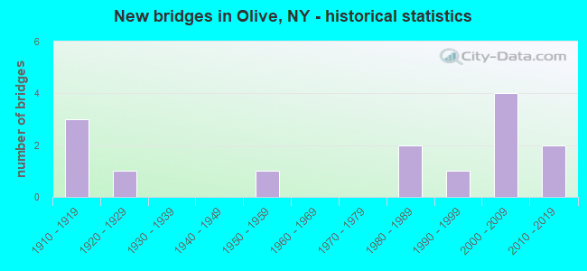
- New bridges - historical statistics
- 31910-1919
- 11920-1929
- 11950-1959
- 21980-1989
- 11990-1999
- 42000-2009
- 22010-2019

- Bridge Condition - Deck
- 9.1%Very good
- 18.2%Good
- 9.1%Satisfactory
- 27.3%Fair
- 27.3%Poor
- 9.1%Serious

- Bridge Condition - Superstructure
- 33.3%Very good
- 8.3%Good
- 8.3%Satisfactory
- 8.3%Fair
- 41.7%Poor

- Bridge Condition - Substructure
- 16.7%Very good
- 16.7%Good
- 33.3%Satisfactory
- 33.3%Fair

- Bridge Condition - Channel
- 16.7%Very good
- 33.3%Good
- 33.3%Satisfactory
- 16.7%Fair
Find on map >> Show street view
Structure Number: 202038, Location: JCT RTE 28&28A-ESOPUS CRK (Lat: 42.003908, Lng: -74.267789), Route carried "on" structure: Other road 28A, Year Built: 1911, Year Reconstructed: 1975, Status: Posted for load-capacity, Structure Length: 13.87m (45.51ft), Average Daily Traffic: 1,417 (year 2016), Truck Traffic: 5%, Average Future Daily Traffic: 1,984 (year 2036), Design Load: HS 20, Features Intersected: ESOPUS CREEK
Minimum Vertical Clearance: 30+ m (98+ ft), Kilometerpoint: 0.145, Lanes on structure: 2, Base Highway Network: Yes, Owner: Local Agency, Approaching Roadway Width: 9.1m (29.9ft), Material/Design: Concrete continuous, Design/Construction: Arch - Deck, Number Of Spans In Main Unit: 5, Number Of Approach Spans: 8, Length of Maximum Span: 20.7m (67.9ft), Curb-To-Curb Width: 6.8m (22.3ft), Out-to-Out Width: 8.5m (27.9ft)
Condition: Deck: Poor, Superstructure: Poor, Substructure: Fair, Channel: Fair, Operating Rating: 30.8 metric tons, Method Used To Determine Operating Rating: Load Factor (LF), Inventory Rating: 17.2 metric tons, Method Used To Determine Inventory Rating: Load Factor (LF), Structural Evaluation: Meets minimum limits, Deck Geometry: High priority of corrective action, Waterway Adequacy: Equal to present minimum criteria, Approach Roadway Alignment: Equal to present minimum criteria, Length Of Structure Improvement: 13.86m (45.47ft), Designated Inspection Frequency: Every 12 months, Inspection Date: December 2021, Bridge Improvement Cost: $9,497,000, Roadway Improvement Cost: $5,561,000, Total Project Cost: $15,058,000 ( Estimate for 2021), Deck Structure Type: Concrete Cast-file-Place, Wearing Surface/Protective System: Wearing Surface: Bituminous
Find on map >> Show street view
Structure Number: 202039, Location: .3 MI W JCT SH 28A & SH28 (Lat: 42.003381, Lng: -74.269989), Route carried "on" structure: Alternate State highway 28A, Year Built: 1911, Status: Open, Structure Length: 1.62m (5.31ft), Average Daily Traffic: 1,417 (year 2016), Truck Traffic: 5%, Average Future Daily Traffic: 1,984 (year 2036), Features Intersected: EX-ULSTER & DELWR
Minimum Vertical Clearance: 30+ m (98+ ft), Kilometerpoint: 0.402, Lanes on structure: 2, Base Highway Network: Yes, Owner: Local Agency, Approaching Roadway Width: 6.7m (22.0ft), Material/Design: Concrete, Design/Construction: Girder and Floorbeam System, Number Of Spans In Main Unit: 1, Length of Maximum Span: 12.5m (41.0ft), Curb-To-Curb Width: 6.8m (22.3ft), Out-to-Out Width: 8.7m (28.5ft)
Condition: Deck: Fair, Superstructure: Poor, Substructure: Fair, Operating Rating: 43.1 metric tons, Method Used To Determine Operating Rating: Field evaluation and documented engineering judgment, Inventory Rating: 18.6 metric tons, Method Used To Determine Inventory Rating: Field evaluation and documented engineering judgment, Structural Evaluation: Meets minimum limits, Deck Geometry: High priority of corrective action, Underclear: Somewhat better than minimum adequacy, Approach Roadway Alignment: Meets minimum limits, Length Of Structure Improvement: 1.61m (5.28ft), Designated Inspection Frequency: Every 24 months, Critical Feature Inspection Frequency: Every 24 months, Inspection Date: December 2020, Critical Feature Inspection Date: December 2020, Bridge Improvement Cost: $1,422,000, Roadway Improvement Cost: $833,000, Total Project Cost: $2,255,000 ( Estimate for 2021), Deck Structure Type: Concrete Cast-file-Place, Wearing Surface/Protective System: Wearing Surface: Bituminous
Find on map >> Show street view
Structure Number: 20204, Location: 1.2 MI SW JCT SH 28 & SH2 (Lat: 41.992167, Lng: -74.277700), Route carried "on" structure: State highway 28A, Year Built: 1981, Status: Open, Structure Length: 14.42m (47.31ft), Average Daily Traffic: 1,417 (year 2016), Truck Traffic: 5%, Average Future Daily Traffic: 1,984 (year 2036), Design Load: HS 20, Features Intersected: TRAVER HOLLOW CREEK
Minimum Vertical Clearance: 30+ m (98+ ft), Kilometerpoint: 1.979, Lanes on structure: 2, Base Highway Network: Yes, Owner: Local Agency, Approaching Roadway Width: 9.8m (32.2ft), Material/Design: Steel continuous, Design/Construction: Stringer/Multi-beam, Number Of Spans In Main Unit: 2, Length of Maximum Span: 79.2m (259.8ft), Curb-To-Curb Width: 10.2m (33.5ft), Out-to-Out Width: 11.2m (36.7ft)
Condition: Deck: Very good, Superstructure: Very good, Substructure: Good, Channel: Good, Operating Rating: 49.6 metric tons, Method Used To Determine Operating Rating: Load and Resistance Factor Rating (LRFR) rating reported by rating factor(RF) method using HL-93 loadings, Inventory Rating: 38.2 metric tons, Method Used To Determine Inventory Rating: Load and Resistance Factor Rating (LRFR) rating reported by rating factor(RF) method using HL-93 loadings, Structural Evaluation: Better than present minimum criteria, Deck Geometry: Somewhat better than minimum adequacy, Waterway Adequacy: Somewhat better than minimum adequacy, Approach Roadway Alignment: Equal to present desirable criteria, Length Of Structure Improvement: 14.41m (47.28ft), Designated Inspection Frequency: Every 24 months, Inspection Date: July 2020, Bridge Improvement Cost: $6,144,000, Roadway Improvement Cost: $3,598,000, Total Project Cost: $9,742,000 ( Estimate for 2021), Deck Structure Type: Concrete Cast-file-Place, Wearing Surface/Protective System: Wearing Surface: Integral Concrete, Deck Protection: Epoxy Coated Reinforcing
Find on map >> Show street view
Structure Number: 202041, Location: 2.8 MI S JCT SH 28 & SH 2 (Lat: 41.971328, Lng: -74.277122), Route carried "on" structure: Alternate Other road 28A, Year Built: 2009, Status: Open, Structure Length: 11.19m (36.71ft), Average Daily Traffic: 1,417 (year 2016), Truck Traffic: 5%, Average Future Daily Traffic: 1,984 (year 2036), Design Load: HS 25 or greater, Features Intersected: DRY BROOK, Bush Kill
Minimum Vertical Clearance: 30+ m (98+ ft), Kilometerpoint: 4.586, Lanes on structure: 2, Base Highway Network: Yes, Owner: Local Agency, Approaching Roadway Width: 10.1m (33.1ft), Material/Design: Prestressed concrete, Design/Construction: Box Beam or Girders - Multiple, Number Of Spans In Main Unit: 5, Length of Maximum Span: 22.3m (73.2ft), Curb-To-Curb Width: 10.1m (33.1ft), Out-to-Out Width: 11.3m (37.1ft)
Condition: Deck: Fair, Superstructure: Good, Substructure: Satisfactory, Channel: Satisfactory, Operating Rating: 59.0 metric tons, Method Used To Determine Operating Rating: Load Factor (LF), Inventory Rating: 35.4 metric tons, Method Used To Determine Inventory Rating: Load Factor (LF), Structural Evaluation: Equal to present minimum criteria, Deck Geometry: Somewhat better than minimum adequacy, Waterway Adequacy: Somewhat better than minimum adequacy, Approach Roadway Alignment: Equal to present desirable criteria, Length Of Structure Improvement: 11.18m (36.68ft), Designated Inspection Frequency: Every 24 months, Inspection Date: October 2021, Bridge Improvement Cost: $3,180,000, Roadway Improvement Cost: $1,862,000, Total Project Cost: $5,042,000 ( Estimate for 2021), Wearing Surface/Protective System: Wearing Surface: Integral Concrete
Find on map >> Show street view
Structure Number: 202043, Location: 1.0MI E JCT RTE 28A&213 (Lat: 41.944650, Lng: -74.204686), Route carried "on" structure: Alternate State highway 28A, Year Built: 2010, Status: Open, Structure Length: 1.19m (3.90ft), Average Daily Traffic: 1,551 (year 2016), Truck Traffic: 5%, Average Future Daily Traffic: 2,171 (year 2036), Design Load: HS 25 or greater, Features Intersected: ASHOKAN RESV OTLT
Minimum Vertical Clearance: 30+ m (98+ ft), Kilometerpoint: 15.881, Lanes on structure: 2, Base Highway Network: Yes, Owner: Local Agency, Approaching Roadway Width: 8.5m (27.9ft), Skew: 2 degrees, Material/Design: Concrete, Design/Construction: Arch - Deck, Number Of Spans In Main Unit: 1, Length of Maximum Span: 8.8m (28.9ft), Curb-To-Curb Width: 9.9m (32.5ft), Out-to-Out Width: 11.1m (36.4ft)
Condition: Superstructure: Very good, Substructure: Very good, Channel: Good, Inventory Rating: 85.3 metric tons, Method Used To Determine Inventory Rating: Load Factor (LF), Structural Evaluation: Equal to present desirable criteria, Deck Geometry: Somewhat better than minimum adequacy, Waterway Adequacy: Somewhat better than minimum adequacy, Approach Roadway Alignment: Meets minimum limits, Length Of Structure Improvement: 1.18m (3.87ft), Designated Inspection Frequency: Every 24 months, Inspection Date: October 2020, Bridge Improvement Cost: $1,001,000, Roadway Improvement Cost: $586,000, Total Project Cost: $1,587,000 ( Estimate for 2021), Wearing Surface/Protective System: Wearing Surface: Bituminous
Find on map >> Show street view
Structure Number: 222441, Location: 1.2 MI S OF SHOKAN (Lat: 41.951936, Lng: -74.208378), Route carried "on" structure: Other road , Year Built: 1914, Status: Posted for load, Structure Length: 35.45m (116.31ft), Average Daily Traffic: 1,600 (year 1978), Truck Traffic: 10%, Average Future Daily Traffic: 2,240 (year 1998), Features Intersected: ASHOKAN RESERVOIR, Facility Carried by Structure: RESERVOIR ROAD
Minimum Vertical Clearance: 30+ m (98+ ft), Kilometerpoint: 0.000, Lanes on structure: 2, Owner: Local Agency, Approaching Roadway Width: 7.3m (24.0ft), Material/Design: Concrete continuous, Design/Construction: Arch - Deck, Number Of Spans In Main Unit: 15, Number Of Approach Spans: 5, Length of Maximum Span: 22.5m (73.8ft), Curb-To-Curb Width: 7.3m (24.0ft), Out-to-Out Width: 9.5m (31.2ft)
Condition: Deck: Poor, Superstructure: Poor, Substructure: Fair, Channel: Very good, Operating Rating: 31.8 metric tons, Method Used To Determine Operating Rating: Allowable Stress (AS), Inventory Rating: 18.1 metric tons, Method Used To Determine Inventory Rating: Allowable Stress (AS), Structural Evaluation: Meets minimum limits, Deck Geometry: Meets minimum limits, Waterway Adequacy: Superior to present desirable criteria, Approach Roadway Alignment: Meets minimum limits, Bridge Posting: Required (Relationship of Operating Rating to Maximum Legal Load: > 39.9% below), Length Of Structure Improvement: 35.44m (116.27ft), Designated Inspection Frequency: Every 12 months, Inspection Date: November 2021, Bridge Improvement Cost: $25,109,000, Roadway Improvement Cost: $14,704,000, Total Project Cost: $39,813,000 ( Estimate for 2021), Wearing Surface/Protective System: Wearing Surface: Bituminous
Find on map >> Show street view
Structure Number: 222442, Location: AT SHOKAN (Lat: 41.969958, Lng: -74.210369), Route carried "on" structure: Other road , Year Built: 2009, Status: Open, Structure Length: 0.91m (2.99ft), Truck Traffic: 10%, Design Load: HS 20, Features Intersected: ASHOKAN RAIL TRAIL, Facility Carried by Structure: RESERVOIR RD
Minimum Vertical Clearance: 30+ m (98+ ft), Kilometerpoint: 0.064, Lanes on structure: 2, Owner: Local Agency, Approaching Roadway Width: 9.8m (32.2ft), Material/Design: Steel, Design/Construction: Culvert, Number Of Spans In Main Unit: 1, Length of Maximum Span: 8.8m (28.9ft)
Condition: Culverts: Very good, Operating Rating: 54.4 metric tons, Method Used To Determine Operating Rating: Load Factor (LF), Inventory Rating: 32.7 metric tons, Method Used To Determine Inventory Rating: Load Factor (LF), Structural Evaluation: Equal to present desirable criteria, Approach Roadway Alignment: Equal to present desirable criteria, Length Of Structure Improvement: 0.91m (2.99ft), Designated Inspection Frequency: Every 24 months, Inspection Date: October 2021, Bridge Improvement Cost: $251,000, Roadway Improvement Cost: $147,000, Total Project Cost: $399,000 ( Estimate for 2021)
Find on map >> Show street view
Structure Number: 227082, Location: 3.5 MI NW JCT Rts. 28 & 2 (Lat: 42.006089, Lng: -74.290400), Route carried "on" structure: Other road , Year Built: 2012, Status: Open, Structure Length: 0.79m (2.59ft), Average Daily Traffic: 7 (year 2018), Truck Traffic: 8%, Average Future Daily Traffic: 10 (year 2038), Design Load: HS 25 or greater, Features Intersected: Traver Hollow Creek, Facility Carried by Structure: BRADKIN ROAD
Minimum Vertical Clearance: 30+ m (98+ ft), Kilometerpoint: 0.306, Lanes on structure: 2, Owner: Town or Township Highway Agency, Approaching Roadway Width: 5.5m (18.0ft), Material/Design: Aluminum, Iron, Design/Construction: Culvert, Number Of Spans In Main Unit: 1, Length of Maximum Span: 7.6m (24.9ft)
Condition: Channel: Satisfactory, Culverts: Very good, Operating Rating: 78.0 metric tons, Method Used To Determine Operating Rating: Field evaluation and documented engineering judgment, Inventory Rating: 40.8 metric tons, Method Used To Determine Inventory Rating: Field evaluation and documented engineering judgment, Structural Evaluation: Equal to present desirable criteria, Waterway Adequacy: Meets minimum limits, Approach Roadway Alignment: Equal to present minimum criteria, Length Of Structure Improvement: 0.79m (2.59ft), Designated Inspection Frequency: Every 24 months, Inspection Date: June 2020, Bridge Improvement Cost: $123,000, Roadway Improvement Cost: $72,000, Total Project Cost: $194,000 ( Estimate for 2021), Wearing Surface/Protective System: Wearing Surface: Bituminous
Find on map >> Show street view
Structure Number: 304114, Location: 0.75 MI S JCT RTS 28A&213 (Lat: 41.921878, Lng: -74.214286), Route carried "on" structure: County highway 213, Year Built: 1929, Status: Posted for load, Structure Length: 1.68m (5.51ft), Average Daily Traffic: 1,114 (year 2017), Truck Traffic: 4%, Average Future Daily Traffic: 1,162 (year 2040), Features Intersected: TONGORE BROOK
Minimum Vertical Clearance: 30+ m (98+ ft), Kilometerpoint: 1.416, Lanes on structure: 2, Base Highway Network: Yes, Owner: County Highway Agency, Approaching Roadway Width: 6.1m (20.0ft), Material/Design: Concrete, Design/Construction: Arch - Deck, Number Of Spans In Main Unit: 1, Length of Maximum Span: 16.2m (53.1ft), Curb or Sidewalk Widths: Left: 0.3m (1.0ft), Right: 0.5m (1.6ft), Curb-To-Curb Width: 6.6m (21.7ft), Out-to-Out Width: 8.4m (27.6ft)
Condition: Deck: Fair, Superstructure: Satisfactory, Substructure: Satisfactory, Channel: Satisfactory, Operating Rating: 13.6 metric tons, Method Used To Determine Operating Rating: Field evaluation and documented engineering judgment, Inventory Rating: 13.6 metric tons, Method Used To Determine Inventory Rating: Field evaluation and documented engineering judgment, Structural Evaluation: Meets minimum limits, Deck Geometry: High priority of replacement, Waterway Adequacy: Meets minimum limits, Approach Roadway Alignment: Meets minimum limits, Bridge Posting: Required (Relationship of Operating Rating to Maximum Legal Load: > 39.9% below), Length Of Structure Improvement: 1.67m (5.48ft), Designated Inspection Frequency: Every 12 months, Inspection Date: August 2021, Bridge Improvement Cost: $655,000, Roadway Improvement Cost: $383,000, Total Project Cost: $1,038,000 ( Estimate for 2021), Deck Structure Type: Concrete Cast-file-Place, Wearing Surface/Protective System: Wearing Surface: Bituminous
Find on map >> Show street view
Structure Number: 334637, Location: IN WEST SHOKAN (Lat: 41.967097, Lng: -74.286989), Route carried "on" structure: County highway , Year Built: 1993, Status: Open, Structure Length: 6.34m (20.80ft), Average Daily Traffic: 1,016 (year 2020), Truck Traffic: 10%, Average Future Daily Traffic: 1,422 (year 2040), Design Load: HS 20, Features Intersected: BUSHKILL CREEK, Facility Carried by Structure: CR 42
Minimum Vertical Clearance: 30+ m (98+ ft), Kilometerpoint: 10.056, Lanes on structure: 2, Owner: County Highway Agency, Approaching Roadway Width: 8.5m (27.9ft), Skew: 1 degrees, Material/Design: Steel continuous, Design/Construction: Stringer/Multi-beam, Number Of Spans In Main Unit: 2, Length of Maximum Span: 31.0m (101.7ft), Curb-To-Curb Width: 8.5m (27.9ft), Out-to-Out Width: 9.1m (29.9ft)
Condition: Deck: Good, Superstructure: Very good, Substructure: Good, Channel: Good, Operating Rating: 62.6 metric tons, Method Used To Determine Operating Rating: Load Factor (LF), Inventory Rating: 45.4 metric tons, Method Used To Determine Inventory Rating: Load Factor (LF), Structural Evaluation: Better than present minimum criteria, Deck Geometry: Somewhat better than minimum adequacy, Waterway Adequacy: Superior to present desirable criteria, Approach Roadway Alignment: Somewhat better than minimum adequacy, Length Of Structure Improvement: 6.33m (20.77ft), Designated Inspection Frequency: Every 24 months, Inspection Date: October 2020, Bridge Improvement Cost: $2,402,000, Roadway Improvement Cost: $1,407,000, Total Project Cost: $3,809,000 ( Estimate for 2021), Deck Structure Type: Concrete Cast-file-Place, Wearing Surface/Protective System: Wearing Surface: Integral Concrete, Deck Protection: Epoxy Coated Reinforcing
Find on map >> Show street view
Structure Number: 334669, Location: 2.2 MI SW OF WEST SHOKAN (Lat: 41.949758, Lng: -74.318419), Route carried "on" structure: Other road , Year Built: 1983, Status: Posted for load, Structure Length: 1.34m (4.40ft), Average Daily Traffic: 7 (year 2019), Truck Traffic: 8%, Average Future Daily Traffic: 10 (year 2039), Features Intersected: BUSH KILL, Facility Carried by Structure: SOUTH HOLLOW ROAD
Minimum Vertical Clearance: 30+ m (98+ ft), Kilometerpoint: 0.000, Lanes on structure: 2, Owner: County Highway Agency, Approaching Roadway Width: 5.8m (19.0ft), Material/Design: Steel, Design/Construction: Stringer/Multi-beam, Number Of Spans In Main Unit: 1, Length of Maximum Span: 12.8m (42.0ft), Curb-To-Curb Width: 5.9m (19.4ft), Out-to-Out Width: 6.7m (22.0ft)
Condition: Deck: Satisfactory, Superstructure: Poor, Substructure: Fair, Channel: Fair, Operating Rating: 29.0 metric tons, Method Used To Determine Operating Rating: Load Factor (LF), Inventory Rating: 17.2 metric tons, Method Used To Determine Inventory Rating: Load Factor (LF), Structural Evaluation: Meets minimum limits, Deck Geometry: Meets minimum limits, Waterway Adequacy: Meets minimum limits, Approach Roadway Alignment: Meets minimum limits, Bridge Posting: Required (Relationship of Operating Rating to Maximum Legal Load: 30.0 - 39.9% below), Length Of Structure Improvement: 1.34m (4.40ft), Designated Inspection Frequency: Every 12 months, Inspection Date: June 2021, Bridge Improvement Cost: $786,000, Roadway Improvement Cost: $460,000, Total Project Cost: $1,246,000 ( Estimate for 2021), Deck Structure Type: Wood or Timber, Wearing Surface/Protective System: Wearing Surface: Bituminous
Find on map >> Show street view
Structure Number: 33468, Location: 2.0 MI SW OF KRUMVILLE (Lat: 41.866072, Lng: -74.266742), Route carried "on" structure: Other road , Year Built: 2008, Status: Open, Structure Length: 1.22m (4.00ft), Average Daily Traffic: 72 (year 2019), Truck Traffic: 4%, Average Future Daily Traffic: 101 (year 2039), Design Load: HS 25 or greater, Features Intersected: ROCHESTER CREEK, Facility Carried by Structure: UPPER SAHLER MILL
Minimum Vertical Clearance: 30+ m (98+ ft), Kilometerpoint: 2.751, Lanes on structure: 1, Owner: County Highway Agency, Approaching Roadway Width: 6.4m (21.0ft), Material/Design: Steel, Design/Construction: Stringer/Multi-beam, Number Of Spans In Main Unit: 1, Length of Maximum Span: 9.7m (31.8ft), Curb-To-Curb Width: 6.4m (21.0ft), Out-to-Out Width: 6.7m (22.0ft)
Condition: Deck: Good, Superstructure: Very good, Substructure: Very good, Channel: Satisfactory, Operating Rating: 48.0 metric tons, Method Used To Determine Operating Rating: Load and Resistance Factor Rating (LRFR) rating reported by rating factor(RF) method using HL-93 loadings, Inventory Rating: 37.3 metric tons, Method Used To Determine Inventory Rating: Load and Resistance Factor Rating (LRFR) rating reported by rating factor(RF) method using HL-93 loadings, Structural Evaluation: Equal to present desirable criteria, Deck Geometry: Somewhat better than minimum adequacy, Waterway Adequacy: Superior to present desirable criteria, Approach Roadway Alignment: Equal to present desirable criteria, Length Of Structure Improvement: 1.21m (3.97ft), Designated Inspection Frequency: Every 24 months, Inspection Date: December 2020, Bridge Improvement Cost: $423,000, Roadway Improvement Cost: $248,000, Total Project Cost: $670,000 ( Estimate for 2021), Deck Structure Type: Concrete Precast Panels, Wearing Surface/Protective System: Wearing Surface: Bituminous, Membrane: Other
Find on map >> Show street view
Structure Number: 334756, Location: 0.4 MI W OF WEST SHOKAN (Lat: 41.966294, Lng: -74.294742), Route carried "on" structure: County highway , Year Built: 1957, Status: Open, Structure Length: 2.01m (6.59ft), Average Daily Traffic: 1,016 (year 2020), Truck Traffic: 10%, Average Future Daily Traffic: 1,422 (year 2040), Design Load: H 20, Features Intersected: MALTBY HOLLOW BROOK, Facility Carried by Structure: COUNTY ROAD 42
Minimum Vertical Clearance: 30+ m (98+ ft), Kilometerpoint: 9.348, Lanes on structure: 2, Owner: County Highway Agency, Approaching Roadway Width: 7.9m (25.9ft), Skew: 2 degrees, Material/Design: Steel, Design/Construction: Stringer/Multi-beam, Number Of Spans In Main Unit: 1, Length of Maximum Span: 18.5m (60.7ft), Curb or Sidewalk Widths: Left: 0.5m (1.6ft), Right: 0.5m (1.6ft), Curb-To-Curb Width: 7.9m (25.9ft), Out-to-Out Width: 9.5m (31.2ft)
Condition: Deck: Serious, Superstructure: Fair, Substructure: Satisfactory, Channel: Very good, Operating Rating: 55.4 metric tons, Method Used To Determine Operating Rating: Load and Resistance Factor Rating (LRFR) rating reported by rating factor(RF) method using HL-93 loadings, Inventory Rating: 42.8 metric tons, Method Used To Determine Inventory Rating: Load and Resistance Factor Rating (LRFR) rating reported by rating factor(RF) method using HL-93 loadings, Structural Evaluation: Somewhat better than minimum adequacy, Deck Geometry: Meets minimum limits, Waterway Adequacy: Meets minimum limits, Approach Roadway Alignment: Equal to present minimum criteria, Length Of Structure Improvement: 2.01m (6.59ft), Designated Inspection Frequency: Every 24 months, Inspection Date: July 2021, Bridge Improvement Cost: $1,254,000, Roadway Improvement Cost: $734,000, Total Project Cost: $1,988,000 ( Estimate for 2021), Deck Structure Type: Concrete Cast-file-Place, Wearing Surface/Protective System: Wearing Surface: Bituminous
Find on map >> Show street view
Structure Number: 33477, Location: AT SAMSONVILLE (Lat: 41.886739, Lng: -74.296147), Route carried "on" structure: County highway , Year Built: 2000, Status: Open, Structure Length: 1.58m (5.18ft), Average Daily Traffic: 788 (year 2018), Truck Traffic: 10%, Average Future Daily Traffic: 1,103 (year 2038), Design Load: HS 25 or greater, Features Intersected: METTACAHONTS CRK, Facility Carried by Structure: SAMSONVILLE ROAD
Minimum Vertical Clearance: 30+ m (98+ ft), Kilometerpoint: 0.515, Lanes on structure: 2, Owner: County Highway Agency, Approaching Roadway Width: 8.5m (27.9ft), Skew: 1 degrees, Material/Design: Steel, Design/Construction: Stringer/Multi-beam, Number Of Spans In Main Unit: 1, Length of Maximum Span: 15.5m (50.9ft), Curb-To-Curb Width: 8.6m (28.2ft), Out-to-Out Width: 8.8m (28.9ft)
Condition: Deck: Poor, Superstructure: Poor, Substructure: Satisfactory, Channel: Good, Operating Rating: 63.5 metric tons, Method Used To Determine Operating Rating: Load Factor (LF), Inventory Rating: 37.2 metric tons, Method Used To Determine Inventory Rating: Load Factor (LF), Structural Evaluation: Meets minimum limits, Deck Geometry: Somewhat better than minimum adequacy, Waterway Adequacy: Superior to present desirable criteria, Approach Roadway Alignment: Equal to present minimum criteria, Length Of Structure Improvement: 1.58m (5.18ft), Designated Inspection Frequency: Every 24 months, Inspection Date: August 2020, Bridge Improvement Cost: $891,000, Roadway Improvement Cost: $522,000, Total Project Cost: $1,413,000 ( Estimate for 2021), Deck Structure Type: Corrugated Steel, Wearing Surface/Protective System: Wearing Surface: Bituminous, Membrane: Other