Bridge Statistics for Olympian Village, Missouri (MO)
Condition, Traffic, Stress, Structural Evaluation, Project Costs
- National Bridge Inventory (NBI) Statistics
- 16Number of bridges
- 85ft / 26.1mTotal length
- $215,000Total costs
- 83,124Total average daily traffic
- 7,510Total average daily truck traffic
- National Bridge Inventory (NBI) Registered Bridges for Olympian Village
- No street view available for this location
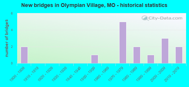
- New bridges - historical statistics
- 21900-1909
- 11950-1959
- 51970-1979
- 21980-1989
- 11990-1999
- 32000-2009
- 22010-2019

- Reconstructed bridges - Historical Statistics
- 21970-1979
- 01980-1989
- 11990-1999
- 32000-2009


- Bridge Condition - Deck
- 10.0%Very good
- 40.0%Good
- 40.0%Satisfactory
- 10.0%Fair

- Bridge Condition - Superstructure
- 30.0%Very good
- 10.0%Good
- 40.0%Satisfactory
- 10.0%Fair
- 10.0%Poor

- Bridge Condition - Substructure
- 20.0%Very good
- 50.0%Good
- 10.0%Satisfactory
- 20.0%Fair

- Bridge Condition - Channel
- 42.9%Good
- 42.9%Satisfactory
- 7.1%Fair
- 7.1%Poor
Find on map >> Show street view
Structure Number: 16974, Location: S 4 T 39 N R 5 E (Lat: 38.127242, Lng: -90.482367), Route carried "on" structure: County highway 333, Year Built: 1976, Status: Posted for load, Structure Length: 0.94m (3.08ft), Average Daily Traffic: 347 (year 2021), Truck Traffic: 10%, Average Future Daily Traffic: 694 (year 2041), Features Intersected: TRIB OF JOACHIM CR, Facility Carried by Structure: ARMBRUSTER RD
Minimum Vertical Clearance: 30+ m (98+ ft), Kilometerpoint: 2.092, Lanes on structure: 2, Owner: County Highway Agency, Approaching Roadway Width: 8.8m (28.9ft), Material/Design: Steel, Design/Construction: Stringer/Multi-beam, Number Of Spans In Main Unit: 1, Length of Maximum Span: 8.8m (28.9ft), Curb-To-Curb Width: 7.8m (25.6ft), Out-to-Out Width: 8.4m (27.6ft)
Condition: Deck: Good, Superstructure: Poor, Substructure: Good, Channel: Good, Operating Rating: 18.9 metric tons, Method Used To Determine Operating Rating: Load Factor (LF), Inventory Rating: 11.7 metric tons, Method Used To Determine Inventory Rating: Load Factor (LF), Structural Evaluation: Meets minimum limits, Deck Geometry: Somewhat better than minimum adequacy, Waterway Adequacy: Equal to present desirable criteria, Approach Roadway Alignment: Equal to present desirable criteria, Bridge Posting: Required (Relationship of Operating Rating to Maximum Legal Load: > 39.9% below), Length Of Structure Improvement: 0.16m (0.52ft), Designated Inspection Frequency: Every 24 months, Inspection Date: January 2021, Bridge Improvement Cost: $143,000, Roadway Improvement Cost: $14,000, Total Project Cost: $215,000 ( Estimate for 2022), Deck Structure Type: Concrete Cast-file-Place, Wearing Surface/Protective System: Wearing Surface: Bituminous
Find on map >> Show street view
Structure Number: 19491, Location: S 26 T 40 N R 5 E (Lat: 38.163603, Lng: -90.456100), Route carried "on" structure: County highway 222, Year Built: 1992, Status: Open, Structure Length: 0.73m (2.40ft), Average Daily Traffic: 2,079 (year 2021), Truck Traffic: 10%, Average Future Daily Traffic: 3,534 (year 2041), Features Intersected: BUCK CR, Facility Carried by Structure: VICTORIA RD
Minimum Vertical Clearance: 30+ m (98+ ft), Kilometerpoint: 2.414, Lanes on structure: 2, Owner: County Highway Agency, Approaching Roadway Width: 7.3m (24.0ft), Material/Design: Concrete, Design/Construction: Frame, Number Of Spans In Main Unit: 1, Length of Maximum Span: 7.3m (24.0ft), Curb-To-Curb Width: 8.5m (27.9ft), Out-to-Out Width: 9.2m (30.2ft)
Condition: Deck: Satisfactory, Superstructure: Satisfactory, Substructure: Good, Channel: Good, Operating Rating: 54.0 metric tons, Method Used To Determine Operating Rating: Allowable Stress (AS), Inventory Rating: 32.4 metric tons, Method Used To Determine Inventory Rating: Allowable Stress (AS), Structural Evaluation: Equal to present minimum criteria, Deck Geometry: Meets minimum limits, Waterway Adequacy: Equal to present desirable criteria, Approach Roadway Alignment: Equal to present desirable criteria, Designated Inspection Frequency: Every 24 months, Inspection Date: January 2021, Deck Structure Type: Concrete Precast Panels, Wearing Surface/Protective System: Wearing Surface: Bituminous, Deck Protection: Epoxy Coated Reinforcing
Find on map >> Show street view
Structure Number: 21809, Location: S 14 T 39 N R 5 E (Lat: 38.101469, Lng: -90.443603), Route carried "on" structure: County highway 345, Year Built: 1984, Year Reconstructed: 2009, Status: Open, Structure Length: 1.52m (4.99ft), Average Daily Traffic: 200 (year 2021), Truck Traffic: 10%, Average Future Daily Traffic: 400 (year 2041), Design Load: HS 20, Features Intersected: FLUCOM CR, Facility Carried by Structure: FLUCOM EAST RD
Minimum Vertical Clearance: 30+ m (98+ ft), Kilometerpoint: 3.541, Lanes on structure: 2, Owner: County Highway Agency, Approaching Roadway Width: 7.3m (24.0ft), Skew: 3 degrees, Material/Design: Prestressed concrete, Design/Construction: Box Beam or Girders - Multiple, Number Of Spans In Main Unit: 1, Length of Maximum Span: 14.9m (48.9ft), Curb-To-Curb Width: 8.5m (27.9ft), Out-to-Out Width: 8.7m (28.5ft)
Condition: Deck: Satisfactory, Superstructure: Satisfactory, Substructure: Fair, Channel: Satisfactory, Operating Rating: 60.3 metric tons, Method Used To Determine Operating Rating: Load Factor (LF), Inventory Rating: 36.0 metric tons, Method Used To Determine Inventory Rating: Load Factor (LF), Structural Evaluation: Somewhat better than minimum adequacy, Deck Geometry: Equal to present minimum criteria, Waterway Adequacy: Equal to present desirable criteria, Approach Roadway Alignment: Equal to present desirable criteria, Designated Inspection Frequency: Every 24 months, Inspection Date: January 2021, Deck Structure Type: Other, Wearing Surface/Protective System: Wearing Surface: Bituminous, Membrane: Preformed Fabric, Deck Protection: Other
Find on map >> Show street view
Structure Number: 22086, Location: S 857 T 39 N R 6 E (Lat: 38.131072, Lng: -90.410878), Route carried "on" structure: County highway 340, Year Built: 2000, Status: Open, Structure Length: 3.14m (10.30ft), Average Daily Traffic: 300 (year 2021), Truck Traffic: 10%, Average Future Daily Traffic: 600 (year 2041), Design Load: HS 20, Features Intersected: TRIB OF PLATTIN CR, Facility Carried by Structure: HARNESS RD
Minimum Vertical Clearance: 30+ m (98+ ft), Kilometerpoint: 0.161, Lanes on structure: 2, Owner: County Highway Agency, Approaching Roadway Width: 10.4m (34.1ft), Skew: 3 degrees, Material/Design: Prestressed concrete, Design/Construction: Stringer/Multi-beam, Number Of Spans In Main Unit: 1, Length of Maximum Span: 30.5m (100.1ft), Curb-To-Curb Width: 10.4m (34.1ft), Out-to-Out Width: 11.2m (36.7ft)
Condition: Deck: Good, Superstructure: Very good, Substructure: Very good, Channel: Good, Operating Rating: 79.2 metric tons, Method Used To Determine Operating Rating: Load Factor (LF), Inventory Rating: 33.3 metric tons, Method Used To Determine Inventory Rating: Load Factor (LF), Structural Evaluation: Equal to present desirable criteria, Deck Geometry: Better than present minimum criteria, Waterway Adequacy: Equal to present desirable criteria, Approach Roadway Alignment: Equal to present desirable criteria, Designated Inspection Frequency: Every 24 months, Inspection Date: January 2021, Deck Structure Type: Concrete Cast-file-Place, Wearing Surface/Protective System: Wearing Surface: Monolithic Concrete, Deck Protection: Epoxy Coated Reinforcing
Find on map >> Show street view
Structure Number: 22089, Location: S 857 T 39 N R 6 E (Lat: 38.128942, Lng: -90.409211), Route carried "on" structure: County highway 340, Year Built: 1906, Year Reconstructed: 1984, Status: Open, Structure Length: 4.51m (14.80ft), Average Daily Traffic: 300 (year 2021), Truck Traffic: 10%, Average Future Daily Traffic: 600 (year 2041), Design Load: H 15, Features Intersected: PLATTIN CR, Facility Carried by Structure: HARNESS RD
Minimum Vertical Clearance: 30+ m (98+ ft), Kilometerpoint: 0.402, Lanes on structure: 2, Owner: County Highway Agency, Approaching Roadway Width: 8.5m (27.9ft), Material/Design: Prestressed concrete, Design/Construction: Box Beam or Girders - Multiple, Number Of Spans In Main Unit: 2, Length of Maximum Span: 22.3m (73.2ft), Curb-To-Curb Width: 8.4m (27.6ft), Out-to-Out Width: 8.6m (28.2ft)
Condition: Deck: Fair, Superstructure: Fair, Substructure: Fair, Channel: Poor, Operating Rating: 30.6 metric tons, Method Used To Determine Operating Rating: Allowable Stress (AS), Inventory Rating: 13.5 metric tons, Method Used To Determine Inventory Rating: Allowable Stress (AS), Structural Evaluation: Meets minimum limits, Deck Geometry: Somewhat better than minimum adequacy, Waterway Adequacy: Equal to present desirable criteria, Approach Roadway Alignment: Equal to present minimum criteria, Designated Inspection Frequency: Every 24 months, Underwater Inspection Frequency: Every 60 months, Inspection Date: January 2021, Underwater Inspection Date: June 2020, Deck Structure Type: Concrete Precast Panels, Wearing Surface/Protective System: Wearing Surface: Bituminous
Find on map >> Show street view
Structure Number: 22151, Location: S 13 T 39 N R 5 E (Lat: 38.094156, Lng: -90.420542), Route carried "on" structure: County highway 342, Year Built: 1984, Year Reconstructed: 2009, Status: Open, Structure Length: 1.21m (3.97ft), Average Daily Traffic: 109 (year 2021), Truck Traffic: 5%, Average Future Daily Traffic: 218 (year 2041), Design Load: HS 20, Features Intersected: TRIB OF FLUCOM BR, Facility Carried by Structure: CHARTER CHURCH RD
Minimum Vertical Clearance: 30+ m (98+ ft), Kilometerpoint: 4.104, Lanes on structure: 2, Owner: County Highway Agency, Approaching Roadway Width: 7.3m (24.0ft), Skew: 2 degrees, Material/Design: Prestressed concrete, Design/Construction: Box Beam or Girders - Multiple, Number Of Spans In Main Unit: 1, Length of Maximum Span: 11.7m (38.4ft), Curb-To-Curb Width: 8.5m (27.9ft), Out-to-Out Width: 8.5m (27.9ft)
Condition: Deck: Satisfactory, Superstructure: Satisfactory, Substructure: Satisfactory, Channel: Satisfactory, Operating Rating: 55.8 metric tons, Method Used To Determine Operating Rating: Load Factor (LF), Inventory Rating: 33.3 metric tons, Method Used To Determine Inventory Rating: Load Factor (LF), Structural Evaluation: Equal to present minimum criteria, Deck Geometry: Equal to present minimum criteria, Waterway Adequacy: Better than present minimum criteria, Approach Roadway Alignment: Meets minimum limits, Designated Inspection Frequency: Every 24 months, Inspection Date: January 2021, Deck Structure Type: Concrete Precast Panels, Wearing Surface/Protective System: Wearing Surface: Bituminous, Membrane: Preformed Fabric, Deck Protection: Other
Find on map >> Show street view
Structure Number: 22154, Location: S 13 T 39 N R 5 E (Lat: 38.091019, Lng: -90.425317), Route carried "on" structure: County highway 345, Year Built: 1900, Year Reconstructed: 2009, Status: Open, Structure Length: 0.82m (2.69ft), Average Daily Traffic: 109 (year 2021), Truck Traffic: 5%, Average Future Daily Traffic: 218 (year 2041), Design Load: HS 20, Features Intersected: TRIB OF PLATTIN CR, Facility Carried by Structure: CHARTER CHURCH RD
Minimum Vertical Clearance: 30+ m (98+ ft), Kilometerpoint: 4.983, Lanes on structure: 2, Owner: County Highway Agency, Approaching Roadway Width: 9.1m (29.9ft), Material/Design: Concrete continuous, Design/Construction: Culvert, Number Of Spans In Main Unit: 2, Length of Maximum Span: 3.7m (12.1ft), Curb-To-Curb Width: 9.1m (29.9ft), Out-to-Out Width: 9.8m (32.2ft)
Condition: Channel: Good, Culverts: Satisfactory, Operating Rating: 77.4 metric tons, Method Used To Determine Operating Rating: Load Factor (LF), Inventory Rating: 45.9 metric tons, Method Used To Determine Inventory Rating: Load Factor (LF), Structural Evaluation: Equal to present minimum criteria, Deck Geometry: Equal to present minimum criteria, Waterway Adequacy: Better than present minimum criteria, Approach Roadway Alignment: Equal to present minimum criteria, Designated Inspection Frequency: Every 24 months, Inspection Date: January 2021, Deck Structure Type: Concrete Cast-file-Place, Wearing Surface/Protective System: Wearing Surface: Monolithic Concrete
Find on map >> Show street view
Structure Number: 287, Location: S 5 T 39 N R 5 E (Lat: 38.138800, Lng: -90.487969), Route carried "on" structure: State highway 110, Year Built: 1976, Year Reconstructed: 1990, Status: Open, Structure Length: 1.15m (3.77ft), Average Daily Traffic: 12,086 (year 2021), Truck Traffic: 7%, Average Future Daily Traffic: 22,359 (year 2041), Design Load: HS 20, Features Intersected: E HAVERSTICK BR
Minimum Vertical Clearance: 30+ m (98+ ft), Kilometerpoint: 8.586, Lanes on structure: 2, Base Highway Network: Yes, Owner: State Highway Agency, Approaching Roadway Width: 13.4m (44.0ft), Material/Design: Concrete continuous, Design/Construction: Culvert, Number Of Spans In Main Unit: 3, Length of Maximum Span: 3.7m (12.1ft)
Condition: Channel: Fair, Culverts: Satisfactory, Inventory Rating: 77.4 metric tons, Method Used To Determine Inventory Rating: Load Factor (LF), Structural Evaluation: Equal to present minimum criteria, Waterway Adequacy: Equal to present desirable criteria, Approach Roadway Alignment: Equal to present desirable criteria, Designated Inspection Frequency: Every 24 months, Inspection Date: December 2020
Find on map >> Show street view
Structure Number: 2991, Location: S 5 T 39 N R 5 E (Lat: 38.138681, Lng: -90.490739), Route carried "on" structure: State highway 110, Year Built: 1976, Status: Open, Structure Length: 0.77m (2.53ft), Average Daily Traffic: 12,086 (year 2021), Truck Traffic: 7%, Average Future Daily Traffic: 22,359 (year 2041), Design Load: HS 20, Features Intersected: W HAVERSTICK BR
Minimum Vertical Clearance: 30+ m (98+ ft), Kilometerpoint: 8.344, Lanes on structure: 2, Base Highway Network: Yes, Owner: State Highway Agency, Approaching Roadway Width: 13.4m (44.0ft), Skew: 3 degrees, Material/Design: Concrete continuous, Design/Construction: Culvert, Number Of Spans In Main Unit: 2, Length of Maximum Span: 3.0m (9.8ft)
Condition: Channel: Satisfactory, Culverts: Satisfactory, Operating Rating: 87.3 metric tons, Method Used To Determine Operating Rating: Field evaluation and documented engineering judgment, Inventory Rating: 52.2 metric tons, Method Used To Determine Inventory Rating: Field evaluation and documented engineering judgment, Structural Evaluation: Equal to present minimum criteria, Waterway Adequacy: Equal to present desirable criteria, Approach Roadway Alignment: Equal to present desirable criteria, Designated Inspection Frequency: Every 24 months, Inspection Date: December 2020
Find on map >> Show street view
Structure Number: 31844, Location: S 11 T 39 N R 5 E (Lat: 38.116278, Lng: -90.442622), Route carried "on" structure: County highway 346, Year Built: 2006, Status: Open, Structure Length: 1.25m (4.10ft), Average Daily Traffic: 830 (year 2021), Truck Traffic: 10%, Average Future Daily Traffic: 1,660 (year 2041), Design Load: HS 20, Features Intersected: TRIB TO FLUCOM CR, Facility Carried by Structure: LEE PYLE RD
Minimum Vertical Clearance: 30+ m (98+ ft), Kilometerpoint: 0.805, Lanes on structure: 2, Owner: County Highway Agency, Approaching Roadway Width: 8.2m (26.9ft), Skew: 3 degrees, Material/Design: Prestressed concrete, Design/Construction: Box Beam or Girders - Multiple, Number Of Spans In Main Unit: 1, Length of Maximum Span: 12.0m (39.4ft), Curb-To-Curb Width: 8.5m (27.9ft), Out-to-Out Width: 8.5m (27.9ft)
Condition: Deck: Satisfactory, Superstructure: Satisfactory, Substructure: Good, Channel: Good, Operating Rating: 63.9 metric tons, Method Used To Determine Operating Rating: Load Factor (LF), Inventory Rating: 37.8 metric tons, Method Used To Determine Inventory Rating: Load Factor (LF), Structural Evaluation: Equal to present minimum criteria, Deck Geometry: Somewhat better than minimum adequacy, Waterway Adequacy: Equal to present desirable criteria, Approach Roadway Alignment: Meets minimum limits, Designated Inspection Frequency: Every 24 months, Inspection Date: January 2021, Wearing Surface/Protective System: Wearing Surface: Bituminous
Find on map >> Show street view
Structure Number: 31845, Location: S 6 T 39 N R 6 E (Lat: 38.141381, Lng: -90.407306), Route carried "on" structure: County highway 340, Year Built: 2007, Status: Open, Structure Length: 2.01m (6.59ft), Average Daily Traffic: 500 (year 2021), Truck Traffic: 5%, Average Future Daily Traffic: 1,000 (year 2041), Design Load: HS 20, Features Intersected: TRIB TO PLATTIN CR, Facility Carried by Structure: PLATTIN RD
Minimum Vertical Clearance: 30+ m (98+ ft), Kilometerpoint: 0.805, Lanes on structure: 2, Owner: County Highway Agency, Approaching Roadway Width: 9.1m (29.9ft), Skew: 2 degrees, Material/Design: Prestressed concrete, Design/Construction: Box Beam or Girders - Multiple, Number Of Spans In Main Unit: 1, Length of Maximum Span: 19.2m (63.0ft), Curb-To-Curb Width: 9.1m (29.9ft), Out-to-Out Width: 9.1m (29.9ft)
Condition: Deck: Very good, Superstructure: Very good, Substructure: Good, Channel: Satisfactory, Operating Rating: 63.9 metric tons, Method Used To Determine Operating Rating: Load Factor (LF), Inventory Rating: 38.7 metric tons, Method Used To Determine Inventory Rating: Load Factor (LF), Structural Evaluation: Better than present minimum criteria, Deck Geometry: Equal to present minimum criteria, Waterway Adequacy: Superior to present desirable criteria, Approach Roadway Alignment: Equal to present minimum criteria, Designated Inspection Frequency: Every 24 months, Inspection Date: January 2021, Wearing Surface/Protective System: Wearing Surface: Bituminous, Deck Protection: Other
Find on map >> Show street view
Structure Number: 34241, Location: S 5 T 39 N R 5 E (Lat: 38.140389, Lng: -90.486628), Route carried "on" structure: County highway , Year Built: 2014, Status: Open, Structure Length: 2.33m (7.64ft), Average Daily Traffic: 194 (year 2021), Truck Traffic: 5%, Average Future Daily Traffic: 388 (year 2041), Design Load: HS 20, Features Intersected: TRIB OF JOACHIM CR, Facility Carried by Structure: FOUNTAIN CITY RD
Minimum Vertical Clearance: 30+ m (98+ ft), Kilometerpoint: 0.000, Lanes on structure: 2, Owner: County Highway Agency, Approaching Roadway Width: 11.0m (36.1ft), Skew: 2 degrees, Material/Design: Prestressed concrete, Design/Construction: Stringer/Multi-beam, Number Of Spans In Main Unit: 1, Length of Maximum Span: 22.1m (72.5ft), Curb-To-Curb Width: 11.7m (38.4ft), Out-to-Out Width: 12.6m (41.3ft)
Condition: Deck: Good, Superstructure: Good, Substructure: Good, Channel: Good, Operating Rating: 77.4 metric tons, Method Used To Determine Operating Rating: Load Factor (LF), Inventory Rating: 37.8 metric tons, Method Used To Determine Inventory Rating: Load Factor (LF), Structural Evaluation: Better than present minimum criteria, Deck Geometry: Superior to present desirable criteria, Waterway Adequacy: Superior to present desirable criteria, Approach Roadway Alignment: Equal to present minimum criteria, Designated Inspection Frequency: Every 24 months, Inspection Date: January 2021, Deck Structure Type: Concrete Precast Panels
Find on map >> Show street view
Structure Number: 35717, Location: S 12 T 39 N R 5 E (Lat: 38.103800, Lng: -90.413631), Route carried "on" structure: County highway 342, Year Built: 2018, Status: Open, Structure Length: 4.70m (15.42ft), Average Daily Traffic: 277 (year 2021), Truck Traffic: 7%, Average Future Daily Traffic: 554 (year 2041), Features Intersected: PLATTIN CR, Facility Carried by Structure: CHARTER CHURCH RD
Minimum Vertical Clearance: 30+ m (98+ ft), Kilometerpoint: 0.161, Lanes on structure: 2, Owner: County Highway Agency, Approaching Roadway Width: 9.1m (29.9ft), Material/Design: Prestressed concrete continuous, Design/Construction: Stringer/Multi-beam, Number Of Spans In Main Unit: 2, Length of Maximum Span: 23.5m (77.1ft), Curb-To-Curb Width: 9.1m (29.9ft), Out-to-Out Width: 10.0m (32.8ft)
Condition: Deck: Good, Superstructure: Very good, Substructure: Very good, Channel: Satisfactory, Operating Rating: 69.3 metric tons, Method Used To Determine Operating Rating: Load Factor (LF), Inventory Rating: 54.0 metric tons, Method Used To Determine Inventory Rating: Load Factor (LF), Structural Evaluation: Equal to present desirable criteria, Deck Geometry: Equal to present minimum criteria, Waterway Adequacy: Superior to present desirable criteria, Approach Roadway Alignment: Equal to present minimum criteria, Designated Inspection Frequency: Every 24 months, Inspection Date: January 2021, Deck Structure Type: Concrete Cast-file-Place, Wearing Surface/Protective System: Wearing Surface: Monolithic Concrete, Deck Protection: Epoxy Coated Reinforcing
Find on map >> Show street view
Structure Number: 6361, Location: S 21 T 39 N R 5 E (Lat: 38.082772, Lng: -90.485136), Route carried "on" structure: US 67, Year Built: 1954, Year Reconstructed: 1970, Status: Open, Structure Length: 0.97m (3.18ft), Average Daily Traffic: 25,037 (year 2021), Truck Traffic: 10%, Average Future Daily Traffic: 46,318 (year 2041), Design Load: HS 20, Features Intersected: MCMULLEN BR
Minimum Vertical Clearance: 30+ m (98+ ft), Kilometerpoint: 115.382, Lanes on structure: 4, Base Highway Network: Yes, Owner: State Highway Agency, Approaching Roadway Width: 13.4m (44.0ft), Skew: 20 degrees, Material/Design: Concrete continuous, Design/Construction: Culvert, Number Of Spans In Main Unit: 3, Length of Maximum Span: 3.0m (9.8ft)
Condition: Channel: Satisfactory, Culverts: Satisfactory, Inventory Rating: 67.5 metric tons, Method Used To Determine Inventory Rating: Load Factor (LF), Structural Evaluation: Equal to present minimum criteria, Waterway Adequacy: Equal to present desirable criteria, Approach Roadway Alignment: Equal to present desirable criteria, Designated Inspection Frequency: Every 24 months, Inspection Date: December 2020
Find on map >> Show street view
Structure Number: 2242, Location: S 4 T 39 N R 5 E (Lat: 38.135906, Lng: -90.471475), Route carried "under" structure: US 67, Year Built: 1975, Structure Length: 0. m, Average Daily Traffic: 15,268 (year 2021), Truck Traffic: 9%, Features Intersected: US 67, Facility Carried by Structure: MO 110 E
Minimum Vertical Clearance: 5.21m (17.09ft), Kilometerpoint: 109.247, Lanes on structure: 2, Lanes under structure: 2, Material/Design: Steel continuous, Design/Construction: Stringer/Multi-beam, Length of Maximum Span: 19.8m (65.0ft)
Find on map >> Show street view
Structure Number: 2242, Location: S 4 T 39 N R 5 E (Lat: 38.135906, Lng: -90.471475), Route carried "under" structure: US 67, Year Built: 1975, Structure Length: 0. m, Average Daily Traffic: 13,402 (year 2021), Truck Traffic: 11%, Features Intersected: US 67, Facility Carried by Structure: MO 110 E
Minimum Vertical Clearance: 5.33m (17.49ft), Kilometerpoint: 208.896, Lanes on structure: 2, Lanes under structure: 2, Material/Design: Steel continuous, Design/Construction: Stringer/Multi-beam, Length of Maximum Span: 19.8m (65.0ft)