Bridge Statistics for Onalaska, Washington (WA)
Condition, Traffic, Stress, Structural Evaluation, Project Costs
- National Bridge Inventory (NBI) Statistics
- 12Number of bridges
- 102ft / 31.2mTotal length
- $14,407,000Total costs
- 21,773Total average daily traffic
- 2,884Total average daily truck traffic
- 30,980Total future (year 2037) average daily traffic
- National Bridge Inventory (NBI) Registered Bridges for Onalaska
- No street view available for this location
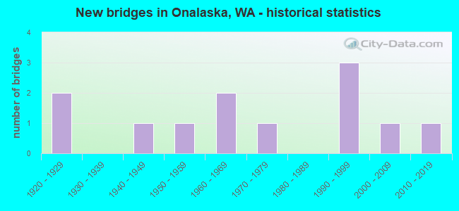
- New bridges - historical statistics
- 21920-1929
- 11940-1949
- 11950-1959
- 21960-1969
- 11970-1979
- 31990-1999
- 12000-2009
- 12010-2019

- Reconstructed bridges - Historical Statistics
- 11960-1969
- 01970-1979
- 01980-1989
- 01990-1999
- 12000-2009


- Bridge Condition - Deck
- 36.4%Very good
- 63.6%Good

- Bridge Condition - Superstructure
- 36.4%Very good
- 54.5%Good
- 9.1%Fair

- Bridge Condition - Substructure
- 36.4%Very good
- 36.4%Good
- 18.2%Satisfactory
- 9.1%Fair

- Bridge Condition - Channel
- 58.3%Very good
- 25.0%Good
- 16.7%Satisfactory
Find on map >> Show street view
Structure Number: 446A, Location: 6.7 E JCT I-5 (Lat: 46.532194, Lng: -122.739889), Route carried "on" structure: US 12, Year Built: 1921, Year Reconstructed: 2000, Status: Open, Structure Length: 0.82m (2.69ft), Average Daily Traffic: 8,805 (year 2019), Truck Traffic: 16%, Average Future Daily Traffic: 11,340 (year 2039), Features Intersected: LACAMAS CREEK
Minimum Vertical Clearance: 30+ m (98+ ft), Kilometerpoint: 117.852, Lanes on structure: 3, Base Highway Network: Yes, Owner: State Highway Agency, Approaching Roadway Width: 16.5m (54.1ft), Material/Design: Concrete continuous, Design/Construction: Slab, Number Of Spans In Main Unit: 2, Length of Maximum Span: 3.7m (12.1ft), Curb-To-Curb Width: 15.8m (51.8ft), Out-to-Out Width: 16.6m (54.5ft)
Condition: Deck: Good, Superstructure: Good, Substructure: Good, Channel: Satisfactory, Operating Rating: 25.6 metric tons, Method Used To Determine Operating Rating: Load and Resistance Factor Rating (LRFR) rating reported by rating factor(RF) method using HL-93 loadings, Inventory Rating: 19.8 metric tons, Method Used To Determine Inventory Rating: Load and Resistance Factor Rating (LRFR) rating reported by rating factor(RF) method using HL-93 loadings, Structural Evaluation: Somewhat better than minimum adequacy, Deck Geometry: Better than present minimum criteria, Waterway Adequacy: Equal to present minimum criteria, Approach Roadway Alignment: Equal to present desirable criteria, Length Of Structure Improvement: 0.82m (2.69ft), Designated Inspection Frequency: Every 24 months, Inspection Date: March 2021, Bridge Improvement Cost: $302,000, Roadway Improvement Cost: $60,000, Total Project Cost: $605,000 ( Estimate for 2014), Deck Structure Type: Concrete Cast-file-Place, Wearing Surface/Protective System: Wearing Surface: Bituminous, Membrane: Preformed Fabric
Find on map >> Show street view
Structure Number: 3344A, Location: 7.5 E JCT I-5 (Lat: 46.571642, Lng: -122.735056), Route carried "on" structure: State highway 508, Year Built: 1947, Status: Open, Structure Length: 1.13m (3.71ft), Average Daily Traffic: 4,595 (year 2019), Truck Traffic: 6%, Average Future Daily Traffic: 5,918 (year 2039), Design Load: HS 15, Features Intersected: GHEER CREEK
Minimum Vertical Clearance: 30+ m (98+ ft), Kilometerpoint: 12.183, Lanes on structure: 2, Owner: State Highway Agency, Approaching Roadway Width: 9.1m (29.9ft), Skew: 3 degrees, Material/Design: Concrete, Design/Construction: Tee Beam, Number Of Spans In Main Unit: 1, Length of Maximum Span: 11.0m (36.1ft), Curb-To-Curb Width: 7.9m (25.9ft), Out-to-Out Width: 9.4m (30.8ft)
Condition: Deck: Good, Superstructure: Good, Substructure: Good, Channel: Good, Operating Rating: 39.9 metric tons, Method Used To Determine Operating Rating: Load and Resistance Factor Rating (LRFR) rating reported by rating factor(RF) method using HL-93 loadings, Inventory Rating: 30.8 metric tons, Method Used To Determine Inventory Rating: Load and Resistance Factor Rating (LRFR) rating reported by rating factor(RF) method using HL-93 loadings, Structural Evaluation: Better than present minimum criteria, Deck Geometry: High priority of corrective action, Waterway Adequacy: Equal to present desirable criteria, Approach Roadway Alignment: Equal to present desirable criteria, Length Of Structure Improvement: 1.13m (3.71ft), Designated Inspection Frequency: Every 24 months, Inspection Date: March 2021, Bridge Improvement Cost: $237,000, Roadway Improvement Cost: $47,000, Total Project Cost: $474,000 ( Estimate for 2014), Deck Structure Type: Concrete Cast-file-Place, Wearing Surface/Protective System: Wearing Surface: Bituminous
Find on map >> Show street view
Structure Number: 19197A, Location: 13.5 E JCT I-5 (Lat: 46.611369, Lng: -122.628017), Route carried "on" structure: State highway 508, Year Built: 2018, Status: Not yet open, Structure Length: 6.86m (22.51ft), Average Daily Traffic: 1,599 (year 2019), Truck Traffic: 7%, Average Future Daily Traffic: 2,059 (year 2039), Design Load: HL 93, Features Intersected: S FORK NEWAUKUM RIVER
Minimum Vertical Clearance: 30+ m (98+ ft), Kilometerpoint: 21.968, Lanes on structure: 2, Owner: State Highway Agency, Approaching Roadway Width: 9.8m (32.2ft), Skew: 3 degrees, Material/Design: Prestressed concrete continuous, Design/Construction: Stringer/Multi-beam, Number Of Spans In Main Unit: 2, Length of Maximum Span: 46.6m (152.9ft), Curb-To-Curb Width: 9.8m (32.2ft), Out-to-Out Width: 10.7m (35.1ft)
Condition: Deck: Very good, Superstructure: Very good, Substructure: Very good, Channel: Satisfactory, Operating Rating: 48.3 metric tons, Method Used To Determine Operating Rating: Load and Resistance Factor Rating (LRFR) rating reported by rating factor(RF) method using HL-93 loadings, Inventory Rating: 37.3 metric tons, Method Used To Determine Inventory Rating: Load and Resistance Factor Rating (LRFR) rating reported by rating factor(RF) method using HL-93 loadings, Structural Evaluation: Equal to present desirable criteria, Deck Geometry: Somewhat better than minimum adequacy, Waterway Adequacy: Equal to present desirable criteria, Approach Roadway Alignment: Equal to present desirable criteria, Length Of Structure Improvement: 6.86m (22.51ft), Designated Inspection Frequency: Every 24 months, Inspection Date: March 2021, Bridge Improvement Cost: $1,530,000, Roadway Improvement Cost: $306,000, Total Project Cost: $3,060,000 ( Estimate for 2014), Deck Structure Type: Concrete Cast-file-Place, Wearing Surface/Protective System: Deck Protection: Epoxy Coated Reinforcing
Find on map >> Show street view
Structure Number: 79698, Location: 1.5 N SALKUM (Lat: 46.552139, Lng: -122.625639), Route carried "on" structure: County highway 64000, Year Built: 1960, Status: Open, Structure Length: 0.98m (3.22ft), Average Daily Traffic: 321 (year 2017), Truck Traffic: 17%, Average Future Daily Traffic: 580 (year 2037), Design Load: H 15, Features Intersected: MILL CREEK, Facility Carried by Structure: STOWELL ROAD
Minimum Vertical Clearance: 30+ m (98+ ft), Kilometerpoint: 0.001, Lanes on structure: 2, Owner: County Highway Agency, Approaching Roadway Width: 7.9m (25.9ft), Material/Design: Concrete, Design/Construction: Slab, Number Of Spans In Main Unit: 1, Length of Maximum Span: 9.1m (29.9ft), Curb-To-Curb Width: 7.3m (24.0ft), Out-to-Out Width: 8.1m (26.6ft)
Condition: Deck: Very good, Superstructure: Good, Substructure: Fair, Channel: Very good, Operating Rating: 43.5 metric tons, Method Used To Determine Operating Rating: Field evaluation and documented engineering judgment, Inventory Rating: 32.7 metric tons, Method Used To Determine Inventory Rating: Field evaluation and documented engineering judgment, Structural Evaluation: Somewhat better than minimum adequacy, Deck Geometry: Somewhat better than minimum adequacy, Waterway Adequacy: Better than present minimum criteria, Approach Roadway Alignment: Equal to present desirable criteria, Length Of Structure Improvement: 0.98m (3.22ft), Designated Inspection Frequency: Every 24 months, Inspection Date: Febuary 2020, Bridge Improvement Cost: $179,000, Roadway Improvement Cost: $36,000, Total Project Cost: $358,000 ( Estimate for 2014), Deck Structure Type: Concrete Cast-file-Place, Wearing Surface/Protective System: Wearing Surface: Bituminous
Find on map >> Show street view
Structure Number: 80801, Location: 0.63 N JCT SR 12 (Lat: 46.541369, Lng: -122.719942), Route carried "on" structure: County highway 94014, Year Built: 1962, Status: Posted for load, Structure Length: 0.98m (3.22ft), Average Daily Traffic: 1,540 (year 2017), Truck Traffic: 20%, Average Future Daily Traffic: 2,782 (year 2037), Features Intersected: LACAMAS CREEK, Facility Carried by Structure: LEONARD ROAD
Minimum Vertical Clearance: 30+ m (98+ ft), Kilometerpoint: 0.001, Lanes on structure: 2, Owner: County Highway Agency, Approaching Roadway Width: 7.9m (25.9ft), Material/Design: Concrete, Design/Construction: Slab, Number Of Spans In Main Unit: 1, Length of Maximum Span: 9.1m (29.9ft), Curb or Sidewalk Widths: Left: 0.2m (0.7ft), Right: 0.2m (0.7ft), Curb-To-Curb Width: 7.9m (25.9ft), Out-to-Out Width: 8.5m (27.9ft)
Condition: Deck: Good, Superstructure: Good, Substructure: Good, Channel: Very good, Operating Rating: 23.7 metric tons, Method Used To Determine Operating Rating: Load and Resistance Factor Rating (LRFR) rating reported by rating factor(RF) method using HL-93 loadings, Inventory Rating: 18.1 metric tons, Method Used To Determine Inventory Rating: Load and Resistance Factor Rating (LRFR) rating reported by rating factor(RF) method using HL-93 loadings, Structural Evaluation: Somewhat better than minimum adequacy, Deck Geometry: Meets minimum limits, Waterway Adequacy: Equal to present desirable criteria, Approach Roadway Alignment: Equal to present desirable criteria, Bridge Posting: Required (Relationship of Operating Rating to Maximum Legal Load: 20.0 - 29.9% below), Length Of Structure Improvement: 0.98m (3.22ft), Designated Inspection Frequency: Every 24 months, Inspection Date: Febuary 2020, Bridge Improvement Cost: $179,000, Roadway Improvement Cost: $36,000, Total Project Cost: $358,000 ( Estimate for 2014), Deck Structure Type: Concrete Cast-file-Place, Wearing Surface/Protective System: Wearing Surface: Bituminous
Find on map >> Show street view
Structure Number: 81504, Location: 0.01 S SR 12 (Lat: 46.531944, Lng: -122.740556), Route carried "on" structure: County highway 95003, Year Built: 1974, Status: Open, Structure Length: 1.01m (3.31ft), Average Daily Traffic: 1,257 (year 2017), Truck Traffic: 19%, Average Future Daily Traffic: 2,270 (year 2037), Design Load: HS 20, Features Intersected: LACAMAS CR., Facility Carried by Structure: TUCKER RD.
Minimum Vertical Clearance: 30+ m (98+ ft), Kilometerpoint: 0.001, Lanes on structure: 2, Owner: County Highway Agency, Approaching Roadway Width: 11.0m (36.1ft), Skew: 2 degrees, Material/Design: Concrete, Design/Construction: Slab, Number Of Spans In Main Unit: 2, Length of Maximum Span: 4.9m (16.1ft), Curb-To-Curb Width: 9.8m (32.2ft), Out-to-Out Width: 10.8m (35.4ft)
Condition: Deck: Good, Superstructure: Good, Substructure: Good, Channel: Good, Operating Rating: 48.1 metric tons, Method Used To Determine Operating Rating: Load Factor (LF), Inventory Rating: 29.0 metric tons, Method Used To Determine Inventory Rating: Load Factor (LF), Structural Evaluation: Better than present minimum criteria, Deck Geometry: Somewhat better than minimum adequacy, Waterway Adequacy: Equal to present desirable criteria, Approach Roadway Alignment: Equal to present minimum criteria, Length Of Structure Improvement: 1.01m (3.31ft), Designated Inspection Frequency: Every 24 months, Inspection Date: Febuary 2020, Bridge Improvement Cost: $251,000, Roadway Improvement Cost: $50,000, Total Project Cost: $502,000 ( Estimate for 2014), Deck Structure Type: Concrete Cast-file-Place, Wearing Surface/Protective System: Wearing Surface: Monolithic Concrete
Find on map >> Show street view
Structure Number: 82488, Location: 2.0 N ONALASKA (Lat: 46.602333, Lng: -122.730083), Route carried "on" structure: County highway 46032, Year Built: 1950, Status: Open, Structure Length: 0.76m (2.49ft), Average Daily Traffic: 253 (year 2017), Truck Traffic: 17%, Average Future Daily Traffic: 457 (year 2037), Features Intersected: MID FK NEWAUKUM RIVER, Facility Carried by Structure: KRUGER ROAD
Minimum Vertical Clearance: 30+ m (98+ ft), Kilometerpoint: 0.001, Lanes on structure: 2, Owner: County Highway Agency, Approaching Roadway Width: 6.1m (20.0ft), Skew: 1 degrees, Material/Design: Concrete, Design/Construction: Stringer/Multi-beam, Number Of Spans In Main Unit: 1, Length of Maximum Span: 7.0m (23.0ft), Curb or Sidewalk Widths: Left: 0.2m (0.7ft), Right: 0.2m (0.7ft), Curb-To-Curb Width: 5.5m (18.0ft), Out-to-Out Width: 6.3m (20.7ft)
Condition: Deck: Good, Superstructure: Good, Substructure: Satisfactory, Channel: Very good, Operating Rating: 49.0 metric tons, Method Used To Determine Operating Rating: Load Factor (LF), Inventory Rating: 29.0 metric tons, Method Used To Determine Inventory Rating: Load Factor (LF), Structural Evaluation: Equal to present minimum criteria, Deck Geometry: High priority of corrective action, Waterway Adequacy: Equal to present desirable criteria, Approach Roadway Alignment: Equal to present desirable criteria, Length Of Structure Improvement: 0.76m (2.49ft), Designated Inspection Frequency: Every 24 months, Inspection Date: Febuary 2020, Bridge Improvement Cost: $110,000, Roadway Improvement Cost: $22,000, Total Project Cost: $220,000 ( Estimate for 2014), Deck Structure Type: Concrete Cast-file-Place, Wearing Surface/Protective System: Wearing Surface: Bituminous
Find on map >> Show street view
Structure Number: 84294, Location: 1.0 E ONALASKA (Lat: 46.574833, Lng: -122.704944), Route carried "on" structure: Spur County highway 46022, Year Built: 1922, Year Reconstructed: 1966, Status: Open, Structure Length: 3.05m (10.01ft), Average Daily Traffic: 27 (year 2020), Truck Traffic: 11%, Average Future Daily Traffic: 49 (year 2040), Design Load: H 20, Features Intersected: S FK NEWAUKUM RIVER, Facility Carried by Structure: COUGHLIN ROAD
Minimum Vertical Clearance: 30+ m (98+ ft), Kilometerpoint: 0.001, Lanes on structure: 2, Owner: County Highway Agency, Approaching Roadway Width: 6.7m (22.0ft), Material/Design: Steel, Design/Construction: Truss - Thru, Number Of Spans In Main Unit: 1, Number Of Approach Spans: 1, Length of Maximum Span: 24.7m (81.0ft), Curb-To-Curb Width: 5.1m (16.7ft), Out-to-Out Width: 5.5m (18.0ft)
Condition: Deck: Very good, Superstructure: Fair, Substructure: Satisfactory, Channel: Good, Operating Rating: 49.0 metric tons, Method Used To Determine Operating Rating: Load Factor (LF), Inventory Rating: 29.0 metric tons, Method Used To Determine Inventory Rating: Load Factor (LF), Structural Evaluation: Somewhat better than minimum adequacy, Deck Geometry: High priority of corrective action, Waterway Adequacy: Equal to present desirable criteria, Approach Roadway Alignment: Equal to present minimum criteria, Length Of Structure Improvement: 3.35m (10.99ft), Designated Inspection Frequency: Every 24 months, Critical Feature Inspection Frequency: Every 24 months, Inspection Date: March 2021, Critical Feature Inspection Date: March 2021, Bridge Improvement Cost: $1,672,000, Roadway Improvement Cost: $334,000, Total Project Cost: $3,344,000 ( Estimate for 2014), Deck Structure Type: Wood or Timber, Wearing Surface/Protective System: Wearing Surface: Wood or Timber
Find on map >> Show street view
Structure Number: 85939, Location: 0.3 S. ONALASKA (Lat: 46.571039, Lng: -122.719308), Route carried "on" structure: County highway 94014, Year Built: 1992, Status: Open, Structure Length: 4.57m (14.99ft), Average Daily Traffic: 2,056 (year 2018), Truck Traffic: 14%, Average Future Daily Traffic: 3,139 (year 2038), Design Load: HS 20, Features Intersected: S. FORK NEWAUKUM RIVER, Facility Carried by Structure: LEONARD ROAD
Minimum Vertical Clearance: 30+ m (98+ ft), Kilometerpoint: 0.001, Lanes on structure: 2, Owner: County Highway Agency, Approaching Roadway Width: 7.9m (25.9ft), Skew: 2 degrees, Material/Design: Concrete, Design/Construction: Channel Beam, Number Of Spans In Main Unit: 3, Length of Maximum Span: 18.3m (60.0ft), Curb-To-Curb Width: 8.5m (27.9ft), Out-to-Out Width: 9.6m (31.5ft)
Condition: Deck: Good, Superstructure: Very good, Substructure: Very good, Channel: Very good, Operating Rating: 74.4 metric tons, Method Used To Determine Operating Rating: Load Factor (LF), Inventory Rating: 47.2 metric tons, Method Used To Determine Inventory Rating: Load Factor (LF), Structural Evaluation: Equal to present desirable criteria, Deck Geometry: Meets minimum limits, Waterway Adequacy: Better than present minimum criteria, Approach Roadway Alignment: Equal to present desirable criteria, Length Of Structure Improvement: 4.57m (14.99ft), Designated Inspection Frequency: Every 24 months, Inspection Date: January 2021, Bridge Improvement Cost: $840,000, Roadway Improvement Cost: $168,000, Total Project Cost: $1,680,000 ( Estimate for 2014), Deck Structure Type: Concrete Cast-file-Place, Wearing Surface/Protective System: Wearing Surface: Monolithic Concrete, Deck Protection: Epoxy Coated Reinforcing
Find on map >> Show street view
Structure Number: 8624, Location: 4.0 W ONALASKA (Lat: 46.575147, Lng: -122.792822), Route carried "on" structure: County highway 45010, Year Built: 1996, Status: Open, Structure Length: 5.18m (16.99ft), Average Daily Traffic: 513 (year 2019), Truck Traffic: 14%, Average Future Daily Traffic: 927 (year 2039), Design Load: HS 25 or greater, Features Intersected: S FK NEWAUKUM RIVER, Facility Carried by Structure: GISH ROAD
Minimum Vertical Clearance: 30+ m (98+ ft), Kilometerpoint: 0.001, Lanes on structure: 2, Owner: County Highway Agency, Approaching Roadway Width: 7.6m (24.9ft), Material/Design: Prestressed concrete continuous, Design/Construction: Stringer/Multi-beam, Number Of Spans In Main Unit: 2, Length of Maximum Span: 25.9m (85.0ft), Curb-To-Curb Width: 8.6m (28.2ft), Out-to-Out Width: 9.6m (31.5ft)
Condition: Deck: Good, Superstructure: Very good, Substructure: Very good, Channel: Very good, Operating Rating: 84.4 metric tons, Method Used To Determine Operating Rating: Load Factor (LF), Inventory Rating: 50.8 metric tons, Method Used To Determine Inventory Rating: Load Factor (LF), Structural Evaluation: Equal to present desirable criteria, Deck Geometry: Somewhat better than minimum adequacy, Waterway Adequacy: Somewhat better than minimum adequacy, Approach Roadway Alignment: Equal to present minimum criteria, Length Of Structure Improvement: 5.18m (16.99ft), Designated Inspection Frequency: Every 24 months, Inspection Date: Febuary 2021, Bridge Improvement Cost: $918,000, Roadway Improvement Cost: $184,000, Total Project Cost: $1,836,000 ( Estimate for 2014), Deck Structure Type: Concrete Cast-file-Place, Wearing Surface/Protective System: Wearing Surface: Monolithic Concrete, Deck Protection: Epoxy Coated Reinforcing
Find on map >> Show street view
Structure Number: 86241, Location: 0.44 SE JCT SR 508 (Lat: 46.575586, Lng: -122.684092), Route carried "on" structure: County highway 64007, Year Built: 1996, Status: Open, Structure Length: 5.18m (16.99ft), Average Daily Traffic: 798 (year 2020), Truck Traffic: 11%, Average Future Daily Traffic: 1,442 (year 2040), Design Load: HS 25 or greater, Features Intersected: S.FORK NEWAUKUM RIVER, Facility Carried by Structure: JORGENSEN RD.
Minimum Vertical Clearance: 30+ m (98+ ft), Kilometerpoint: 0.001, Lanes on structure: 2, Owner: County Highway Agency, Approaching Roadway Width: 7.3m (24.0ft), Skew: 4 degrees, Material/Design: Prestressed concrete continuous, Design/Construction: Stringer/Multi-beam, Number Of Spans In Main Unit: 2, Length of Maximum Span: 33.5m (109.9ft), Curb-To-Curb Width: 8.5m (27.9ft), Out-to-Out Width: 9.4m (30.8ft)
Condition: Deck: Very good, Superstructure: Very good, Substructure: Very good, Channel: Very good, Operating Rating: 75.3 metric tons, Method Used To Determine Operating Rating: Load Factor (LF), Inventory Rating: 45.4 metric tons, Method Used To Determine Inventory Rating: Load Factor (LF), Structural Evaluation: Equal to present desirable criteria, Deck Geometry: Somewhat better than minimum adequacy, Waterway Adequacy: Equal to present desirable criteria, Approach Roadway Alignment: Equal to present desirable criteria, Length Of Structure Improvement: 5.18m (16.99ft), Designated Inspection Frequency: Every 24 months, Inspection Date: January 2021, Bridge Improvement Cost: $884,000, Roadway Improvement Cost: $177,000, Total Project Cost: $1,768,000 ( Estimate for 2014), Deck Structure Type: Concrete Cast-file-Place, Wearing Surface/Protective System: Wearing Surface: Monolithic Concrete, Deck Protection: Epoxy Coated Reinforcing
Find on map >> Show street view
Structure Number: 87514, Location: 5.17 NE NORTH FORK ROAD (Lat: 46.643222, Lng: -122.684444), Route carried "on" structure: County highway 46005, Year Built: 2006, Status: Open, Structure Length: 0.64m (2.10ft), Average Daily Traffic: 9 (year 2019), Truck Traffic: 11%, Average Future Daily Traffic: 17 (year 2039), Design Load: HL 93, Features Intersected: LUCAS CREEK, Facility Carried by Structure: LUCAS CREEK ROAD
Minimum Vertical Clearance: 30+ m (98+ ft), Kilometerpoint: 0.001, Lanes on structure: 2, Owner: County Highway Agency, Approaching Roadway Width: 6.7m (22.0ft), Skew: 2 degrees, Material/Design: Steel, Design/Construction: Culvert, Number Of Spans In Main Unit: 1, Length of Maximum Span: 6.4m (21.0ft)
Condition: Channel: Very good, Culverts: Very good, Operating Rating: 46.3 metric tons, Method Used To Determine Operating Rating: Load and Resistance Factor (LRFR), Inventory Rating: 39.9 metric tons, Method Used To Determine Inventory Rating: Load and Resistance Factor (LRFR), Structural Evaluation: Equal to present desirable criteria, Waterway Adequacy: Equal to present desirable criteria, Approach Roadway Alignment: Equal to present desirable criteria, Length Of Structure Improvement: 0.64m (2.10ft), Designated Inspection Frequency: Every 24 months, Inspection Date: January 2021, Bridge Improvement Cost: $101,000, Roadway Improvement Cost: $20,000, Total Project Cost: $202,000 ( Estimate for 2014)