Bridge Statistics for Oneida, New York (NY)
Condition, Traffic, Stress, Structural Evaluation, Project Costs
- National Bridge Inventory (NBI) Statistics
- 20Number of bridges
- 180ft / 54.5mTotal length
- $27,452,000Total costs
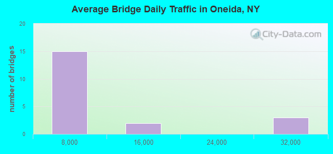
- 150,115Total average daily traffic
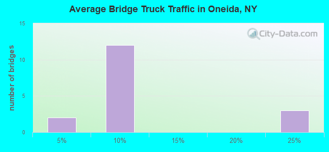
- 22,161Total average daily truck traffic
- National Bridge Inventory (NBI) Registered Bridges for Oneida
- No street view available for this location
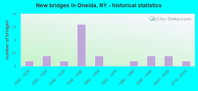
- New bridges - historical statistics
- 11920-1929
- 21930-1939
- 11940-1949
- 81950-1959
- 21960-1969
- 11980-1989
- 21990-1999
- 22000-2009
- 12010-2019
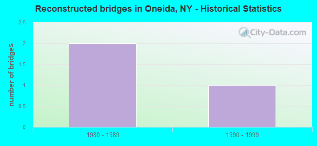
- Reconstructed bridges - Historical Statistics
- 21980-1989
- 11990-1999
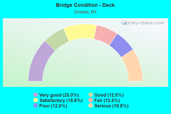
- Bridge Condition - Deck
- 25.0%Very good
- 12.5%Good
- 18.8%Satisfactory
- 12.5%Fair
- 12.5%Poor
- 18.8%Serious
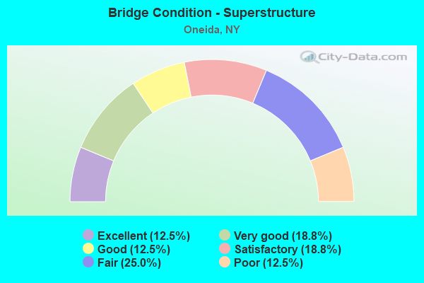
- Bridge Condition - Superstructure
- 12.5%Excellent
- 18.8%Very good
- 12.5%Good
- 18.8%Satisfactory
- 25.0%Fair
- 12.5%Poor
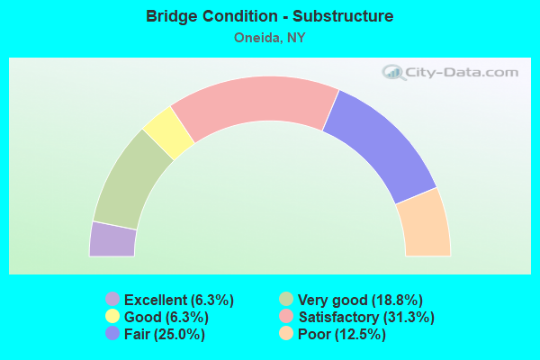
- Bridge Condition - Substructure
- 6.3%Excellent
- 18.8%Very good
- 6.3%Good
- 31.3%Satisfactory
- 25.0%Fair
- 12.5%Poor
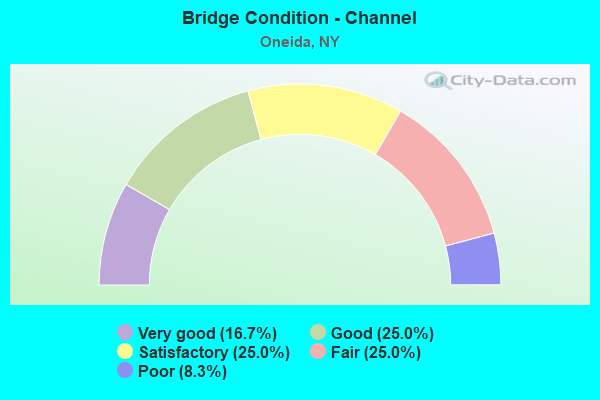
- Bridge Condition - Channel
- 16.7%Very good
- 25.0%Good
- 25.0%Satisfactory
- 25.0%Fair
- 8.3%Poor
Find on map >> Show street view
Structure Number: 102568, Location: 0.1 MI N JCT RTS 46 & 316 (Lat: 43.115206, Lng: -75.668828), Route carried "on" structure: State highway 46, Year Built: 1957, Status: Open, Structure Length: 5.09m (16.70ft), Average Daily Traffic: 3,106 (year 2018), Truck Traffic: 7%, Average Future Daily Traffic: 3,773 (year 2040), Design Load: HS 20, Features Intersected: ONEIDA CREEK
Minimum Vertical Clearance: 30+ m (98+ ft), Kilometerpoint: 0.000, Lanes on structure: 2, Base Highway Network: Yes, Owner: State Highway Agency, Approaching Roadway Width: 11.6m (38.1ft), Skew: 3 degrees, Material/Design: Steel, Design/Construction: Stringer/Multi-beam, Number Of Spans In Main Unit: 2, Length of Maximum Span: 25.2m (82.7ft), Curb-To-Curb Width: 11.6m (38.1ft), Out-to-Out Width: 13.2m (43.3ft)
Condition: Deck: Serious, Superstructure: Fair, Substructure: Poor, Channel: Satisfactory, Operating Rating: 61.6 metric tons, Method Used To Determine Operating Rating: Load and Resistance Factor Rating (LRFR) rating reported by rating factor(RF) method using HL-93 loadings, Inventory Rating: 47.6 metric tons, Method Used To Determine Inventory Rating: Load and Resistance Factor Rating (LRFR) rating reported by rating factor(RF) method using HL-93 loadings, Structural Evaluation: Meets minimum limits, Deck Geometry: Somewhat better than minimum adequacy, Waterway Adequacy: Somewhat better than minimum adequacy, Approach Roadway Alignment: Equal to present desirable criteria, Length Of Structure Improvement: 5.09m (16.70ft), Designated Inspection Frequency: Every 24 months, Inspection Date: October 2020, Bridge Improvement Cost: $1,101,000, Roadway Improvement Cost: $645,000, Total Project Cost: $1,745,000 ( Estimate for 2021), Deck Structure Type: Concrete Cast-file-Place, Wearing Surface/Protective System: Wearing Surface: Bituminous, Membrane: Other
Find on map >> Show street view
Structure Number: 104675, Location: .6 MI W JCT SH365 &SH365A (Lat: 43.092556, Lng: -75.640939), Route carried "on" structure: State highway 365A, Year Built: 1961, Status: Open, Structure Length: 3.41m (11.19ft), Average Daily Traffic: 5,730 (year 2015), Truck Traffic: 6%, Average Future Daily Traffic: 6,960 (year 2040), Design Load: HS 20, Features Intersected: ONEIDA CREEK
Minimum Vertical Clearance: 30+ m (98+ ft), Kilometerpoint: 0.000, Lanes on structure: 2, Base Highway Network: Yes, Owner: State Highway Agency, Approaching Roadway Width: 12.2m (40.0ft), Material/Design: Steel, Design/Construction: Stringer/Multi-beam, Number Of Spans In Main Unit: 2, Length of Maximum Span: 16.1m (52.8ft), Curb or Sidewalk Widths: Left: 1.5m (4.9ft), Right: 1.5m (4.9ft), Curb-To-Curb Width: 12.2m (40.0ft), Out-to-Out Width: 15.8m (51.8ft)
Condition: Deck: Fair, Superstructure: Satisfactory, Substructure: Fair, Channel: Good, Operating Rating: 83.5 metric tons, Method Used To Determine Operating Rating: Load Factor (LF), Inventory Rating: 49.9 metric tons, Method Used To Determine Inventory Rating: Load Factor (LF), Structural Evaluation: Somewhat better than minimum adequacy, Deck Geometry: Somewhat better than minimum adequacy, Waterway Adequacy: Somewhat better than minimum adequacy, Approach Roadway Alignment: Equal to present desirable criteria, Length Of Structure Improvement: 3.41m (11.19ft), Designated Inspection Frequency: Every 24 months, Inspection Date: July 2021, Bridge Improvement Cost: $918,000, Roadway Improvement Cost: $537,000, Total Project Cost: $1,455,000 ( Estimate for 2021), Deck Structure Type: Concrete Cast-file-Place, Wearing Surface/Protective System: Wearing Surface: Bituminous, Membrane: Other
Find on map >> Show street view
Structure Number: 202566, Location: NORTH END OF ONEIDA (Lat: 43.105739, Lng: -75.661314), Route carried "on" structure: State highway 46, Year Built: 2008, Status: Open, Structure Length: 2.87m (9.42ft), Average Daily Traffic: 5,701 (year 2020), Truck Traffic: 5%, Average Future Daily Traffic: 6,925 (year 2040), Design Load: HL 93, Features Intersected: CSX Trans/ Amtrak
Minimum Vertical Clearance: 30+ m (98+ ft), Kilometerpoint: 28.495, Lanes on structure: 2, Base Highway Network: Yes, Owner: Railroad, Maintenance Responsibility: State Highway Agency, Approaching Roadway Width: 12.2m (40.0ft), Material/Design: Prestressed concrete, Design/Construction: Box Beam or Girders - Multiple, Number Of Spans In Main Unit: 1, Length of Maximum Span: 26.9m (88.3ft), Curb-To-Curb Width: 12.1m (39.7ft), Out-to-Out Width: 13.1m (43.0ft)
Condition: Deck: Very good, Superstructure: Very good, Substructure: Very good, Operating Rating: 86.2 metric tons, Method Used To Determine Operating Rating: Load Factor (LF), Inventory Rating: 65.3 metric tons, Method Used To Determine Inventory Rating: Load Factor (LF), Structural Evaluation: Equal to present desirable criteria, Deck Geometry: Somewhat better than minimum adequacy, Underclear: Superior to present desirable criteria, Approach Roadway Alignment: Equal to present desirable criteria, Length Of Structure Improvement: 2.86m (9.38ft), Designated Inspection Frequency: Every 24 months, Inspection Date: September 2020, Bridge Improvement Cost: $1,216,000, Roadway Improvement Cost: $712,000, Total Project Cost: $1,928,000 ( Estimate for 2021), Deck Structure Type: Concrete Cast-file-Place, Wearing Surface/Protective System: Wearing Surface: Integral Concrete, Deck Protection: Epoxy Coated Reinforcing
Find on map >> Show street view
Structure Number: 225757, Location: IN CITY OF ONEIDA (Lat: 43.107572, Lng: -75.654597), Route carried "on" structure: City street , Year Built: 2010, Status: Open, Structure Length: 3.20m (10.50ft), Average Daily Traffic: 681 (year 2020), Truck Traffic: 5%, Average Future Daily Traffic: 842 (year 2040), Design Load: HL 93, Features Intersected: CSX TRANS/AMTRAK, Facility Carried by Structure: NORTH LAKE ST
Minimum Vertical Clearance: 30+ m (98+ ft), Kilometerpoint: 1.255, Lanes on structure: 2, Owner: County Highway Agency, Approaching Roadway Width: 10.1m (33.1ft), Skew: 1 degrees, Material/Design: Prestressed concrete, Design/Construction: Box Beam or Girders - Multiple, Number Of Spans In Main Unit: 1, Length of Maximum Span: 31.1m (102.0ft), Curb-To-Curb Width: 9.3m (30.5ft), Out-to-Out Width: 10.3m (33.8ft)
Condition: Deck: Satisfactory, Superstructure: Excellent, Substructure: Excellent, Operating Rating: 75.3 metric tons, Method Used To Determine Operating Rating: Load Factor (LF), Inventory Rating: 35.4 metric tons, Method Used To Determine Inventory Rating: Load Factor (LF), Structural Evaluation: Superior to present desirable criteria, Deck Geometry: Equal to present minimum criteria, Underclear: Superior to present desirable criteria, Approach Roadway Alignment: Equal to present desirable criteria, Length Of Structure Improvement: 3.20m (10.50ft), Designated Inspection Frequency: Every 24 months, Inspection Date: August 2020, Bridge Improvement Cost: $645,000, Roadway Improvement Cost: $378,000, Total Project Cost: $1,023,000 ( Estimate for 2021), Deck Structure Type: Concrete Cast-file-Place, Wearing Surface/Protective System: Wearing Surface: Integral Concrete, Deck Protection: Epoxy Coated Reinforcing
Find on map >> Show street view
Structure Number: 230936, Location: BENNETT RD-CITY ONEIDA LN (Lat: 43.105939, Lng: -75.648242), Route carried "on" structure: City street , Year Built: 1986, Status: Open, Structure Length: 2.80m (9.19ft), Average Daily Traffic: 311 (year 2018), Truck Traffic: 4%, Average Future Daily Traffic: 435 (year 2038), Design Load: HS 20, Features Intersected: ONEIDA CREEK, Facility Carried by Structure: BENNETT ROAD
Minimum Vertical Clearance: 30+ m (98+ ft), Kilometerpoint: 0.370, Lanes on structure: 2, Owner: County Highway Agency, Approaching Roadway Width: 6.7m (22.0ft), Skew: 1 degrees, Material/Design: Steel, Design/Construction: Stringer/Multi-beam, Number Of Spans In Main Unit: 1, Length of Maximum Span: 27.4m (89.9ft), Curb-To-Curb Width: 6.7m (22.0ft), Out-to-Out Width: 7.3m (24.0ft)
Condition: Deck: Good, Superstructure: Good, Substructure: Satisfactory, Channel: Fair, Operating Rating: 41.5 metric tons, Method Used To Determine Operating Rating: Load and Resistance Factor Rating (LRFR) rating reported by rating factor(RF) method using HL-93 loadings, Inventory Rating: 31.8 metric tons, Method Used To Determine Inventory Rating: Load and Resistance Factor Rating (LRFR) rating reported by rating factor(RF) method using HL-93 loadings, Structural Evaluation: Equal to present minimum criteria, Deck Geometry: Meets minimum limits, Waterway Adequacy: Meets minimum limits, Approach Roadway Alignment: Equal to present desirable criteria, Length Of Structure Improvement: 2.80m (9.19ft), Designated Inspection Frequency: Every 24 months, Inspection Date: June 2020, Bridge Improvement Cost: $518,000, Roadway Improvement Cost: $303,000, Total Project Cost: $821,000 ( Estimate for 2021), Deck Structure Type: Concrete Cast-file-Place, Wearing Surface/Protective System: Wearing Surface: Integral Concrete, Deck Protection: Epoxy Coated Reinforcing
Find on map >> Show street view
Structure Number: 330931, Location: 1 MI SW SHERRILL RES. (Lat: 43.045197, Lng: -75.599917), Route carried "on" structure: County highway , Year Built: 1964, Year Reconstructed: 1989, Status: Open, Structure Length: 1.71m (5.61ft), Average Daily Traffic: 1,499 (year 2020), Truck Traffic: 9%, Average Future Daily Traffic: 1,854 (year 2040), Features Intersected: ONEIDA CREEK, Facility Carried by Structure: CR34 PETERBORO RD
Minimum Vertical Clearance: 30+ m (98+ ft), Kilometerpoint: 9.203, Lanes on structure: 2, Owner: County Highway Agency, Approaching Roadway Width: 9.1m (29.9ft), Material/Design: Steel, Design/Construction: Stringer/Multi-beam, Number Of Spans In Main Unit: 1, Length of Maximum Span: 15.8m (51.8ft), Curb-To-Curb Width: 8.2m (26.9ft), Out-to-Out Width: 8.8m (28.9ft)
Condition: Deck: Very good, Superstructure: Good, Substructure: Satisfactory, Channel: Good, Inventory Rating: 65.3 metric tons, Method Used To Determine Inventory Rating: Load Factor (LF), Structural Evaluation: Equal to present minimum criteria, Deck Geometry: Meets minimum limits, Waterway Adequacy: Meets minimum limits, Approach Roadway Alignment: Better than present minimum criteria, Length Of Structure Improvement: 1.70m (5.58ft), Designated Inspection Frequency: Every 24 months, Inspection Date: April 2020, Bridge Improvement Cost: $357,000, Roadway Improvement Cost: $209,000, Total Project Cost: $565,000 ( Estimate for 2021), Deck Structure Type: Concrete Cast-file-Place, Wearing Surface/Protective System: Wearing Surface: Integral Concrete, Deck Protection: Epoxy Coated Reinforcing
Find on map >> Show street view
Structure Number: 330935, Location: 4 MI SE STATE BRIDGE (Lat: 43.097739, Lng: -75.639756), Route carried "on" structure: County highway , Year Built: 1998, Status: Open, Structure Length: 2.44m (8.01ft), Average Daily Traffic: 2,304 (year 2020), Truck Traffic: 5%, Average Future Daily Traffic: 2,850 (year 2040), Design Load: HS 25 or greater, Features Intersected: ONEIDA CREEK, Facility Carried by Structure: SCONONDOA STREET
Minimum Vertical Clearance: 30+ m (98+ ft), Kilometerpoint: 0.724, Lanes on structure: 2, Owner: County Highway Agency, Approaching Roadway Width: 9.1m (29.9ft), Skew: 1 degrees, Material/Design: Steel, Design/Construction: Stringer/Multi-beam, Number Of Spans In Main Unit: 1, Length of Maximum Span: 22.8m (74.8ft), Curb or Sidewalk Widths: Left: 0.0m, Right: 1.6m (5.2ft), Curb-To-Curb Width: 9.0m (29.5ft), Out-to-Out Width: 11.3m (37.1ft)
Condition: Deck: Very good, Superstructure: Very good, Substructure: Good, Channel: Fair, Operating Rating: 80.7 metric tons, Method Used To Determine Operating Rating: Load Factor (LF), Inventory Rating: 48.1 metric tons, Method Used To Determine Inventory Rating: Load Factor (LF), Structural Evaluation: Better than present minimum criteria, Deck Geometry: Meets minimum limits, Waterway Adequacy: Meets minimum limits, Approach Roadway Alignment: Equal to present desirable criteria, Length Of Structure Improvement: 2.43m (7.97ft), Designated Inspection Frequency: Every 24 months, Inspection Date: September 2020, Bridge Improvement Cost: $754,000, Roadway Improvement Cost: $442,000, Total Project Cost: $1,196,000 ( Estimate for 2021), Deck Structure Type: Concrete Cast-file-Place, Wearing Surface/Protective System: Wearing Surface: Integral Concrete, Deck Protection: Epoxy Coated Reinforcing
Find on map >> Show street view
Structure Number: 33094, Location: 2.0 MI NW OF ONEIDA (Lat: 43.097769, Lng: -75.691247), Route carried "on" structure: County highway , Year Built: 1940, Status: Open, Structure Length: 1.28m (4.20ft), Average Daily Traffic: 1,641 (year 2018), Truck Traffic: 6%, Average Future Daily Traffic: 2,030 (year 2040), Design Load: H 20, Features Intersected: COWASELON CREEK, Facility Carried by Structure: CR76 CANAL ROAD
Minimum Vertical Clearance: 30+ m (98+ ft), Kilometerpoint: 5.519, Lanes on structure: 2, Owner: County Highway Agency, Approaching Roadway Width: 6.1m (20.0ft), Material/Design: Steel, Design/Construction: Stringer/Multi-beam, Number Of Spans In Main Unit: 1, Length of Maximum Span: 12.1m (39.7ft), Curb or Sidewalk Widths: Left: 0.8m (2.6ft), Right: 0.8m (2.6ft), Curb-To-Curb Width: 6.7m (22.0ft), Out-to-Out Width: 9.1m (29.9ft)
Condition: Deck: Fair, Superstructure: Fair, Substructure: Satisfactory, Channel: Poor, Operating Rating: 45.4 metric tons, Method Used To Determine Operating Rating: Load Factor (LF), Inventory Rating: 27.2 metric tons, Method Used To Determine Inventory Rating: Load Factor (LF), Structural Evaluation: Somewhat better than minimum adequacy, Deck Geometry: High priority of corrective action, Waterway Adequacy: Equal to present desirable criteria, Approach Roadway Alignment: Equal to present minimum criteria, Length Of Structure Improvement: 1.28m (4.20ft), Designated Inspection Frequency: Every 24 months, Inspection Date: April 2020, Bridge Improvement Cost: $278,000, Roadway Improvement Cost: $163,000, Total Project Cost: $441,000 ( Estimate for 2021), Deck Structure Type: Concrete Cast-file-Place, Wearing Surface/Protective System: Wearing Surface: Bituminous
Find on map >> Show street view
Structure Number: 330941, Location: 2.0 MI SW OF ONEIDA (Lat: 43.083819, Lng: -75.693956), Route carried "on" structure: County highway , Year Built: 1931, Status: Open, Structure Length: 1.34m (4.40ft), Average Daily Traffic: 1,730 (year 2018), Truck Traffic: 3%, Average Future Daily Traffic: 2,140 (year 2040), Design Load: H 20, Features Intersected: COWASELON CREEK, Facility Carried by Structure: COUNTY ROAD 14
Minimum Vertical Clearance: 30+ m (98+ ft), Kilometerpoint: 1.126, Lanes on structure: 2, Owner: County Highway Agency, Approaching Roadway Width: 6.1m (20.0ft), Material/Design: Prestressed concrete, Design/Construction: Box Beam or Girders - Multiple, Number Of Spans In Main Unit: 1, Length of Maximum Span: 12.8m (42.0ft), Curb-To-Curb Width: 7.9m (25.9ft), Out-to-Out Width: 8.6m (28.2ft)
Condition: Deck: Satisfactory, Superstructure: Satisfactory, Substructure: Satisfactory, Channel: Satisfactory, Operating Rating: 58.5 metric tons, Method Used To Determine Operating Rating: Field evaluation and documented engineering judgment, Inventory Rating: 22.1 metric tons, Method Used To Determine Inventory Rating: Field evaluation and documented engineering judgment, Structural Evaluation: Somewhat better than minimum adequacy, Deck Geometry: Meets minimum limits, Waterway Adequacy: Meets minimum limits, Approach Roadway Alignment: Equal to present minimum criteria, Length Of Structure Improvement: 1.34m (4.40ft), Designated Inspection Frequency: Every 24 months, Inspection Date: September 2020, Bridge Improvement Cost: $299,000, Roadway Improvement Cost: $175,000, Total Project Cost: $474,000 ( Estimate for 2021), Wearing Surface/Protective System: Wearing Surface: Bituminous
Find on map >> Show street view
Structure Number: 330942, Location: 3.0 MI SW OF ONEIDA (Lat: 43.062514, Lng: -75.701103), Route carried "on" structure: County highway , Year Built: 2004, Status: Open, Structure Length: 1.68m (5.51ft), Average Daily Traffic: 1,901 (year 2018), Truck Traffic: 7%, Average Future Daily Traffic: 2,352 (year 2040), Features Intersected: COWASELON CREEK, Facility Carried by Structure: UPPER LENOX AVENUE
Minimum Vertical Clearance: 30+ m (98+ ft), Kilometerpoint: 0.225, Lanes on structure: 2, Owner: County Highway Agency, Approaching Roadway Width: 9.8m (32.2ft), Skew: 2 degrees, Material/Design: Prestressed concrete, Design/Construction: Box Beam or Girders - Multiple, Number Of Spans In Main Unit: 1, Length of Maximum Span: 15.2m (49.9ft), Curb-To-Curb Width: 9.0m (29.5ft), Out-to-Out Width: 9.9m (32.5ft)
Condition: Deck: Very good, Superstructure: Very good, Substructure: Very good, Channel: Satisfactory, Operating Rating: 53.5 metric tons, Method Used To Determine Operating Rating: Load Factor (LF), Inventory Rating: 14.5 metric tons, Method Used To Determine Inventory Rating: Load Factor (LF), Structural Evaluation: Meets minimum limits, Deck Geometry: Somewhat better than minimum adequacy, Waterway Adequacy: Meets minimum limits, Approach Roadway Alignment: Equal to present desirable criteria, Length Of Structure Improvement: 1.67m (5.48ft), Designated Inspection Frequency: Every 24 months, Inspection Date: April 2020, Bridge Improvement Cost: $386,000, Roadway Improvement Cost: $226,000, Total Project Cost: $612,000 ( Estimate for 2021), Wearing Surface/Protective System: Wearing Surface: Bituminous, Membrane: Other
Find on map >> Show street view
Structure Number: 331117, Location: 1.5 MI NW SHERRILL RSVOIR (Lat: 43.065025, Lng: -75.605294), Route carried "on" structure: City street , Year Built: 1939, Year Reconstructed: 1991, Status: Open, Structure Length: 1.77m (5.81ft), Average Daily Traffic: 1,607 (year 2018), Truck Traffic: 5%, Average Future Daily Traffic: 1,988 (year 2040), Features Intersected: ONEIDA CREEK, Facility Carried by Structure: SHERRILL ROAD
Minimum Vertical Clearance: 30+ m (98+ ft), Kilometerpoint: 1.368, Lanes on structure: 2, Owner: County Highway Agency, Approaching Roadway Width: 6.7m (22.0ft), Skew: 1 degrees, Material/Design: Prestressed concrete, Design/Construction: Box Beam or Girders - Multiple, Number Of Spans In Main Unit: 1, Length of Maximum Span: 15.8m (51.8ft), Curb or Sidewalk Widths: Left: 0.0m, Right: 1.6m (5.2ft), Curb-To-Curb Width: 6.7m (22.0ft), Out-to-Out Width: 8.6m (28.2ft)
Condition: Deck: Satisfactory, Superstructure: Satisfactory, Substructure: Satisfactory, Channel: Fair, Operating Rating: 63.5 metric tons, Method Used To Determine Operating Rating: Load and Resistance Factor Rating (LRFR) rating reported by rating factor(RF) method using HL-93 loadings, Inventory Rating: 33.0 metric tons, Method Used To Determine Inventory Rating: Load and Resistance Factor Rating (LRFR) rating reported by rating factor(RF) method using HL-93 loadings, Structural Evaluation: Equal to present minimum criteria, Deck Geometry: High priority of corrective action, Waterway Adequacy: Meets minimum limits, Approach Roadway Alignment: Equal to present minimum criteria, Length Of Structure Improvement: 1.76m (5.77ft), Designated Inspection Frequency: Every 24 months, Inspection Date: June 2021, Bridge Improvement Cost: $524,000, Roadway Improvement Cost: $307,000, Total Project Cost: $831,000 ( Estimate for 2021), Wearing Surface/Protective System: Wearing Surface: Bituminous
Find on map >> Show street view
Structure Number: 442411, Location: AT CITY OF ONEIDA (Lat: 43.103567, Lng: -75.683250), Route carried "on" structure: County highway , Year Built: 1925, Status: Posted for load, Structure Length: 0.73m (2.40ft), Average Daily Traffic: 641 (year 2019), Truck Traffic: 5%, Average Future Daily Traffic: 897 (year 2039), Features Intersected: OLD ERIE CANAL, Facility Carried by Structure: CR13 COBB STREET
Minimum Vertical Clearance: 30+ m (98+ ft), Kilometerpoint: 0.483, Lanes on structure: 2, Owner: State Highway Agency, Approaching Roadway Width: 6.1m (20.0ft), Material/Design: Steel, Design/Construction: Stringer/Multi-beam, Number Of Spans In Main Unit: 1, Length of Maximum Span: 6.0m (19.7ft), Curb-To-Curb Width: 6.1m (20.0ft), Out-to-Out Width: 7.0m (23.0ft)
Condition: Deck: Serious, Superstructure: Poor, Substructure: Fair, Channel: Very good, Operating Rating: 51.7 metric tons, Method Used To Determine Operating Rating: Load Factor (LF), Inventory Rating: 30.8 metric tons, Method Used To Determine Inventory Rating: Load Factor (LF), Structural Evaluation: Meets minimum limits, Deck Geometry: High priority of corrective action, Waterway Adequacy: Somewhat better than minimum adequacy, Approach Roadway Alignment: Meets minimum limits, Bridge Posting: Required (Relationship of Operating Rating to Maximum Legal Load: > 39.9% below), Length Of Structure Improvement: 0.73m (2.40ft), Designated Inspection Frequency: Every 12 months, Inspection Date: October 2021, Bridge Improvement Cost: $135,000, Roadway Improvement Cost: $79,000, Total Project Cost: $214,000 ( Estimate for 2021), Deck Structure Type: Concrete Cast-file-Place, Wearing Surface/Protective System: Wearing Surface: Bituminous
Find on map >> Show street view
Structure Number: 4512829, Location: 3.0 MI W JCT I90(Lat: 43.106964, Lng: -75.679792), Route carried "on" structure: Interstate 90, Year Built: 1953, Year Reconstructed: 1998, Status: Open, Structure Length: 1.04m (3.41ft), Average Daily Traffic: 29,351 (year 2020), Truck Traffic: 23%, Average Future Daily Traffic: 33,818 (year 2040), Design Load: HS 20+Mod, Features Intersected: OLD ERIE CANAL
Minimum Vertical Clearance: 30+ m (98+ ft), Kilometerpoint: 24.569, Lanes on structure: 4, Base Highway Network: Yes, Toll: On Interstate toll segment, Owner: State Toll Authority, Approaching Roadway Width: 24.1m (79.1ft), Skew: 24 degrees, Material/Design: Concrete, Design/Construction: Culvert, Number Of Spans In Main Unit: 2, Length of Maximum Span: 4.9m (16.1ft)
Condition: Channel: Good, Culverts: Satisfactory, Operating Rating: 75.7 metric tons, Method Used To Determine Operating Rating: Field evaluation and documented engineering judgment, Inventory Rating: 29.4 metric tons, Method Used To Determine Inventory Rating: Field evaluation and documented engineering judgment, Structural Evaluation: Equal to present minimum criteria, Waterway Adequacy: Meets minimum limits, Approach Roadway Alignment: Equal to present desirable criteria, Length Of Structure Improvement: 1.03m (3.38ft), Designated Inspection Frequency: Every 24 months, Inspection Date: July 2020, Bridge Improvement Cost: $1,052,000, Roadway Improvement Cost: $616,000, Total Project Cost: $1,668,000 ( Estimate for 2021), Wearing Surface/Protective System: Wearing Surface: Bituminous
Structure Number: 4512829, Location: 3.0 MI W JCT I90
Minimum Vertical Clearance: 30+ m (98+ ft), Kilometerpoint: 24.569, Lanes on structure: 4, Base Highway Network: Yes, Toll: On Interstate toll segment, Owner: State Toll Authority, Approaching Roadway Width: 24.1m (79.1ft), Skew: 24 degrees, Material/Design: Concrete, Design/Construction: Culvert, Number Of Spans In Main Unit: 2, Length of Maximum Span: 4.9m (16.1ft)
Condition: Channel: Good, Culverts: Satisfactory, Operating Rating: 75.7 metric tons, Method Used To Determine Operating Rating: Field evaluation and documented engineering judgment, Inventory Rating: 29.4 metric tons, Method Used To Determine Inventory Rating: Field evaluation and documented engineering judgment, Structural Evaluation: Equal to present minimum criteria, Waterway Adequacy: Meets minimum limits, Approach Roadway Alignment: Equal to present desirable criteria, Length Of Structure Improvement: 1.03m (3.38ft), Designated Inspection Frequency: Every 24 months, Inspection Date: July 2020, Bridge Improvement Cost: $1,052,000, Roadway Improvement Cost: $616,000, Total Project Cost: $1,668,000 ( Estimate for 2021), Wearing Surface/Protective System: Wearing Surface: Bituminous
Find on map >> Show street view
Structure Number: 502567, Location: 0.3 MI S JCT RTS 316 + 46 (Lat: 43.110497, Lng: -75.664875), Route carried "on" structure: State highway 46, Year Built: 1954, Status: Open, Structure Length: 6.13m (20.11ft), Average Daily Traffic: 5,701 (year 2020), Truck Traffic: 5%, Average Future Daily Traffic: 6,925 (year 2040), Design Load: HS 20, Features Intersected: 90 IX, RTE I90
Minimum Vertical Clearance: 30+ m (98+ ft), Kilometerpoint: 29.107, Lanes on structure: 2, Lanes under structure: 4, Base Highway Network: Yes, Owner: State Toll Authority, Approaching Roadway Width: 11.0m (36.1ft), Skew: 1 degrees, Material/Design: Steel continuous, Design/Construction: Stringer/Multi-beam, Number Of Spans In Main Unit: 4, Length of Maximum Span: 18.3m (60.0ft), Curb or Sidewalk Widths: Left: 0.6m (2.0ft), Right: 0.6m (2.0ft), Curb-To-Curb Width: 11.0m (36.1ft), Out-to-Out Width: 13.2m (43.3ft)
Condition: Deck: Poor, Superstructure: Fair, Substructure: Poor, Operating Rating: 55.3 metric tons, Method Used To Determine Operating Rating: Load Factor (LF), Inventory Rating: 32.7 metric tons, Method Used To Determine Inventory Rating: Load Factor (LF), Structural Evaluation: Meets minimum limits, Deck Geometry: Meets minimum limits, Underclear: High priority of corrective action, Approach Roadway Alignment: Equal to present desirable criteria, Length Of Structure Improvement: 6.12m (20.08ft), Designated Inspection Frequency: Every 24 months, Inspection Date: September 2020, Bridge Improvement Cost: $1,328,000, Roadway Improvement Cost: $778,000, Total Project Cost: $2,106,000 ( Estimate for 2021), Deck Structure Type: Concrete Cast-file-Place, Wearing Surface/Protective System: Wearing Surface: Bituminous
Find on map >> Show street view
Structure Number: 551281, Location: 4.0 MI E JCT I90(Lat: 43.106914, Lng: -75.680175), Route carried "on" structure: County highway , Year Built: 1953, Status: Open, Structure Length: 8.72m (28.61ft), Average Daily Traffic: 1,160 (year 2018), Truck Traffic: 8%, Average Future Daily Traffic: 1,435 (year 2040), Design Load: HS 20+Mod, Features Intersected: 90IX WB, RTE I90, Facility Carried by Structure: CANAL RD CR 76
Minimum Vertical Clearance: 30+ m (98+ ft), Kilometerpoint: 6.838, Lanes on structure: 2, Lanes under structure: 8, Owner: State Toll Authority, Approaching Roadway Width: 7.3m (24.0ft), Skew: 4 degrees, Material/Design: Steel, Design/Construction: Stringer/Multi-beam, Number Of Spans In Main Unit: 4, Length of Maximum Span: 25.6m (84.0ft), Curb or Sidewalk Widths: Left: 0.8m (2.6ft), Right: 0.8m (2.6ft), Curb-To-Curb Width: 7.9m (25.9ft), Out-to-Out Width: 10.1m (33.1ft)
Condition: Deck: Poor, Superstructure: Fair, Substructure: Fair, Operating Rating: 59.0 metric tons, Method Used To Determine Operating Rating: Load Factor (LF), Inventory Rating: 35.4 metric tons, Method Used To Determine Inventory Rating: Load Factor (LF), Structural Evaluation: Somewhat better than minimum adequacy, Deck Geometry: Meets minimum limits, Underclear: High priority of corrective action, Approach Roadway Alignment: Equal to present desirable criteria, Length Of Structure Improvement: 8.71m (28.58ft), Designated Inspection Frequency: Every 24 months, Inspection Date: July 2020, Bridge Improvement Cost: $1,440,000, Roadway Improvement Cost: $843,000, Total Project Cost: $2,283,000 ( Estimate for 2021), Deck Structure Type: Concrete Cast-file-Place, Wearing Surface/Protective System: Wearing Surface: Bituminous
Structure Number: 551281, Location: 4.0 MI E JCT I90
Minimum Vertical Clearance: 30+ m (98+ ft), Kilometerpoint: 6.838, Lanes on structure: 2, Lanes under structure: 8, Owner: State Toll Authority, Approaching Roadway Width: 7.3m (24.0ft), Skew: 4 degrees, Material/Design: Steel, Design/Construction: Stringer/Multi-beam, Number Of Spans In Main Unit: 4, Length of Maximum Span: 25.6m (84.0ft), Curb or Sidewalk Widths: Left: 0.8m (2.6ft), Right: 0.8m (2.6ft), Curb-To-Curb Width: 7.9m (25.9ft), Out-to-Out Width: 10.1m (33.1ft)
Condition: Deck: Poor, Superstructure: Fair, Substructure: Fair, Operating Rating: 59.0 metric tons, Method Used To Determine Operating Rating: Load Factor (LF), Inventory Rating: 35.4 metric tons, Method Used To Determine Inventory Rating: Load Factor (LF), Structural Evaluation: Somewhat better than minimum adequacy, Deck Geometry: Meets minimum limits, Underclear: High priority of corrective action, Approach Roadway Alignment: Equal to present desirable criteria, Length Of Structure Improvement: 8.71m (28.58ft), Designated Inspection Frequency: Every 24 months, Inspection Date: July 2020, Bridge Improvement Cost: $1,440,000, Roadway Improvement Cost: $843,000, Total Project Cost: $2,283,000 ( Estimate for 2021), Deck Structure Type: Concrete Cast-file-Place, Wearing Surface/Protective System: Wearing Surface: Bituminous
Find on map >> Show street view
Structure Number: 5512859, Location: 4 MI W EXIT 33 OF I90 (Lat: 43.112156, Lng: -75.659169), Route carried "on" structure: Interstate 90, Year Built: 1953, Status: Open, Structure Length: 5.43m (17.81ft), Average Daily Traffic: 29,351 (year 2020), Truck Traffic: 23%, Average Future Daily Traffic: 33,818 (year 2040), Design Load: HS 20+Mod, Features Intersected: N LAKE ST
Minimum Vertical Clearance: 30+ m (98+ ft), Kilometerpoint: 26.339, Lanes on structure: 4, Lanes under structure: 2, Base Highway Network: Yes, Toll: On Interstate toll segment, Owner: State Toll Authority, Approaching Roadway Width: 23.8m (78.1ft), Skew: 31 degrees, Material/Design: Steel continuous, Design/Construction: Stringer/Multi-beam, Number Of Spans In Main Unit: 3, Length of Maximum Span: 20.4m (66.9ft), Curb-To-Curb Width: 30.5m (100.1ft), Out-to-Out Width: 34.5m (113.2ft)
Condition: Deck: Serious, Superstructure: Poor, Substructure: Fair, Operating Rating: 40.8 metric tons, Method Used To Determine Operating Rating: Load Factor (LF), Inventory Rating: 24.5 metric tons, Method Used To Determine Inventory Rating: Load Factor (LF), Structural Evaluation: Meets minimum limits, Deck Geometry: Superior to present desirable criteria, Underclear: Meets minimum limits, Approach Roadway Alignment: Equal to present desirable criteria, Length Of Structure Improvement: 5.42m (17.78ft), Designated Inspection Frequency: Every 24 months, Inspection Date: October 2020, Bridge Improvement Cost: $3,138,000, Roadway Improvement Cost: $1,837,000, Total Project Cost: $4,975,000 ( Estimate for 2021), Deck Structure Type: Concrete Cast-file-Place, Wearing Surface/Protective System: Wearing Surface: Bituminous
Find on map >> Show street view
Structure Number: 5513059, Location: 3.8 MI W EXIT 33 OF I90 (Lat: 43.113331, Lng: -75.654422), Route carried "on" structure: Interstate 90, Year Built: 1994, Status: Open, Structure Length: 4.88m (16.01ft), Average Daily Traffic: 29,351 (year 2020), Truck Traffic: 23%, Average Future Daily Traffic: 33,818 (year 2040), Design Load: HS 20+Mod, Features Intersected: ONEIDA CREEK
Minimum Vertical Clearance: 30+ m (98+ ft), Kilometerpoint: 26.742, Lanes on structure: 4, Base Highway Network: Yes, Toll: On Interstate toll segment, Owner: State Toll Authority, Approaching Roadway Width: 29.9m (98.1ft), Skew: 30 degrees, Material/Design: Steel, Design/Construction: Stringer/Multi-beam, Number Of Spans In Main Unit: 1, Length of Maximum Span: 47.5m (155.8ft), Curb-To-Curb Width: 34.5m (113.2ft), Out-to-Out Width: 35.4m (116.1ft)
Condition: Deck: Good, Superstructure: Excellent, Substructure: Very good, Channel: Very good, Operating Rating: 76.2 metric tons, Method Used To Determine Operating Rating: Load Factor (LF), Inventory Rating: 45.4 metric tons, Method Used To Determine Inventory Rating: Load Factor (LF), Structural Evaluation: Equal to present desirable criteria, Deck Geometry: Superior to present desirable criteria, Waterway Adequacy: Meets minimum limits, Approach Roadway Alignment: Equal to present desirable criteria, Length Of Structure Improvement: 4.87m (15.98ft), Designated Inspection Frequency: Every 24 months, Inspection Date: June 2020, Bridge Improvement Cost: $3,226,000, Roadway Improvement Cost: $1,889,000, Total Project Cost: $5,115,000 ( Estimate for 2021), Deck Structure Type: Concrete Cast-file-Place, Wearing Surface/Protective System: Wearing Surface: Bituminous, Membrane: Other, Deck Protection: Galvanized Reinforcing
Find on map >> Show street view
Structure Number: 502567, Location: 0.3 MI S JCT RTS 316 + 46 (Lat: 43.110497, Lng: -75.664875), Route carried "under" structure: Interstate 90, Year Built: 1954, Structure Length: 0. m, Average Daily Traffic: 13,200 (year 1975), Features Intersected: 90 IX, RTE I90, Facility Carried by Structure: RTE 46
Minimum Vertical Clearance: 4.57m (14.99ft), Kilometerpoint: 413.658, Lanes on structure: 2, Lanes under structure: 2, Toll: On Interstate toll segment, Material/Design: Steel continuous, Design/Construction: Stringer/Multi-beam, Length of Maximum Span: 18.3m (60.0ft)
Find on map >> Show street view
Structure Number: 551281, Location: 4.0 MI E JCT I90(Lat: 43.106914, Lng: -75.680175), Route carried "under" structure: Interstate 90, Year Built: 1953, Structure Length: 0. m, Average Daily Traffic: 14,949 (year 1977), Features Intersected: 90IX WB, RTE I90, Facility Carried by Structure: CANAL RD CR 76
Minimum Vertical Clearance: 4.47m (14.67ft), Kilometerpoint: 414.961, Lanes on structure: 2, Lanes under structure: 4, Toll: On Interstate toll segment, Material/Design: Steel, Design/Construction: Stringer/Multi-beam, Length of Maximum Span: 25.6m (84.0ft)
Structure Number: 551281, Location: 4.0 MI E JCT I90
Minimum Vertical Clearance: 4.47m (14.67ft), Kilometerpoint: 414.961, Lanes on structure: 2, Lanes under structure: 4, Toll: On Interstate toll segment, Material/Design: Steel, Design/Construction: Stringer/Multi-beam, Length of Maximum Span: 25.6m (84.0ft)
Find on map >> Show street view
Structure Number: 5512859, Location: 4 MI W EXIT 33 OF I90 (Lat: 43.112156, Lng: -75.659169), Route carried "under" structure: City street , Year Built: 1953, Structure Length: 0. m, Average Daily Traffic: 200 (year 2000), Features Intersected: N LAKE ST, Facility Carried by Structure: RTE I90
Minimum Vertical Clearance: 6.17m (20.24ft), Kilometerpoint: 0.000, Lanes on structure: 4, Lanes under structure: 2, Material/Design: Steel continuous, Design/Construction: Stringer/Multi-beam, Length of Maximum Span: 20.4m (66.9ft)