Bridge Statistics for Ontario, Oregon (OR)
Condition, Traffic, Stress, Structural Evaluation, Project Costs
- National Bridge Inventory (NBI) Statistics
- 31Number of bridges
- 604ft / 184mTotal length
- $5,909,000Total costs
- 261,893Total average daily traffic
- 56,606Total average daily truck traffic
- National Bridge Inventory (NBI) Registered Bridges for Ontario
- No street view available for this location
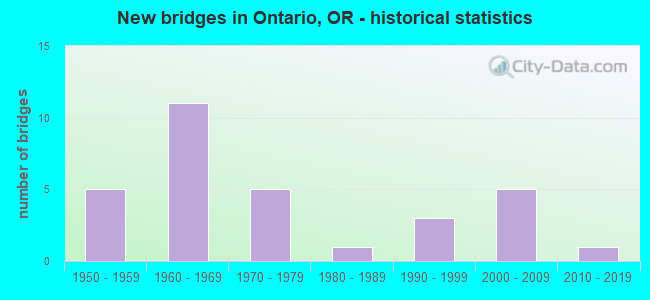
- New bridges - historical statistics
- 51950-1959
- 111960-1969
- 51970-1979
- 11980-1989
- 31990-1999
- 52000-2009
- 12010-2019
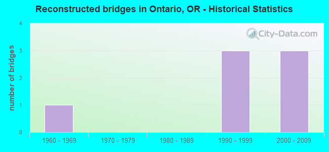
- Reconstructed bridges - Historical Statistics
- 11960-1969
- 01970-1979
- 01980-1989
- 31990-1999
- 32000-2009
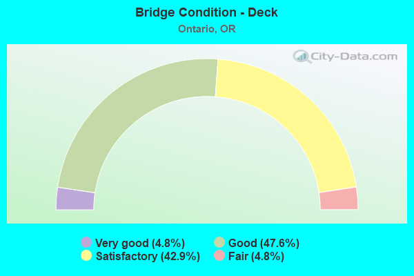
- Bridge Condition - Deck
- 4.8%Very good
- 47.6%Good
- 42.9%Satisfactory
- 4.8%Fair
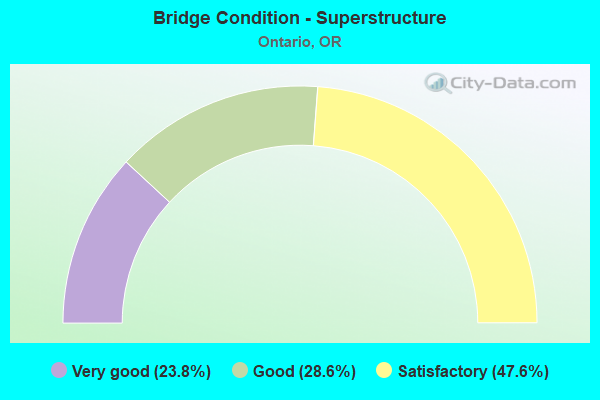
- Bridge Condition - Superstructure
- 23.8%Very good
- 28.6%Good
- 47.6%Satisfactory
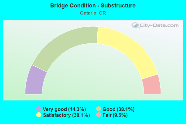
- Bridge Condition - Substructure
- 14.3%Very good
- 38.1%Good
- 38.1%Satisfactory
- 9.5%Fair
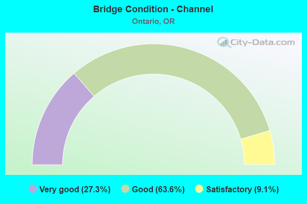
- Bridge Condition - Channel
- 27.3%Very good
- 63.6%Good
- 9.1%Satisfactory
Find on map >> Show street view
Structure Number: 731B455 0246, Location: 0.5 MI N JCT I-84N (Lat: 44.056386, Lng: -116.979008), Route carried "on" structure: State highway 201, Year Built: 1976, Status: Open, Structure Length: 11.67m (38.29ft), Average Daily Traffic: 11,657 (year 2020), Truck Traffic: 19%, Average Future Daily Traffic: 18,400 (year 2040), Design Load: HS 20, Features Intersected: MALHEUR RIVER
Minimum Vertical Clearance: 30+ m (98+ ft), Kilometerpoint: 39.590, Lanes on structure: 2, Base Highway Network: Yes, Owner: State Highway Agency, Approaching Roadway Width: 11.0m (36.1ft), Skew: 4 degrees, Material/Design: Prestressed concrete continuous, Design/Construction: Stringer/Multi-beam, Number Of Spans In Main Unit: 5, Length of Maximum Span: 24.4m (80.1ft), Curb-To-Curb Width: 12.2m (40.0ft), Out-to-Out Width: 13.3m (43.6ft)
Condition: Deck: Satisfactory, Superstructure: Satisfactory, Substructure: Fair, Channel: Satisfactory, Operating Rating: 52.2 metric tons, Method Used To Determine Operating Rating: Load and Resistance Factor Rating (LRFR) rating reported by rating factor(RF) method using HL-93 loadings, Inventory Rating: 40.2 metric tons, Method Used To Determine Inventory Rating: Load and Resistance Factor Rating (LRFR) rating reported by rating factor(RF) method using HL-93 loadings, Structural Evaluation: Somewhat better than minimum adequacy, Deck Geometry: Somewhat better than minimum adequacy, Waterway Adequacy: Equal to present desirable criteria, Approach Roadway Alignment: Equal to present desirable criteria, Designated Inspection Frequency: Every 24 months, Underwater Inspection Frequency: Every 60 months, Inspection Date: October 2020, Underwater Inspection Date: May 2020, Deck Structure Type: Concrete Cast-file-Place, Wearing Surface/Protective System: Wearing Surface: Monolithic Concrete
Find on map >> Show street view
Structure Number: 1091A087000181, Location: 013 E UPRR MAINLINE (Lat: 43.998211, Lng: -116.950531), Route carried "on" structure: County highway C0870, Year Built: 1987, Status: Open, Structure Length: 12.86m (42.19ft), Average Daily Traffic: 225 (year 2020), Truck Traffic: 20%, Average Future Daily Traffic: 265 (year 2025), Design Load: HS 25 or greater, Features Intersected: SNAKE RIVER, Facility Carried by Structure: FALK ISLAND C-870
Minimum Vertical Clearance: 30+ m (98+ ft), Kilometerpoint: 2.913, Lanes on structure: 2, Owner: County Highway Agency, Approaching Roadway Width: 7.3m (24.0ft), Skew: 3 degrees, Material/Design: Prestressed concrete, Design/Construction: Stringer/Multi-beam, Number Of Spans In Main Unit: 3, Length of Maximum Span: 42.7m (140.1ft), Curb-To-Curb Width: 7.6m (24.9ft), Out-to-Out Width: 8.2m (26.9ft)
Condition: Deck: Good, Superstructure: Good, Substructure: Good, Channel: Very good, Operating Rating: 49.6 metric tons, Method Used To Determine Operating Rating: Load and Resistance Factor Rating (LRFR) rating reported by rating factor(RF) method using HL-93 loadings, Inventory Rating: 38.2 metric tons, Method Used To Determine Inventory Rating: Load and Resistance Factor Rating (LRFR) rating reported by rating factor(RF) method using HL-93 loadings, Structural Evaluation: Better than present minimum criteria, Deck Geometry: Somewhat better than minimum adequacy, Waterway Adequacy: Equal to present desirable criteria, Approach Roadway Alignment: Equal to present desirable criteria, Designated Inspection Frequency: Every 24 months, Underwater Inspection Frequency: Every 60 months, Inspection Date: October 2021, Underwater Inspection Date: October 2021, Deck Structure Type: Concrete Cast-file-Place, Wearing Surface/Protective System: Wearing Surface: Monolithic Concrete
Find on map >> Show street view
Structure Number: 7935A006 37407, Location: 039 MI NW IDAHO STATE LN (Lat: 44.053364, Lng: -116.982581), Route carried "on" structure: Interstate 84, Year Built: 1973, Status: Open, Structure Length: 12.50m (41.01ft), Average Daily Traffic: 8,570 (year 2020), Truck Traffic: 27%, Average Future Daily Traffic: 10,400 (year 2040), Design Load: HS 20, Features Intersected: MALHEUR RIVER
Minimum Vertical Clearance: 30+ m (98+ ft), Kilometerpoint: 602.007, Lanes on structure: 2, Base Highway Network: Yes, Owner: State Highway Agency, Approaching Roadway Width: 12.2m (40.0ft), Skew: 13 degrees, Material/Design: Prestressed concrete, Design/Construction: Stringer/Multi-beam, Number Of Spans In Main Unit: 5, Length of Maximum Span: 25.9m (85.0ft), Curb-To-Curb Width: 12.8m (42.0ft), Out-to-Out Width: 13.9m (45.6ft)
Condition: Deck: Fair, Superstructure: Good, Substructure: Good, Channel: Good, Operating Rating: 31.1 metric tons, Method Used To Determine Operating Rating: Load and Resistance Factor Rating (LRFR) rating reported by rating factor(RF) method using HL-93 loadings, Inventory Rating: 24.0 metric tons, Method Used To Determine Inventory Rating: Load and Resistance Factor Rating (LRFR) rating reported by rating factor(RF) method using HL-93 loadings, Structural Evaluation: Somewhat better than minimum adequacy, Deck Geometry: Equal to present desirable criteria, Waterway Adequacy: Equal to present desirable criteria, Approach Roadway Alignment: Equal to present desirable criteria, Length Of Structure Improvement: 13.80m (45.28ft), Designated Inspection Frequency: Every 24 months, Underwater Inspection Frequency: Every 60 months, Inspection Date: March 2021, Underwater Inspection Date: October 2021, Bridge Improvement Cost: $1,455,000, Roadway Improvement Cost: $146,000, Total Project Cost: $2,328,000, Deck Structure Type: Concrete Cast-file-Place, Wearing Surface/Protective System: Wearing Surface: Monolithic Concrete
Find on map >> Show street view
Structure Number: 7935B006 37408, Location: 039 MI NW IDAHO STATE LN (Lat: 44.053342, Lng: -116.982153), Route carried "on" structure: Interstate 84, Year Built: 1973, Year Reconstructed: 2008, Status: Open, Structure Length: 10.45m (34.28ft), Average Daily Traffic: 8,570 (year 2020), Truck Traffic: 27%, Average Future Daily Traffic: 10,400 (year 2040), Design Load: HS 20, Features Intersected: MALHEUR RIVER
Minimum Vertical Clearance: 30+ m (98+ ft), Kilometerpoint: 602.023, Lanes on structure: 3, Base Highway Network: Yes, Owner: State Highway Agency, Approaching Roadway Width: 16.5m (54.1ft), Skew: 14 degrees, Material/Design: Prestressed concrete, Design/Construction: Stringer/Multi-beam, Number Of Spans In Main Unit: 5, Length of Maximum Span: 23.2m (76.1ft), Curb-To-Curb Width: 16.5m (54.1ft), Out-to-Out Width: 17.4m (57.1ft)
Condition: Deck: Good, Superstructure: Good, Substructure: Good, Channel: Good, Operating Rating: 26.9 metric tons, Method Used To Determine Operating Rating: Load and Resistance Factor Rating (LRFR) rating reported by rating factor(RF) method using HL-93 loadings, Inventory Rating: 20.7 metric tons, Method Used To Determine Inventory Rating: Load and Resistance Factor Rating (LRFR) rating reported by rating factor(RF) method using HL-93 loadings, Structural Evaluation: Somewhat better than minimum adequacy, Deck Geometry: Equal to present minimum criteria, Waterway Adequacy: Equal to present desirable criteria, Approach Roadway Alignment: Equal to present desirable criteria, Designated Inspection Frequency: Every 24 months, Underwater Inspection Frequency: Every 60 months, Inspection Date: March 2021, Underwater Inspection Date: October 2021, Deck Structure Type: Concrete Cast-file-Place, Wearing Surface/Protective System: Wearing Surface: Latex Concrete
Find on map >> Show street view
Structure Number: 7936A006 37048, Location: 07.5 MI NW IDAHO STATE LN (Lat: 44.092561, Lng: -117.029403), Route carried "on" structure: Interstate 84, Year Built: 1955, Year Reconstructed: 1972, Status: Open, Structure Length: 0.64m (2.10ft), Average Daily Traffic: 12,161 (year 2020), Truck Traffic: 27%, Average Future Daily Traffic: 13,900 (year 2040), Design Load: HS 20, Features Intersected: OWYHEE CANAL
Minimum Vertical Clearance: 30+ m (98+ ft), Kilometerpoint: 596.230, Lanes on structure: 4, Base Highway Network: Yes, Owner: State Highway Agency, Approaching Roadway Width: 52.1m (170.9ft), Skew: 11 degrees, Material/Design: Concrete continuous, Design/Construction: Culvert, Number Of Spans In Main Unit: 2, Length of Maximum Span: 3.0m (9.8ft)
Condition: Channel: Good, Culverts: Good, Operating Rating: 35.0 metric tons, Method Used To Determine Operating Rating: Load and Resistance Factor Rating (LRFR) rating reported by rating factor(RF) method using HL-93 loadings, Inventory Rating: 26.9 metric tons, Method Used To Determine Inventory Rating: Load and Resistance Factor Rating (LRFR) rating reported by rating factor(RF) method using HL-93 loadings, Structural Evaluation: Equal to present minimum criteria, Waterway Adequacy: Equal to present desirable criteria, Approach Roadway Alignment: Equal to present desirable criteria, Designated Inspection Frequency: Every 24 months, Inspection Date: March 2021
Find on map >> Show street view
Structure Number: 7956 006 37308, Location: 049 MI NW IDAHO ST LINE (Lat: 44.064667, Lng: -116.994722), Route carried "on" structure: County highway , Year Built: 1956, Status: Open, Structure Length: 5.91m (19.39ft), Average Daily Traffic: 1,393 (year 2010), Truck Traffic: 30%, Average Future Daily Traffic: 2,414 (year 2030), Design Load: HS 20, Features Intersected: I-84 (HWY 006), Facility Carried by Structure: CHESTER BLVD
Minimum Vertical Clearance: 30+ m (98+ ft), Kilometerpoint: 600.414, Lanes on structure: 2, Lanes under structure: 4, Owner: State Highway Agency, Approaching Roadway Width: 7.9m (25.9ft), Skew: 2 degrees, Material/Design: Concrete continuous, Design/Construction: Stringer/Multi-beam, Number Of Spans In Main Unit: 5, Length of Maximum Span: 16.2m (53.1ft), Curb-To-Curb Width: 7.7m (25.3ft), Out-to-Out Width: 8.5m (27.9ft)
Condition: Deck: Satisfactory, Superstructure: Satisfactory, Substructure: Satisfactory, Operating Rating: 42.6 metric tons, Method Used To Determine Operating Rating: Load Factor (LF), Inventory Rating: 25.4 metric tons, Method Used To Determine Inventory Rating: Load Factor (LF), Structural Evaluation: Equal to present minimum criteria, Deck Geometry: Meets minimum limits, Underclear: High priority of corrective action, Approach Roadway Alignment: Equal to present desirable criteria, Length Of Structure Improvement: 5.90m (19.36ft), Designated Inspection Frequency: Every 24 months, Inspection Date: March 2021, Bridge Improvement Cost: $560,000, Roadway Improvement Cost: $56,000, Total Project Cost: $896,000, Deck Structure Type: Concrete Cast-file-Place, Wearing Surface/Protective System: Wearing Surface: Latex Concrete
Find on map >> Show street view
Structure Number: 7970 006C37145, Location: 066 MI NW IDAHO STATE LN (Lat: 44.082586, Lng: -117.015794), Route carried "on" structure: Ramp Interstate 84, Year Built: 1956, Status: Open, Structure Length: 6.74m (22.11ft), Average Daily Traffic: 697 (year 2020), Truck Traffic: 46%, Average Future Daily Traffic: 3,497 (year 2030), Design Load: HS 20, Features Intersected: I-84 (HWY 006), Facility Carried by Structure: STANTON BLVD.
Minimum Vertical Clearance: 30+ m (98+ ft), Kilometerpoint: 597.791, Lanes on structure: 2, Lanes under structure: 6, Base Highway Network: Yes, Owner: State Highway Agency, Approaching Roadway Width: 8.2m (26.9ft), Skew: 3 degrees, Material/Design: Concrete continuous, Design/Construction: Stringer/Multi-beam, Number Of Spans In Main Unit: 5, Length of Maximum Span: 18.0m (59.1ft), Curb-To-Curb Width: 7.7m (25.3ft), Out-to-Out Width: 8.5m (27.9ft)
Condition: Deck: Good, Superstructure: Satisfactory, Substructure: Good, Operating Rating: 31.4 metric tons, Method Used To Determine Operating Rating: Load and Resistance Factor Rating (LRFR) rating reported by rating factor(RF) method using HL-93 loadings, Inventory Rating: 24.3 metric tons, Method Used To Determine Inventory Rating: Load and Resistance Factor Rating (LRFR) rating reported by rating factor(RF) method using HL-93 loadings, Structural Evaluation: Equal to present minimum criteria, Deck Geometry: High priority of replacement, Underclear: High priority of corrective action, Approach Roadway Alignment: Equal to present desirable criteria, Length Of Structure Improvement: 6.70m (21.98ft), Designated Inspection Frequency: Every 24 months, Inspection Date: March 2021, Bridge Improvement Cost: $644,000, Roadway Improvement Cost: $64,000, Total Project Cost: $1,030,000, Deck Structure Type: Concrete Cast-file-Place, Wearing Surface/Protective System: Wearing Surface: Latex Concrete
Find on map >> Show street view
Structure Number: 7971A006 37218, Location: 058 MI NW IDAHO STATE LN (Lat: 44.075203, Lng: -117.005278), Route carried "on" structure: Interstate 84, Year Built: 1972, Status: Open, Structure Length: 4.36m (14.30ft), Average Daily Traffic: 6,080 (year 2020), Truck Traffic: 27%, Average Future Daily Traffic: 6,950 (year 2040), Design Load: HS 20, Features Intersected: DOMAN ROAD
Minimum Vertical Clearance: 30+ m (98+ ft), Kilometerpoint: 598.966, Lanes on structure: 2, Lanes under structure: 2, Base Highway Network: Yes, Owner: State Highway Agency, Approaching Roadway Width: 12.8m (42.0ft), Skew: 11 degrees, Material/Design: Prestressed concrete, Design/Construction: Stringer/Multi-beam, Number Of Spans In Main Unit: 3, Length of Maximum Span: 16.5m (54.1ft), Curb-To-Curb Width: 12.8m (42.0ft), Out-to-Out Width: 13.9m (45.6ft)
Condition: Deck: Satisfactory, Superstructure: Good, Substructure: Good, Operating Rating: 24.0 metric tons, Method Used To Determine Operating Rating: Load and Resistance Factor Rating (LRFR) rating reported by rating factor(RF) method using HL-93 loadings, Inventory Rating: 18.5 metric tons, Method Used To Determine Inventory Rating: Load and Resistance Factor Rating (LRFR) rating reported by rating factor(RF) method using HL-93 loadings, Structural Evaluation: Meets minimum limits, Deck Geometry: Equal to present desirable criteria, Underclear: Somewhat better than minimum adequacy, Approach Roadway Alignment: Equal to present desirable criteria, Designated Inspection Frequency: Every 24 months, Inspection Date: March 2021, Deck Structure Type: Concrete Cast-file-Place, Wearing Surface/Protective System: Wearing Surface: Monolithic Concrete
Find on map >> Show street view
Structure Number: 8107E006 37792, Location: ORE-IDAHO STATE LINE (Lat: 44.007025, Lng: -116.941450), Route carried "on" structure: Interstate 84, Year Built: 1960, Year Reconstructed: 2007, Status: Open, Structure Length: 29.06m (95.34ft), Average Daily Traffic: 11,500 (year 2020), Truck Traffic: 23%, Average Future Daily Traffic: 13,900 (year 2040), Design Load: HS 20, Features Intersected: SNAKE RIVER
Minimum Vertical Clearance: 30+ m (98+ ft), Kilometerpoint: 608.348, Lanes on structure: 2, Base Highway Network: Yes, Owner: State Highway Agency, Approaching Roadway Width: 12.8m (42.0ft), Skew: 10 degrees, Navigation Control: Yes ( Vertical Clearance: 6.4m (21.0ft), Horizontal Clearance: 33.5m (109.9ft)), Material/Design: Steel, Design/Construction: Stringer/Multi-beam, Number Of Spans In Main Unit: 7, Number Of Approach Spans: 2, Length of Maximum Span: 38.7m (127.0ft), Curb-To-Curb Width: 9.7m (31.8ft), Out-to-Out Width: 10.6m (34.8ft)
Condition: Deck: Satisfactory, Superstructure: Satisfactory, Substructure: Satisfactory, Channel: Good, Operating Rating: 41.1 metric tons, Method Used To Determine Operating Rating: Load and Resistance Factor Rating (LRFR) rating reported by rating factor(RF) method using HL-93 loadings, Inventory Rating: 31.8 metric tons, Method Used To Determine Inventory Rating: Load and Resistance Factor Rating (LRFR) rating reported by rating factor(RF) method using HL-93 loadings, Structural Evaluation: Equal to present minimum criteria, Deck Geometry: Meets minimum limits, Waterway Adequacy: Equal to present desirable criteria, Approach Roadway Alignment: Equal to present desirable criteria, Designated Inspection Frequency: Every 24 months, Underwater Inspection Frequency: Every 36 months, Inspection Date: May 2021, Underwater Inspection Date: September 2020, Deck Structure Type: Concrete Cast-file-Place, Wearing Surface/Protective System: Wearing Surface: Latex Concrete
Find on map >> Show street view
Structure Number: 8107W006 37792, Location: ORE-IDAHO STATE LINE (Lat: 44.007108, Lng: -116.941100), Route carried "on" structure: Interstate 84, Year Built: 1960, Year Reconstructed: 2008, Status: Open, Structure Length: 29.06m (95.34ft), Average Daily Traffic: 11,500 (year 2020), Truck Traffic: 23%, Average Future Daily Traffic: 13,900 (year 2040), Design Load: HS 20, Features Intersected: SNAKE RIVER
Minimum Vertical Clearance: 30+ m (98+ ft), Kilometerpoint: 608.348, Lanes on structure: 2, Base Highway Network: Yes, Owner: State Highway Agency, Approaching Roadway Width: 12.8m (42.0ft), Skew: 10 degrees, Navigation Control: Yes ( Vertical Clearance: 6.4m (21.0ft), Horizontal Clearance: 33.5m (109.9ft)), Material/Design: Steel, Design/Construction: Stringer/Multi-beam, Number Of Spans In Main Unit: 7, Number Of Approach Spans: 2, Length of Maximum Span: 38.7m (127.0ft), Curb-To-Curb Width: 9.7m (31.8ft), Out-to-Out Width: 10.6m (34.8ft)
Condition: Deck: Satisfactory, Superstructure: Satisfactory, Substructure: Satisfactory, Channel: Good, Operating Rating: 41.1 metric tons, Method Used To Determine Operating Rating: Load and Resistance Factor Rating (LRFR) rating reported by rating factor(RF) method using HL-93 loadings, Inventory Rating: 31.8 metric tons, Method Used To Determine Inventory Rating: Load and Resistance Factor Rating (LRFR) rating reported by rating factor(RF) method using HL-93 loadings, Structural Evaluation: Equal to present minimum criteria, Deck Geometry: Meets minimum limits, Waterway Adequacy: Equal to present desirable criteria, Approach Roadway Alignment: Equal to present desirable criteria, Designated Inspection Frequency: Every 24 months, Underwater Inspection Frequency: Every 36 months, Inspection Date: May 2021, Underwater Inspection Date: September 2020, Deck Structure Type: Concrete Cast-file-Place, Wearing Surface/Protective System: Wearing Surface: Latex Concrete
Find on map >> Show street view
Structure Number: 8397E006 3758, Location: 022 MI NW IDAHO STATE LN (Lat: 44.035714, Lng: -116.958211), Route carried "on" structure: Interstate 84, Year Built: 1960, Year Reconstructed: 1996, Status: Open, Structure Length: 5.46m (17.91ft), Average Daily Traffic: 11,500 (year 2020), Truck Traffic: 23%, Average Future Daily Traffic: 13,900 (year 2040), Design Load: H 20, Features Intersected: UPRR (ORE-IDA)
Minimum Vertical Clearance: 30+ m (98+ ft), Kilometerpoint: 604.791, Lanes on structure: 2, Base Highway Network: Yes, Owner: State Highway Agency, Approaching Roadway Width: 12.2m (40.0ft), Skew: 12 degrees, Material/Design: Concrete continuous, Design/Construction: Stringer/Multi-beam, Number Of Spans In Main Unit: 3, Length of Maximum Span: 21.3m (69.9ft), Curb-To-Curb Width: 13.5m (44.3ft), Out-to-Out Width: 14.2m (46.6ft)
Condition: Deck: Good, Superstructure: Satisfactory, Substructure: Satisfactory, Operating Rating: 37.2 metric tons, Method Used To Determine Operating Rating: Load Factor (LF), Inventory Rating: 22.7 metric tons, Method Used To Determine Inventory Rating: Load Factor (LF), Structural Evaluation: Somewhat better than minimum adequacy, Deck Geometry: Superior to present desirable criteria, Underclear: Better than present minimum criteria, Approach Roadway Alignment: Equal to present desirable criteria, Designated Inspection Frequency: Every 24 months, Inspection Date: March 2021, Deck Structure Type: Concrete Cast-file-Place, Wearing Surface/Protective System: Wearing Surface: Bituminous, Membrane: Preformed Fabric
Find on map >> Show street view
Structure Number: 8397W006 3758, Location: 022 MI NW IDAHO STATE LN (Lat: 44.035917, Lng: -116.958150), Route carried "on" structure: Interstate 84, Year Built: 1960, Year Reconstructed: 1996, Status: Open, Structure Length: 5.46m (17.91ft), Average Daily Traffic: 11,500 (year 2020), Truck Traffic: 23%, Average Future Daily Traffic: 13,900 (year 2040), Design Load: H 20, Features Intersected: UPRR (ORE-IDA)
Minimum Vertical Clearance: 30+ m (98+ ft), Kilometerpoint: 604.791, Lanes on structure: 2, Base Highway Network: Yes, Owner: State Highway Agency, Approaching Roadway Width: 12.2m (40.0ft), Skew: 12 degrees, Material/Design: Concrete continuous, Design/Construction: Stringer/Multi-beam, Number Of Spans In Main Unit: 3, Length of Maximum Span: 21.3m (69.9ft), Curb-To-Curb Width: 13.5m (44.3ft), Out-to-Out Width: 14.2m (46.6ft)
Condition: Deck: Good, Superstructure: Satisfactory, Substructure: Satisfactory, Operating Rating: 37.2 metric tons, Method Used To Determine Operating Rating: Load Factor (LF), Inventory Rating: 22.7 metric tons, Method Used To Determine Inventory Rating: Load Factor (LF), Structural Evaluation: Somewhat better than minimum adequacy, Deck Geometry: Superior to present desirable criteria, Underclear: Better than present minimum criteria, Approach Roadway Alignment: Equal to present desirable criteria, Designated Inspection Frequency: Every 24 months, Inspection Date: March 2021, Deck Structure Type: Concrete Cast-file-Place, Wearing Surface/Protective System: Wearing Surface: Bituminous, Membrane: Preformed Fabric
Find on map >> Show street view
Structure Number: 8398E006 376, Location: 020 MI NW IDAHO STATE LN (Lat: 44.034075, Lng: -116.955058), Route carried "on" structure: Interstate 84, Year Built: 1960, Status: Open, Structure Length: 3.69m (12.11ft), Average Daily Traffic: 11,500 (year 2020), Truck Traffic: 23%, Average Future Daily Traffic: 13,900 (year 2040), Design Load: HS 20, Features Intersected: GRIGG ROAD
Minimum Vertical Clearance: 30+ m (98+ ft), Kilometerpoint: 605.113, Lanes on structure: 2, Lanes under structure: 2, Base Highway Network: Yes, Owner: State Highway Agency, Approaching Roadway Width: 12.2m (40.0ft), Skew: 10 degrees, Material/Design: Concrete continuous, Design/Construction: Stringer/Multi-beam, Number Of Spans In Main Unit: 3, Length of Maximum Span: 14.6m (47.9ft), Curb-To-Curb Width: 12.7m (41.7ft), Out-to-Out Width: 13.6m (44.6ft)
Condition: Deck: Satisfactory, Superstructure: Satisfactory, Substructure: Satisfactory, Operating Rating: 55.3 metric tons, Method Used To Determine Operating Rating: Load Factor (LF), Inventory Rating: 32.7 metric tons, Method Used To Determine Inventory Rating: Load Factor (LF), Structural Evaluation: Equal to present minimum criteria, Deck Geometry: Better than present minimum criteria, Underclear: Meets minimum limits, Approach Roadway Alignment: Equal to present desirable criteria, Designated Inspection Frequency: Every 24 months, Inspection Date: March 2021, Deck Structure Type: Concrete Cast-file-Place, Wearing Surface/Protective System: Wearing Surface: Bituminous
Find on map >> Show street view
Structure Number: 8398W006 376, Location: 020 MI NW IDAHO STATE LN (Lat: 44.034247, Lng: -116.954858), Route carried "on" structure: Interstate 84, Year Built: 1960, Status: Open, Structure Length: 3.69m (12.11ft), Average Daily Traffic: 11,500 (year 2020), Truck Traffic: 23%, Average Future Daily Traffic: 13,900 (year 2040), Design Load: HS 20, Features Intersected: GRIGG ROAD
Minimum Vertical Clearance: 30+ m (98+ ft), Kilometerpoint: 605.113, Lanes on structure: 2, Lanes under structure: 2, Base Highway Network: Yes, Owner: State Highway Agency, Approaching Roadway Width: 12.2m (40.0ft), Skew: 10 degrees, Material/Design: Concrete continuous, Design/Construction: Stringer/Multi-beam, Number Of Spans In Main Unit: 3, Length of Maximum Span: 14.6m (47.9ft), Curb-To-Curb Width: 12.7m (41.7ft), Out-to-Out Width: 13.6m (44.6ft)
Condition: Deck: Satisfactory, Superstructure: Satisfactory, Substructure: Satisfactory, Operating Rating: 55.3 metric tons, Method Used To Determine Operating Rating: Load Factor (LF), Inventory Rating: 32.7 metric tons, Method Used To Determine Inventory Rating: Load Factor (LF), Structural Evaluation: Equal to present minimum criteria, Deck Geometry: Better than present minimum criteria, Underclear: Meets minimum limits, Approach Roadway Alignment: Equal to present desirable criteria, Designated Inspection Frequency: Every 24 months, Inspection Date: March 2021, Deck Structure Type: Concrete Cast-file-Place, Wearing Surface/Protective System: Wearing Surface: Bituminous
Find on map >> Show street view
Structure Number: 8400 006 37698, Location: 010 MI N IDAHO STATE LINE (Lat: 44.021211, Lng: -116.947369), Route carried "on" structure: City street , Year Built: 1960, Status: Open, Structure Length: 7.99m (26.21ft), Average Daily Traffic: 2,297 (year 2010), Truck Traffic: 5%, Average Future Daily Traffic: 3,292 (year 2030), Design Load: HS 20, Features Intersected: I-84 (HWY 006), Facility Carried by Structure: SE 5TH AVENUE
Minimum Vertical Clearance: 30+ m (98+ ft), Kilometerpoint: 606.690, Lanes on structure: 2, Lanes under structure: 5, Owner: State Highway Agency, Approaching Roadway Width: 7.9m (25.9ft), Skew: 1 degrees, Material/Design: Concrete continuous, Design/Construction: Stringer/Multi-beam, Number Of Spans In Main Unit: 5, Length of Maximum Span: 17.7m (58.1ft), Curb or Sidewalk Widths: Left: 1.5m (4.9ft), Right: 1.5m (4.9ft), Curb-To-Curb Width: 8.0m (26.2ft), Out-to-Out Width: 11.6m (38.1ft)
Condition: Deck: Satisfactory, Superstructure: Satisfactory, Substructure: Satisfactory, Operating Rating: 24.3 metric tons, Method Used To Determine Operating Rating: Load and Resistance Factor Rating (LRFR) rating reported by rating factor(RF) method using HL-93 loadings, Inventory Rating: 18.8 metric tons, Method Used To Determine Inventory Rating: Load and Resistance Factor Rating (LRFR) rating reported by rating factor(RF) method using HL-93 loadings, Structural Evaluation: Somewhat better than minimum adequacy, Deck Geometry: High priority of corrective action, Underclear: High priority of corrective action, Approach Roadway Alignment: Equal to present desirable criteria, Length Of Structure Improvement: 8.00m (26.25ft), Designated Inspection Frequency: Every 24 months, Inspection Date: March 2021, Bridge Improvement Cost: $1,034,000, Roadway Improvement Cost: $103,000, Total Project Cost: $1,655,000, Deck Structure Type: Concrete Cast-file-Place, Wearing Surface/Protective System: Wearing Surface: Monolithic Concrete
Find on map >> Show street view
Structure Number: 17192 006C37145, Location: 1.75 MI W. JCT I-84 (Lat: 44.082783, Lng: -117.017764), Route carried "on" structure: Other road 40084, Year Built: 1991, Status: Open, Structure Length: 1.71m (5.61ft), Average Daily Traffic: 5 (year 2020), Truck Traffic: 40%, Average Future Daily Traffic: 30 (year 2030), Design Load: HS 25 or greater, Features Intersected: OWYHEE CANAL, Facility Carried by Structure: HWY 457
Minimum Vertical Clearance: 30+ m (98+ ft), Kilometerpoint: 0.950, Lanes on structure: 2, Base Highway Network: Yes, Owner: State Highway Agency, Approaching Roadway Width: 9.8m (32.2ft), Skew: 4 degrees, Material/Design: Prestressed concrete, Design/Construction: Slab, Number Of Spans In Main Unit: 1, Length of Maximum Span: 15.8m (51.8ft), Curb-To-Curb Width: 10.8m (35.4ft), Out-to-Out Width: 11.0m (36.1ft)
Condition: Deck: Good, Superstructure: Good, Substructure: Good, Channel: Good, Operating Rating: 41.1 metric tons, Method Used To Determine Operating Rating: Load and Resistance Factor Rating (LRFR) rating reported by rating factor(RF) method using HL-93 loadings, Inventory Rating: 31.8 metric tons, Method Used To Determine Inventory Rating: Load and Resistance Factor Rating (LRFR) rating reported by rating factor(RF) method using HL-93 loadings, Structural Evaluation: Better than present minimum criteria, Deck Geometry: Superior to present desirable criteria, Waterway Adequacy: Equal to present desirable criteria, Approach Roadway Alignment: Equal to present desirable criteria, Designated Inspection Frequency: Every 24 months, Inspection Date: March 2021, Deck Structure Type: Concrete Precast Panels, Wearing Surface/Protective System: Wearing Surface: Bituminous, Deck Protection: Epoxy Coated Reinforcing
Find on map >> Show street view
Structure Number: 18097 455Y02773, Location: 1.7 MI. W. OR-ID LINE (Lat: 44.024739, Lng: -116.948869), Route carried "on" structure: Spur US 30, Year Built: 1998, Status: Open, Structure Length: 9.20m (30.18ft), Average Daily Traffic: 23,212 (year 2020), Truck Traffic: 3%, Average Future Daily Traffic: 23,300 (year 2040), Design Load: HS 25 or greater, Features Intersected: I-84 (HWY 6 MP 376.72)
Minimum Vertical Clearance: 30+ m (98+ ft), Kilometerpoint: 44.627, Lanes on structure: 5, Lanes under structure: 6, Base Highway Network: Yes, Owner: State Highway Agency, Approaching Roadway Width: 20.4m (66.9ft), Skew: 21 degrees, Material/Design: Prestressed concrete continuous, Design/Construction: Box Beam or Girders - Multiple, Number Of Spans In Main Unit: 2, Length of Maximum Span: 46.0m (150.9ft), Curb or Sidewalk Widths: Left: 2.3m (7.5ft), Right: 2.3m (7.5ft), Curb-To-Curb Width: 25.3m (83.0ft), Out-to-Out Width: 31.4m (103.0ft)
Condition: Deck: Good, Superstructure: Very good, Substructure: Good, Operating Rating: 20.7 metric tons, Method Used To Determine Operating Rating: Load and Resistance Factor Rating (LRFR) rating reported by rating factor(RF) method using HL-93 loadings, Inventory Rating: 16.2 metric tons, Method Used To Determine Inventory Rating: Load and Resistance Factor Rating (LRFR) rating reported by rating factor(RF) method using HL-93 loadings, Structural Evaluation: Meets minimum limits, Deck Geometry: Superior to present desirable criteria, Underclear: Equal to present minimum criteria, Approach Roadway Alignment: Equal to present desirable criteria, Designated Inspection Frequency: Every 24 months, Inspection Date: October 2020, Deck Structure Type: Concrete Cast-file-Place, Wearing Surface/Protective System: Wearing Surface: Monolithic Concrete, Deck Protection: Epoxy Coated Reinforcing
Find on map >> Show street view
Structure Number: 18724, Location: BETWEEN 2ND ST AND 4TH ST (Lat: 44.010111, Lng: -116.966464), Route carried "on" structure: County highway , Year Built: 2003, Status: Open, Structure Length: 5.33m (17.49ft), Average Daily Traffic: 1,639 (year 2020), Truck Traffic: 2%, Average Future Daily Traffic: 1,924 (year 2025), Design Load: HS 25 or greater, Features Intersected: UPRR, Facility Carried by Structure: SW 18TH AVE
Minimum Vertical Clearance: 30+ m (98+ ft), Kilometerpoint: 0.000, Lanes on structure: 2, Owner: County Highway Agency, Approaching Roadway Width: 12.2m (40.0ft), Skew: 1 degrees, Material/Design: Steel, Design/Construction: Stringer/Multi-beam, Number Of Spans In Main Unit: 1, Length of Maximum Span: 52.0m (170.6ft), Curb or Sidewalk Widths: Left: 2.1m (6.9ft), Right: 0.0m, Curb-To-Curb Width: 11.9m (39.0ft), Out-to-Out Width: 14.9m (48.9ft)
Condition: Deck: Good, Superstructure: Very good, Substructure: Very good, Channel: Very good, Operating Rating: 52.2 metric tons, Method Used To Determine Operating Rating: Load and Resistance Factor Rating (LRFR) rating reported by rating factor(RF) method using HL-93 loadings, Inventory Rating: 40.2 metric tons, Method Used To Determine Inventory Rating: Load and Resistance Factor Rating (LRFR) rating reported by rating factor(RF) method using HL-93 loadings, Structural Evaluation: Equal to present desirable criteria, Deck Geometry: Equal to present minimum criteria, Approach Roadway Alignment: Equal to present desirable criteria, Designated Inspection Frequency: Every 24 months, Inspection Date: October 2021, Deck Structure Type: Concrete Cast-file-Place, Wearing Surface/Protective System: Wearing Surface: Integral Concrete, Deck Protection: Epoxy Coated Reinforcing
Find on map >> Show street view
Structure Number: 20378 006 37218, Location: 058 MI NW IDAHO STATE LN (Lat: 44.075064, Lng: -117.005467), Route carried "on" structure: Interstate 84, Year Built: 2007, Status: Open, Structure Length: 3.51m (11.52ft), Average Daily Traffic: 6,080 (year 2020), Truck Traffic: 27%, Average Future Daily Traffic: 6,950 (year 2040), Design Load: HL 93, Features Intersected: DOMAN ROAD
Minimum Vertical Clearance: 30+ m (98+ ft), Kilometerpoint: 598.966, Lanes on structure: 2, Lanes under structure: 2, Base Highway Network: Yes, Owner: State Highway Agency, Approaching Roadway Width: 12.8m (42.0ft), Skew: 11 degrees, Material/Design: Prestressed concrete, Design/Construction: Stringer/Multi-beam, Number Of Spans In Main Unit: 1, Length of Maximum Span: 34.4m (112.9ft), Curb-To-Curb Width: 12.8m (42.0ft), Out-to-Out Width: 13.6m (44.6ft)
Condition: Deck: Very good, Superstructure: Very good, Substructure: Very good, Operating Rating: 66.1 metric tons, Method Used To Determine Operating Rating: Load and Resistance Factor Rating (LRFR) rating reported by rating factor(RF) method using HL-93 loadings, Inventory Rating: 50.9 metric tons, Method Used To Determine Inventory Rating: Load and Resistance Factor Rating (LRFR) rating reported by rating factor(RF) method using HL-93 loadings, Structural Evaluation: Equal to present desirable criteria, Deck Geometry: Equal to present desirable criteria, Underclear: High priority of corrective action, Approach Roadway Alignment: Equal to present desirable criteria, Designated Inspection Frequency: Every 24 months, Inspection Date: March 2021, Deck Structure Type: Concrete Cast-file-Place, Wearing Surface/Protective System: Wearing Surface: Monolithic Concrete, Deck Protection: Epoxy Coated Reinforcing
Find on map >> Show street view
Structure Number: 20398 455 0252, Location: 0.3 MI N ONTARIO NW C LMT (Lat: 44.048731, Lng: -116.976481), Route carried "on" structure: State highway 201, Year Built: 2008, Status: Open, Structure Length: 7.65m (25.10ft), Average Daily Traffic: 11,657 (year 2020), Truck Traffic: 19%, Average Future Daily Traffic: 18,400 (year 2040), Design Load: HL 93, Features Intersected: I-84 (HWY 6 MP 374.55)
Minimum Vertical Clearance: 30+ m (98+ ft), Kilometerpoint: 40.555, Lanes on structure: 2, Lanes under structure: 5, Base Highway Network: Yes, Owner: State Highway Agency, Approaching Roadway Width: 17.4m (57.1ft), Skew: 3 degrees, Material/Design: Prestressed concrete continuous, Design/Construction: Stringer/Multi-beam, Number Of Spans In Main Unit: 2, Length of Maximum Span: 39.6m (129.9ft), Curb or Sidewalk Widths: Left: 3.3m (10.8ft), Right: 0.0m, Curb-To-Curb Width: 17.4m (57.1ft), Out-to-Out Width: 21.9m (71.9ft)
Condition: Deck: Good, Superstructure: Very good, Substructure: Good, Operating Rating: 51.2 metric tons, Method Used To Determine Operating Rating: Load and Resistance Factor Rating (LRFR) rating reported by rating factor(RF) method using HL-93 loadings, Inventory Rating: 39.5 metric tons, Method Used To Determine Inventory Rating: Load and Resistance Factor Rating (LRFR) rating reported by rating factor(RF) method using HL-93 loadings, Structural Evaluation: Better than present minimum criteria, Deck Geometry: Superior to present desirable criteria, Underclear: Equal to present minimum criteria, Approach Roadway Alignment: Equal to present desirable criteria, Designated Inspection Frequency: Every 24 months, Inspection Date: October 2020, Deck Structure Type: Concrete Cast-file-Place, Wearing Surface/Protective System: Wearing Surface: Monolithic Concrete, Deck Protection: Epoxy Coated Reinforcing
Find on map >> Show street view
Structure Number: 22061 537 00105, Location: 0.05 MI N MALHEUR AVE (Lat: 44.040472, Lng: -117.020442), Route carried "on" structure: County highway C0537, Year Built: 2013, Status: Open, Structure Length: 6.52m (21.39ft), Average Daily Traffic: 529 (year 2020), Truck Traffic: 20%, Average Future Daily Traffic: 649 (year 2025), Design Load: HS 20, Features Intersected: MALHEUR RIVER, Facility Carried by Structure: NW 36TH STREET
Minimum Vertical Clearance: 30+ m (98+ ft), Kilometerpoint: 1.690, Lanes on structure: 2, Owner: County Highway Agency, Approaching Roadway Width: 11.0m (36.1ft), Material/Design: Steel continuous, Design/Construction: Stringer/Multi-beam, Number Of Spans In Main Unit: 3, Length of Maximum Span: 28.7m (94.2ft), Curb-To-Curb Width: 11.0m (36.1ft), Out-to-Out Width: 12.0m (39.4ft)
Condition: Deck: Good, Superstructure: Very good, Substructure: Very good, Channel: Very good, Operating Rating: 42.1 metric tons, Method Used To Determine Operating Rating: Load and Resistance Factor Rating (LRFR) rating reported by rating factor(RF) method using HL-93 loadings, Inventory Rating: 32.4 metric tons, Method Used To Determine Inventory Rating: Load and Resistance Factor Rating (LRFR) rating reported by rating factor(RF) method using HL-93 loadings, Structural Evaluation: Equal to present desirable criteria, Deck Geometry: Better than present minimum criteria, Waterway Adequacy: Equal to present desirable criteria, Approach Roadway Alignment: Equal to present desirable criteria, Designated Inspection Frequency: Every 24 months, Inspection Date: October 2021, Deck Structure Type: Concrete Cast-file-Place, Wearing Surface/Protective System: Wearing Surface: Monolithic Concrete
Find on map >> Show street view
Structure Number: 45R21 0976, Location: 100 SOUTH OF SHOP (Lat: 43.967011, Lng: -117.012322), Route carried "on" structure: County highway C0976, Year Built: 1960, Year Reconstructed: 1990, Status: Open, Structure Length: 0.79m (2.59ft), Average Daily Traffic: 198 (year 2020), Truck Traffic: 20%, Average Future Daily Traffic: 238 (year 2025), Design Load: HS 20, Features Intersected: OWYHEE CANAL, Facility Carried by Structure: MORGAN RD
Minimum Vertical Clearance: 30+ m (98+ ft), Kilometerpoint: 0.805, Lanes on structure: 2, Owner: County Highway Agency, Approaching Roadway Width: 8.5m (27.9ft), Material/Design: Steel, Design/Construction: Stringer/Multi-beam, Number Of Spans In Main Unit: 1, Length of Maximum Span: 6.4m (21.0ft), Curb-To-Curb Width: 9.4m (30.8ft), Out-to-Out Width: 10.1m (33.1ft)
Condition: Deck: Satisfactory, Superstructure: Good, Substructure: Fair, Channel: Good, Operating Rating: 86.2 metric tons, Method Used To Determine Operating Rating: Load Factor (LF), Inventory Rating: 51.7 metric tons, Method Used To Determine Inventory Rating: Load Factor (LF), Structural Evaluation: Somewhat better than minimum adequacy, Deck Geometry: Equal to present minimum criteria, Waterway Adequacy: Equal to present desirable criteria, Approach Roadway Alignment: Equal to present desirable criteria, Designated Inspection Frequency: Every 24 months, Inspection Date: October 2021, Deck Structure Type: Concrete Cast-file-Place, Wearing Surface/Protective System: Wearing Surface: Bituminous
Find on map >> Show street view
Structure Number: 7956 006 37308, Location: 049 MI NW IDAHO ST LINE (Lat: 44.064667, Lng: -116.994722), Route carried "under" structure: Interstate 84, Year Built: 1956, Structure Length: 0. m, Average Daily Traffic: 17,141 (year 2020), Truck Traffic: 27%, Features Intersected: I-84 (HWY 006), Facility Carried by Structure: CHESTER BLVD
Minimum Vertical Clearance: 5.33m (17.49ft), Kilometerpoint: 600.414, Lanes on structure: 2, Lanes under structure: 4, Material/Design: Concrete continuous, Design/Construction: Stringer/Multi-beam, Length of Maximum Span: 16.2m (53.1ft)
Find on map >> Show street view
Structure Number: 7970 006C37145, Location: 066 MI NW IDAHO STATE LN (Lat: 44.082586, Lng: -117.015794), Route carried "under" structure: Interstate 84, Year Built: 1956, Structure Length: 0. m, Average Daily Traffic: 12,161 (year 2020), Truck Traffic: 27%, Features Intersected: I-84 (HWY 006), Facility Carried by Structure: STANTON BLVD.
Minimum Vertical Clearance: 5.33m (17.49ft), Kilometerpoint: 597.791, Lanes on structure: 2, Lanes under structure: 6, Material/Design: Concrete continuous, Design/Construction: Stringer/Multi-beam, Length of Maximum Span: 18.0m (59.1ft)
Find on map >> Show street view
Structure Number: 7971A006 37218, Location: 058 MI NW IDAHO STATE LN (Lat: 44.075203, Lng: -117.005278), Route carried "under" structure: County highway , Year Built: 1972, Structure Length: 0. m, Average Daily Traffic: 2,000 (year 2010), Truck Traffic: 2%, Features Intersected: DOMAN ROAD, Facility Carried by Structure: I-84 (HWY 006) WB
Minimum Vertical Clearance: 5.59m (18.34ft), Kilometerpoint: 598.966, Lanes on structure: 2, Lanes under structure: 2, Material/Design: Prestressed concrete, Design/Construction: Stringer/Multi-beam, Length of Maximum Span: 16.5m (54.1ft)
Find on map >> Show street view
Structure Number: 8398E006 376, Location: 020 MI NW IDAHO STATE LN (Lat: 44.034075, Lng: -116.955058), Route carried "under" structure: City street , Year Built: 1960, Structure Length: 0. m, Average Daily Traffic: 740 (year 2010), Truck Traffic: 10%, Features Intersected: GRIGG ROAD, Facility Carried by Structure: I-84 (HWY 006) EB
Minimum Vertical Clearance: 4.37m (14.34ft), Kilometerpoint: 605.113, Lanes on structure: 2, Lanes under structure: 2, Material/Design: Concrete continuous, Design/Construction: Stringer/Multi-beam, Length of Maximum Span: 14.6m (47.9ft)
Find on map >> Show street view
Structure Number: 8398W006 376, Location: 020 MI NW IDAHO STATE LN (Lat: 44.034247, Lng: -116.954858), Route carried "under" structure: City street , Year Built: 1960, Structure Length: 0. m, Average Daily Traffic: 740 (year 2010), Truck Traffic: 10%, Features Intersected: GRIGG ROAD, Facility Carried by Structure: I-84 (HWY 006) WB
Minimum Vertical Clearance: 4.62m (15.16ft), Kilometerpoint: 605.113, Lanes on structure: 2, Lanes under structure: 2, Material/Design: Concrete continuous, Design/Construction: Stringer/Multi-beam, Length of Maximum Span: 14.6m (47.9ft)
Find on map >> Show street view
Structure Number: 8400 006 37698, Location: 010 MI N IDAHO STATE LINE (Lat: 44.021211, Lng: -116.947369), Route carried "under" structure: Interstate 84, Year Built: 1960, Structure Length: 0. m, Average Daily Traffic: 23,000 (year 2020), Truck Traffic: 23%, Features Intersected: I-84 (HWY 006), Facility Carried by Structure: SE 5TH AVENUE
Minimum Vertical Clearance: 5.08m (16.67ft), Kilometerpoint: 606.691, Lanes on structure: 2, Lanes under structure: 5, Material/Design: Concrete continuous, Design/Construction: Stringer/Multi-beam, Length of Maximum Span: 17.7m (58.1ft)
Find on map >> Show street view
Structure Number: 18097 455Y02773, Location: 1.7 MI. W. OR-ID LINE (Lat: 44.024739, Lng: -116.948869), Route carried "under" structure: Interstate 84, Year Built: 1998, Structure Length: 0. m, Average Daily Traffic: 23,000 (year 2020), Truck Traffic: 23%, Features Intersected: I-84 (HWY 6 MP 376.72), Facility Carried by Structure: US 30 (HWY 493)
Minimum Vertical Clearance: 6.00m (19.69ft), Kilometerpoint: 606.272, Lanes on structure: 5, Lanes under structure: 6, Material/Design: Prestressed concrete continuous, Design/Construction: Box Beam or Girders - Multiple, Length of Maximum Span: 46.0m (150.9ft)
Find on map >> Show street view
Structure Number: 20378 006 37218, Location: 058 MI NW IDAHO STATE LN (Lat: 44.075064, Lng: -117.005467), Route carried "under" structure: County highway , Year Built: 2007, Structure Length: 0. m, Average Daily Traffic: 2,000 (year 2010), Truck Traffic: 2%, Features Intersected: DOMAN ROAD, Facility Carried by Structure: I-84 (HWY 6) EB
Minimum Vertical Clearance: 5.64m (18.50ft), Kilometerpoint: 598.966, Lanes on structure: 2, Lanes under structure: 2, Material/Design: Prestressed concrete, Design/Construction: Stringer/Multi-beam, Length of Maximum Span: 34.4m (112.9ft)
Find on map >> Show street view
Structure Number: 20398 455 0252, Location: 0.3 MI N ONTARIO NW C LMT (Lat: 44.048731, Lng: -116.976481), Route carried "under" structure: Interstate 84, Year Built: 2008, Structure Length: 0. m, Average Daily Traffic: 17,141 (year 2020), Truck Traffic: 27%, Features Intersected: I-84 (HWY 6 MP 374.55), Facility Carried by Structure: OR 201 (HWY 455)
Minimum Vertical Clearance: 5.68m (18.64ft), Kilometerpoint: 602.780, Lanes on structure: 2, Lanes under structure: 5, Material/Design: Prestressed concrete continuous, Design/Construction: Stringer/Multi-beam, Length of Maximum Span: 39.6m (129.9ft)