Bridge Statistics for Orange, Connecticut (CT)
Condition, Traffic, Stress, Structural Evaluation, Project Costs
- National Bridge Inventory (NBI) Statistics
- 19Number of bridges
- 112ft / 33.8mTotal length
- $3,152,000Total costs
- 525,410Total average daily traffic
- 18,269Total average daily truck traffic
- National Bridge Inventory (NBI) Registered Bridges for Orange
- No street view available for this location
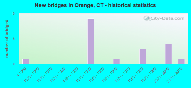
- New bridges - historical statistics
- 1Before 1900
- 91940-1949
- 11960-1969
- 31980-1989
- 42000-2009
- 12010-2019

- Reconstructed bridges - Historical Statistics
- 11940-1949
- 01950-1959
- 01960-1969
- 01970-1979
- 11980-1989
- 31990-1999


- Bridge Condition - Deck
- 12.5%Very good
- 75.0%Good
- 12.5%Satisfactory

- Bridge Condition - Superstructure
- 10.0%Very good
- 40.0%Good
- 40.0%Satisfactory
- 10.0%Fair

- Bridge Condition - Substructure
- 11.1%Very good
- 44.4%Good
- 44.4%Satisfactory

- Bridge Condition - Channel
- 10.0%Good
- 70.0%Satisfactory
- 20.0%Fair
Find on map >> Show street view
Structure Number: 154, Location: 0.8 MI S OF US1 (Lat: 41.253014, Lng: -72.999978), Route carried "on" structure: City street , Year Built: 2001, Status: Open, Structure Length: 9.08m (29.79ft), Average Daily Traffic: 14,713 (year 2019), Truck Traffic: 3%, Average Future Daily Traffic: 21,862 (year 2039), Design Load: HS 20, Features Intersected: I-95 & I-95 RAMP 352, Facility Carried by Structure: MARSH HILL ROAD
Minimum Vertical Clearance: 30+ m (98+ ft), Kilometerpoint: 0.257, Lanes on structure: 6, Lanes under structure: 7, Owner: State Highway Agency, Approaching Roadway Width: 22.9m (75.1ft), Skew: 3 degrees, Material/Design: Steel continuous, Design/Construction: Stringer/Multi-beam, Number Of Spans In Main Unit: 2, Length of Maximum Span: 50.9m (167.0ft), Curb or Sidewalk Widths: Left: 1.8m (5.9ft), Right: 1.8m (5.9ft), Curb-To-Curb Width: 22.8m (74.8ft), Out-to-Out Width: 27.2m (89.2ft)
Condition: Deck: Good, Superstructure: Good, Substructure: Satisfactory, Inventory Rating: 65.6 metric tons, Method Used To Determine Inventory Rating: Load Factor (LF), Structural Evaluation: Equal to present minimum criteria, Deck Geometry: Meets minimum limits, Underclear: Equal to present minimum criteria, Approach Roadway Alignment: Somewhat better than minimum adequacy, Designated Inspection Frequency: Every 24 months, Inspection Date: Febuary 2020, Deck Structure Type: Concrete Cast-file-Place, Wearing Surface/Protective System: Wearing Surface: Bituminous, Membrane: Built-up, Deck Protection: Epoxy Coated Reinforcing
Find on map >> Show street view
Structure Number: 764, Location: 3.7 MI N. OF ROUTE 110 (Lat: 41.276686, Lng: -73.051122), Route carried "on" structure: City street , Year Built: 1941, Year Reconstructed: 1990, Status: Open, Structure Length: 4.30m (14.11ft), Average Daily Traffic: 7,953 (year 2022), Truck Traffic: 4%, Average Future Daily Traffic: 11,817 (year 2042), Design Load: HS 20, Features Intersected: ROUTE 15, Facility Carried by Structure: DERBY MILFORD ROAD
Minimum Vertical Clearance: 30+ m (98+ ft), Kilometerpoint: 1.175, Lanes on structure: 2, Lanes under structure: 4, Owner: State Highway Agency, Approaching Roadway Width: 9.1m (29.9ft), Skew: 4 degrees, Material/Design: Steel continuous, Design/Construction: Frame, Number Of Spans In Main Unit: 2, Length of Maximum Span: 19.5m (64.0ft), Curb or Sidewalk Widths: Left: 0.2m (0.7ft), Right: 0.2m (0.7ft), Curb-To-Curb Width: 9.1m (29.9ft), Out-to-Out Width: 10.7m (35.1ft)
Condition: Deck: Good, Superstructure: Satisfactory, Substructure: Good, Inventory Rating: 70.5 metric tons, Method Used To Determine Inventory Rating: No rating analysis performed, Structural Evaluation: Equal to present minimum criteria, Deck Geometry: High priority of corrective action, Underclear: High priority of corrective action, Approach Roadway Alignment: Equal to present minimum criteria, Designated Inspection Frequency: Every 24 months, Inspection Date: October 2021, Deck Structure Type: Concrete Cast-file-Place, Wearing Surface/Protective System: Wearing Surface: Bituminous, Membrane: Preformed Fabric, Deck Protection: Epoxy Coated Reinforcing
Find on map >> Show street view
Structure Number: 765, Location: 1.3 MI S OF ROUTE 34 (Lat: 41.287869, Lng: -73.041175), Route carried "on" structure: State highway 121, Year Built: 1941, Year Reconstructed: 1990, Status: Open, Structure Length: 4.94m (16.21ft), Average Daily Traffic: 10,700 (year 2015), Truck Traffic: 5%, Average Future Daily Traffic: 15,899 (year 2035), Design Load: HS 20, Features Intersected: ROUTE 15
Minimum Vertical Clearance: 30+ m (98+ ft), Kilometerpoint: 6.470, Lanes on structure: 2, Lanes under structure: 4, Owner: State Highway Agency, Approaching Roadway Width: 13.7m (44.9ft), Skew: 5 degrees, Material/Design: Concrete, Design/Construction: Tee Beam, Number Of Spans In Main Unit: 2, Length of Maximum Span: 22.3m (73.2ft), Curb-To-Curb Width: 13.7m (44.9ft), Out-to-Out Width: 15.7m (51.5ft)
Condition: Deck: Satisfactory, Superstructure: Satisfactory, Substructure: Satisfactory, Operating Rating: 56.2 metric tons, Method Used To Determine Operating Rating: Load Factor (LF), Inventory Rating: 33.6 metric tons, Method Used To Determine Inventory Rating: Load Factor (LF), Structural Evaluation: Equal to present minimum criteria, Deck Geometry: Superior to present desirable criteria, Underclear: High priority of corrective action, Approach Roadway Alignment: Equal to present minimum criteria, Designated Inspection Frequency: Every 24 months, Inspection Date: October 2021, Deck Structure Type: Concrete Cast-file-Place, Wearing Surface/Protective System: Wearing Surface: Bituminous, Membrane: Preformed Fabric
Find on map >> Show street view
Structure Number: 766, Location: ROUTE 15 EXIT 57/58 (Lat: 41.306153, Lng: -73.033800), Route carried "on" structure: State highway 34, Year Built: 1941, Year Reconstructed: 1988, Status: Open, Structure Length: 3.08m (10.10ft), Average Daily Traffic: 34,700 (year 2015), Truck Traffic: 6%, Average Future Daily Traffic: 51,561 (year 2035), Features Intersected: ROUTE 15
Minimum Vertical Clearance: 30+ m (98+ ft), Kilometerpoint: 27.922, Lanes on structure: 4, Lanes under structure: 4, Base Highway Network: Yes, Owner: State Highway Agency, Approaching Roadway Width: 19.2m (63.0ft), Skew: 23 degrees, Material/Design: Concrete, Design/Construction: Arch - Deck, Number Of Spans In Main Unit: 2, Length of Maximum Span: 14.0m (45.9ft), Curb-To-Curb Width: 19.3m (63.3ft), Out-to-Out Width: 21.1m (69.2ft)
Condition: Superstructure: Satisfactory, Operating Rating: 52.6 metric tons, Method Used To Determine Operating Rating: Field evaluation and documented engineering judgment, Inventory Rating: 30.8 metric tons, Method Used To Determine Inventory Rating: Field evaluation and documented engineering judgment, Structural Evaluation: Equal to present minimum criteria, Deck Geometry: Equal to present minimum criteria, Underclear: High priority of corrective action, Approach Roadway Alignment: Equal to present desirable criteria, Designated Inspection Frequency: Every 24 months, Inspection Date: November 2021, Wearing Surface/Protective System: Wearing Surface: Bituminous
Find on map >> Show street view
Structure Number: 767, Location: 0.2 MILES NORTH ROUTE 34 (Lat: 41.309231, Lng: -73.032158), Route carried "on" structure: State highway 15, Year Built: 1949, Year Reconstructed: 1990, Status: Posted for load-capacity, Structure Length: 1.59m (5.22ft), Average Daily Traffic: 71,400 (year 2015), Average Future Daily Traffic: 106,093 (year 2035), Design Load: HS 20, Features Intersected: WEPAWAUG RIVER
Minimum Vertical Clearance: 30+ m (98+ ft), Kilometerpoint: 69.282, Lanes on structure: 4, Base Highway Network: Yes, Owner: State Highway Agency, Approaching Roadway Width: 19.8m (65.0ft), Skew: 24 degrees, Material/Design: Steel, Design/Construction: Stringer/Multi-beam, Number Of Spans In Main Unit: 1, Length of Maximum Span: 14.0m (45.9ft), Curb-To-Curb Width: 25.7m (84.3ft), Out-to-Out Width: 27.3m (89.6ft)
Condition: Deck: Good, Superstructure: Good, Substructure: Satisfactory, Channel: Fair, Operating Rating: 72.3 metric tons, Method Used To Determine Operating Rating: Load and Resistance Factor Rating (LRFR) rating reported by rating factor(RF) method using HL-93 loadings, Inventory Rating: 55.4 metric tons, Method Used To Determine Inventory Rating: Load and Resistance Factor Rating (LRFR) rating reported by rating factor(RF) method using HL-93 loadings, Structural Evaluation: Equal to present minimum criteria, Deck Geometry: Superior to present desirable criteria, Waterway Adequacy: Equal to present desirable criteria, Approach Roadway Alignment: Equal to present desirable criteria, Designated Inspection Frequency: Every 24 months, Inspection Date: March 2021, Deck Structure Type: Concrete Cast-file-Place, Wearing Surface/Protective System: Wearing Surface: Bituminous, Membrane: Preformed Fabric, Deck Protection: Epoxy Coated Reinforcing
Find on map >> Show street view
Structure Number: 948, Location: 0.3 MI E OF ROUTE 15 (Lat: 41.303878, Lng: -73.030258), Route carried "on" structure: State highway 34, Year Built: 1855, Year Reconstructed: 1940, Status: Open, Structure Length: 0.73m (2.40ft), Average Daily Traffic: 34,600 (year 2015), Truck Traffic: 4%, Average Future Daily Traffic: 51,412 (year 2035), Features Intersected: WEPAWAUG RIVER
Minimum Vertical Clearance: 30+ m (98+ ft), Kilometerpoint: 28.341, Lanes on structure: 4, Base Highway Network: Yes, Owner: State Highway Agency, Approaching Roadway Width: 17.4m (57.1ft), Skew: 30 degrees, Material/Design: Masonry, Design/Construction: Arch - Deck, Number Of Spans In Main Unit: 1, Length of Maximum Span: 7.3m (24.0ft), Curb-To-Curb Width: 17.4m (57.1ft), Out-to-Out Width: 22.6m (74.1ft)
Condition: Superstructure: Good, Substructure: Satisfactory, Channel: Satisfactory, Structural Evaluation: Equal to present minimum criteria, Deck Geometry: Somewhat better than minimum adequacy, Waterway Adequacy: Equal to present minimum criteria, Approach Roadway Alignment: Equal to present desirable criteria, Designated Inspection Frequency: Every 24 months, Inspection Date: April 2020
Find on map >> Show street view
Structure Number: 4098, Location: 0.1 MI E OF ROUTE 121 (Lat: 41.285931, Lng: -73.039811), Route carried "on" structure: City street , Year Built: 1941, Status: Open, Structure Length: 1.31m (4.30ft), Average Daily Traffic: 6,400 (year 2012), Truck Traffic: 4%, Average Future Daily Traffic: 9,510 (year 2032), Design Load: HS 20, Features Intersected: WEPAWAUG RIVER, Facility Carried by Structure: OLD GRASSY HILL
Minimum Vertical Clearance: 30+ m (98+ ft), Kilometerpoint: 0.161, Lanes on structure: 2, Owner: Town or Township Highway Agency, Approaching Roadway Width: 6.1m (20.0ft), Material/Design: Concrete, Design/Construction: Tee Beam, Number Of Spans In Main Unit: 1, Length of Maximum Span: 12.2m (40.0ft), Curb or Sidewalk Widths: Left: 0.2m (0.7ft), Right: 0.2m (0.7ft), Curb-To-Curb Width: 8.5m (27.9ft), Out-to-Out Width: 10.1m (33.1ft)
Condition: Deck: Good, Superstructure: Fair, Substructure: Good, Channel: Satisfactory, Operating Rating: 65.3 metric tons, Method Used To Determine Operating Rating: Load Factor (LF), Inventory Rating: 39.2 metric tons, Method Used To Determine Inventory Rating: Load Factor (LF), Structural Evaluation: Somewhat better than minimum adequacy, Deck Geometry: High priority of replacement, Waterway Adequacy: Better than present minimum criteria, Approach Roadway Alignment: Equal to present desirable criteria, Designated Inspection Frequency: Every 24 months, Inspection Date: April 2021, Deck Structure Type: Concrete Cast-file-Place, Wearing Surface/Protective System: Wearing Surface: Bituminous
Find on map >> Show street view
Structure Number: 4099, Location: 50 FT N OF ROUTE 121 (Lat: 41.266347, Lng: -73.050592), Route carried "on" structure: City street , Year Built: 2019, Status: Open, Structure Length: 2.72m (8.92ft), Average Daily Traffic: 7,200 (year 2012), Truck Traffic: 4%, Average Future Daily Traffic: 10,698 (year 2032), Design Load: HL 93, Features Intersected: WEPAWAUG RIVER, Facility Carried by Structure: DERBY-MILFORD ROAD
Minimum Vertical Clearance: 30+ m (98+ ft), Kilometerpoint: 0.051, Lanes on structure: 2, Owner: Town or Township Highway Agency, Approaching Roadway Width: 9.8m (32.2ft), Skew: 4 degrees, Material/Design: Prestressed concrete, Design/Construction: Box Beam or Girders - Multiple, Number Of Spans In Main Unit: 1, Length of Maximum Span: 25.9m (85.0ft), Curb-To-Curb Width: 9.8m (32.2ft), Out-to-Out Width: 10.8m (35.4ft)
Condition: Deck: Very good, Superstructure: Very good, Substructure: Very good, Channel: Good, Operating Rating: 97.2 metric tons, Method Used To Determine Operating Rating: Load and Resistance Factor Rating (LRFR) rating reported by rating factor(RF) method using HL-93 loadings, Inventory Rating: 92.0 metric tons, Method Used To Determine Inventory Rating: Load and Resistance Factor Rating (LRFR) rating reported by rating factor(RF) method using HL-93 loadings, Structural Evaluation: Equal to present desirable criteria, Deck Geometry: Meets minimum limits, Waterway Adequacy: Equal to present minimum criteria, Approach Roadway Alignment: Better than present minimum criteria, Designated Inspection Frequency: Every 24 months, Inspection Date: May 2021, Total Project Cost: $3,152,000 ( Estimate for 2016), Deck Structure Type: Concrete Cast-file-Place, Wearing Surface/Protective System: Wearing Surface: Bituminous, Membrane: Other
Find on map >> Show street view
Structure Number: 41, Location: 0.1 MI S OF ROUTE 152 (Lat: 41.294736, Lng: -73.024725), Route carried "on" structure: City street , Year Built: 1946, Status: Open, Structure Length: 0.88m (2.89ft), Average Daily Traffic: 2,200 (year 2015), Truck Traffic: 4%, Average Future Daily Traffic: 3,269 (year 2035), Design Load: H 20, Features Intersected: RACE BROOK, Facility Carried by Structure: LAMBERT ROAD
Minimum Vertical Clearance: 30+ m (98+ ft), Kilometerpoint: 4.474, Lanes on structure: 2, Owner: Town or Township Highway Agency, Approaching Roadway Width: 6.4m (21.0ft), Skew: 4 degrees, Material/Design: Concrete, Design/Construction: Slab, Number Of Spans In Main Unit: 1, Length of Maximum Span: 7.9m (25.9ft), Curb-To-Curb Width: 6.4m (21.0ft), Out-to-Out Width: 7.4m (24.3ft)
Condition: Deck: Good, Superstructure: Good, Substructure: Good, Channel: Satisfactory, Operating Rating: 27.5 metric tons, Method Used To Determine Operating Rating: Load and Resistance Factor Rating (LRFR) rating reported by rating factor(RF) method using HL-93 loadings, Inventory Rating: 21.4 metric tons, Method Used To Determine Inventory Rating: Load and Resistance Factor Rating (LRFR) rating reported by rating factor(RF) method using HL-93 loadings, Structural Evaluation: Somewhat better than minimum adequacy, Deck Geometry: High priority of replacement, Waterway Adequacy: Better than present minimum criteria, Approach Roadway Alignment: Equal to present desirable criteria, Designated Inspection Frequency: Every 24 months, Inspection Date: May 2021, Deck Structure Type: Concrete Cast-file-Place, Wearing Surface/Protective System: Wearing Surface: Bituminous
Find on map >> Show street view
Structure Number: 4923, Location: 0.2 MI W OF ROUTE 121 (Lat: 41.277003, Lng: -73.045925), Route carried "on" structure: City street , Year Built: 1965, Status: Open, Structure Length: 1.59m (5.22ft), Average Daily Traffic: 851 (year 2019), Truck Traffic: 3%, Average Future Daily Traffic: 1,265 (year 2039), Features Intersected: WEPAWAUG RIVER, Facility Carried by Structure: PRUDDEN LANE
Minimum Vertical Clearance: 30+ m (98+ ft), Kilometerpoint: 0.612, Lanes on structure: 2, Owner: Town or Township Highway Agency, Approaching Roadway Width: 8.8m (28.9ft), Skew: 3 degrees, Material/Design: Prestressed concrete, Design/Construction: Box Beam or Girders - Multiple, Number Of Spans In Main Unit: 1, Length of Maximum Span: 14.9m (48.9ft), Curb or Sidewalk Widths: Left: 0.2m (0.7ft), Right: 0.2m (0.7ft), Curb-To-Curb Width: 8.7m (28.5ft), Out-to-Out Width: 9.1m (29.9ft)
Condition: Deck: Good, Superstructure: Satisfactory, Substructure: Good, Channel: Satisfactory, Operating Rating: 42.6 metric tons, Method Used To Determine Operating Rating: Field evaluation and documented engineering judgment, Inventory Rating: 32.7 metric tons, Method Used To Determine Inventory Rating: Field evaluation and documented engineering judgment, Structural Evaluation: Equal to present minimum criteria, Deck Geometry: Somewhat better than minimum adequacy, Waterway Adequacy: Better than present minimum criteria, Approach Roadway Alignment: Equal to present desirable criteria, Designated Inspection Frequency: Every 24 months, Inspection Date: April 2021, Deck Structure Type: Other, Wearing Surface/Protective System: Wearing Surface: Bituminous
Find on map >> Show street view
Structure Number: 5252, Location: 0.7 MI S OF ROUTE 34 (Lat: 41.291589, Lng: -73.027425), Route carried "on" structure: State highway 152, Year Built: 1983, Status: Open, Structure Length: 0.67m (2.20ft), Average Daily Traffic: 3,500 (year 2015), Truck Traffic: 4%, Average Future Daily Traffic: 5,201 (year 2035), Design Load: HS 20, Features Intersected: RACE BROOK
Minimum Vertical Clearance: 30+ m (98+ ft), Kilometerpoint: 4.136, Lanes on structure: 2, Owner: State Highway Agency, Approaching Roadway Width: 8.5m (27.9ft), Material/Design: Concrete, Design/Construction: Culvert, Number Of Spans In Main Unit: 2, Length of Maximum Span: 3.0m (9.8ft), Curb-To-Curb Width: 8.5m (27.9ft), Out-to-Out Width: 11.6m (38.1ft)
Condition: Channel: Fair, Culverts: Good, Operating Rating: 53.8 metric tons, Method Used To Determine Operating Rating: Load and Resistance Factor Rating (LRFR) rating reported by rating factor(RF) method using HL-93 loadings, Inventory Rating: 41.5 metric tons, Method Used To Determine Inventory Rating: Load and Resistance Factor Rating (LRFR) rating reported by rating factor(RF) method using HL-93 loadings, Structural Evaluation: Better than present minimum criteria, Deck Geometry: Meets minimum limits, Waterway Adequacy: Equal to present desirable criteria, Approach Roadway Alignment: Equal to present desirable criteria, Designated Inspection Frequency: Every 24 months, Inspection Date: March 2020, Deck Structure Type: Other, Wearing Surface/Protective System: Wearing Surface: Bituminous, Membrane: Built-up
Find on map >> Show street view
Structure Number: 5255, Location: 0.3 MI N OF ROUTE 152 (Lat: 41.292097, Lng: -73.030169), Route carried "on" structure: City street , Year Built: 1983, Status: Open, Structure Length: 0.79m (2.59ft), Average Daily Traffic: 2,227 (year 2019), Truck Traffic: 2%, Average Future Daily Traffic: 3,309 (year 2039), Features Intersected: RACE BROOK, Facility Carried by Structure: MAPLEDALE ROAD
Minimum Vertical Clearance: 30+ m (98+ ft), Kilometerpoint: 0.467, Lanes on structure: 2, Owner: Town or Township Highway Agency, Approaching Roadway Width: 6.1m (20.0ft), Skew: 1 degrees, Material/Design: Concrete, Design/Construction: Culvert, Number Of Spans In Main Unit: 2, Length of Maximum Span: 3.7m (12.1ft), Curb-To-Curb Width: 8.6m (28.2ft), Out-to-Out Width: 11.0m (36.1ft)
Condition: Channel: Satisfactory, Culverts: Good, Operating Rating: 52.6 metric tons, Method Used To Determine Operating Rating: Field evaluation and documented engineering judgment, Inventory Rating: 30.8 metric tons, Method Used To Determine Inventory Rating: Field evaluation and documented engineering judgment, Structural Evaluation: Better than present minimum criteria, Deck Geometry: Meets minimum limits, Waterway Adequacy: Equal to present desirable criteria, Approach Roadway Alignment: Equal to present desirable criteria, Designated Inspection Frequency: Every 24 months, Inspection Date: April 2021, Deck Structure Type: Other, Wearing Surface/Protective System: Wearing Surface: Bituminous, Membrane: Built-up
Find on map >> Show street view
Structure Number: 531, Location: 0.2 MI S OF ROUTE 15 (Lat: 41.283942, Lng: -73.040489), Route carried "on" structure: State highway 121, Year Built: 1984, Status: Open, Structure Length: 1.40m (4.59ft), Average Daily Traffic: 5,800 (year 2015), Truck Traffic: 4%, Average Future Daily Traffic: 8,618 (year 2035), Design Load: HS 20, Features Intersected: WEPAWAUG RIVER
Minimum Vertical Clearance: 30+ m (98+ ft), Kilometerpoint: 6.051, Lanes on structure: 2, Owner: State Highway Agency, Approaching Roadway Width: 9.1m (29.9ft), Material/Design: Concrete, Design/Construction: Culvert, Number Of Spans In Main Unit: 3, Length of Maximum Span: 4.3m (14.1ft), Curb-To-Curb Width: 9.0m (29.5ft), Out-to-Out Width: 14.6m (47.9ft)
Condition: Channel: Satisfactory, Culverts: Good, Operating Rating: 51.5 metric tons, Method Used To Determine Operating Rating: Load and Resistance Factor Rating (LRFR) rating reported by rating factor(RF) method using HL-93 loadings, Inventory Rating: 39.9 metric tons, Method Used To Determine Inventory Rating: Load and Resistance Factor Rating (LRFR) rating reported by rating factor(RF) method using HL-93 loadings, Structural Evaluation: Better than present minimum criteria, Deck Geometry: High priority of replacement, Waterway Adequacy: Equal to present desirable criteria, Approach Roadway Alignment: Equal to present desirable criteria, Designated Inspection Frequency: Every 24 months, Inspection Date: June 2021, Deck Structure Type: Other, Wearing Surface/Protective System: Wearing Surface: Bituminous, Membrane: Built-up
Find on map >> Show street view
Structure Number: 6758, Location: 0.2 MI W OF ROUTE 114 (Lat: 41.267494, Lng: -73.003517), Route carried "on" structure: City street , Year Built: 2000, Status: Open, Structure Length: 0.76m (2.49ft), Average Daily Traffic: 5,400 (year 2011), Truck Traffic: 5%, Average Future Daily Traffic: 8,024 (year 2031), Features Intersected: SILVER BROOK, Facility Carried by Structure: OLD TAVERN ROAD
Minimum Vertical Clearance: 30+ m (98+ ft), Kilometerpoint: 1.738, Lanes on structure: 2, Owner: Town or Township Highway Agency, Approaching Roadway Width: 9.1m (29.9ft), Skew: 1 degrees, Material/Design: Concrete, Design/Construction: Culvert, Number Of Spans In Main Unit: 1, Length of Maximum Span: 7.6m (24.9ft), Curb-To-Curb Width: 9.1m (29.9ft), Out-to-Out Width: 11.8m (38.7ft)
Condition: Channel: Satisfactory, Culverts: Good, Operating Rating: 42.6 metric tons, Method Used To Determine Operating Rating: Field evaluation and documented engineering judgment, Inventory Rating: 32.7 metric tons, Method Used To Determine Inventory Rating: Field evaluation and documented engineering judgment, Structural Evaluation: Better than present minimum criteria, Deck Geometry: High priority of corrective action, Waterway Adequacy: Better than present minimum criteria, Approach Roadway Alignment: Equal to present desirable criteria, Designated Inspection Frequency: Every 48 months, Inspection Date: May 2019, Deck Structure Type: Other, Wearing Surface/Protective System: Wearing Surface: Bituminous, Membrane: Built-up, Deck Protection: Epoxy Coated Reinforcing
Find on map >> Show street view
Structure Number: 154, Location: 0.8 MI S OF US1 (Lat: 41.253014, Lng: -72.999978), Route carried "under" structure: Ramp Interstate 95, Year Built: 2001, Structure Length: 0. m, Average Daily Traffic: 3,966 (year 2019), Truck Traffic: 9%, Features Intersected: I-95 & I-95 RAMP 352, Facility Carried by Structure: MARSH HILL ROAD
Minimum Vertical Clearance: 6.30m (20.67ft), Kilometerpoint: 0.000, Lanes on structure: 6, Lanes under structure: 1, Material/Design: Steel continuous, Design/Construction: Stringer/Multi-beam, Length of Maximum Span: 50.9m (167.0ft)
Find on map >> Show street view
Structure Number: 154, Location: 0.8 MI S OF US1 (Lat: 41.253014, Lng: -72.999978), Route carried "under" structure: Interstate 95, Year Built: 2001, Structure Length: 0. m, Average Daily Traffic: 108,400 (year 2017), Truck Traffic: 9%, Features Intersected: I-95 & I-95 RAMP 352, Facility Carried by Structure: MARSH HILL ROAD
Minimum Vertical Clearance: 6.02m (19.75ft), Kilometerpoint: 67.271, Lanes on structure: 6, Lanes under structure: 7, Material/Design: Steel continuous, Design/Construction: Stringer/Multi-beam, Length of Maximum Span: 50.9m (167.0ft)
Find on map >> Show street view
Structure Number: 764, Location: 3.7 MI N. OF ROUTE 110 (Lat: 41.276686, Lng: -73.051122), Route carried "under" structure: State highway 15, Year Built: 1941, Structure Length: 0. m, Average Daily Traffic: 67,900 (year 2019), Truck Traffic: 1%, Features Intersected: ROUTE 15, Facility Carried by Structure: DERBY MILFORD ROAD
Minimum Vertical Clearance: 4.34m (14.24ft), Kilometerpoint: 65.307, Lanes on structure: 2, Lanes under structure: 4, Material/Design: Steel continuous, Design/Construction: Frame, Length of Maximum Span: 19.5m (64.0ft)
Find on map >> Show street view
Structure Number: 765, Location: 1.3 MI S OF ROUTE 34 (Lat: 41.287869, Lng: -73.041175), Route carried "under" structure: State highway 15, Year Built: 1941, Structure Length: 0. m, Average Daily Traffic: 67,400 (year 2019), Truck Traffic: 1%, Features Intersected: ROUTE 15, Facility Carried by Structure: ROUTE 121
Minimum Vertical Clearance: 4.24m (13.91ft), Kilometerpoint: 66.772, Lanes on structure: 2, Lanes under structure: 4, Material/Design: Concrete, Design/Construction: Tee Beam, Length of Maximum Span: 22.3m (73.2ft)
Find on map >> Show street view
Structure Number: 766, Location: ROUTE 15 EXIT 57/58 (Lat: 41.306153, Lng: -73.033800), Route carried "under" structure: State highway 15, Year Built: 1941, Structure Length: 0. m, Average Daily Traffic: 70,100 (year 2019), Truck Traffic: 1%, Features Intersected: ROUTE 15, Facility Carried by Structure: ROUTE 34
Minimum Vertical Clearance: 5.26m (17.26ft), Kilometerpoint: 68.928, Lanes on structure: 4, Lanes under structure: 4, Material/Design: Concrete, Design/Construction: Arch - Deck, Length of Maximum Span: 14.0m (45.9ft)