Bridge Statistics for Orange Lake, New York (NY)
Condition, Traffic, Stress, Structural Evaluation, Project Costs
- National Bridge Inventory (NBI) Statistics
- 28Number of bridges
- 285ft / 86.6mTotal length
- $84,088,000Total costs
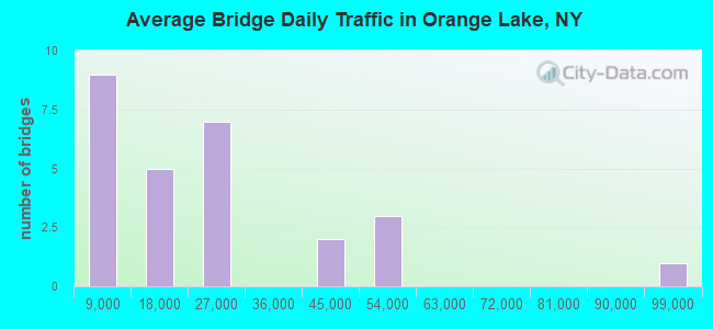
- 572,445Total average daily traffic
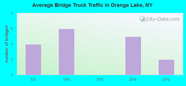
- 35,305Total average daily truck traffic
- National Bridge Inventory (NBI) Registered Bridges for Orange Lake
- No street view available for this location
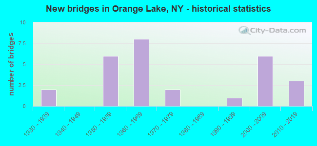
- New bridges - historical statistics
- 21930-1939
- 61950-1959
- 81960-1969
- 21970-1979
- 11990-1999
- 62000-2009
- 32010-2019
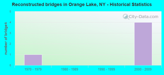
- Reconstructed bridges - Historical Statistics
- 11970-1979
- 01980-1989
- 01990-1999
- 42000-2009
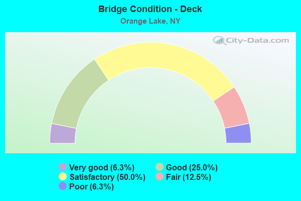
- Bridge Condition - Deck
- 6.3%Very good
- 25.0%Good
- 50.0%Satisfactory
- 12.5%Fair
- 6.3%Poor

- Bridge Condition - Superstructure
- 18.8%Excellent
- 18.8%Very good
- 18.8%Good
- 12.5%Satisfactory
- 31.3%Fair
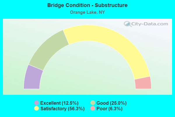
- Bridge Condition - Substructure
- 12.5%Excellent
- 25.0%Good
- 56.3%Satisfactory
- 6.3%Poor
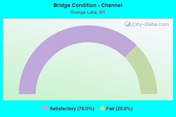
- Bridge Condition - Channel
- 75.0%Satisfactory
- 25.0%Fair
Find on map >> Show street view
Structure Number: 101452, Location: JCT RTS 17K+I87 (Lat: 41.505856, Lng: -74.075592), Route carried "on" structure: State highway 17K, Year Built: 1954, Status: Open, Structure Length: 6.58m (21.59ft), Average Daily Traffic: 16,200 (year 2019), Truck Traffic: 6%, Average Future Daily Traffic: 16,276 (year 2040), Design Load: HS 20+Mod, Features Intersected: 87IX SB, RTE I87
Minimum Vertical Clearance: 30+ m (98+ ft), Kilometerpoint: 31.520, Lanes on structure: 2, Lanes under structure: 6, Base Highway Network: Yes, Owner: State Toll Authority, Approaching Roadway Width: 12.2m (40.0ft), Material/Design: Steel continuous, Design/Construction: Stringer/Multi-beam, Number Of Spans In Main Unit: 4, Length of Maximum Span: 20.1m (65.9ft), Curb-To-Curb Width: 11.9m (39.0ft), Out-to-Out Width: 13.1m (43.0ft)
Condition: Deck: Satisfactory, Superstructure: Fair, Substructure: Satisfactory, Operating Rating: 37.2 metric tons, Method Used To Determine Operating Rating: Load Factor (LF), Inventory Rating: 21.8 metric tons, Method Used To Determine Inventory Rating: Load Factor (LF), Structural Evaluation: Somewhat better than minimum adequacy, Deck Geometry: Somewhat better than minimum adequacy, Underclear: High priority of corrective action, Approach Roadway Alignment: Equal to present desirable criteria, Length Of Structure Improvement: 6.58m (21.59ft), Designated Inspection Frequency: Every 24 months, Inspection Date: September 2021, Bridge Improvement Cost: $3,429,000, Roadway Improvement Cost: $2,008,000, Total Project Cost: $5,436,000 ( Estimate for 2021), Deck Structure Type: Concrete Cast-file-Place, Wearing Surface/Protective System: Wearing Surface: Bituminous, Membrane: Other
Find on map >> Show street view
Structure Number: 102674, Location: 2.6 MI E JCT RTS 52+208 (Lat: 41.554139, Lng: -74.140636), Route carried "on" structure: State highway 52, Year Built: 1931, Year Reconstructed: 1970, Status: Open, Structure Length: 0.79m (2.59ft), Average Daily Traffic: 6,719 (year 2020), Truck Traffic: 6%, Average Future Daily Traffic: 8,162 (year 2040), Design Load: H 20, Features Intersected: TIN BROOK
Minimum Vertical Clearance: 30+ m (98+ ft), Kilometerpoint: 16.637, Lanes on structure: 2, Base Highway Network: Yes, Owner: State Highway Agency, Approaching Roadway Width: 9.1m (29.9ft), Skew: 1 degrees, Material/Design: Concrete, Design/Construction: Slab, Number Of Spans In Main Unit: 1, Length of Maximum Span: 7.3m (24.0ft), Curb-To-Curb Width: 8.3m (27.2ft), Out-to-Out Width: 8.9m (29.2ft)
Condition: Deck: Fair, Superstructure: Fair, Substructure: Satisfactory, Channel: Satisfactory, Operating Rating: 68.0 metric tons, Method Used To Determine Operating Rating: Load Factor (LF), Inventory Rating: 40.8 metric tons, Method Used To Determine Inventory Rating: Load Factor (LF), Structural Evaluation: Somewhat better than minimum adequacy, Deck Geometry: High priority of replacement, Waterway Adequacy: Superior to present desirable criteria, Approach Roadway Alignment: Equal to present desirable criteria, Length Of Structure Improvement: 0.79m (2.59ft), Designated Inspection Frequency: Every 24 months, Inspection Date: August 2021, Bridge Improvement Cost: $320,000, Roadway Improvement Cost: $188,000, Total Project Cost: $508,000 ( Estimate for 2021), Wearing Surface/Protective System: Wearing Surface: Bituminous
Find on map >> Show street view
Structure Number: 102675, Location: 2.7 MI E JCT RTS 52+208 (Lat: 41.553753, Lng: -74.137731), Route carried "on" structure: State highway 52, Year Built: 2016, Status: Open, Structure Length: 1.46m (4.79ft), Average Daily Traffic: 6,719 (year 2020), Truck Traffic: 6%, Average Future Daily Traffic: 8,162 (year 2040), Design Load: HL 93, Features Intersected: TIN BROOK
Minimum Vertical Clearance: 30+ m (98+ ft), Kilometerpoint: 16.701, Lanes on structure: 2, Base Highway Network: Yes, Owner: State Highway Agency, Approaching Roadway Width: 10.4m (34.1ft), Skew: 1 degrees, Material/Design: Prestressed concrete, Design/Construction: Box Beam or Girders - Multiple, Number Of Spans In Main Unit: 1, Length of Maximum Span: 14.3m (46.9ft), Curb-To-Curb Width: 10.4m (34.1ft), Out-to-Out Width: 11.4m (37.4ft)
Condition: Deck: Good, Superstructure: Very good, Substructure: Excellent, Channel: Satisfactory, Operating Rating: 52.6 metric tons, Method Used To Determine Operating Rating: Load Factor (LF), Inventory Rating: 24.5 metric tons, Method Used To Determine Inventory Rating: Load Factor (LF), Structural Evaluation: Equal to present minimum criteria, Deck Geometry: Meets minimum limits, Waterway Adequacy: Equal to present minimum criteria, Approach Roadway Alignment: Equal to present desirable criteria, Length Of Structure Improvement: 1.46m (4.79ft), Designated Inspection Frequency: Every 24 months, Inspection Date: November 2020, Bridge Improvement Cost: $420,000, Roadway Improvement Cost: $246,000, Total Project Cost: $666,000 ( Estimate for 2021), Wearing Surface/Protective System: Wearing Surface: Integral Concrete
Find on map >> Show street view
Structure Number: 104526, Location: 1.4 MI W JCT RTS 300+I87 (Lat: 41.576314, Lng: -74.102586), Route carried "on" structure: State highway 300, Year Built: 1938, Status: Open, Structure Length: 1.13m (3.71ft), Average Daily Traffic: 5,526 (year 2020), Truck Traffic: 6%, Average Future Daily Traffic: 6,712 (year 2040), Features Intersected: BUSHFIELD CREEK
Minimum Vertical Clearance: 30+ m (98+ ft), Kilometerpoint: 3.813, Lanes on structure: 2, Base Highway Network: Yes, Owner: State Highway Agency, Approaching Roadway Width: 8.5m (27.9ft), Skew: 3 degrees, Material/Design: Steel, Design/Construction: Stringer/Multi-beam, Number Of Spans In Main Unit: 1, Length of Maximum Span: 10.6m (34.8ft), Curb or Sidewalk Widths: Left: 1.4m (4.6ft), Right: 0.0m, Curb-To-Curb Width: 8.1m (26.6ft), Out-to-Out Width: 10.5m (34.4ft)
Condition: Deck: Fair, Superstructure: Satisfactory, Substructure: Satisfactory, Channel: Satisfactory, Operating Rating: 68.0 metric tons, Method Used To Determine Operating Rating: Load Factor (LF), Inventory Rating: 40.8 metric tons, Method Used To Determine Inventory Rating: Load Factor (LF), Structural Evaluation: Equal to present minimum criteria, Deck Geometry: High priority of replacement, Waterway Adequacy: Meets minimum limits, Approach Roadway Alignment: Meets minimum limits, Length Of Structure Improvement: 1.12m (3.67ft), Designated Inspection Frequency: Every 24 months, Inspection Date: August 2021, Bridge Improvement Cost: $813,000, Roadway Improvement Cost: $476,000, Total Project Cost: $1,290,000 ( Estimate for 2021), Deck Structure Type: Concrete Cast-file-Place, Wearing Surface/Protective System: Wearing Surface: Bituminous
Find on map >> Show street view
Structure Number: 105268, Location: 2.8 MI E JCT RTS I84+208 (Lat: 41.513764, Lng: -74.157678), Route carried "on" structure: Other road , Year Built: 1968, Status: Open, Structure Length: 7.32m (24.02ft), Average Daily Traffic: 131 (year 2019), Truck Traffic: 6%, Average Future Daily Traffic: 183 (year 2039), Design Load: HS 20, Features Intersected: 84I 84I83011315 WB, RTE, Facility Carried by Structure: RIDGE ROAD
Minimum Vertical Clearance: 30+ m (98+ ft), Kilometerpoint: 1.352, Lanes on structure: 2, Lanes under structure: 4, Owner: State Highway Agency, Approaching Roadway Width: 9.8m (32.2ft), Material/Design: Steel, Design/Construction: Stringer/Multi-beam, Number Of Spans In Main Unit: 2, Length of Maximum Span: 36.2m (118.8ft), Curb or Sidewalk Widths: Left: 0.5m (1.6ft), Right: 0.5m (1.6ft), Curb-To-Curb Width: 8.5m (27.9ft), Out-to-Out Width: 10.0m (32.8ft)
Condition: Deck: Good, Superstructure: Very good, Substructure: Satisfactory, Operating Rating: 62.2 metric tons, Method Used To Determine Operating Rating: Load and Resistance Factor Rating (LRFR) rating reported by rating factor(RF) method using HL-93 loadings, Inventory Rating: 48.0 metric tons, Method Used To Determine Inventory Rating: Load and Resistance Factor Rating (LRFR) rating reported by rating factor(RF) method using HL-93 loadings, Structural Evaluation: Equal to present minimum criteria, Deck Geometry: Equal to present minimum criteria, Underclear: Somewhat better than minimum adequacy, Approach Roadway Alignment: Equal to present desirable criteria, Length Of Structure Improvement: 7.31m (23.98ft), Designated Inspection Frequency: Every 24 months, Inspection Date: March 2021, Bridge Improvement Cost: $2,910,000, Roadway Improvement Cost: $1,704,000, Total Project Cost: $4,614,000 ( Estimate for 2021), Deck Structure Type: Concrete Cast-file-Place, Wearing Surface/Protective System: Wearing Surface: Integral Concrete
Find on map >> Show street view
Structure Number: 105269, Location: 4.2 MI E JCT RTS I84+208 (Lat: 41.512422, Lng: -74.130364), Route carried "on" structure: Alternate State highway 747, Year Built: 2007, Status: Open, Structure Length: 6.74m (22.11ft), Average Daily Traffic: 10,992 (year 2017), Truck Traffic: 4%, Average Future Daily Traffic: 13,600 (year 2040), Design Load: HS 25 or greater, Features Intersected: 84I 84I83011329 WB, RTE
Minimum Vertical Clearance: 30+ m (98+ ft), Kilometerpoint: 3.894, Lanes on structure: 5, Lanes under structure: 5, Base Highway Network: Yes, Owner: State Highway Agency, Approaching Roadway Width: 24.1m (79.1ft), Skew: 20 degrees, Material/Design: Steel continuous, Design/Construction: Stringer/Multi-beam, Number Of Spans In Main Unit: 2, Length of Maximum Span: 32.9m (107.9ft), Curb-To-Curb Width: 24.0m (78.7ft), Out-to-Out Width: 24.9m (81.7ft)
Condition: Deck: Satisfactory, Superstructure: Very good, Substructure: Satisfactory, Operating Rating: 68.9 metric tons, Method Used To Determine Operating Rating: Load Factor (LF), Inventory Rating: 40.8 metric tons, Method Used To Determine Inventory Rating: Load Factor (LF), Structural Evaluation: Equal to present minimum criteria, Deck Geometry: Equal to present desirable criteria, Underclear: Equal to present minimum criteria, Approach Roadway Alignment: Equal to present desirable criteria, Length Of Structure Improvement: 6.73m (22.08ft), Designated Inspection Frequency: Every 24 months, Inspection Date: September 2020, Bridge Improvement Cost: $9,020,000, Roadway Improvement Cost: $5,282,000, Total Project Cost: $14,302,000 ( Estimate for 2021), Deck Structure Type: Concrete Cast-file-Place, Wearing Surface/Protective System: Wearing Surface: Integral Concrete, Deck Protection: Galvanized Reinforcing
Find on map >> Show street view
Structure Number: 1052701, Location: JCT RTS I84+17K (Lat: 41.520439, Lng: -74.110094), Route carried "on" structure: Interstate 84, Year Built: 1968, Year Reconstructed: 2006, Status: Open, Structure Length: 4.08m (13.39ft), Average Daily Traffic: 25,993 (year 2009), Truck Traffic: 20%, Design Load: HS 20, Features Intersected: RTE 17K
Minimum Vertical Clearance: 30+ m (98+ ft), Kilometerpoint: 54.819, Lanes on structure: 2, Lanes under structure: 5, Base Highway Network: Yes, Owner: State Highway Agency, Approaching Roadway Width: 12.2m (40.0ft), Material/Design: Steel, Design/Construction: Stringer/Multi-beam, Number Of Spans In Main Unit: 1, Length of Maximum Span: 39.0m (128.0ft), Curb-To-Curb Width: 11.9m (39.0ft), Out-to-Out Width: 13.0m (42.7ft)
Condition: Deck: Good, Superstructure: Fair, Substructure: Satisfactory, Operating Rating: 97.1 metric tons, Method Used To Determine Operating Rating: Load Factor (LF), Inventory Rating: 58.1 metric tons, Method Used To Determine Inventory Rating: Load Factor (LF), Structural Evaluation: Somewhat better than minimum adequacy, Deck Geometry: Equal to present minimum criteria, Underclear: Meets minimum limits, Approach Roadway Alignment: Equal to present desirable criteria, Length Of Structure Improvement: 4.08m (13.39ft), Designated Inspection Frequency: Every 24 months, Inspection Date: April 2021, Bridge Improvement Cost: $2,607,000, Roadway Improvement Cost: $1,526,000, Total Project Cost: $4,133,000 ( Estimate for 2021), Deck Structure Type: Concrete Cast-file-Place, Wearing Surface/Protective System: Wearing Surface: Monolithic Concrete
Find on map >> Show street view
Structure Number: 1052702, Location: JCT RTS I84+17K (Lat: 41.520169, Lng: -74.109758), Route carried "on" structure: Interstate 84, Year Built: 1968, Year Reconstructed: 2006, Status: Open, Structure Length: 4.08m (13.39ft), Average Daily Traffic: 24,708 (year 2019), Truck Traffic: 19%, Average Future Daily Traffic: 41,840 (year 2040), Design Load: HS 20, Features Intersected: RTE 17K
Minimum Vertical Clearance: 30+ m (98+ ft), Kilometerpoint: 54.883, Lanes on structure: 2, Lanes under structure: 5, Base Highway Network: Yes, Owner: State Highway Agency, Approaching Roadway Width: 12.2m (40.0ft), Material/Design: Steel, Design/Construction: Stringer/Multi-beam, Number Of Spans In Main Unit: 1, Length of Maximum Span: 39.0m (128.0ft), Curb-To-Curb Width: 11.9m (39.0ft), Out-to-Out Width: 13.0m (42.7ft)
Condition: Deck: Satisfactory, Superstructure: Fair, Substructure: Satisfactory, Operating Rating: 95.3 metric tons, Method Used To Determine Operating Rating: Load Factor (LF), Inventory Rating: 57.2 metric tons, Method Used To Determine Inventory Rating: Load Factor (LF), Structural Evaluation: Somewhat better than minimum adequacy, Deck Geometry: Equal to present minimum criteria, Underclear: Meets minimum limits, Approach Roadway Alignment: Equal to present desirable criteria, Length Of Structure Improvement: 4.08m (13.39ft), Designated Inspection Frequency: Every 24 months, Inspection Date: April 2021, Bridge Improvement Cost: $2,578,000, Roadway Improvement Cost: $1,510,000, Total Project Cost: $4,088,000 ( Estimate for 2021), Deck Structure Type: Concrete Cast-file-Place, Wearing Surface/Protective System: Wearing Surface: Monolithic Concrete
Find on map >> Show street view
Structure Number: 105271, Location: 1.0 MI E JCT RTS I84+17K (Lat: 41.519294, Lng: -74.091647), Route carried "on" structure: Other road , Year Built: 1968, Status: Open, Structure Length: 10.00m (32.81ft), Average Daily Traffic: 1,328 (year 2017), Truck Traffic: 2%, Average Future Daily Traffic: 1,859 (year 2037), Design Load: HS 20, Features Intersected: 84I 84I83011352 WB, RTE, Facility Carried by Structure: FLETCHER DRIVE NO
Minimum Vertical Clearance: 30+ m (98+ ft), Kilometerpoint: 0.692, Lanes on structure: 2, Lanes under structure: 5, Owner: State Highway Agency, Approaching Roadway Width: 9.8m (32.2ft), Skew: 1 degrees, Material/Design: Steel, Design/Construction: Stringer/Multi-beam, Number Of Spans In Main Unit: 3, Length of Maximum Span: 38.1m (125.0ft), Curb or Sidewalk Widths: Left: 0.5m (1.6ft), Right: 0.5m (1.6ft), Curb-To-Curb Width: 8.5m (27.9ft), Out-to-Out Width: 10.0m (32.8ft)
Condition: Deck: Satisfactory, Superstructure: Satisfactory, Substructure: Satisfactory, Operating Rating: 29.8 metric tons, Method Used To Determine Operating Rating: Load and Resistance Factor Rating (LRFR) rating reported by rating factor(RF) method using HL-93 loadings, Inventory Rating: 23.0 metric tons, Method Used To Determine Inventory Rating: Load and Resistance Factor Rating (LRFR) rating reported by rating factor(RF) method using HL-93 loadings, Structural Evaluation: Equal to present minimum criteria, Deck Geometry: Somewhat better than minimum adequacy, Underclear: Somewhat better than minimum adequacy, Approach Roadway Alignment: Equal to present desirable criteria, Length Of Structure Improvement: 9.99m (32.78ft), Designated Inspection Frequency: Every 24 months, Inspection Date: August 2021, Bridge Improvement Cost: $4,084,000, Roadway Improvement Cost: $2,391,000, Total Project Cost: $6,475,000 ( Estimate for 2021), Deck Structure Type: Concrete Cast-file-Place, Wearing Surface/Protective System: Wearing Surface: Bituminous
Find on map >> Show street view
Structure Number: 1052722, Location: JCT I84 & I87 (Lat: 41.514667, Lng: -74.073469), Route carried "on" structure: Interstate 84, Year Built: 1971, Year Reconstructed: 2006, Status: Open, Structure Length: 6.04m (19.82ft), Average Daily Traffic: 24,708 (year 2019), Truck Traffic: 19%, Average Future Daily Traffic: 41,840 (year 2040), Design Load: HS 20, Features Intersected: 87IX NB, RTE I87
Minimum Vertical Clearance: 30+ m (98+ ft), Kilometerpoint: 58.149, Lanes on structure: 3, Lanes under structure: 4, Base Highway Network: Yes, Owner: State Highway Agency, Approaching Roadway Width: 15.8m (51.8ft), Material/Design: Steel, Design/Construction: Stringer/Multi-beam, Number Of Spans In Main Unit: 2, Length of Maximum Span: 31.3m (102.7ft), Curb-To-Curb Width: 13.3m (43.6ft), Out-to-Out Width: 14.3m (46.9ft)
Condition: Deck: Good, Superstructure: Good, Substructure: Satisfactory, Operating Rating: 42.4 metric tons, Method Used To Determine Operating Rating: Load and Resistance Factor Rating (LRFR) rating reported by rating factor(RF) method using HL-93 loadings, Inventory Rating: 32.7 metric tons, Method Used To Determine Inventory Rating: Load and Resistance Factor Rating (LRFR) rating reported by rating factor(RF) method using HL-93 loadings, Structural Evaluation: Equal to present minimum criteria, Deck Geometry: Meets minimum limits, Underclear: Meets minimum limits, Approach Roadway Alignment: Equal to present desirable criteria, Length Of Structure Improvement: 6.03m (19.78ft), Designated Inspection Frequency: Every 24 months, Inspection Date: July 2021, Bridge Improvement Cost: $3,941,000, Roadway Improvement Cost: $2,308,000, Total Project Cost: $6,249,000 ( Estimate for 2021), Deck Structure Type: Concrete Cast-file-Place, Wearing Surface/Protective System: Wearing Surface: Monolithic Concrete
Find on map >> Show street view
Structure Number: 107808, Location: 6.75 MI E JCT 84I & 208 (Lat: 41.496667, Lng: -74.109931), Route carried "on" structure: State highway , Year Built: 2007, Status: Open, Structure Length: 2.50m (8.20ft), Average Daily Traffic: 4,597 (year 2016), Truck Traffic: 3%, Average Future Daily Traffic: 5,687 (year 2040), Design Load: HS 25 or greater, Features Intersected: Catskill Aqueduct, Facility Carried by Structure: Stewart Boulevard
Minimum Vertical Clearance: 30+ m (98+ ft), Kilometerpoint: 1.657, Lanes on structure: 4, Owner: State Highway Agency, Approaching Roadway Width: 25.0m (82.0ft), Skew: 20 degrees, Material/Design: Prestressed concrete, Design/Construction: Stringer/Multi-beam, Number Of Spans In Main Unit: 1, Length of Maximum Span: 24.0m (78.7ft), Curb-To-Curb Width: 22.8m (74.8ft), Out-to-Out Width: 23.7m (77.8ft)
Condition: Deck: Satisfactory, Superstructure: Excellent, Substructure: Good, Operating Rating: 73.5 metric tons, Method Used To Determine Operating Rating: Load Factor (LF), Inventory Rating: 43.5 metric tons, Method Used To Determine Inventory Rating: Load Factor (LF), Structural Evaluation: Better than present minimum criteria, Deck Geometry: Superior to present desirable criteria, Approach Roadway Alignment: Equal to present desirable criteria, Length Of Structure Improvement: 2.49m (8.17ft), Designated Inspection Frequency: Every 24 months, Inspection Date: September 2021, Bridge Improvement Cost: $3,424,000, Roadway Improvement Cost: $2,005,000, Total Project Cost: $5,429,000 ( Estimate for 2021), Deck Structure Type: Concrete Cast-file-Place, Wearing Surface/Protective System: Wearing Surface: Integral Concrete, Deck Protection: Galvanized Reinforcing
Find on map >> Show street view
Structure Number: 107811, Location: 1 MI S JCT 17K & Drury Ln (Lat: 41.513233, Lng: -74.128403), Route carried "on" structure: Ramp Other road 84, Year Built: 2007, Status: Open, Structure Length: 2.62m (8.60ft), Average Daily Traffic: 46,873 (year 2009), Truck Traffic: 20%, Average Future Daily Traffic: 65,622 (year 2029), Design Load: HS 25 or greater, Features Intersected: Catskill Aqueduct
Minimum Vertical Clearance: 30+ m (98+ ft), Kilometerpoint: 53.017, Lanes on structure: 1, Base Highway Network: Yes, Owner: State Highway Agency, Approaching Roadway Width: 10.1m (33.1ft), Skew: 1 degrees, Material/Design: Prestressed concrete, Design/Construction: Box Beam or Girders - Multiple, Number Of Spans In Main Unit: 1, Length of Maximum Span: 25.0m (82.0ft), Curb-To-Curb Width: 7.7m (25.3ft), Out-to-Out Width: 8.7m (28.5ft)
Condition: Deck: Satisfactory, Superstructure: Good, Substructure: Good, Operating Rating: 91.6 metric tons, Method Used To Determine Operating Rating: Load Factor (LF), Inventory Rating: 54.4 metric tons, Method Used To Determine Inventory Rating: Load Factor (LF), Structural Evaluation: Better than present minimum criteria, Deck Geometry: Better than present minimum criteria, Approach Roadway Alignment: Equal to present desirable criteria, Length Of Structure Improvement: 2.62m (8.60ft), Designated Inspection Frequency: Every 24 months, Inspection Date: December 2021, Bridge Improvement Cost: $753,000, Roadway Improvement Cost: $441,000, Total Project Cost: $1,194,000 ( Estimate for 2021), Deck Structure Type: Concrete Cast-file-Place, Wearing Surface/Protective System: Wearing Surface: Monolithic Concrete, Deck Protection: Galvanized Reinforcing
Find on map >> Show street view
Structure Number: 226825, Location: 0.4 MI W JCT I87 & RT 207 (Lat: 41.485722, Lng: -74.082225), Route carried "on" structure: Other road , Year Built: 1996, Status: Posted for load, Structure Length: 0.67m (2.20ft), Average Daily Traffic: 2,273 (year 2018), Truck Traffic: 3%, Average Future Daily Traffic: 3,182 (year 2038), Design Load: HS 20, Features Intersected: SILVER STREAM, Facility Carried by Structure: MOORES HILL ROAD
Minimum Vertical Clearance: 30+ m (98+ ft), Kilometerpoint: 0.531, Lanes on structure: 2, Owner: Town or Township Highway Agency, Approaching Roadway Width: 7.3m (24.0ft), Skew: 2 degrees, Material/Design: Concrete, Design/Construction: Culvert, Number Of Spans In Main Unit: 1, Length of Maximum Span: 6.4m (21.0ft)
Condition: Channel: Fair, Culverts: Fair, Operating Rating: 7.1 metric tons, Method Used To Determine Operating Rating: Load and Resistance Factor Rating (LRFR) rating reported by rating factor(RF) method using HL-93 loadings, Inventory Rating: 5.5 metric tons, Method Used To Determine Inventory Rating: Load and Resistance Factor Rating (LRFR) rating reported by rating factor(RF) method using HL-93 loadings, Structural Evaluation: High priority of corrective action, Waterway Adequacy: Somewhat better than minimum adequacy, Approach Roadway Alignment: Equal to present desirable criteria, Bridge Posting: Required (Relationship of Operating Rating to Maximum Legal Load: > 39.9% below), Length Of Structure Improvement: 0.67m (2.20ft), Designated Inspection Frequency: Every 12 months, Inspection Date: May 2021, Bridge Improvement Cost: $230,000, Roadway Improvement Cost: $135,000, Total Project Cost: $365,000 ( Estimate for 2021)
Find on map >> Show street view
Structure Number: 5040519, Location: JCT OF I87 & S H 207 (Lat: 41.486011, Lng: -74.079622), Route carried "on" structure: Interstate 87, Year Built: 1953, Status: Open, Structure Length: 1.58m (5.18ft), Average Daily Traffic: 39,792 (year 2018), Truck Traffic: 19%, Average Future Daily Traffic: 67,383 (year 2040), Design Load: HS 20+Mod, Features Intersected: RTE 207
Minimum Vertical Clearance: 30+ m (98+ ft), Kilometerpoint: 37.216, Lanes on structure: 4, Lanes under structure: 3, Base Highway Network: Yes, Toll: On Interstate toll segment, Owner: State Toll Authority, Approaching Roadway Width: 33.8m (110.9ft), Skew: 30 degrees, Material/Design: Steel, Design/Construction: Stringer/Multi-beam, Number Of Spans In Main Unit: 1, Length of Maximum Span: 14.9m (48.9ft), Curb-To-Curb Width: 33.6m (110.2ft), Out-to-Out Width: 34.4m (112.9ft)
Condition: Deck: Poor, Superstructure: Fair, Substructure: Poor, Operating Rating: 38.2 metric tons, Method Used To Determine Operating Rating: Load and Resistance Factor Rating (LRFR) rating reported by rating factor(RF) method using HL-93 loadings, Inventory Rating: 29.5 metric tons, Method Used To Determine Inventory Rating: Load and Resistance Factor Rating (LRFR) rating reported by rating factor(RF) method using HL-93 loadings, Structural Evaluation: Meets minimum limits, Deck Geometry: Superior to present desirable criteria, Underclear: Meets minimum limits, Approach Roadway Alignment: Equal to present desirable criteria, Length Of Structure Improvement: 1.58m (5.18ft), Designated Inspection Frequency: Every 24 months, Inspection Date: May 2020, Bridge Improvement Cost: $4,691,000, Roadway Improvement Cost: $2,747,000, Total Project Cost: $7,439,000 ( Estimate for 2021), Deck Structure Type: Concrete Cast-file-Place, Wearing Surface/Protective System: Wearing Surface: Bituminous, Membrane: Other
Find on map >> Show street view
Structure Number: 551437, Location: 0.4 MI S JCT RTS I-87&84 (Lat: 41.509917, Lng: -74.074467), Route carried "on" structure: Ramp Other road , Year Built: 2019, Status: Open, Structure Length: 6.68m (21.92ft), Average Daily Traffic: 6,247 (year 2018), Truck Traffic: 15%, Average Future Daily Traffic: 10,578 (year 2040), Design Load: HS 20+Mod, Features Intersected: 87IX, RTE I87, Facility Carried by Structure: SB INT 17 RAMP
Minimum Vertical Clearance: 30+ m (98+ ft), Kilometerpoint: 0.837, Lanes on structure: 2, Lanes under structure: 5, Toll: On Interstate toll segment, Owner: State Toll Authority, Approaching Roadway Width: 14.9m (48.9ft), Skew: 20 degrees, Material/Design: Steel continuous, Design/Construction: Stringer/Multi-beam, Number Of Spans In Main Unit: 2, Length of Maximum Span: 35.1m (115.2ft), Curb-To-Curb Width: 14.8m (48.6ft), Out-to-Out Width: 16.5m (54.1ft)
Condition: Deck: Very good, Superstructure: Excellent, Substructure: Good, Operating Rating: 91.6 metric tons, Method Used To Determine Operating Rating: Load Factor (LF), Inventory Rating: 54.4 metric tons, Method Used To Determine Inventory Rating: Load Factor (LF), Structural Evaluation: Better than present minimum criteria, Deck Geometry: Superior to present desirable criteria, Underclear: High priority of corrective action, Approach Roadway Alignment: Equal to present minimum criteria, Length Of Structure Improvement: 6.67m (21.88ft), Designated Inspection Frequency: Every 24 months, Inspection Date: June 2021, Bridge Improvement Cost: $4,288,000, Roadway Improvement Cost: $2,511,000, Total Project Cost: $6,799,000 ( Estimate for 2021), Deck Structure Type: Concrete Cast-file-Place, Wearing Surface/Protective System: Wearing Surface: Integral Concrete, Deck Protection: Galvanized Reinforcing
Find on map >> Show street view
Structure Number: 55144, Location: 0.7 MI S JCT RTS I87&300 (Lat: 41.553731, Lng: -74.080778), Route carried "on" structure: Other road , Year Built: 1955, Year Reconstructed: 2007, Status: Open, Structure Length: 9.14m (29.99ft), Average Daily Traffic: 1,252 (year 2019), Truck Traffic: 5%, Average Future Daily Traffic: 1,753 (year 2039), Design Load: HS 20+Mod, Features Intersected: 87IX SB, RTE I87, Facility Carried by Structure: UNION AVE
Minimum Vertical Clearance: 30+ m (98+ ft), Kilometerpoint: 2.880, Lanes on structure: 2, Lanes under structure: 4, Owner: State Toll Authority, Approaching Roadway Width: 7.9m (25.9ft), Skew: 2 degrees, Material/Design: Steel, Design/Construction: Stringer/Multi-beam, Number Of Spans In Main Unit: 4, Length of Maximum Span: 25.9m (85.0ft), Curb or Sidewalk Widths: Left: 0.6m (2.0ft), Right: 0.6m (2.0ft), Curb-To-Curb Width: 7.9m (25.9ft), Out-to-Out Width: 10.1m (33.1ft)
Condition: Deck: Satisfactory, Superstructure: Good, Substructure: Good, Operating Rating: 54.4 metric tons, Method Used To Determine Operating Rating: Load and Resistance Factor Rating (LRFR) rating reported by rating factor(RF) method using HL-93 loadings, Inventory Rating: 42.1 metric tons, Method Used To Determine Inventory Rating: Load and Resistance Factor Rating (LRFR) rating reported by rating factor(RF) method using HL-93 loadings, Structural Evaluation: Better than present minimum criteria, Deck Geometry: Meets minimum limits, Underclear: High priority of corrective action, Approach Roadway Alignment: Equal to present desirable criteria, Length Of Structure Improvement: 9.14m (29.99ft), Designated Inspection Frequency: Every 24 months, Inspection Date: September 2021, Bridge Improvement Cost: $3,606,000, Roadway Improvement Cost: $2,112,000, Total Project Cost: $5,718,000 ( Estimate for 2021), Deck Structure Type: Concrete Cast-file-Place, Wearing Surface/Protective System: Wearing Surface: Bituminous, Membrane: Epoxy
Find on map >> Show street view
Structure Number: 552479, Location: 1440' S JCT 84I & 87I (Lat: 41.514389, Lng: -74.073625), Route carried "on" structure: Ramp Other road , Year Built: 2009, Status: Open, Structure Length: 15.21m (49.90ft), Truck Traffic: 15%, Design Load: HS 25 or greater, Features Intersected: 87IX SB, 87IX, ACCESS RO, Facility Carried by Structure: Ramp EB-NS
Minimum Vertical Clearance: 30+ m (98+ ft), Kilometerpoint: 0.306, Lanes on structure: 1, Lanes under structure: 5, Owner: State Toll Authority, Approaching Roadway Width: 9.4m (30.8ft), Material/Design: Steel continuous, Design/Construction: Stringer/Multi-beam, Number Of Spans In Main Unit: 4, Length of Maximum Span: 42.6m (139.8ft), Curb-To-Curb Width: 9.4m (30.8ft), Out-to-Out Width: 10.3m (33.8ft)
Condition: Deck: Satisfactory, Superstructure: Excellent, Substructure: Excellent, Operating Rating: 44.4 metric tons, Method Used To Determine Operating Rating: Load and Resistance Factor Rating (LRFR) rating reported by rating factor(RF) method using HL-93 loadings, Inventory Rating: 34.3 metric tons, Method Used To Determine Inventory Rating: Load and Resistance Factor Rating (LRFR) rating reported by rating factor(RF) method using HL-93 loadings, Structural Evaluation: Superior to present desirable criteria, Deck Geometry: Superior to present desirable criteria, Underclear: High priority of corrective action, Approach Roadway Alignment: Equal to present desirable criteria, Length Of Structure Improvement: 15.20m (49.87ft), Designated Inspection Frequency: Every 24 months, Inspection Date: June 2021, Bridge Improvement Cost: $5,917,000, Roadway Improvement Cost: $3,465,000, Total Project Cost: $9,383,000 ( Estimate for 2021), Deck Structure Type: Concrete Cast-file-Place, Wearing Surface/Protective System: Wearing Surface: Integral Concrete, Deck Protection: Galvanized Reinforcing
Find on map >> Show street view
Structure Number: 101452, Location: JCT RTS 17K+I87 (Lat: 41.505856, Lng: -74.075592), Route carried "under" structure: Interstate 87, Year Built: 1954, Structure Length: 0. m, Average Daily Traffic: 96,700 (year 2004), Features Intersected: 87IX SB, RTE I87, Facility Carried by Structure: RTE 17K
Minimum Vertical Clearance: 4.50m (14.76ft), Kilometerpoint: 96.234, Lanes on structure: 2, Lanes under structure: 3, Toll: On Interstate toll segment, Material/Design: Steel continuous, Design/Construction: Stringer/Multi-beam, Length of Maximum Span: 20.1m (65.9ft)
Find on map >> Show street view
Structure Number: 105268, Location: 2.8 MI E JCT RTS I84+208 (Lat: 41.513764, Lng: -74.157678), Route carried "under" structure: Interstate 84, Year Built: 1968, Structure Length: 0. m, Average Daily Traffic: 21,000 (year 1979), Features Intersected: 84I 84I83011315 WB, RTE, Facility Carried by Structure: RIDGE ROAD
Minimum Vertical Clearance: 5.41m (17.75ft), Kilometerpoint: 50.684, Lanes on structure: 2, Lanes under structure: 2, Material/Design: Steel, Design/Construction: Stringer/Multi-beam, Length of Maximum Span: 36.2m (118.8ft)
Find on map >> Show street view
Structure Number: 105269, Location: 4.2 MI E JCT RTS I84+208 (Lat: 41.512422, Lng: -74.130364), Route carried "under" structure: Interstate 84, Year Built: 2007, Structure Length: 0. m, Average Daily Traffic: 21,000 (year 1979), Features Intersected: 84I 84I83011329 WB, RTE, Facility Carried by Structure: RTE 747
Minimum Vertical Clearance: 5.64m (18.50ft), Kilometerpoint: 4.714, Lanes on structure: 5, Lanes under structure: 3, Material/Design: Steel continuous, Design/Construction: Stringer/Multi-beam, Length of Maximum Span: 32.9m (107.9ft)
Find on map >> Show street view
Structure Number: 1052701, Location: JCT RTS I84+17K (Lat: 41.520439, Lng: -74.110094), Route carried "under" structure: State highway 17K, Year Built: 1968, Structure Length: 0. m, Average Daily Traffic: 11,000 (year 1979), Features Intersected: RTE 17K, Facility Carried by Structure: RTE I84
Minimum Vertical Clearance: 4.93m (16.17ft), Kilometerpoint: 11.424, Lanes on structure: 2, Lanes under structure: 5, Material/Design: Steel, Design/Construction: Stringer/Multi-beam, Length of Maximum Span: 39.0m (128.0ft)
Find on map >> Show street view
Structure Number: 1052702, Location: JCT RTS I84+17K (Lat: 41.520169, Lng: -74.109758), Route carried "under" structure: State highway 17K, Year Built: 1968, Structure Length: 0. m, Average Daily Traffic: 11,000 (year 1979), Features Intersected: RTE 17K, Facility Carried by Structure: RTE I84
Minimum Vertical Clearance: 4.95m (16.24ft), Kilometerpoint: 11.424, Lanes on structure: 2, Lanes under structure: 5, Material/Design: Steel, Design/Construction: Stringer/Multi-beam, Length of Maximum Span: 39.0m (128.0ft)
Find on map >> Show street view
Structure Number: 105271, Location: 1.0 MI E JCT RTS I84+17K (Lat: 41.519294, Lng: -74.091647), Route carried "under" structure: Interstate 84, Year Built: 1968, Structure Length: 0. m, Average Daily Traffic: 9,100 (year 1989), Features Intersected: 84I 84I83011352 WB, RTE, Facility Carried by Structure: FLETCHER DRIVE NO
Minimum Vertical Clearance: 5.23m (17.16ft), Kilometerpoint: 56.637, Lanes on structure: 2, Lanes under structure: 2, Material/Design: Steel, Design/Construction: Stringer/Multi-beam, Length of Maximum Span: 38.1m (125.0ft)
Find on map >> Show street view
Structure Number: 1052722, Location: JCT I84 & I87 (Lat: 41.514667, Lng: -74.073469), Route carried "under" structure: Interstate 87, Year Built: 1971, Structure Length: 0. m, Average Daily Traffic: 20,900 (year 1979), Features Intersected: 87IX NB, RTE I87, Facility Carried by Structure: RTE I84
Minimum Vertical Clearance: 6.25m (20.51ft), Kilometerpoint: 97.232, Lanes on structure: 3, Lanes under structure: 2, Toll: On toll road, Material/Design: Steel, Design/Construction: Stringer/Multi-beam, Length of Maximum Span: 31.3m (102.7ft)
Find on map >> Show street view
Structure Number: 5040519, Location: JCT OF I87 & S H 207 (Lat: 41.486011, Lng: -74.079622), Route carried "under" structure: State highway 207, Year Built: 1953, Structure Length: 0. m, Average Daily Traffic: 18,300 (year 2004), Features Intersected: RTE 207, Facility Carried by Structure: RTE I87
Minimum Vertical Clearance: 4.42m (14.50ft), Kilometerpoint: 26.629, Lanes on structure: 4, Lanes under structure: 3, Material/Design: Steel, Design/Construction: Stringer/Multi-beam, Length of Maximum Span: 14.9m (48.9ft)
Find on map >> Show street view
Structure Number: 551437, Location: 0.4 MI S JCT RTS I-87&84 (Lat: 41.509917, Lng: -74.074467), Route carried "under" structure: Interstate 87, Year Built: 2019, Structure Length: 0. m, Average Daily Traffic: 48,006 (year 2014), Features Intersected: 87IX, RTE I87, Facility Carried by Structure: SB INT 17 RAMP
Minimum Vertical Clearance: 5.26m (17.26ft), Kilometerpoint: 96.701, Lanes on structure: 2, Lanes under structure: 3, Toll: On Interstate toll segment, Material/Design: Steel continuous, Design/Construction: Stringer/Multi-beam, Length of Maximum Span: 35.1m (115.2ft)
Find on map >> Show street view
Structure Number: 55144, Location: 0.7 MI S JCT RTS I87&300 (Lat: 41.553731, Lng: -74.080778), Route carried "under" structure: Interstate 87, Year Built: 1955, Structure Length: 0. m, Average Daily Traffic: 49,900 (year 2003), Features Intersected: 87IX SB, RTE I87, Facility Carried by Structure: UNION AVE
Minimum Vertical Clearance: 7.29m (23.92ft), Kilometerpoint: 101.624, Lanes on structure: 2, Lanes under structure: 2, Toll: On Interstate toll segment, Material/Design: Steel, Design/Construction: Stringer/Multi-beam, Length of Maximum Span: 25.9m (85.0ft)
Find on map >> Show street view
Structure Number: 552479, Location: 1440' S JCT 84I & 87I (Lat: 41.514389, Lng: -74.073625), Route carried "under" structure: Interstate , Year Built: 2009, Structure Length: 0. m, Average Daily Traffic: 41,481 (year 2008), Features Intersected: 87IX SB, 87IX, ACCESS RO, Facility Carried by Structure: Ramp EB-NS
Minimum Vertical Clearance: 5.69m (18.67ft), Kilometerpoint: 97.184, Lanes on structure: 1, Lanes under structure: 1, Toll: On toll road, Material/Design: Steel continuous, Design/Construction: Stringer/Multi-beam, Length of Maximum Span: 42.6m (139.8ft)