Bridge Statistics for Orangeville, Utah (UT)
Condition, Traffic, Stress, Structural Evaluation, Project Costs
- National Bridge Inventory (NBI) Statistics
- 10Number of bridges
- 75ft / 23.4mTotal length
- 11,558Total average daily traffic
- 5,078Total average daily truck traffic
- National Bridge Inventory (NBI) Registered Bridges for Orangeville
- No street view available for this location
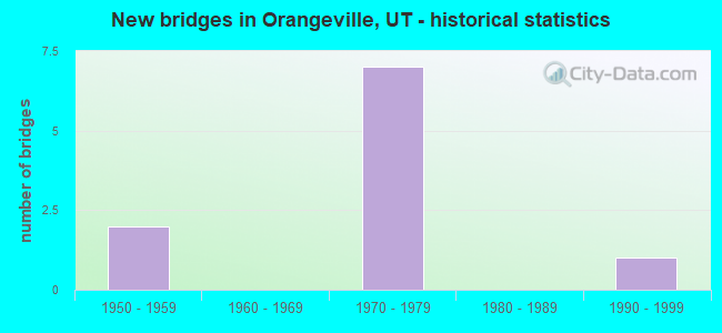
- New bridges - historical statistics
- 21950-1959
- 71970-1979
- 11990-1999


- Bridge Condition - Deck
- 83.3%Good
- 16.7%Satisfactory

- Bridge Condition - Superstructure
- 33.3%Very good
- 66.7%Satisfactory

- Bridge Condition - Substructure
- 33.3%Good
- 50.0%Satisfactory
- 16.7%Fair

- Bridge Condition - Channel
- 16.7%Very good
- 33.3%Good
- 33.3%Satisfactory
- 16.7%Fair
Find on map >> Show street view
Structure Number: 15015F, Location: 1 MILE NW. OF ORANGEVILLE (Lat: 39.245808, Lng: -111.076569), Route carried "on" structure: County highway , Year Built: 1995, Status: Open, Structure Length: 1.74m (5.71ft), Average Daily Traffic: 126 (year 2020), Average Future Daily Traffic: 153 (year 2040), Design Load: HL 93, Features Intersected: COTTONWOOD CREEK, Facility Carried by Structure: COUNTY ROAD
Minimum Vertical Clearance: 30+ m (98+ ft), Kilometerpoint: 0.011, Lanes on structure: 2, Owner: County Highway Agency, Approaching Roadway Width: 10.0m (32.8ft), Material/Design: Prestressed concrete, Design/Construction: Tee Beam, Number Of Spans In Main Unit: 1, Length of Maximum Span: 15.8m (51.8ft), Curb-To-Curb Width: 10.0m (32.8ft), Out-to-Out Width: 11.8m (38.7ft)
Condition: Deck: Good, Superstructure: Very good, Substructure: Satisfactory, Channel: Good, Operating Rating: 32.4 metric tons, Method Used To Determine Operating Rating: Load and Resistance Factor Rating (LRFR) rating reported by rating factor(RF) method using HL-93 loadings, Inventory Rating: 22.7 metric tons, Method Used To Determine Inventory Rating: Load Factor (LF) rating reported by rating factor (RF) method using MS18 loading, Structural Evaluation: Equal to present minimum criteria, Deck Geometry: Better than present minimum criteria, Waterway Adequacy: Equal to present desirable criteria, Approach Roadway Alignment: Equal to present desirable criteria, Designated Inspection Frequency: Every 22 months, Inspection Date: August 2020, Deck Structure Type: Concrete Precast Panels, Wearing Surface/Protective System: Wearing Surface: Bituminous
Find on map >> Show street view
Structure Number: 15030F, Location: 170 N. MAIN, ORANGEVILLE (Lat: 39.230600, Lng: -111.053200), Route carried "on" structure: City street 1644, Year Built: 1976, Status: Open, Structure Length: 2.76m (9.06ft), Average Daily Traffic: 830 (year 2020), Truck Traffic: 1%, Average Future Daily Traffic: 1,038 (year 2040), Design Load: HS 20+Mod, Features Intersected: COTTONWOOD CREEK, Facility Carried by Structure: ORANGEVIL.MAIN ST.
Minimum Vertical Clearance: 30+ m (98+ ft), Kilometerpoint: 1.995, Lanes on structure: 2, Owner: City or Municipal Highway Agency, Approaching Roadway Width: 9.3m (30.5ft), Material/Design: Prestressed concrete, Design/Construction: Stringer/Multi-beam, Number Of Spans In Main Unit: 1, Length of Maximum Span: 27.1m (88.9ft), Curb or Sidewalk Widths: Left: 0.0m, Right: 1.2m (3.9ft), Curb-To-Curb Width: 9.3m (30.5ft), Out-to-Out Width: 11.8m (38.7ft)
Condition: Deck: Good, Superstructure: Very good, Substructure: Good, Channel: Fair, Operating Rating: 32.4 metric tons, Method Used To Determine Operating Rating: Load and Resistance Factor Rating (LRFR) rating reported by rating factor(RF) method using HL-93 loadings, Inventory Rating: 23.0 metric tons, Method Used To Determine Inventory Rating: Load Factor (LF) rating reported by rating factor (RF) method using MS18 loading, Structural Evaluation: Equal to present minimum criteria, Deck Geometry: Equal to present minimum criteria, Waterway Adequacy: Equal to present minimum criteria, Approach Roadway Alignment: Equal to present desirable criteria, Designated Inspection Frequency: Every 22 months, Inspection Date: August 2020, Deck Structure Type: Concrete Cast-file-Place, Wearing Surface/Protective System: Wearing Surface: Bituminous
Find on map >> Show street view
Structure Number: D 608, Location: 2.8 MI.W.ORANGEVILLE JCT (Lat: 39.252442, Lng: -111.094214), Route carried "on" structure: State highway 29, Year Built: 1954, Status: Open, Structure Length: 1.94m (6.36ft), Average Daily Traffic: 377 (year 2020), Truck Traffic: 37%, Average Future Daily Traffic: 471 (year 2040), Design Load: HS 20+Mod, Features Intersected: GRIMES WASH
Minimum Vertical Clearance: 30+ m (98+ ft), Kilometerpoint: 24.233, Lanes on structure: 2, Owner: State Highway Agency, Approaching Roadway Width: 7.3m (24.0ft), Skew: 4 degrees, Material/Design: Concrete, Design/Construction: Tee Beam, Number Of Spans In Main Unit: 1, Length of Maximum Span: 14.0m (45.9ft), Curb-To-Curb Width: 7.3m (24.0ft), Out-to-Out Width: 8.4m (27.6ft)
Condition: Deck: Good, Superstructure: Satisfactory, Substructure: Satisfactory, Channel: Satisfactory, Operating Rating: 33.0 metric tons, Method Used To Determine Operating Rating: Load and Resistance Factor Rating (LRFR) rating reported by rating factor(RF) method using HL-93 loadings, Inventory Rating: 22.7 metric tons, Method Used To Determine Inventory Rating: Load and Resistance Factor Rating (LRFR) rating reported by rating factor(RF) method using HL-93 loadings, Structural Evaluation: Equal to present minimum criteria, Deck Geometry: Somewhat better than minimum adequacy, Waterway Adequacy: Somewhat better than minimum adequacy, Approach Roadway Alignment: Equal to present desirable criteria, Designated Inspection Frequency: Every 24 months, Inspection Date: August 2021, Deck Structure Type: Concrete Cast-file-Place, Wearing Surface/Protective System: Wearing Surface: Bituminous
Find on map >> Show street view
Structure Number: E2061, Location: 0.7 MI.NO.OF JCT.W/ SR-10 (Lat: 39.187336, Lng: -111.047642), Route carried "on" structure: State highway 57, Year Built: 1951, Year Reconstructed: 1978, Status: Open, Structure Length: 1.17m (3.84ft), Average Daily Traffic: 528 (year 2020), Truck Traffic: 48%, Average Future Daily Traffic: 660 (year 2040), Design Load: H 15, Features Intersected: SOUTH WASH
Minimum Vertical Clearance: 30+ m (98+ ft), Kilometerpoint: 1.277, Lanes on structure: 2, Owner: State Highway Agency, Approaching Roadway Width: 10.4m (34.1ft), Material/Design: Concrete continuous, Design/Construction: Culvert, Number Of Spans In Main Unit: 2, Length of Maximum Span: 5.5m (18.0ft), Curb-To-Curb Width: 10.4m (34.1ft), Out-to-Out Width: 17.2m (56.4ft)
Condition: Channel: Satisfactory, Culverts: Satisfactory, Operating Rating: 32.4 metric tons, Method Used To Determine Operating Rating: Load and Resistance Factor Rating (LRFR) rating reported by rating factor(RF) method using HL-93 loadings, Inventory Rating: 19.1 metric tons, Method Used To Determine Inventory Rating: Load Factor (LF) rating reported by rating factor (RF) method using MS18 loading, Structural Evaluation: Somewhat better than minimum adequacy, Deck Geometry: Equal to present minimum criteria, Waterway Adequacy: Equal to present minimum criteria, Approach Roadway Alignment: Equal to present desirable criteria, Designated Inspection Frequency: Every 24 months, Inspection Date: August 2021
Find on map >> Show street view
Structure Number: E2067, Location: 3 MILES NW.OF ORANGEVILLE (Lat: 39.252156, Lng: -111.097253), Route carried "on" structure: State highway 57, Year Built: 1978, Status: Open, Structure Length: 0.78m (2.56ft), Average Daily Traffic: 162 (year 2020), Truck Traffic: 48%, Average Future Daily Traffic: 203 (year 2040), Design Load: HS 20+Mod, Features Intersected: HUNTINGTON CANAL
Minimum Vertical Clearance: 30+ m (98+ ft), Kilometerpoint: 10.494, Lanes on structure: 2, Owner: State Highway Agency, Approaching Roadway Width: 11.0m (36.1ft), Skew: 3 degrees, Material/Design: Concrete, Design/Construction: Culvert, Number Of Spans In Main Unit: 1, Length of Maximum Span: 7.0m (23.0ft), Curb-To-Curb Width: 11.0m (36.1ft), Out-to-Out Width: 17.6m (57.7ft)
Condition: Channel: Good, Culverts: Satisfactory, Operating Rating: 40.2 metric tons, Method Used To Determine Operating Rating: Load Factor (LF) rating reported by rating factor (RF) method using MS18 loading, Inventory Rating: 29.5 metric tons, Method Used To Determine Inventory Rating: Load Factor (LF) rating reported by rating factor (RF) method using MS18 loading, Structural Evaluation: Equal to present minimum criteria, Deck Geometry: Equal to present desirable criteria, Waterway Adequacy: Better than present minimum criteria, Approach Roadway Alignment: Equal to present desirable criteria, Designated Inspection Frequency: Every 24 months, Inspection Date: August 2021
Find on map >> Show street view
Structure Number: F 408, Location: 3 MILES NW,OF ORANGEVILLE (Lat: 39.254922, Lng: -111.098172), Route carried "on" structure: State highway 29, Year Built: 1978, Status: Open, Structure Length: 5.61m (18.41ft), Average Daily Traffic: 1,225 (year 2020), Truck Traffic: 38%, Average Future Daily Traffic: 1,531 (year 2040), Design Load: HS 20+Mod, Features Intersected: SR-57,UP&L COAL HAUL
Minimum Vertical Clearance: 30+ m (98+ ft), Kilometerpoint: 23.794, Lanes on structure: 2, Lanes under structure: 2, Owner: State Highway Agency, Approaching Roadway Width: 11.7m (38.4ft), Skew: 4 degrees, Material/Design: Prestressed concrete continuous, Design/Construction: Stringer/Multi-beam, Number Of Spans In Main Unit: 3, Length of Maximum Span: 26.0m (85.3ft), Curb-To-Curb Width: 11.7m (38.4ft), Out-to-Out Width: 12.8m (42.0ft)
Condition: Deck: Satisfactory, Superstructure: Satisfactory, Substructure: Fair, Operating Rating: 49.2 metric tons, Method Used To Determine Operating Rating: Load and Resistance Factor Rating (LRFR) rating reported by rating factor(RF) method using HL-93 loadings, Inventory Rating: 37.6 metric tons, Method Used To Determine Inventory Rating: Load Factor (LF) rating reported by rating factor (RF) method using MS18 loading, Structural Evaluation: Somewhat better than minimum adequacy, Deck Geometry: Equal to present minimum criteria, Underclear: Superior to present desirable criteria, Approach Roadway Alignment: Equal to present desirable criteria, Designated Inspection Frequency: Every 24 months, Inspection Date: August 2021, Deck Structure Type: Concrete Cast-file-Place, Wearing Surface/Protective System: Wearing Surface: Bituminous
Find on map >> Show street view
Structure Number: F 409, Location: NEAR UP and L CASTLEDALE (Lat: 39.175997, Lng: -111.046708), Route carried "on" structure: State highway 57, Year Built: 1977, Status: Open, Structure Length: 5.58m (18.31ft), Average Daily Traffic: 528 (year 2020), Truck Traffic: 48%, Average Future Daily Traffic: 660 (year 2040), Design Load: HS 20+Mod, Features Intersected: SR-10
Minimum Vertical Clearance: 30+ m (98+ ft), Kilometerpoint: 0.003, Lanes on structure: 2, Lanes under structure: 3, Owner: State Highway Agency, Approaching Roadway Width: 11.1m (36.4ft), Material/Design: Prestressed concrete continuous, Design/Construction: Stringer/Multi-beam, Number Of Spans In Main Unit: 3, Length of Maximum Span: 32.5m (106.6ft), Curb-To-Curb Width: 11.1m (36.4ft), Out-to-Out Width: 12.1m (39.7ft)
Condition: Deck: Good, Superstructure: Satisfactory, Substructure: Good, Operating Rating: 43.4 metric tons, Method Used To Determine Operating Rating: Load Factor (LF) rating reported by rating factor (RF) method using MS18 loading, Inventory Rating: 32.4 metric tons, Method Used To Determine Inventory Rating: Load Factor (LF) rating reported by rating factor (RF) method using MS18 loading, Structural Evaluation: Equal to present minimum criteria, Deck Geometry: Better than present minimum criteria, Underclear: Equal to present minimum criteria, Approach Roadway Alignment: Equal to present desirable criteria, Designated Inspection Frequency: Every 24 months, Inspection Date: August 2021, Deck Structure Type: Concrete Cast-file-Place, Wearing Surface/Protective System: Wearing Surface: Bituminous, Membrane: Preformed Fabric
Find on map >> Show street view
Structure Number: F 413, Location: 3 MILES NW.of ORANGEVILLE (Lat: 39.248050, Lng: -111.093958), Route carried "on" structure: State highway 57, Year Built: 1978, Status: Open, Structure Length: 3.81m (12.50ft), Average Daily Traffic: 162 (year 2020), Truck Traffic: 48%, Average Future Daily Traffic: 203 (year 2040), Design Load: HS 20+Mod, Features Intersected: COTTONWOOD CREEK
Minimum Vertical Clearance: 30+ m (98+ ft), Kilometerpoint: 9.955, Lanes on structure: 2, Owner: State Highway Agency, Approaching Roadway Width: 10.5m (34.4ft), Skew: 1 degrees, Material/Design: Prestressed concrete, Design/Construction: Stringer/Multi-beam, Number Of Spans In Main Unit: 1, Length of Maximum Span: 37.3m (122.4ft), Curb-To-Curb Width: 10.5m (34.4ft), Out-to-Out Width: 12.2m (40.0ft)
Condition: Deck: Good, Superstructure: Satisfactory, Substructure: Satisfactory, Channel: Very good, Operating Rating: 46.0 metric tons, Method Used To Determine Operating Rating: Load Factor (LF) rating reported by rating factor (RF) method using MS18 loading, Inventory Rating: 18.5 metric tons, Method Used To Determine Inventory Rating: Load Factor (LF) rating reported by rating factor (RF) method using MS18 loading, Structural Evaluation: Somewhat better than minimum adequacy, Deck Geometry: Better than present minimum criteria, Waterway Adequacy: Better than present minimum criteria, Approach Roadway Alignment: Equal to present desirable criteria, Designated Inspection Frequency: Every 24 months, Inspection Date: August 2021, Deck Structure Type: Concrete Cast-file-Place, Wearing Surface/Protective System: Wearing Surface: Bituminous
Find on map >> Show street view
Structure Number: F 408, Location: 3 MILES NW,OF ORANGEVILLE (Lat: 39.254922, Lng: -111.098172), Route carried "under" structure: State highway 57, Year Built: 1978, Structure Length: 0. m, Average Daily Traffic: 162 (year 2020), Truck Traffic: 48%, Features Intersected: SR-57,UP&L COAL HAUL, Facility Carried by Structure: SR-29
Minimum Vertical Clearance: 5.08m (16.67ft), Kilometerpoint: 10.717, Lanes on structure: 2, Lanes under structure: 2, Material/Design: Prestressed concrete continuous, Design/Construction: Stringer/Multi-beam, Length of Maximum Span: 26.0m (85.3ft)
Find on map >> Show street view
Structure Number: F 409, Location: NEAR UP and L CASTLEDALE (Lat: 39.175997, Lng: -111.046708), Route carried "under" structure: State highway 10, Year Built: 1977, Structure Length: 0. m, Average Daily Traffic: 7,458 (year 2020), Truck Traffic: 50%, Features Intersected: SR-10, Facility Carried by Structure: SR-57
Minimum Vertical Clearance: 4.88m (16.01ft), Kilometerpoint: 55.844, Lanes on structure: 2, Lanes under structure: 3, Material/Design: Prestressed concrete continuous, Design/Construction: Stringer/Multi-beam, Length of Maximum Span: 32.5m (106.6ft)