Bridge Statistics for Orchard Park, New York (NY)
Condition, Traffic, Stress, Structural Evaluation, Project Costs
- National Bridge Inventory (NBI) Statistics
- 38Number of bridges
- 259ft / 79.0mTotal length
- $68,502,000Total costs
- 279,825Total average daily traffic
- 8,097Total average daily truck traffic
- National Bridge Inventory (NBI) Registered Bridges for Orchard Park
- No street view available for this location
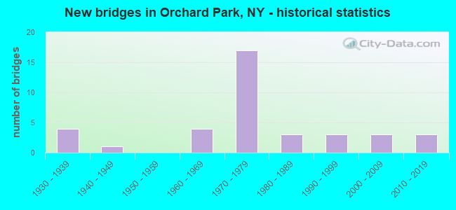
- New bridges - historical statistics
- 41930-1939
- 11940-1949
- 41960-1969
- 171970-1979
- 31980-1989
- 31990-1999
- 32000-2009
- 32010-2019

- Reconstructed bridges - Historical Statistics
- 21980-1989
- 01990-1999
- 02000-2009
- 22010-2019


- Bridge Condition - Deck
- 64.3%Good
- 21.4%Satisfactory
- 7.1%Fair
- 7.1%Poor

- Bridge Condition - Superstructure
- 40.0%Very good
- 26.7%Good
- 20.0%Satisfactory
- 13.3%Poor

- Bridge Condition - Substructure
- 53.3%Good
- 13.3%Satisfactory
- 33.3%Fair

- Bridge Condition - Channel
- 20.0%Very good
- 40.0%Good
- 15.0%Satisfactory
- 15.0%Fair
- 5.0%Poor
- 5.0%Serious

- Bridge Condition - Culverts
- 14.3%Excellent
- 35.7%Very good
- 14.3%Good
- 28.6%Satisfactory
- 7.1%Fair
Find on map >> Show street view
Structure Number: 101606, Location: .2 MI SW JCT US20A &US219 (Lat: 42.763419, Lng: -78.761772), Route carried "on" structure: US 20A, Year Built: 1948, Year Reconstructed: 1986, Status: Open, Structure Length: 0.76m (2.49ft), Average Daily Traffic: 10,490 (year 2018), Truck Traffic: 4%, Average Future Daily Traffic: 10,539 (year 2040), Design Load: HS 20, Features Intersected: S BR SMOKES CREEK
Minimum Vertical Clearance: 30+ m (98+ ft), Kilometerpoint: 4.039, Lanes on structure: 3, Base Highway Network: Yes, Owner: State Highway Agency, Approaching Roadway Width: 21.3m (69.9ft), Skew: 1 degrees, Material/Design: Concrete, Design/Construction: Slab, Number Of Spans In Main Unit: 1, Length of Maximum Span: 7.3m (24.0ft), Curb-To-Curb Width: 21.3m (69.9ft), Out-to-Out Width: 21.9m (71.9ft)
Condition: Superstructure: Poor, Substructure: Fair, Channel: Very good, Operating Rating: 56.2 metric tons, Method Used To Determine Operating Rating: Load Factor (LF), Inventory Rating: 33.6 metric tons, Method Used To Determine Inventory Rating: Load Factor (LF), Structural Evaluation: Meets minimum limits, Deck Geometry: Superior to present desirable criteria, Waterway Adequacy: Equal to present minimum criteria, Approach Roadway Alignment: Equal to present desirable criteria, Length Of Structure Improvement: 0.76m (2.49ft), Designated Inspection Frequency: Every 24 months, Inspection Date: June 2021, Bridge Improvement Cost: $909,000, Roadway Improvement Cost: $532,000, Total Project Cost: $1,441,000 ( Estimate for 2021), Deck Structure Type: Concrete Cast-file-Place, Wearing Surface/Protective System: Wearing Surface: Bituminous
Find on map >> Show street view
Structure Number: 101607, Location: .4 MI SW JCT US20A &SH219 (Lat: 42.763486, Lng: -78.756850), Route carried "on" structure: US 20A, Year Built: 1986, Status: Open, Structure Length: 4.91m (16.11ft), Average Daily Traffic: 10,490 (year 2018), Truck Traffic: 4%, Average Future Daily Traffic: 10,539 (year 2040), Design Load: HS 20, Features Intersected: BUFF & PITT RR
Minimum Vertical Clearance: 30+ m (98+ ft), Kilometerpoint: 4.441, Lanes on structure: 2, Base Highway Network: Yes, Owner: State Highway Agency, Approaching Roadway Width: 14.6m (47.9ft), Skew: 4 degrees, Material/Design: Prestressed concrete continuous, Design/Construction: Box Beam or Girders - Multiple, Number Of Spans In Main Unit: 3, Length of Maximum Span: 18.8m (61.7ft), Curb-To-Curb Width: 14.0m (45.9ft), Out-to-Out Width: 15.0m (49.2ft)
Condition: Deck: Satisfactory, Superstructure: Satisfactory, Substructure: Good, Operating Rating: 72.6 metric tons, Method Used To Determine Operating Rating: Load Factor (LF), Inventory Rating: 15.4 metric tons, Method Used To Determine Inventory Rating: Load Factor (LF), Structural Evaluation: High priority of corrective action, Deck Geometry: Superior to present desirable criteria, Underclear: Meets minimum limits, Approach Roadway Alignment: Equal to present desirable criteria, Length Of Structure Improvement: 4.90m (16.08ft), Designated Inspection Frequency: Every 24 months, Inspection Date: November 2020, Bridge Improvement Cost: $1,925,000, Roadway Improvement Cost: $1,127,000, Total Project Cost: $3,052,000 ( Estimate for 2021), Deck Structure Type: Concrete Cast-file-Place, Wearing Surface/Protective System: Wearing Surface: Integral Concrete, Deck Protection: Epoxy Coated Reinforcing
Find on map >> Show street view
Structure Number: 101608, Location: 1 MI E JCT US 20A & SH277 (Lat: 42.771053, Lng: -78.724594), Route carried "on" structure: US 20A, Year Built: 1992, Status: Open, Structure Length: 0.88m (2.89ft), Average Daily Traffic: 6,245 (year 2020), Truck Traffic: 5%, Average Future Daily Traffic: 6,274 (year 2040), Design Load: HS 20, Features Intersected: W BR SMOKES CREEK
Minimum Vertical Clearance: 30+ m (98+ ft), Kilometerpoint: 7.241, Lanes on structure: 2, Base Highway Network: Yes, Owner: State Highway Agency, Approaching Roadway Width: 13.4m (44.0ft), Material/Design: Prestressed concrete, Design/Construction: Box Beam or Girders - Multiple, Number Of Spans In Main Unit: 1, Length of Maximum Span: 7.9m (25.9ft), Curb-To-Curb Width: 13.4m (44.0ft), Out-to-Out Width: 14.4m (47.2ft)
Condition: Deck: Good, Superstructure: Very good, Substructure: Good, Channel: Very good, Operating Rating: 53.1 metric tons, Method Used To Determine Operating Rating: Load and Resistance Factor Rating (LRFR) rating reported by rating factor(RF) method using HL-93 loadings, Inventory Rating: 40.8 metric tons, Method Used To Determine Inventory Rating: Load and Resistance Factor Rating (LRFR) rating reported by rating factor(RF) method using HL-93 loadings, Structural Evaluation: Better than present minimum criteria, Deck Geometry: Equal to present minimum criteria, Waterway Adequacy: Equal to present minimum criteria, Approach Roadway Alignment: Equal to present desirable criteria, Length Of Structure Improvement: 0.88m (2.89ft), Designated Inspection Frequency: Every 24 months, Inspection Date: April 2020, Bridge Improvement Cost: $843,000, Roadway Improvement Cost: $493,000, Total Project Cost: $1,336,000 ( Estimate for 2021), Wearing Surface/Protective System: Wearing Surface: Monolithic Concrete
Find on map >> Show street view
Structure Number: 104421, Location: 3.5 MI N JCT RTS 219 +277 (Lat: 42.720681, Lng: -78.747664), Route carried "on" structure: Other road , Year Built: 1964, Status: Open, Structure Length: 2.93m (9.61ft), Average Daily Traffic: 112 (year 2020), Truck Traffic: 4%, Average Future Daily Traffic: 157 (year 2040), Design Load: HS 20+Mod, Features Intersected: RTE 277, Facility Carried by Structure: COUNTY PARK RD
Minimum Vertical Clearance: 30+ m (98+ ft), Kilometerpoint: 2.269, Lanes on structure: 2, Lanes under structure: 2, Owner: State Highway Agency, Approaching Roadway Width: 9.1m (29.9ft), Skew: 1 degrees, Material/Design: Steel, Design/Construction: Stringer/Multi-beam, Number Of Spans In Main Unit: 1, Length of Maximum Span: 27.4m (89.9ft), Curb or Sidewalk Widths: Left: 1.2m (3.9ft), Right: 1.2m (3.9ft), Curb-To-Curb Width: 7.3m (24.0ft), Out-to-Out Width: 10.2m (33.5ft)
Condition: Deck: Good, Superstructure: Good, Substructure: Fair, Operating Rating: 70.8 metric tons, Method Used To Determine Operating Rating: Load Factor (LF), Inventory Rating: 41.7 metric tons, Method Used To Determine Inventory Rating: Load Factor (LF), Structural Evaluation: Somewhat better than minimum adequacy, Deck Geometry: Somewhat better than minimum adequacy, Underclear: Somewhat better than minimum adequacy, Approach Roadway Alignment: High priority of replacement, Length Of Structure Improvement: 2.92m (9.58ft), Designated Inspection Frequency: Every 24 months, Inspection Date: June 2020, Bridge Improvement Cost: $1,351,000, Roadway Improvement Cost: $791,000, Total Project Cost: $2,143,000 ( Estimate for 2021), Deck Structure Type: Concrete Cast-file-Place, Wearing Surface/Protective System: Wearing Surface: Bituminous
Find on map >> Show street view
Structure Number: 106288, Location: 0.5 MI S JCT RTS 219 +20A (Lat: 42.756558, Lng: -78.762731), Route carried "on" structure: County highway , Year Built: 1972, Status: Open, Structure Length: 6.37m (20.90ft), Average Daily Traffic: 1,303 (year 2017), Truck Traffic: 2%, Average Future Daily Traffic: 1,824 (year 2037), Design Load: HS 20, Features Intersected: 219 219 53121211, RTE 21, Facility Carried by Structure: COUNTY ROAD 463
Minimum Vertical Clearance: 30+ m (98+ ft), Kilometerpoint: 0.998, Lanes on structure: 2, Lanes under structure: 4, Owner: State Highway Agency, Approaching Roadway Width: 11.0m (36.1ft), Skew: 2 degrees, Material/Design: Steel, Design/Construction: Stringer/Multi-beam, Number Of Spans In Main Unit: 2, Length of Maximum Span: 30.7m (100.7ft), Curb-To-Curb Width: 10.7m (35.1ft), Out-to-Out Width: 11.6m (38.1ft)
Condition: Deck: Good, Superstructure: Very good, Substructure: Satisfactory, Operating Rating: 89.8 metric tons, Method Used To Determine Operating Rating: Load Factor (LF), Inventory Rating: 53.5 metric tons, Method Used To Determine Inventory Rating: Load Factor (LF), Structural Evaluation: Equal to present minimum criteria, Deck Geometry: Equal to present minimum criteria, Underclear: High priority of corrective action, Approach Roadway Alignment: Somewhat better than minimum adequacy, Length Of Structure Improvement: 6.37m (20.90ft), Designated Inspection Frequency: Every 24 months, Inspection Date: July 2020, Bridge Improvement Cost: $2,933,000, Roadway Improvement Cost: $1,718,000, Total Project Cost: $4,651,000 ( Estimate for 2021), Deck Structure Type: Concrete Cast-file-Place, Wearing Surface/Protective System: Wearing Surface: Integral Concrete
Find on map >> Show street view
Structure Number: 1062891, Location: JCT RTS 219 + 20A (Lat: 42.763914, Lng: -78.765300), Route carried "on" structure: US 219, Year Built: 1972, Status: Open, Structure Length: 3.87m (12.70ft), Average Daily Traffic: 10,251 (year 2019), Truck Traffic: 5%, Average Future Daily Traffic: 11,879 (year 2040), Features Intersected: RTE 20A
Minimum Vertical Clearance: 30+ m (98+ ft), Kilometerpoint: 35.318, Lanes on structure: 2, Lanes under structure: 4, Base Highway Network: Yes, Owner: State Highway Agency, Approaching Roadway Width: 13.7m (44.9ft), Skew: 2 degrees, Material/Design: Steel, Design/Construction: Stringer/Multi-beam, Number Of Spans In Main Unit: 1, Length of Maximum Span: 37.4m (122.7ft), Curb-To-Curb Width: 11.9m (39.0ft), Out-to-Out Width: 12.8m (42.0ft)
Condition: Deck: Good, Superstructure: Very good, Substructure: Good, Operating Rating: 68.9 metric tons, Method Used To Determine Operating Rating: Load Factor (LF), Inventory Rating: 40.8 metric tons, Method Used To Determine Inventory Rating: Load Factor (LF), Structural Evaluation: Better than present minimum criteria, Deck Geometry: Equal to present minimum criteria, Underclear: Somewhat better than minimum adequacy, Approach Roadway Alignment: Equal to present minimum criteria, Length Of Structure Improvement: 3.87m (12.70ft), Designated Inspection Frequency: Every 24 months, Inspection Date: July 2020, Bridge Improvement Cost: $2,374,000, Roadway Improvement Cost: $1,390,000, Total Project Cost: $3,764,000 ( Estimate for 2021), Deck Structure Type: Concrete Cast-file-Place, Wearing Surface/Protective System: Wearing Surface: Monolithic Concrete
Find on map >> Show street view
Structure Number: 1062892, Location: JCT RTS 219 + 20A (Lat: 42.763864, Lng: -78.764889), Route carried "on" structure: US 219, Year Built: 1972, Status: Open, Structure Length: 3.87m (12.70ft), Average Daily Traffic: 10,251 (year 2019), Truck Traffic: 5%, Average Future Daily Traffic: 11,879 (year 2040), Features Intersected: RTE 20A
Minimum Vertical Clearance: 30+ m (98+ ft), Kilometerpoint: 35.318, Lanes on structure: 2, Lanes under structure: 4, Base Highway Network: Yes, Owner: State Highway Agency, Approaching Roadway Width: 13.7m (44.9ft), Skew: 2 degrees, Material/Design: Steel, Design/Construction: Stringer/Multi-beam, Number Of Spans In Main Unit: 1, Length of Maximum Span: 37.4m (122.7ft), Curb-To-Curb Width: 11.9m (39.0ft), Out-to-Out Width: 12.8m (42.0ft)
Condition: Deck: Good, Superstructure: Very good, Substructure: Good, Operating Rating: 67.1 metric tons, Method Used To Determine Operating Rating: Load Factor (LF), Inventory Rating: 39.9 metric tons, Method Used To Determine Inventory Rating: Load Factor (LF), Structural Evaluation: Better than present minimum criteria, Deck Geometry: Equal to present minimum criteria, Underclear: Somewhat better than minimum adequacy, Approach Roadway Alignment: Equal to present minimum criteria, Length Of Structure Improvement: 3.87m (12.70ft), Designated Inspection Frequency: Every 24 months, Inspection Date: July 2020, Bridge Improvement Cost: $2,374,000, Roadway Improvement Cost: $1,390,000, Total Project Cost: $3,764,000 ( Estimate for 2021), Deck Structure Type: Concrete Cast-file-Place, Wearing Surface/Protective System: Wearing Surface: Monolithic Concrete
Find on map >> Show street view
Structure Number: 1062901, Location: .7 MI N JCT US219 & US20A (Lat: 42.773006, Lng: -78.767972), Route carried "on" structure: US 219, Year Built: 1972, Year Reconstructed: 2017, Status: Open, Structure Length: 11.61m (38.09ft), Average Daily Traffic: 15,573 (year 2020), Truck Traffic: 5%, Average Future Daily Traffic: 18,045 (year 2040), Design Load: HS 20, Features Intersected: TAYLOR RD-CR 177, BUFF &
Minimum Vertical Clearance: 30+ m (98+ ft), Kilometerpoint: 36.267, Lanes on structure: 2, Lanes under structure: 2, Base Highway Network: Yes, Owner: State Highway Agency, Approaching Roadway Width: 12.2m (40.0ft), Skew: 6 degrees, Material/Design: Steel, Design/Construction: Stringer/Multi-beam, Number Of Spans In Main Unit: 4, Length of Maximum Span: 36.5m (119.8ft), Curb-To-Curb Width: 11.9m (39.0ft), Out-to-Out Width: 12.8m (42.0ft)
Condition: Deck: Good, Superstructure: Good, Substructure: Good, Operating Rating: 64.4 metric tons, Method Used To Determine Operating Rating: Load Factor (LF), Inventory Rating: 38.1 metric tons, Method Used To Determine Inventory Rating: Load Factor (LF), Structural Evaluation: Better than present minimum criteria, Deck Geometry: Equal to present minimum criteria, Underclear: Meets minimum limits, Approach Roadway Alignment: Equal to present desirable criteria, Length Of Structure Improvement: 11.61m (38.09ft), Designated Inspection Frequency: Every 24 months, Inspection Date: August 2021, Bridge Improvement Cost: $5,531,000, Roadway Improvement Cost: $3,239,000, Total Project Cost: $8,770,000 ( Estimate for 2021), Deck Structure Type: Concrete Cast-file-Place, Wearing Surface/Protective System: Wearing Surface: Monolithic Concrete
Find on map >> Show street view
Structure Number: 1062902, Location: .7 MI N JCT SH219 & US20A (Lat: 42.772564, Lng: -78.767450), Route carried "on" structure: US 219, Year Built: 1972, Year Reconstructed: 2017, Status: Open, Structure Length: 11.61m (38.09ft), Average Daily Traffic: 15,573 (year 2020), Truck Traffic: 5%, Average Future Daily Traffic: 18,045 (year 2040), Design Load: HS 20, Features Intersected: TAYLOR RD-CR 177, BUFF &
Minimum Vertical Clearance: 30+ m (98+ ft), Kilometerpoint: 36.267, Lanes on structure: 2, Lanes under structure: 2, Base Highway Network: Yes, Owner: State Highway Agency, Approaching Roadway Width: 12.2m (40.0ft), Skew: 6 degrees, Material/Design: Steel, Design/Construction: Stringer/Multi-beam, Number Of Spans In Main Unit: 4, Length of Maximum Span: 36.5m (119.8ft), Curb-To-Curb Width: 11.9m (39.0ft), Out-to-Out Width: 12.8m (42.0ft)
Condition: Deck: Good, Superstructure: Good, Substructure: Good, Operating Rating: 64.4 metric tons, Method Used To Determine Operating Rating: Load Factor (LF), Inventory Rating: 38.1 metric tons, Method Used To Determine Inventory Rating: Load Factor (LF), Structural Evaluation: Better than present minimum criteria, Deck Geometry: Equal to present minimum criteria, Underclear: Meets minimum limits, Approach Roadway Alignment: Equal to present desirable criteria, Length Of Structure Improvement: 11.61m (38.09ft), Designated Inspection Frequency: Every 24 months, Inspection Date: August 2021, Bridge Improvement Cost: $5,585,000, Roadway Improvement Cost: $3,270,000, Total Project Cost: $8,855,000 ( Estimate for 2021), Deck Structure Type: Concrete Cast-file-Place, Wearing Surface/Protective System: Wearing Surface: Monolithic Concrete
Find on map >> Show street view
Structure Number: 1063, Location: .1 MI N JCT US219 & US20A (Lat: 42.764658, Lng: -78.765506), Route carried "on" structure: US 219, Year Built: 1972, Status: Open, Structure Length: 0.73m (2.40ft), Average Daily Traffic: 31,145 (year 2020), Truck Traffic: 5%, Average Future Daily Traffic: 36,090 (year 2040), Features Intersected: S BR SMOKES CREEK
Minimum Vertical Clearance: 30+ m (98+ ft), Kilometerpoint: 35.414, Lanes on structure: 4, Base Highway Network: Yes, Owner: State Highway Agency, Approaching Roadway Width: 24.4m (80.1ft), Skew: 22 degrees, Material/Design: Steel, Design/Construction: Culvert, Number Of Spans In Main Unit: 2, Length of Maximum Span: 3.0m (9.8ft)
Condition: Channel: Very good, Culverts: Very good, Operating Rating: 74.8 metric tons, Method Used To Determine Operating Rating: Field evaluation and documented engineering judgment, Inventory Rating: 32.7 metric tons, Method Used To Determine Inventory Rating: Field evaluation and documented engineering judgment, Structural Evaluation: Equal to present desirable criteria, Waterway Adequacy: Equal to present minimum criteria, Approach Roadway Alignment: Better than present minimum criteria, Length Of Structure Improvement: 0.73m (2.40ft), Designated Inspection Frequency: Every 24 months, Inspection Date: August 2021, Bridge Improvement Cost: $493,000, Roadway Improvement Cost: $289,000, Total Project Cost: $781,000 ( Estimate for 2021), Wearing Surface/Protective System: Wearing Surface: Bituminous
Find on map >> Show street view
Structure Number: 106301, Location: 0.1 MI N JCT RTS 219 +20A (Lat: 42.764400, Lng: -78.763956), Route carried "on" structure: Ramp US 219, Year Built: 1972, Status: Open, Structure Length: 0.70m (2.30ft), Average Daily Traffic: 3,120 (year 2016), Truck Traffic: 15%, Average Future Daily Traffic: 3,615 (year 2040), Features Intersected: S BR SMOKES CREEK
Minimum Vertical Clearance: 30+ m (98+ ft), Kilometerpoint: 0.080, Lanes on structure: 1, Owner: State Highway Agency, Approaching Roadway Width: 10.1m (33.1ft), Skew: 4 degrees, Material/Design: Steel, Design/Construction: Culvert, Number Of Spans In Main Unit: 2, Length of Maximum Span: 3.3m (10.8ft)
Condition: Channel: Satisfactory, Culverts: Good, Operating Rating: 74.9 metric tons, Method Used To Determine Operating Rating: Field evaluation and documented engineering judgment, Inventory Rating: 32.7 metric tons, Method Used To Determine Inventory Rating: Field evaluation and documented engineering judgment, Structural Evaluation: Better than present minimum criteria, Waterway Adequacy: Equal to present minimum criteria, Approach Roadway Alignment: Somewhat better than minimum adequacy, Length Of Structure Improvement: 0.70m (2.30ft), Designated Inspection Frequency: Every 24 months, Inspection Date: July 2021, Bridge Improvement Cost: $195,000, Roadway Improvement Cost: $114,000, Total Project Cost: $309,000 ( Estimate for 2021)
Find on map >> Show street view
Structure Number: 106307, Location: 1.7 MI E JCT RTS 20A+ 277 (Lat: 42.770775, Lng: -78.711700), Route carried "on" structure: US 20A, Year Built: 1962, Status: Open, Structure Length: 0.82m (2.69ft), Average Daily Traffic: 6,245 (year 2020), Truck Traffic: 5%, Average Future Daily Traffic: 6,274 (year 2040), Design Load: HS 20, Features Intersected: SMOKES CREEK
Minimum Vertical Clearance: 30+ m (98+ ft), Kilometerpoint: 8.302, Lanes on structure: 2, Base Highway Network: Yes, Owner: State Highway Agency, Approaching Roadway Width: 13.4m (44.0ft), Skew: 2 degrees, Material/Design: Steel, Design/Construction: Culvert, Number Of Spans In Main Unit: 2, Length of Maximum Span: 3.6m (11.8ft)
Condition: Channel: Good, Culverts: Satisfactory, Operating Rating: 75.1 metric tons, Method Used To Determine Operating Rating: Field evaluation and documented engineering judgment, Inventory Rating: 32.7 metric tons, Method Used To Determine Inventory Rating: Field evaluation and documented engineering judgment, Structural Evaluation: Equal to present minimum criteria, Waterway Adequacy: Somewhat better than minimum adequacy, Approach Roadway Alignment: Equal to present minimum criteria, Length Of Structure Improvement: 0.82m (2.69ft), Designated Inspection Frequency: Every 24 months, Inspection Date: June 2021, Bridge Improvement Cost: $305,000, Roadway Improvement Cost: $179,000, Total Project Cost: $483,000 ( Estimate for 2021), Wearing Surface/Protective System: Wearing Surface: Bituminous
Find on map >> Show street view
Structure Number: 109221, Location: 1.9MI S JCT RTS 20A & 219 (Lat: 42.735769, Lng: -78.766281), Route carried "on" structure: County highway , Year Built: 1977, Status: Open, Structure Length: 6.68m (21.92ft), Average Daily Traffic: 1,540 (year 2017), Truck Traffic: 2%, Average Future Daily Traffic: 1,905 (year 2040), Design Load: HS 20, Features Intersected: 219 219 53121196 NB, RTE, Facility Carried by Structure: COUNTY ROAD 370
Minimum Vertical Clearance: 30+ m (98+ ft), Kilometerpoint: 1.947, Lanes on structure: 2, Lanes under structure: 4, Owner: State Highway Agency, Approaching Roadway Width: 13.4m (44.0ft), Skew: 2 degrees, Material/Design: Steel, Design/Construction: Stringer/Multi-beam, Number Of Spans In Main Unit: 2, Length of Maximum Span: 32.6m (107.0ft), Curb-To-Curb Width: 13.1m (43.0ft), Out-to-Out Width: 14.0m (45.9ft)
Condition: Deck: Satisfactory, Superstructure: Very good, Substructure: Good, Operating Rating: 86.2 metric tons, Method Used To Determine Operating Rating: Load Factor (LF), Inventory Rating: 51.7 metric tons, Method Used To Determine Inventory Rating: Load Factor (LF), Structural Evaluation: Better than present minimum criteria, Deck Geometry: Better than present minimum criteria, Underclear: Equal to present minimum criteria, Approach Roadway Alignment: Equal to present desirable criteria, Length Of Structure Improvement: 6.67m (21.88ft), Designated Inspection Frequency: Every 24 months, Inspection Date: October 2021, Bridge Improvement Cost: $3,772,000, Roadway Improvement Cost: $2,209,000, Total Project Cost: $5,980,000 ( Estimate for 2021), Deck Structure Type: Concrete Cast-file-Place, Wearing Surface/Protective System: Wearing Surface: Integral Concrete
Find on map >> Show street view
Structure Number: 109222, Location: 1.0MI S JCT RTS 20A & 219 (Lat: 42.749153, Lng: -78.760647), Route carried "on" structure: State highway 952J, Year Built: 1977, Status: Open, Structure Length: 9.30m (30.51ft), Average Daily Traffic: 8,039 (year 2020), Truck Traffic: 6%, Average Future Daily Traffic: 8,489 (year 2040), Design Load: HS 20, Features Intersected: 219 219 53121206 NB, RTE
Minimum Vertical Clearance: 30+ m (98+ ft), Kilometerpoint: 0.595, Lanes on structure: 3, Lanes under structure: 4, Base Highway Network: Yes, Owner: State Highway Agency, Approaching Roadway Width: 19.5m (64.0ft), Material/Design: Steel, Design/Construction: Stringer/Multi-beam, Number Of Spans In Main Unit: 3, Length of Maximum Span: 30.7m (100.7ft), Curb-To-Curb Width: 19.2m (63.0ft), Out-to-Out Width: 20.1m (65.9ft)
Condition: Deck: Good, Superstructure: Very good, Substructure: Satisfactory, Operating Rating: 55.1 metric tons, Method Used To Determine Operating Rating: Load and Resistance Factor Rating (LRFR) rating reported by rating factor(RF) method using HL-93 loadings, Inventory Rating: 42.4 metric tons, Method Used To Determine Inventory Rating: Load and Resistance Factor Rating (LRFR) rating reported by rating factor(RF) method using HL-93 loadings, Structural Evaluation: Equal to present minimum criteria, Deck Geometry: Superior to present desirable criteria, Underclear: Equal to present minimum criteria, Approach Roadway Alignment: Equal to present desirable criteria, Length Of Structure Improvement: 9.29m (30.48ft), Designated Inspection Frequency: Every 24 months, Inspection Date: June 2021, Bridge Improvement Cost: $7,046,000, Roadway Improvement Cost: $4,126,000, Total Project Cost: $11,172,000 ( Estimate for 2021), Deck Structure Type: Concrete Cast-file-Place, Wearing Surface/Protective System: Wearing Surface: Integral Concrete
Find on map >> Show street view
Structure Number: 22134, Location: 0.8 MI. E OF ORCHARD PARK (Lat: 42.767686, Lng: -78.727111), Route carried "on" structure: Other road , Year Built: 1936, Status: Open, Structure Length: 0.67m (2.20ft), Average Daily Traffic: 229 (year 2018), Truck Traffic: 5%, Average Future Daily Traffic: 321 (year 2038), Features Intersected: BRANCH SMOKES CRK, Facility Carried by Structure: HENNING DRIVE
Minimum Vertical Clearance: 30+ m (98+ ft), Kilometerpoint: 0.451, Lanes on structure: 2, Owner: Town or Township Highway Agency, Approaching Roadway Width: 6.1m (20.0ft), Material/Design: Concrete, Design/Construction: Tee Beam, Number Of Spans In Main Unit: 1, Length of Maximum Span: 6.4m (21.0ft), Curb-To-Curb Width: 7.3m (24.0ft), Out-to-Out Width: 8.2m (26.9ft)
Condition: Deck: Satisfactory, Superstructure: Satisfactory, Substructure: Fair, Channel: Fair, Operating Rating: 74.3 metric tons, Method Used To Determine Operating Rating: Field evaluation and documented engineering judgment, Inventory Rating: 32.7 metric tons, Method Used To Determine Inventory Rating: Field evaluation and documented engineering judgment, Structural Evaluation: Somewhat better than minimum adequacy, Deck Geometry: Somewhat better than minimum adequacy, Waterway Adequacy: Equal to present desirable criteria, Approach Roadway Alignment: Meets minimum limits, Length Of Structure Improvement: 0.67m (2.20ft), Designated Inspection Frequency: Every 24 months, Inspection Date: May 2020, Bridge Improvement Cost: $322,000, Roadway Improvement Cost: $189,000, Total Project Cost: $510,000 ( Estimate for 2021), Deck Structure Type: Concrete Cast-file-Place, Wearing Surface/Protective System: Wearing Surface: Bituminous
Find on map >> Show street view
Structure Number: 221341, Location: ORCHARD PARK EAST (Lat: 42.764694, Lng: -78.738042), Route carried "on" structure: Other road , Year Built: 2014, Status: Open, Structure Length: 1.34m (4.40ft), Average Daily Traffic: 803 (year 2018), Truck Traffic: 3%, Average Future Daily Traffic: 1,124 (year 2038), Design Load: HL 93, Features Intersected: BRANCH SMOKES CRK, Facility Carried by Structure: FOREST DRIVE
Minimum Vertical Clearance: 30+ m (98+ ft), Kilometerpoint: 0.579, Lanes on structure: 2, Owner: Town or Township Highway Agency, Approaching Roadway Width: 10.4m (34.1ft), Material/Design: Concrete, Design/Construction: Culvert, Number Of Spans In Main Unit: 1, Length of Maximum Span: 12.8m (42.0ft), Curb-To-Curb Width: 9.6m (31.5ft), Out-to-Out Width: 11.0m (36.1ft)
Condition: Channel: Satisfactory, Culverts: Very good, Operating Rating: 81.6 metric tons, Method Used To Determine Operating Rating: Field evaluation and documented engineering judgment, Inventory Rating: 40.8 metric tons, Method Used To Determine Inventory Rating: Field evaluation and documented engineering judgment, Structural Evaluation: Equal to present desirable criteria, Deck Geometry: Equal to present minimum criteria, Waterway Adequacy: Superior to present desirable criteria, Approach Roadway Alignment: Equal to present desirable criteria, Length Of Structure Improvement: 1.34m (4.40ft), Designated Inspection Frequency: Every 24 months, Inspection Date: June 2021, Bridge Improvement Cost: $407,000, Roadway Improvement Cost: $238,000, Total Project Cost: $645,000 ( Estimate for 2021)
Find on map >> Show street view
Structure Number: 22608, Location: 0.5 MI SE OF ORCHARD PARK (Lat: 42.759447, Lng: -78.736656), Route carried "on" structure: Other road , Year Built: 1994, Status: Open, Structure Length: 0.88m (2.89ft), Average Daily Traffic: 884 (year 2017), Truck Traffic: 3%, Average Future Daily Traffic: 1,238 (year 2037), Design Load: HS 25 or greater, Features Intersected: SMOKES CREEK, Facility Carried by Structure: HIGHLAND AVENUE
Minimum Vertical Clearance: 30+ m (98+ ft), Kilometerpoint: 1.255, Lanes on structure: 2, Owner: Town or Township Highway Agency, Approaching Roadway Width: 6.7m (22.0ft), Material/Design: Wood or Timber, Design/Construction: Slab, Number Of Spans In Main Unit: 1, Length of Maximum Span: 8.5m (27.9ft), Curb-To-Curb Width: 9.2m (30.2ft), Out-to-Out Width: 9.8m (32.2ft)
Condition: Deck: Good, Superstructure: Good, Substructure: Good, Channel: Good, Operating Rating: 91.6 metric tons, Method Used To Determine Operating Rating: Allowable Stress (AS), Inventory Rating: 65.3 metric tons, Method Used To Determine Inventory Rating: Allowable Stress (AS), Structural Evaluation: Better than present minimum criteria, Deck Geometry: Equal to present minimum criteria, Waterway Adequacy: Equal to present desirable criteria, Approach Roadway Alignment: Equal to present desirable criteria, Length Of Structure Improvement: 0.88m (2.89ft), Designated Inspection Frequency: Every 24 months, Inspection Date: May 2021, Bridge Improvement Cost: $551,000, Roadway Improvement Cost: $323,000, Total Project Cost: $874,000 ( Estimate for 2021), Wearing Surface/Protective System: Wearing Surface: Bituminous, Membrane: Other
Find on map >> Show street view
Structure Number: 227038, Location: 1.2 Mi N of Rt 20A & Bake (Lat: 42.787225, Lng: -78.726464), Route carried "on" structure: Other road , Year Built: 2005, Status: Open, Structure Length: 0.73m (2.40ft), Average Daily Traffic: 2,417 (year 2020), Truck Traffic: 5%, Average Future Daily Traffic: 2,990 (year 2040), Design Load: HS 25 or greater, Features Intersected: E. BRANCH SMOKES CREEK, Facility Carried by Structure: BAKER ROAD
Minimum Vertical Clearance: 30+ m (98+ ft), Kilometerpoint: 1.899, Lanes on structure: 2, Owner: Town or Township Highway Agency, Approaching Roadway Width: 7.9m (25.9ft), Skew: 2 degrees, Material/Design: Concrete, Design/Construction: Culvert, Number Of Spans In Main Unit: 1, Length of Maximum Span: 7.0m (23.0ft)
Condition: Channel: Good, Culverts: Excellent, Operating Rating: 77.6 metric tons, Method Used To Determine Operating Rating: Field evaluation and documented engineering judgment, Inventory Rating: 40.8 metric tons, Method Used To Determine Inventory Rating: Field evaluation and documented engineering judgment, Structural Evaluation: Superior to present desirable criteria, Waterway Adequacy: Equal to present minimum criteria, Approach Roadway Alignment: Equal to present desirable criteria, Length Of Structure Improvement: 0.73m (2.40ft), Designated Inspection Frequency: Every 24 months, Inspection Date: July 2021, Bridge Improvement Cost: $896,000, Roadway Improvement Cost: $525,000, Total Project Cost: $1,420,000 ( Estimate for 2021)
Find on map >> Show street view
Structure Number: 227039, Location: 0.5 Mi. N of Rt 20A & Bak (Lat: 42.778044, Lng: -78.726739), Route carried "on" structure: Other road , Year Built: 2005, Status: Open, Structure Length: 0.79m (2.59ft), Average Daily Traffic: 2,417 (year 2020), Truck Traffic: 5%, Average Future Daily Traffic: 2,990 (year 2040), Design Load: HS 25 or greater, Features Intersected: E. BRANCH SMOKES CREEK, Facility Carried by Structure: BAKER ROAD
Minimum Vertical Clearance: 30+ m (98+ ft), Kilometerpoint: 0.885, Lanes on structure: 2, Owner: Town or Township Highway Agency, Approaching Roadway Width: 7.9m (25.9ft), Material/Design: Concrete, Design/Construction: Culvert, Number Of Spans In Main Unit: 1, Length of Maximum Span: 7.3m (24.0ft), Curb-To-Curb Width: 11.9m (39.0ft), Out-to-Out Width: 12.6m (41.3ft)
Condition: Channel: Good, Culverts: Excellent, Operating Rating: 77.7 metric tons, Method Used To Determine Operating Rating: Field evaluation and documented engineering judgment, Inventory Rating: 40.8 metric tons, Method Used To Determine Inventory Rating: Field evaluation and documented engineering judgment, Structural Evaluation: Superior to present desirable criteria, Deck Geometry: Somewhat better than minimum adequacy, Waterway Adequacy: Equal to present minimum criteria, Approach Roadway Alignment: Equal to present desirable criteria, Length Of Structure Improvement: 0.79m (2.59ft), Designated Inspection Frequency: Every 24 months, Inspection Date: July 2021, Bridge Improvement Cost: $613,000, Roadway Improvement Cost: $359,000, Total Project Cost: $973,000 ( Estimate for 2021)
Find on map >> Show street view
Structure Number: 227064, Location: 0.1 mile south of Thorn A (Lat: 42.760967, Lng: -78.758542), Route carried "on" structure: County highway , Year Built: 2010, Status: Open, Structure Length: 0.79m (2.59ft), Average Daily Traffic: 1,303 (year 2017), Truck Traffic: 2%, Average Future Daily Traffic: 1,824 (year 2037), Design Load: HS 25 or greater, Features Intersected: Smokes Creek, Facility Carried by Structure: Duerr Road
Minimum Vertical Clearance: 30+ m (98+ ft), Kilometerpoint: 1.673, Lanes on structure: 2, Owner: County Highway Agency, Approaching Roadway Width: 6.7m (22.0ft), Material/Design: Concrete, Design/Construction: Culvert, Number Of Spans In Main Unit: 1, Length of Maximum Span: 7.3m (24.0ft), Curb-To-Curb Width: 7.2m (23.6ft), Out-to-Out Width: 9.8m (32.2ft)
Condition: Channel: Good, Culverts: Very good, Operating Rating: 77.7 metric tons, Method Used To Determine Operating Rating: Field evaluation and documented engineering judgment, Inventory Rating: 40.8 metric tons, Method Used To Determine Inventory Rating: Field evaluation and documented engineering judgment, Structural Evaluation: Equal to present desirable criteria, Deck Geometry: High priority of corrective action, Waterway Adequacy: Somewhat better than minimum adequacy, Approach Roadway Alignment: Equal to present desirable criteria, Length Of Structure Improvement: 0.79m (2.59ft), Designated Inspection Frequency: Every 24 months, Inspection Date: December 2020, Bridge Improvement Cost: $214,000, Roadway Improvement Cost: $125,000, Total Project Cost: $340,000 ( Estimate for 2021), Wearing Surface/Protective System: Wearing Surface: Bituminous
Find on map >> Show street view
Structure Number: 332744, Location: 3.5 MI. E OF HAMBURG (Lat: 42.726597, Lng: -78.759711), Route carried "on" structure: County highway , Year Built: 2011, Status: Open, Structure Length: 1.16m (3.81ft), Average Daily Traffic: 1,389 (year 2017), Truck Traffic: 3%, Average Future Daily Traffic: 1,718 (year 2040), Design Load: HL 93, Features Intersected: BIG GULF CREEK, Facility Carried by Structure: NEWTON RD
Minimum Vertical Clearance: 30+ m (98+ ft), Kilometerpoint: 5.390, Lanes on structure: 2, Owner: County Highway Agency, Approaching Roadway Width: 9.8m (32.2ft), Skew: 1 degrees, Material/Design: Concrete, Design/Construction: Culvert, Number Of Spans In Main Unit: 1, Length of Maximum Span: 11.3m (37.1ft)
Condition: Channel: Good, Culverts: Very good, Operating Rating: 80.6 metric tons, Method Used To Determine Operating Rating: Field evaluation and documented engineering judgment, Inventory Rating: 40.8 metric tons, Method Used To Determine Inventory Rating: Field evaluation and documented engineering judgment, Structural Evaluation: Equal to present desirable criteria, Waterway Adequacy: Equal to present minimum criteria, Approach Roadway Alignment: Meets minimum limits, Length Of Structure Improvement: 1.15m (3.77ft), Designated Inspection Frequency: Every 24 months, Inspection Date: November 2021, Bridge Improvement Cost: $312,000, Roadway Improvement Cost: $183,000, Total Project Cost: $495,000 ( Estimate for 2021)
Find on map >> Show street view
Structure Number: 332772, Location: 1.7 MI W OF ORCHARD PARK (Lat: 42.769797, Lng: -78.777622), Route carried "on" structure: County highway , Year Built: 1932, Year Reconstructed: 1980, Status: Open, Structure Length: 0.70m (2.30ft), Average Daily Traffic: 4,144 (year 2019), Truck Traffic: 4%, Average Future Daily Traffic: 5,127 (year 2040), Design Load: HS 20, Features Intersected: S BR SMOKES CREEK, Facility Carried by Structure: CALIFORNIA ROAD
Minimum Vertical Clearance: 30+ m (98+ ft), Kilometerpoint: 0.467, Lanes on structure: 2, Owner: County Highway Agency, Approaching Roadway Width: 9.8m (32.2ft), Skew: 3 degrees, Material/Design: Concrete, Design/Construction: Culvert, Number Of Spans In Main Unit: 1, Length of Maximum Span: 6.7m (22.0ft)
Condition: Channel: Poor, Culverts: Fair, Operating Rating: 77.3 metric tons, Method Used To Determine Operating Rating: Field evaluation and documented engineering judgment, Inventory Rating: 32.7 metric tons, Method Used To Determine Inventory Rating: Field evaluation and documented engineering judgment, Structural Evaluation: Somewhat better than minimum adequacy, Waterway Adequacy: Equal to present desirable criteria, Approach Roadway Alignment: Equal to present desirable criteria, Length Of Structure Improvement: 0.70m (2.30ft), Designated Inspection Frequency: Every 24 months, Inspection Date: April 2020, Bridge Improvement Cost: $530,000, Roadway Improvement Cost: $310,000, Total Project Cost: $841,000 ( Estimate for 2021), Wearing Surface/Protective System: Wearing Surface: Bituminous
Find on map >> Show street view
Structure Number: 332787, Location: 3.25 MILES NE OF HAMBURG (Lat: 42.730500, Lng: -78.765394), Route carried "on" structure: Other road , Year Built: 1935, Status: Posted for load-capacity, Structure Length: 1.01m (3.31ft), Average Daily Traffic: 197 (year 2016), Truck Traffic: 5%, Average Future Daily Traffic: 276 (year 2036), Design Load: H 20, Features Intersected: NEUMAN CREEK, Facility Carried by Structure: BURTON ROAD
Minimum Vertical Clearance: 30+ m (98+ ft), Kilometerpoint: 0.370, Lanes on structure: 2, Owner: County Highway Agency, Approaching Roadway Width: 6.1m (20.0ft), Skew: 3 degrees, Material/Design: Steel, Design/Construction: Stringer/Multi-beam, Number Of Spans In Main Unit: 1, Length of Maximum Span: 9.4m (30.8ft), Curb-To-Curb Width: 7.3m (24.0ft), Out-to-Out Width: 8.3m (27.2ft)
Condition: Deck: Fair, Superstructure: Satisfactory, Substructure: Fair, Channel: Serious, Operating Rating: 88.0 metric tons, Method Used To Determine Operating Rating: Load Factor (LF), Inventory Rating: 52.6 metric tons, Method Used To Determine Inventory Rating: Load Factor (LF), Structural Evaluation: Somewhat better than minimum adequacy, Deck Geometry: Somewhat better than minimum adequacy, Waterway Adequacy: Meets minimum limits, Approach Roadway Alignment: Meets minimum limits, Length Of Structure Improvement: 1.00m (3.28ft), Designated Inspection Frequency: Every 24 months, Inspection Date: October 2020, Bridge Improvement Cost: $545,000, Roadway Improvement Cost: $319,000, Total Project Cost: $864,000 ( Estimate for 2021), Deck Structure Type: Concrete Cast-file-Place, Wearing Surface/Protective System: Wearing Surface: Bituminous
Find on map >> Show street view
Structure Number: 332801, Location: 20A & Freeman Road (Lat: 42.768397, Lng: -78.732067), Route carried "on" structure: County highway , Year Built: 2008, Status: Open, Structure Length: 1.16m (3.81ft), Average Daily Traffic: 3,492 (year 2017), Truck Traffic: 4%, Average Future Daily Traffic: 4,320 (year 2040), Design Load: HS 25 or greater, Features Intersected: SMOKES CREEK, Facility Carried by Structure: FREEMAN ROAD
Minimum Vertical Clearance: 30+ m (98+ ft), Kilometerpoint: 2.011, Lanes on structure: 2, Owner: County Highway Agency, Approaching Roadway Width: 10.1m (33.1ft), Material/Design: Concrete, Design/Construction: Culvert, Number Of Spans In Main Unit: 1, Length of Maximum Span: 11.0m (36.1ft), Curb-To-Curb Width: 10.2m (33.5ft), Out-to-Out Width: 11.3m (37.1ft)
Condition: Channel: Very good, Culverts: Very good, Operating Rating: 80.4 metric tons, Method Used To Determine Operating Rating: Field evaluation and documented engineering judgment, Inventory Rating: 40.8 metric tons, Method Used To Determine Inventory Rating: Field evaluation and documented engineering judgment, Structural Evaluation: Equal to present desirable criteria, Deck Geometry: Meets minimum limits, Waterway Adequacy: Equal to present minimum criteria, Approach Roadway Alignment: Equal to present desirable criteria, Length Of Structure Improvement: 1.15m (3.77ft), Designated Inspection Frequency: Every 24 months, Inspection Date: December 2020, Bridge Improvement Cost: $362,000, Roadway Improvement Cost: $212,000, Total Project Cost: $574,000 ( Estimate for 2021)
Find on map >> Show street view
Structure Number: 332802, Location: 1 MILE SE OF ORCHARD PARK (Lat: 42.756450, Lng: -78.732044), Route carried "on" structure: County highway , Year Built: 1990, Status: Open, Structure Length: 0.82m (2.69ft), Average Daily Traffic: 2,654 (year 2019), Truck Traffic: 3%, Average Future Daily Traffic: 3,283 (year 2040), Design Load: HS 20, Features Intersected: N BR SMOKES CREEK, Facility Carried by Structure: FREEMAN ROAD
Minimum Vertical Clearance: 30+ m (98+ ft), Kilometerpoint: 0.692, Lanes on structure: 2, Owner: County Highway Agency, Approaching Roadway Width: 6.7m (22.0ft), Material/Design: Concrete, Design/Construction: Culvert, Number Of Spans In Main Unit: 1, Length of Maximum Span: 7.3m (24.0ft), Curb-To-Curb Width: 10.3m (33.8ft), Out-to-Out Width: 11.0m (36.1ft)
Condition: Channel: Satisfactory, Culverts: Satisfactory, Operating Rating: 69.9 metric tons, Method Used To Determine Operating Rating: Load Factor (LF), Inventory Rating: 41.7 metric tons, Method Used To Determine Inventory Rating: Load Factor (LF), Structural Evaluation: Equal to present minimum criteria, Deck Geometry: Meets minimum limits, Waterway Adequacy: Equal to present minimum criteria, Approach Roadway Alignment: Equal to present desirable criteria, Length Of Structure Improvement: 0.82m (2.69ft), Designated Inspection Frequency: Every 24 months, Inspection Date: May 2020, Bridge Improvement Cost: $249,000, Roadway Improvement Cost: $146,000, Total Project Cost: $396,000 ( Estimate for 2021), Wearing Surface/Protective System: Wearing Surface: Bituminous
Find on map >> Show street view
Structure Number: 332808, Location: 1.6 MI SE OF ORCHARD PARK (Lat: 42.751261, Lng: -78.719022), Route carried "on" structure: County highway , Year Built: 1987, Status: Open, Structure Length: 1.16m (3.81ft), Average Daily Traffic: 6,949 (year 2017), Truck Traffic: 3%, Average Future Daily Traffic: 7,338 (year 2040), Design Load: HS 20, Features Intersected: N BR SMOKES CREEK, Facility Carried by Structure: JEWETT HOLMWOOD R
Minimum Vertical Clearance: 30+ m (98+ ft), Kilometerpoint: 2.381, Lanes on structure: 2, Owner: County Highway Agency, Approaching Roadway Width: 11.6m (38.1ft), Skew: 5 degrees, Material/Design: Concrete, Design/Construction: Culvert, Number Of Spans In Main Unit: 1, Length of Maximum Span: 10.9m (35.8ft), Curb or Sidewalk Widths: Left: 0.9m (3.0ft), Right: 0.9m (3.0ft), Curb-To-Curb Width: 13.4m (44.0ft), Out-to-Out Width: 14.0m (45.9ft)
Condition: Channel: Good, Culverts: Satisfactory, Operating Rating: 80.4 metric tons, Method Used To Determine Operating Rating: Field evaluation and documented engineering judgment, Inventory Rating: 32.7 metric tons, Method Used To Determine Inventory Rating: Field evaluation and documented engineering judgment, Structural Evaluation: Equal to present minimum criteria, Deck Geometry: Equal to present minimum criteria, Waterway Adequacy: Meets minimum limits, Approach Roadway Alignment: Equal to present desirable criteria, Length Of Structure Improvement: 1.15m (3.77ft), Designated Inspection Frequency: Every 24 months, Inspection Date: May 2020, Bridge Improvement Cost: $449,000, Roadway Improvement Cost: $263,000, Total Project Cost: $712,000 ( Estimate for 2021), Wearing Surface/Protective System: Wearing Surface: Bituminous
Find on map >> Show street view
Structure Number: 335824, Location: 2.3 MI SW OF ORCHARD PARK (Lat: 42.748750, Lng: -78.769986), Route carried "on" structure: County highway , Year Built: 1977, Status: Open, Structure Length: 0.67m (2.20ft), Average Daily Traffic: 6,267 (year 2020), Truck Traffic: 4%, Average Future Daily Traffic: 6,617 (year 2040), Design Load: HS 20, Features Intersected: BR SMOKE CREEK, Facility Carried by Structure: ARMOR DUELLS CORS
Minimum Vertical Clearance: 30+ m (98+ ft), Kilometerpoint: 2.639, Lanes on structure: 2, Owner: County Highway Agency, Approaching Roadway Width: 14.6m (47.9ft), Skew: 1 degrees, Material/Design: Steel, Design/Construction: Culvert, Number Of Spans In Main Unit: 2, Length of Maximum Span: 3.0m (9.8ft)
Condition: Channel: Good, Culverts: Good, Operating Rating: 74.8 metric tons, Method Used To Determine Operating Rating: Field evaluation and documented engineering judgment, Inventory Rating: 32.7 metric tons, Method Used To Determine Inventory Rating: Field evaluation and documented engineering judgment, Structural Evaluation: Better than present minimum criteria, Waterway Adequacy: Equal to present minimum criteria, Approach Roadway Alignment: Equal to present desirable criteria, Length Of Structure Improvement: 0.67m (2.20ft), Designated Inspection Frequency: Every 24 months, Inspection Date: May 2020, Bridge Improvement Cost: $271,000, Roadway Improvement Cost: $159,000, Total Project Cost: $430,000 ( Estimate for 2021)
Find on map >> Show street view
Structure Number: 336226, Location: CHESTNUT RIDGE PARK (Lat: 42.724317, Lng: -78.753969), Route carried "on" structure: Other road , Year Built: 1933, Status: Posted for load, Structure Length: 1.52m (4.99ft), Average Daily Traffic: 6,743 (year 2020), Truck Traffic: 4%, Average Future Daily Traffic: 9,440 (year 2040), Features Intersected: BIG GULF CREEK, Facility Carried by Structure: WARD DRIVE
Minimum Vertical Clearance: 30+ m (98+ ft), Kilometerpoint: 0.193, Lanes on structure: 2, Owner: County Highway Agency, Approaching Roadway Width: 5.5m (18.0ft), Material/Design: Steel, Design/Construction: Truss - Deck, Number Of Spans In Main Unit: 1, Length of Maximum Span: 14.9m (48.9ft), Curb or Sidewalk Widths: Left: 0.8m (2.6ft), Right: 0.8m (2.6ft), Curb-To-Curb Width: 5.5m (18.0ft), Out-to-Out Width: 7.9m (25.9ft)
Condition: Deck: Poor, Superstructure: Poor, Substructure: Fair, Channel: Fair, Operating Rating: 29.9 metric tons, Method Used To Determine Operating Rating: Load Factor (LF), Inventory Rating: 18.1 metric tons, Method Used To Determine Inventory Rating: Load Factor (LF), Structural Evaluation: Meets minimum limits, Deck Geometry: High priority of replacement, Waterway Adequacy: Superior to present desirable criteria, Approach Roadway Alignment: Meets minimum limits, Bridge Posting: Required (Relationship of Operating Rating to Maximum Legal Load: > 39.9% below), Length Of Structure Improvement: 1.52m (4.99ft), Designated Inspection Frequency: Every 12 months, Critical Feature Inspection Frequency: Every 12 months, Inspection Date: December 2021, Critical Feature Inspection Date: December 2021, Bridge Improvement Cost: $1,712,000, Roadway Improvement Cost: $1,003,000, Total Project Cost: $2,715,000 ( Estimate for 2021), Deck Structure Type: Open Grating, Wearing Surface/Protective System: Wearing Surface: Other
Find on map >> Show street view
Structure Number: 3362281, Location: 3.1 MI S OF ORCHARD PARK (Lat: 42.721983, Lng: -78.740239), Route carried "on" structure: Other road , Year Built: 1989, Status: Open, Structure Length: 0.61m (2.00ft), Average Daily Traffic: 49 (year 2015), Truck Traffic: 4%, Features Intersected: BR NEUMAN CREEK, Facility Carried by Structure: VAN INGEN DRIVE
Minimum Vertical Clearance: 30+ m (98+ ft), Kilometerpoint: 1.287, Lanes on structure: 2, Owner: County Highway Agency, Approaching Roadway Width: 7.9m (25.9ft), Skew: 4 degrees, Material/Design: Steel, Design/Construction: Culvert, Number Of Spans In Main Unit: 3, Length of Maximum Span: 1.5m (4.9ft)
Condition: Channel: Fair, Culverts: Satisfactory, Operating Rating: 73.5 metric tons, Method Used To Determine Operating Rating: Field evaluation and documented engineering judgment, Inventory Rating: 29.4 metric tons, Method Used To Determine Inventory Rating: Field evaluation and documented engineering judgment, Structural Evaluation: Equal to present minimum criteria, Waterway Adequacy: Meets minimum limits, Approach Roadway Alignment: Meets minimum limits, Length Of Structure Improvement: 0.60m (1.97ft), Designated Inspection Frequency: Every 24 months, Inspection Date: October 2020, Bridge Improvement Cost: $133,000, Roadway Improvement Cost: $78,000, Total Project Cost: $212,000 ( Estimate for 2021)
Find on map >> Show street view
Structure Number: 104421, Location: 3.5 MI N JCT RTS 219 +277 (Lat: 42.720681, Lng: -78.747664), Route carried "under" structure: State highway 277, Year Built: 1964, Structure Length: 0. m, Average Daily Traffic: 3,250 (year 1984), Features Intersected: RTE 277, Facility Carried by Structure: COUNTY PARK RD
Minimum Vertical Clearance: 4.57m (14.99ft), Kilometerpoint: 33.338, Lanes on structure: 2, Lanes under structure: 2, Material/Design: Steel, Design/Construction: Stringer/Multi-beam, Length of Maximum Span: 27.4m (89.9ft)
Find on map >> Show street view
Structure Number: 106288, Location: 0.5 MI S JCT RTS 219 +20A (Lat: 42.756558, Lng: -78.762731), Route carried "under" structure: US 219, Year Built: 1972, Structure Length: 0. m, Average Daily Traffic: 25,751 (year 2002), Features Intersected: 219 219 53121211, RTE 21, Facility Carried by Structure: COUNTY ROAD 463
Minimum Vertical Clearance: 4.62m (15.16ft), Kilometerpoint: 34.610, Lanes on structure: 2, Lanes under structure: 2, Material/Design: Steel, Design/Construction: Stringer/Multi-beam, Length of Maximum Span: 30.7m (100.7ft)
Find on map >> Show street view
Structure Number: 1062891, Location: JCT RTS 219 + 20A (Lat: 42.763914, Lng: -78.765300), Route carried "under" structure: US 20A, Year Built: 1972, Structure Length: 0. m, Average Daily Traffic: 7,441 (year 1999), Features Intersected: RTE 20A, Facility Carried by Structure: RTE 219
Minimum Vertical Clearance: 4.60m (15.09ft), Kilometerpoint: 3.974, Lanes on structure: 2, Lanes under structure: 4, Material/Design: Steel, Design/Construction: Stringer/Multi-beam, Length of Maximum Span: 37.4m (122.7ft)
Find on map >> Show street view
Structure Number: 1062892, Location: JCT RTS 219 + 20A (Lat: 42.763864, Lng: -78.764889), Route carried "under" structure: US 20A, Year Built: 1972, Structure Length: 0. m, Average Daily Traffic: 7,441 (year 1999), Features Intersected: RTE 20A, Facility Carried by Structure: RTE 219
Minimum Vertical Clearance: 4.60m (15.09ft), Kilometerpoint: 3.974, Lanes on structure: 2, Lanes under structure: 4, Material/Design: Steel, Design/Construction: Stringer/Multi-beam, Length of Maximum Span: 37.4m (122.7ft)
Find on map >> Show street view
Structure Number: 1062901, Location: .7 MI N JCT US219 & US20A (Lat: 42.773006, Lng: -78.767972), Route carried "under" structure: County highway , Year Built: 1972, Structure Length: 0. m, Average Daily Traffic: 1,000 (year 2021), Features Intersected: TAYLOR RD-CR 177, BUFF &, Facility Carried by Structure: RTE 219
Minimum Vertical Clearance: 5.61m (18.41ft), Kilometerpoint: 0.000, Lanes on structure: 2, Lanes under structure: 2, Material/Design: Steel, Design/Construction: Stringer/Multi-beam, Length of Maximum Span: 36.5m (119.8ft)
Find on map >> Show street view
Structure Number: 1062902, Location: .7 MI N JCT SH219 & US20A (Lat: 42.772564, Lng: -78.767450), Route carried "under" structure: County highway , Year Built: 1972, Structure Length: 0. m, Average Daily Traffic: 1,000 (year 2021), Features Intersected: TAYLOR RD-CR 177, BUFF &, Facility Carried by Structure: RTE 219
Minimum Vertical Clearance: 5.77m (18.93ft), Kilometerpoint: 0.000, Lanes on structure: 2, Lanes under structure: 2, Material/Design: Steel, Design/Construction: Stringer/Multi-beam, Length of Maximum Span: 36.5m (119.8ft)
Find on map >> Show street view
Structure Number: 109221, Location: 1.9MI S JCT RTS 20A & 219 (Lat: 42.735769, Lng: -78.766281), Route carried "under" structure: US 219, Year Built: 1977, Structure Length: 0. m, Average Daily Traffic: 25,751 (year 2002), Features Intersected: 219 219 53121196 NB, RTE, Facility Carried by Structure: COUNTY ROAD 370
Minimum Vertical Clearance: 4.60m (15.09ft), Kilometerpoint: 34.191, Lanes on structure: 2, Lanes under structure: 2, Material/Design: Steel, Design/Construction: Stringer/Multi-beam, Length of Maximum Span: 32.6m (107.0ft)
Find on map >> Show street view
Structure Number: 109222, Location: 1.0MI S JCT RTS 20A & 219 (Lat: 42.749153, Lng: -78.760647), Route carried "under" structure: US 219, Year Built: 1977, Structure Length: 0. m, Average Daily Traffic: 37,777 (year 2002), Features Intersected: 219 219 53121206 NB, RTE, Facility Carried by Structure: RTE 952J
Minimum Vertical Clearance: 4.60m (15.09ft), Kilometerpoint: 35.784, Lanes on structure: 3, Lanes under structure: 2, Material/Design: Steel, Design/Construction: Stringer/Multi-beam, Length of Maximum Span: 30.7m (100.7ft)
Find on map >> Show street view
Structure Number: 704255, Location: .7 MI S JCT SH240 & US20A (Lat: 42.757489, Lng: -78.746025), Route carried "under" structure: Alternate State highway 277, Year Built: 1967, Structure Length: 0. m, Average Daily Traffic: 100 (year 2021), Features Intersected: RTE 277, Facility Carried by Structure: BUFF & PITTSBURGH
Minimum Vertical Clearance: 4.47m (14.67ft), Kilometerpoint: 0.000, Lanes under structure: 4, Material/Design: Steel, Design/Construction: Girder and Floorbeam System, Length of Maximum Span: 28.0m (91.9ft)