Bridge Statistics for Orland, Indiana (IN)
Condition, Traffic, Stress, Structural Evaluation, Project Costs
- National Bridge Inventory (NBI) Statistics
- 35Number of bridges
- 256ft / 77.9mTotal length
- $684,000Total costs
- 165,967Total average daily traffic
- 25,887Total average daily truck traffic
- National Bridge Inventory (NBI) Registered Bridges for Orland
- No street view available for this location
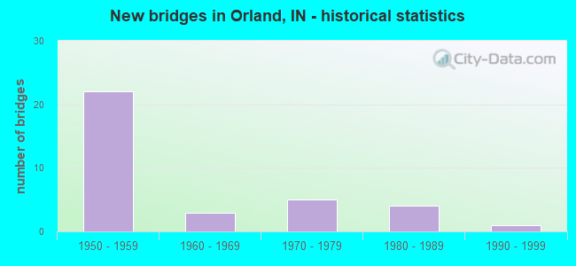
- New bridges - historical statistics
- 221950-1959
- 31960-1969
- 51970-1979
- 41980-1989
- 11990-1999

- Reconstructed bridges - Historical Statistics
- 21970-1979
- 41980-1989
- 11990-1999
- 42000-2009
- 22010-2019


- Bridge Condition - Deck
- 14.3%Very good
- 52.4%Good
- 14.3%Satisfactory
- 19.0%Fair

- Bridge Condition - Superstructure
- 9.5%Very good
- 33.3%Good
- 47.6%Satisfactory
- 9.5%Fair

- Bridge Condition - Substructure
- 4.8%Very good
- 47.6%Good
- 42.9%Satisfactory
- 4.8%Poor

- Bridge Condition - Channel
- 20.0%Very good
- 46.7%Good
- 33.3%Satisfactory

- Bridge Condition - Culverts
- 50.0%Satisfactory
- 50.0%Fair
Find on map >> Show street view
Structure Number: 486, Location: 00.20 E I-69 (Lat: 40.553539, Lng: -85.546881), Route carried "on" structure: State highway 18, Year Built: 1993, Status: Open, Structure Length: 2.41m (7.91ft), Average Daily Traffic: 2,715 (year 2016), Truck Traffic: 12%, Average Future Daily Traffic: 4,027 (year 2030), Design Load: HS 20, Features Intersected: TIPPEY DITCH
Minimum Vertical Clearance: 30+ m (98+ ft), Kilometerpoint: 28.131, Lanes on structure: 2, Owner: State Highway Agency, Approaching Roadway Width: 10.4m (34.1ft), Material/Design: Concrete continuous, Design/Construction: Slab, Number Of Spans In Main Unit: 3, Length of Maximum Span: 8.8m (28.9ft), Curb-To-Curb Width: 12.4m (40.7ft), Out-to-Out Width: 13.4m (44.0ft)
Condition: Deck: Fair, Superstructure: Fair, Substructure: Good, Channel: Good, Operating Rating: 37.6 metric tons, Method Used To Determine Operating Rating: Load and Resistance Factor Rating (LRFR) rating reported by rating factor(RF) method using HL-93 loadings, Inventory Rating: 29.2 metric tons, Method Used To Determine Inventory Rating: Load and Resistance Factor Rating (LRFR) rating reported by rating factor(RF) method using HL-93 loadings, Structural Evaluation: Somewhat better than minimum adequacy, Deck Geometry: Better than present minimum criteria, Waterway Adequacy: Equal to present desirable criteria, Approach Roadway Alignment: Equal to present desirable criteria, Designated Inspection Frequency: Every 24 months, Inspection Date: August 2021, Deck Structure Type: Concrete Cast-file-Place, Wearing Surface/Protective System: Wearing Surface: Monolithic Concrete, Deck Protection: Epoxy Coated Reinforcing
Find on map >> Show street view
Structure Number: 2591, Location: 00.93 E SR 327 (Lat: 41.734331, Lng: -85.154150), Route carried "on" structure: State highway 120, Year Built: 1977, Year Reconstructed: 2002, Status: Open, Structure Length: 3.03m (9.94ft), Average Daily Traffic: 3,012 (year 2021), Truck Traffic: 9%, Average Future Daily Traffic: 7,731 (year 2032), Design Load: HS 20, Features Intersected: CROOKED CREEK
Minimum Vertical Clearance: 30+ m (98+ ft), Kilometerpoint: 3.943, Lanes on structure: 2, Owner: State Highway Agency, Approaching Roadway Width: 12.2m (40.0ft), Material/Design: Prestressed concrete continuous, Design/Construction: Box Beam or Girders - Single/Spread, Number Of Spans In Main Unit: 3, Length of Maximum Span: 11.0m (36.1ft), Curb-To-Curb Width: 13.3m (43.6ft), Out-to-Out Width: 14.2m (46.6ft)
Condition: Deck: Good, Superstructure: Satisfactory, Substructure: Satisfactory, Channel: Very good, Operating Rating: 39.2 metric tons, Method Used To Determine Operating Rating: Load and Resistance Factor Rating (LRFR) rating reported by rating factor(RF) method using HL-93 loadings, Inventory Rating: 30.1 metric tons, Method Used To Determine Inventory Rating: Load and Resistance Factor Rating (LRFR) rating reported by rating factor(RF) method using HL-93 loadings, Structural Evaluation: Equal to present minimum criteria, Deck Geometry: Equal to present minimum criteria, Waterway Adequacy: Equal to present desirable criteria, Approach Roadway Alignment: Equal to present minimum criteria, Designated Inspection Frequency: Every 24 months, Inspection Date: April 2022, Deck Structure Type: Concrete Cast-file-Place, Wearing Surface/Protective System: Wearing Surface: Latex Concrete, Deck Protection: Epoxy Coated Reinforcing
Find on map >> Show street view
Structure Number: 3139, Location: 00.69 N SR 120 (Lat: 41.740281, Lng: -85.171461), Route carried "on" structure: State highway 327, Year Built: 1984, Year Reconstructed: 2018, Status: Open, Structure Length: 1.94m (6.36ft), Average Daily Traffic: 838 (year 2020), Truck Traffic: 12%, Average Future Daily Traffic: 1,680 (year 2038), Design Load: HS 20, Features Intersected: FAWN RIVER - SOUTH X-ING
Minimum Vertical Clearance: 30+ m (98+ ft), Kilometerpoint: 24.060, Lanes on structure: 2, Owner: State Highway Agency, Approaching Roadway Width: 13.3m (43.6ft), Material/Design: Concrete continuous, Design/Construction: Slab, Number Of Spans In Main Unit: 3, Length of Maximum Span: 7.3m (24.0ft), Curb-To-Curb Width: 13.3m (43.6ft), Out-to-Out Width: 14.2m (46.6ft)
Condition: Deck: Very good, Superstructure: Very good, Substructure: Satisfactory, Channel: Good, Operating Rating: 35.0 metric tons, Method Used To Determine Operating Rating: Load and Resistance Factor Rating (LRFR) rating reported by rating factor(RF) method using HL-93 loadings, Inventory Rating: 27.2 metric tons, Method Used To Determine Inventory Rating: Load and Resistance Factor Rating (LRFR) rating reported by rating factor(RF) method using HL-93 loadings, Structural Evaluation: Equal to present minimum criteria, Deck Geometry: Superior to present desirable criteria, Waterway Adequacy: Equal to present desirable criteria, Approach Roadway Alignment: Equal to present desirable criteria, Designated Inspection Frequency: Every 24 months, Inspection Date: April 2021, Deck Structure Type: Concrete Cast-file-Place, Wearing Surface/Protective System: Wearing Surface: Latex Concrete, Deck Protection: Epoxy Coated Reinforcing
Find on map >> Show street view
Structure Number: 314, Location: 00.76 N SR 120 (Lat: 41.741481, Lng: -85.171481), Route carried "on" structure: State highway 327, Year Built: 1984, Year Reconstructed: 2018, Status: Open, Structure Length: 2.59m (8.50ft), Average Daily Traffic: 838 (year 2020), Truck Traffic: 12%, Average Future Daily Traffic: 1,680 (year 2038), Design Load: HS 20, Features Intersected: FAWN RIVER - NORTH X-ING
Minimum Vertical Clearance: 30+ m (98+ ft), Kilometerpoint: 24.172, Lanes on structure: 2, Owner: State Highway Agency, Approaching Roadway Width: 13.3m (43.6ft), Skew: 3 degrees, Material/Design: Concrete continuous, Design/Construction: Slab, Number Of Spans In Main Unit: 3, Length of Maximum Span: 9.8m (32.2ft), Curb-To-Curb Width: 13.3m (43.6ft), Out-to-Out Width: 14.2m (46.6ft)
Condition: Deck: Very good, Superstructure: Very good, Substructure: Very good, Channel: Good, Operating Rating: 36.0 metric tons, Method Used To Determine Operating Rating: Load and Resistance Factor Rating (LRFR) rating reported by rating factor(RF) method using HL-93 loadings, Inventory Rating: 27.9 metric tons, Method Used To Determine Inventory Rating: Load and Resistance Factor Rating (LRFR) rating reported by rating factor(RF) method using HL-93 loadings, Structural Evaluation: Better than present minimum criteria, Deck Geometry: Superior to present desirable criteria, Waterway Adequacy: Equal to present desirable criteria, Approach Roadway Alignment: Equal to present desirable criteria, Designated Inspection Frequency: Every 24 months, Inspection Date: April 2021, Deck Structure Type: Concrete Cast-file-Place, Wearing Surface/Protective System: Wearing Surface: Latex Concrete, Deck Protection: Epoxy Coated Reinforcing
Find on map >> Show street view
Structure Number: 4857, Location: 03.03 W SR 327 (Lat: 41.755050, Lng: -85.230750), Route carried "on" structure: Interstate 90, Year Built: 1956, Year Reconstructed: 1988, Status: Open, Structure Length: 5.52m (18.11ft), Average Daily Traffic: 12,233 (year 2004), Truck Traffic: 10%, Average Future Daily Traffic: 23,502 (year 2031), Design Load: HS 20, Features Intersected: FAWN RIVER (EAST)
Minimum Vertical Clearance: 30+ m (98+ ft), Kilometerpoint: 211.484, Lanes on structure: 2, Base Highway Network: Yes (, Subroute: 1), Toll: On toll road, Owner: State Toll Authority, Approaching Roadway Width: 12.8m (42.0ft), Skew: 3 degrees, Material/Design: Steel, Design/Construction: Stringer/Multi-beam, Number Of Spans In Main Unit: 2, Length of Maximum Span: 22.3m (73.2ft), Curb-To-Curb Width: 9.8m (32.2ft), Out-to-Out Width: 10.7m (35.1ft)
Condition: Deck: Fair, Superstructure: Satisfactory, Substructure: Satisfactory, Channel: Very good, Operating Rating: 51.6 metric tons, Method Used To Determine Operating Rating: Load Factor (LF), Inventory Rating: 30.9 metric tons, Method Used To Determine Inventory Rating: Load Factor (LF), Structural Evaluation: Equal to present minimum criteria, Deck Geometry: High priority of replacement, Waterway Adequacy: Better than present minimum criteria, Approach Roadway Alignment: Equal to present desirable criteria, Designated Inspection Frequency: Every 24 months, Other Special Inspection Frequency: Every 24 months, Inspection Date: September 2021, Other Special Inspection Date: September 2021, Deck Structure Type: Concrete Cast-file-Place, Wearing Surface/Protective System: Wearing Surface: Latex Concrete
Find on map >> Show street view
Structure Number: 4858, Location: 03.03 W SR 327 (Lat: 41.755211, Lng: -85.231072), Route carried "on" structure: Interstate 90, Year Built: 1956, Year Reconstructed: 1988, Status: Open, Structure Length: 5.52m (18.11ft), Average Daily Traffic: 12,233 (year 2004), Truck Traffic: 10%, Average Future Daily Traffic: 23,502 (year 2031), Design Load: HS 20, Features Intersected: FAWN RIVER (EAST)
Minimum Vertical Clearance: 30+ m (98+ ft), Kilometerpoint: 211.484, Lanes on structure: 2, Base Highway Network: Yes (, Subroute: 1), Toll: On toll road, Owner: State Toll Authority, Approaching Roadway Width: 12.8m (42.0ft), Skew: 3 degrees, Material/Design: Steel, Design/Construction: Stringer/Multi-beam, Number Of Spans In Main Unit: 2, Length of Maximum Span: 22.3m (73.2ft), Curb-To-Curb Width: 9.8m (32.2ft), Out-to-Out Width: 10.7m (35.1ft)
Condition: Deck: Satisfactory, Superstructure: Satisfactory, Substructure: Satisfactory, Channel: Very good, Operating Rating: 51.6 metric tons, Method Used To Determine Operating Rating: Load Factor (LF), Inventory Rating: 30.9 metric tons, Method Used To Determine Inventory Rating: Load Factor (LF), Structural Evaluation: Equal to present minimum criteria, Deck Geometry: High priority of replacement, Waterway Adequacy: Better than present minimum criteria, Approach Roadway Alignment: Equal to present desirable criteria, Designated Inspection Frequency: Every 24 months, Other Special Inspection Frequency: Every 24 months, Inspection Date: September 2021, Other Special Inspection Date: September 2021, Deck Structure Type: Concrete Cast-file-Place, Wearing Surface/Protective System: Wearing Surface: Latex Concrete
Find on map >> Show street view
Structure Number: 4859, Location: 02.74 W SR 327 (Lat: 41.756331, Lng: -85.225472), Route carried "on" structure: Alternate County highway 1050, Year Built: 1956, Year Reconstructed: 2000, Status: Open, Structure Length: 6.58m (21.59ft), Average Daily Traffic: 131 (year 2004), Truck Traffic: 10%, Average Future Daily Traffic: 250 (year 2031), Design Load: HS 20, Features Intersected: I-90 EB/WB
Minimum Vertical Clearance: 30+ m (98+ ft), Kilometerpoint: 211.951, Lanes on structure: 2, Lanes under structure: 4, Owner: State Toll Authority, Approaching Roadway Width: 9.5m (31.2ft), Skew: 1 degrees, Material/Design: Steel, Design/Construction: Stringer/Multi-beam, Number Of Spans In Main Unit: 4, Length of Maximum Span: 20.5m (67.3ft), Curb-To-Curb Width: 8.2m (26.9ft), Out-to-Out Width: 9.1m (29.9ft)
Condition: Deck: Good, Superstructure: Satisfactory, Substructure: Good, Operating Rating: 92.9 metric tons, Method Used To Determine Operating Rating: Load Factor (LF), Inventory Rating: 55.6 metric tons, Method Used To Determine Inventory Rating: Load Factor (LF), Structural Evaluation: Equal to present minimum criteria, Deck Geometry: Somewhat better than minimum adequacy, Underclear: Somewhat better than minimum adequacy, Approach Roadway Alignment: Equal to present minimum criteria, Designated Inspection Frequency: Every 24 months, Other Special Inspection Frequency: Every 24 months, Inspection Date: September 2021, Other Special Inspection Date: September 2021, Deck Structure Type: Concrete Cast-file-Place, Wearing Surface/Protective System: Wearing Surface: Monolithic Concrete, Deck Protection: Epoxy Coated Reinforcing
Find on map >> Show street view
Structure Number: 486, Location: 02.14 W SR 327 (Lat: 41.756700, Lng: -85.215492), Route carried "on" structure: County highway , Year Built: 1956, Year Reconstructed: 2000, Status: Open, Structure Length: 6.49m (21.29ft), Average Daily Traffic: 77 (year 2015), Truck Traffic: 10%, Average Future Daily Traffic: 327 (year 2031), Design Load: HS 20, Features Intersected: I-90 EB/WB, Facility Carried by Structure: CR 1100E
Minimum Vertical Clearance: 30+ m (98+ ft), Kilometerpoint: 0.000, Lanes on structure: 2, Lanes under structure: 4, Owner: State Toll Authority, Approaching Roadway Width: 9.5m (31.2ft), Material/Design: Steel, Design/Construction: Stringer/Multi-beam, Number Of Spans In Main Unit: 4, Length of Maximum Span: 20.0m (65.6ft), Curb-To-Curb Width: 8.2m (26.9ft), Out-to-Out Width: 9.1m (29.9ft)
Condition: Deck: Good, Superstructure: Satisfactory, Substructure: Good, Operating Rating: 88.5 metric tons, Method Used To Determine Operating Rating: Load Factor (LF), Inventory Rating: 53.0 metric tons, Method Used To Determine Inventory Rating: Load Factor (LF), Structural Evaluation: Equal to present minimum criteria, Deck Geometry: Equal to present minimum criteria, Underclear: Somewhat better than minimum adequacy, Approach Roadway Alignment: Equal to present minimum criteria, Designated Inspection Frequency: Every 24 months, Other Special Inspection Frequency: Every 12 months, Inspection Date: September 2021, Other Special Inspection Date: September 2021, Deck Structure Type: Concrete Cast-file-Place, Wearing Surface/Protective System: Wearing Surface: Monolithic Concrete, Deck Protection: Epoxy Coated Reinforcing
Find on map >> Show street view
Structure Number: 4861, Location: 09.25 W I-69 (Lat: 41.755761, Lng: -85.172439), Route carried "on" structure: Interstate 90, Year Built: 1956, Year Reconstructed: 1983, Status: Open, Structure Length: 4.69m (15.39ft), Average Daily Traffic: 10,435 (year 2011), Truck Traffic: 14%, Average Future Daily Traffic: 25,681 (year 2031), Design Load: HS 20, Features Intersected: SR 327
Minimum Vertical Clearance: 30+ m (98+ ft), Kilometerpoint: 216.360, Lanes on structure: 2, Lanes under structure: 2, Base Highway Network: Yes (, Subroute: 1), Toll: On toll road, Owner: State Toll Authority, Approaching Roadway Width: 12.8m (42.0ft), Skew: 2 degrees, Material/Design: Steel, Design/Construction: Stringer/Multi-beam, Number Of Spans In Main Unit: 3, Length of Maximum Span: 16.2m (53.1ft), Curb-To-Curb Width: 9.8m (32.2ft), Out-to-Out Width: 10.7m (35.1ft)
Condition: Deck: Fair, Superstructure: Satisfactory, Substructure: Satisfactory, Operating Rating: 71.9 metric tons, Method Used To Determine Operating Rating: Load Factor (LF), Inventory Rating: 43.0 metric tons, Method Used To Determine Inventory Rating: Load Factor (LF), Structural Evaluation: Equal to present minimum criteria, Deck Geometry: High priority of replacement, Underclear: Equal to present minimum criteria, Approach Roadway Alignment: Equal to present desirable criteria, Designated Inspection Frequency: Every 24 months, Other Special Inspection Frequency: Every 24 months, Inspection Date: September 2021, Other Special Inspection Date: September 2021, Deck Structure Type: Concrete Cast-file-Place, Wearing Surface/Protective System: Wearing Surface: Latex Concrete
Find on map >> Show street view
Structure Number: 4862, Location: 09.25 W I-69 (Lat: 41.755981, Lng: -85.172600), Route carried "on" structure: Interstate 90, Year Built: 1956, Year Reconstructed: 1983, Status: Open, Structure Length: 4.69m (15.39ft), Average Daily Traffic: 10,435 (year 2011), Truck Traffic: 14%, Average Future Daily Traffic: 25,681 (year 2031), Design Load: HS 20, Features Intersected: SR 327
Minimum Vertical Clearance: 30+ m (98+ ft), Kilometerpoint: 216.360, Lanes on structure: 2, Lanes under structure: 2, Base Highway Network: Yes (, Subroute: 1), Toll: On toll road, Owner: State Toll Authority, Approaching Roadway Width: 12.8m (42.0ft), Skew: 2 degrees, Material/Design: Steel, Design/Construction: Stringer/Multi-beam, Number Of Spans In Main Unit: 3, Length of Maximum Span: 16.2m (53.1ft), Curb-To-Curb Width: 9.8m (32.2ft), Out-to-Out Width: 10.7m (35.1ft)
Condition: Deck: Satisfactory, Superstructure: Satisfactory, Substructure: Good, Operating Rating: 71.9 metric tons, Method Used To Determine Operating Rating: Load Factor (LF), Inventory Rating: 43.0 metric tons, Method Used To Determine Inventory Rating: Load Factor (LF), Structural Evaluation: Equal to present minimum criteria, Deck Geometry: High priority of replacement, Underclear: Somewhat better than minimum adequacy, Approach Roadway Alignment: Equal to present desirable criteria, Designated Inspection Frequency: Every 24 months, Other Special Inspection Frequency: Every 24 months, Inspection Date: September 2021, Other Special Inspection Date: September 2021, Deck Structure Type: Concrete Cast-file-Place, Wearing Surface/Protective System: Wearing Surface: Latex Concrete
Find on map >> Show street view
Structure Number: 4863, Location: 01.05 E SR 327 (Lat: 41.755650, Lng: -85.152275), Route carried "on" structure: County highway , Year Built: 1956, Year Reconstructed: 2000, Status: Open, Structure Length: 6.52m (21.39ft), Average Daily Traffic: 50 (year 2014), Truck Traffic: 10%, Average Future Daily Traffic: 211 (year 2031), Design Load: HS 20, Features Intersected: I-90 EB/WB, Facility Carried by Structure: CR 850W
Minimum Vertical Clearance: 30+ m (98+ ft), Kilometerpoint: 217.905, Lanes on structure: 2, Lanes under structure: 4, Owner: State Toll Authority, Approaching Roadway Width: 9.1m (29.9ft), Material/Design: Steel, Design/Construction: Stringer/Multi-beam, Number Of Spans In Main Unit: 4, Length of Maximum Span: 19.7m (64.6ft), Curb-To-Curb Width: 8.2m (26.9ft), Out-to-Out Width: 9.1m (29.9ft)
Condition: Deck: Very good, Superstructure: Satisfactory, Substructure: Good, Operating Rating: 84.7 metric tons, Method Used To Determine Operating Rating: Load Factor (LF), Inventory Rating: 50.7 metric tons, Method Used To Determine Inventory Rating: Load Factor (LF), Structural Evaluation: Equal to present minimum criteria, Deck Geometry: Equal to present minimum criteria, Underclear: Somewhat better than minimum adequacy, Approach Roadway Alignment: Equal to present desirable criteria, Designated Inspection Frequency: Every 24 months, Other Special Inspection Frequency: Every 24 months, Inspection Date: September 2021, Other Special Inspection Date: September 2021, Deck Structure Type: Concrete Cast-file-Place, Wearing Surface/Protective System: Wearing Surface: Monolithic Concrete, Deck Protection: Epoxy Coated Reinforcing
Find on map >> Show street view
Structure Number: 4864, Location: 01.55 E SR 327 (Lat: 41.755550, Lng: -85.142533), Route carried "on" structure: County highway 800, Year Built: 1956, Year Reconstructed: 2000, Status: Open, Structure Length: 6.52m (21.39ft), Average Daily Traffic: 65 (year 2014), Truck Traffic: 10%, Average Future Daily Traffic: 245 (year 2031), Design Load: HS 20, Features Intersected: I-90 EB/WB
Minimum Vertical Clearance: 30+ m (98+ ft), Kilometerpoint: 218.710, Lanes on structure: 2, Lanes under structure: 4, Owner: State Toll Authority, Approaching Roadway Width: 9.8m (32.2ft), Material/Design: Steel, Design/Construction: Stringer/Multi-beam, Number Of Spans In Main Unit: 4, Length of Maximum Span: 19.7m (64.6ft), Curb-To-Curb Width: 8.2m (26.9ft), Out-to-Out Width: 9.1m (29.9ft)
Condition: Deck: Good, Superstructure: Satisfactory, Substructure: Good, Operating Rating: 84.6 metric tons, Method Used To Determine Operating Rating: Load Factor (LF), Inventory Rating: 50.7 metric tons, Method Used To Determine Inventory Rating: Load Factor (LF), Structural Evaluation: Equal to present minimum criteria, Deck Geometry: Equal to present minimum criteria, Underclear: Somewhat better than minimum adequacy, Approach Roadway Alignment: Equal to present desirable criteria, Designated Inspection Frequency: Every 24 months, Other Special Inspection Frequency: Every 24 months, Inspection Date: September 2021, Other Special Inspection Date: September 2021, Deck Structure Type: Concrete Cast-file-Place, Wearing Surface/Protective System: Wearing Surface: Monolithic Concrete, Deck Protection: Epoxy Coated Reinforcing
Find on map >> Show street view
Structure Number: 4865, Location: 03.08 E SR 327 (Lat: 41.752661, Lng: -85.113472), Route carried "on" structure: Interstate 90, Year Built: 1956, Year Reconstructed: 1991, Status: Open, Structure Length: 3.66m (12.01ft), Average Daily Traffic: 10,435 (year 2011), Truck Traffic: 14%, Average Future Daily Traffic: 25,681 (year 2031), Design Load: HS 20, Features Intersected: CR 650 W
Minimum Vertical Clearance: 30+ m (98+ ft), Kilometerpoint: 221.317, Lanes on structure: 2, Lanes under structure: 2, Base Highway Network: Yes (, Subroute: 1), Toll: On toll road, Owner: State Toll Authority, Approaching Roadway Width: 12.8m (42.0ft), Skew: 1 degrees, Material/Design: Steel continuous, Design/Construction: Stringer/Multi-beam, Number Of Spans In Main Unit: 3, Length of Maximum Span: 10.7m (35.1ft), Curb-To-Curb Width: 13.8m (45.3ft), Out-to-Out Width: 14.7m (48.2ft)
Condition: Deck: Good, Superstructure: Good, Substructure: Satisfactory, Operating Rating: 74.8 metric tons, Method Used To Determine Operating Rating: Load Factor (LF), Inventory Rating: 44.8 metric tons, Method Used To Determine Inventory Rating: Load Factor (LF), Structural Evaluation: Equal to present minimum criteria, Deck Geometry: Superior to present desirable criteria, Underclear: High priority of corrective action, Approach Roadway Alignment: Equal to present desirable criteria, Designated Inspection Frequency: Every 24 months, Other Special Inspection Frequency: Every 24 months, Inspection Date: September 2021, Other Special Inspection Date: September 2021, Deck Structure Type: Concrete Cast-file-Place, Wearing Surface/Protective System: Wearing Surface: Latex Concrete
Find on map >> Show street view
Structure Number: 4866, Location: 03.08 E SR 327 (Lat: 41.752889, Lng: -85.113486), Route carried "on" structure: Interstate 90, Year Built: 1956, Year Reconstructed: 1991, Status: Open, Structure Length: 3.66m (12.01ft), Average Daily Traffic: 10,435 (year 2011), Truck Traffic: 14%, Average Future Daily Traffic: 25,681 (year 2031), Design Load: HS 20, Features Intersected: CR 650 W
Minimum Vertical Clearance: 30+ m (98+ ft), Kilometerpoint: 221.317, Lanes on structure: 2, Lanes under structure: 2, Base Highway Network: Yes (, Subroute: 1), Toll: On toll road, Owner: State Toll Authority, Approaching Roadway Width: 12.8m (42.0ft), Skew: 1 degrees, Material/Design: Steel continuous, Design/Construction: Stringer/Multi-beam, Number Of Spans In Main Unit: 3, Length of Maximum Span: 10.7m (35.1ft), Curb-To-Curb Width: 13.8m (45.3ft), Out-to-Out Width: 14.7m (48.2ft)
Condition: Deck: Good, Superstructure: Good, Substructure: Satisfactory, Operating Rating: 74.8 metric tons, Method Used To Determine Operating Rating: Load Factor (LF), Inventory Rating: 44.8 metric tons, Method Used To Determine Inventory Rating: Load Factor (LF), Structural Evaluation: Equal to present minimum criteria, Deck Geometry: Superior to present desirable criteria, Underclear: High priority of corrective action, Approach Roadway Alignment: Equal to present desirable criteria, Designated Inspection Frequency: Every 24 months, Other Special Inspection Frequency: Every 24 months, Inspection Date: September 2021, Other Special Inspection Date: September 2021, Deck Structure Type: Concrete Cast-file-Place, Wearing Surface/Protective System: Wearing Surface: Latex Concrete
Find on map >> Show street view
Structure Number: 4400035, Location: 00.50 N OF CR 150N (Lat: 41.670781, Lng: -85.195081), Route carried "on" structure: County highway 93, Year Built: 1975, Status: Open, Structure Length: 1.91m (6.27ft), Average Daily Traffic: 100 (year 2021), Truck Traffic: 3%, Average Future Daily Traffic: 150 (year 2041), Design Load: HS 20, Features Intersected: PIGEON CREEK, Facility Carried by Structure: CR 1200 EAST
Minimum Vertical Clearance: 30+ m (98+ ft), Kilometerpoint: 0.000, Lanes on structure: 2, Owner: County Highway Agency, Approaching Roadway Width: 5.5m (18.0ft), Material/Design: Concrete continuous, Design/Construction: Slab, Number Of Spans In Main Unit: 3, Length of Maximum Span: 7.3m (24.0ft), Curb-To-Curb Width: 8.4m (27.6ft), Out-to-Out Width: 8.5m (27.9ft)
Condition: Deck: Good, Superstructure: Good, Substructure: Satisfactory, Channel: Satisfactory, Operating Rating: 32.7 metric tons, Method Used To Determine Operating Rating: Field evaluation and documented engineering judgment, Inventory Rating: 32.7 metric tons, Method Used To Determine Inventory Rating: Field evaluation and documented engineering judgment, Structural Evaluation: Equal to present minimum criteria, Deck Geometry: Equal to present minimum criteria, Waterway Adequacy: Better than present minimum criteria, Approach Roadway Alignment: Equal to present desirable criteria, Designated Inspection Frequency: Every 24 months, Inspection Date: November 2021, Deck Structure Type: Concrete Cast-file-Place, Wearing Surface/Protective System: Wearing Surface: Monolithic Concrete
Find on map >> Show street view
Structure Number: 4400038, Location: 00.05 S OF CR 730N (Lat: 41.747519, Lng: -85.214689), Route carried "on" structure: County highway 91, Year Built: 1978, Status: Open, Structure Length: 1.45m (4.76ft), Average Daily Traffic: 275 (year 2021), Truck Traffic: 3%, Average Future Daily Traffic: 400 (year 2041), Design Load: HS 20, Features Intersected: FAWN RIVER, Facility Carried by Structure: CR 1100 EAST
Minimum Vertical Clearance: 30+ m (98+ ft), Kilometerpoint: 0.000, Lanes on structure: 2, Owner: County Highway Agency, Approaching Roadway Width: 5.5m (18.0ft), Navigation Control: Yes ( Vertical Clearance: 1.2m (3.9ft), Horizontal Clearance: 13.1m (43.0ft)), Material/Design: Prestressed concrete, Design/Construction: Box Beam or Girders - Multiple, Number Of Spans In Main Unit: 1, Length of Maximum Span: 13.1m (43.0ft), Curb-To-Curb Width: 7.2m (23.6ft), Out-to-Out Width: 7.4m (24.3ft)
Condition: Deck: Satisfactory, Superstructure: Satisfactory, Substructure: Satisfactory, Channel: Satisfactory, Operating Rating: 46.5 metric tons, Method Used To Determine Operating Rating: Load Factor (LF), Inventory Rating: 27.9 metric tons, Method Used To Determine Inventory Rating: Load Factor (LF), Structural Evaluation: Equal to present minimum criteria, Deck Geometry: Meets minimum limits, Waterway Adequacy: Better than present minimum criteria, Approach Roadway Alignment: Equal to present minimum criteria, Designated Inspection Frequency: Every 24 months, Inspection Date: November 2021, Deck Structure Type: Concrete Precast Panels, Wearing Surface/Protective System: Wearing Surface: Bituminous
Find on map >> Show street view
Structure Number: 4400039, Location: 00.10 E OF CR 1050E (Lat: 41.750950, Lng: -85.223661), Route carried "on" structure: County highway 230, Year Built: 1981, Status: Open, Structure Length: 1.28m (4.20ft), Average Daily Traffic: 100 (year 2021), Truck Traffic: 3%, Average Future Daily Traffic: 150 (year 2041), Design Load: HS 20, Features Intersected: FAWN RIVER, Facility Carried by Structure: CR 750 NORTH
Minimum Vertical Clearance: 30+ m (98+ ft), Kilometerpoint: 0.000, Lanes on structure: 2, Owner: County Highway Agency, Approaching Roadway Width: 6.7m (22.0ft), Navigation Control: Yes ( Vertical Clearance: 0.6m (2.0ft), Horizontal Clearance: 2.0m (6.6ft)), Material/Design: Steel, Design/Construction: Culvert, Number Of Spans In Main Unit: 5, Length of Maximum Span: 2.0m (6.6ft), Curb-To-Curb Width: 11.1m (36.4ft), Out-to-Out Width: 12.3m (40.4ft)
Condition: Channel: Satisfactory, Culverts: Fair, Structural Evaluation: Somewhat better than minimum adequacy, Deck Geometry: Superior to present desirable criteria, Waterway Adequacy: Equal to present desirable criteria, Approach Roadway Alignment: Equal to present minimum criteria, Designated Inspection Frequency: Every 24 months, Inspection Date: November 2021, Wearing Surface/Protective System: Wearing Surface: Bituminous
Find on map >> Show street view
Structure Number: 440004, Location: 00.13 N OF CR 750N (Lat: 41.752531, Lng: -85.225400), Route carried "on" structure: County highway 255, Year Built: 1984, Status: Posted for load, Structure Length: 1.89m (6.20ft), Average Daily Traffic: 125 (year 2021), Truck Traffic: 3%, Average Future Daily Traffic: 200 (year 2021), Design Load: HS 20, Features Intersected: FAWN RIVER, Facility Carried by Structure: CR 1050 EAST
Minimum Vertical Clearance: 30+ m (98+ ft), Kilometerpoint: 0.000, Lanes on structure: 2, Owner: County Highway Agency, Approaching Roadway Width: 6.7m (22.0ft), Navigation Control: Yes ( Vertical Clearance: 4.0m (13.1ft), Horizontal Clearance: 7.6m (24.9ft)), Material/Design: Wood or Timber, Design/Construction: Slab, Number Of Spans In Main Unit: 3, Length of Maximum Span: 7.9m (25.9ft), Curb or Sidewalk Widths: Left: 0.2m (0.7ft), Right: 0.2m (0.7ft), Curb-To-Curb Width: 7.4m (24.3ft), Out-to-Out Width: 7.8m (25.6ft)
Condition: Deck: Good, Superstructure: Good, Substructure: Good, Channel: Good, Operating Rating: 36.6 metric tons, Method Used To Determine Operating Rating: Load and Resistance Factor (LRFR), Inventory Rating: 28.4 metric tons, Method Used To Determine Inventory Rating: Load and Resistance Factor (LRFR), Structural Evaluation: Better than present minimum criteria, Deck Geometry: Somewhat better than minimum adequacy, Waterway Adequacy: Better than present minimum criteria, Approach Roadway Alignment: Equal to present desirable criteria, Designated Inspection Frequency: Every 24 months, Inspection Date: November 2021, Deck Structure Type: Wood or Timber, Wearing Surface/Protective System: Wearing Surface: Bituminous, Deck Protection: Internally Sealed
Find on map >> Show street view
Structure Number: 7600011, Location: 0.30 MILES S OF SR 120 (Lat: 41.739169, Lng: -85.103450), Route carried "on" structure: Alternate County highway 21, Year Built: 1965, Status: Open, Structure Length: 1.11m (3.64ft), Average Daily Traffic: 166 (year 2021), Truck Traffic: 3%, Average Future Daily Traffic: 232 (year 2041), Features Intersected: CROOKED CREEK, Facility Carried by Structure: CR 600W
Minimum Vertical Clearance: 30+ m (98+ ft), Kilometerpoint: 0.000, Lanes on structure: 2, Owner: County Highway Agency, Approaching Roadway Width: 6.1m (20.0ft), Material/Design: Steel, Design/Construction: Culvert, Number Of Spans In Main Unit: 3, Length of Maximum Span: 3.4m (11.2ft), Curb-To-Curb Width: 8.3m (27.2ft), Out-to-Out Width: 8.3m (27.2ft)
Condition: Channel: Satisfactory, Culverts: Satisfactory, Operating Rating: 39.9 metric tons, Method Used To Determine Operating Rating: Field evaluation and documented engineering judgment, Inventory Rating: 29.0 metric tons, Method Used To Determine Inventory Rating: Field evaluation and documented engineering judgment, Structural Evaluation: Equal to present minimum criteria, Deck Geometry: Somewhat better than minimum adequacy, Waterway Adequacy: Somewhat better than minimum adequacy, Approach Roadway Alignment: Equal to present desirable criteria, Designated Inspection Frequency: Every 24 months, Inspection Date: October 2021
Find on map >> Show street view
Structure Number: 7600029, Location: 0.20 MILES E OF CR 1100 W (Lat: 41.667500, Lng: -85.191339), Route carried "on" structure: Alternate County highway 164, Year Built: 1974, Status: Open, Structure Length: 1.91m (6.27ft), Average Daily Traffic: 40 (year 2021), Average Future Daily Traffic: 56 (year 2041), Design Load: HS 20, Features Intersected: PIGEON CREEK, Facility Carried by Structure: CR 175N
Minimum Vertical Clearance: 30+ m (98+ ft), Kilometerpoint: 0.000, Lanes on structure: 2, Owner: County Highway Agency, Approaching Roadway Width: 5.2m (17.1ft), Material/Design: Concrete continuous, Design/Construction: Slab, Number Of Spans In Main Unit: 3, Length of Maximum Span: 7.3m (24.0ft), Curb-To-Curb Width: 8.4m (27.6ft), Out-to-Out Width: 8.5m (27.9ft)
Condition: Deck: Good, Superstructure: Good, Substructure: Good, Channel: Satisfactory, Operating Rating: 50.8 metric tons, Method Used To Determine Operating Rating: Load Factor (LF), Inventory Rating: 30.2 metric tons, Method Used To Determine Inventory Rating: Load Factor (LF), Structural Evaluation: Better than present minimum criteria, Deck Geometry: Equal to present minimum criteria, Waterway Adequacy: Better than present minimum criteria, Approach Roadway Alignment: Equal to present desirable criteria, Designated Inspection Frequency: Every 24 months, Inspection Date: October 2021, Deck Structure Type: Concrete Cast-file-Place, Wearing Surface/Protective System: Wearing Surface: Monolithic Concrete
Find on map >> Show street view
Structure Number: 7600031, Location: 0.30 MILES S OF SR 120 (Lat: 41.734439, Lng: -85.142039), Route carried "on" structure: Alternate County highway 7, Year Built: 1966, Status: Open, Structure Length: 1.36m (4.46ft), Average Daily Traffic: 158 (year 2021), Truck Traffic: 3%, Average Future Daily Traffic: 221 (year 2041), Design Load: H 20, Features Intersected: CROOKED CREEK, Facility Carried by Structure: CR 800W
Minimum Vertical Clearance: 30+ m (98+ ft), Kilometerpoint: 0.000, Lanes on structure: 2, Owner: County Highway Agency, Approaching Roadway Width: 6.4m (21.0ft), Material/Design: Prestressed concrete, Design/Construction: Stringer/Multi-beam, Number Of Spans In Main Unit: 1, Length of Maximum Span: 13.0m (42.7ft), Curb-To-Curb Width: 8.4m (27.6ft), Out-to-Out Width: 8.5m (27.9ft)
Condition: Deck: Good, Superstructure: Good, Substructure: Good, Channel: Good, Operating Rating: 56.2 metric tons, Method Used To Determine Operating Rating: Load Factor (LF), Inventory Rating: 33.4 metric tons, Method Used To Determine Inventory Rating: Load Factor (LF), Structural Evaluation: Better than present minimum criteria, Deck Geometry: Somewhat better than minimum adequacy, Waterway Adequacy: Equal to present minimum criteria, Approach Roadway Alignment: Equal to present desirable criteria, Designated Inspection Frequency: Every 24 months, Inspection Date: October 2021, Deck Structure Type: Concrete Cast-file-Place, Wearing Surface/Protective System: Wearing Surface: Bituminous
Find on map >> Show street view
Structure Number: 7600032, Location: 0.30 MILES S OF SR 120 (Lat: 41.736111, Lng: -85.132389), Route carried "on" structure: Alternate County highway 107, Year Built: 1978, Status: Open, Structure Length: 1.91m (6.27ft), Average Daily Traffic: 126 (year 2021), Truck Traffic: 5%, Average Future Daily Traffic: 176 (year 2041), Design Load: HS 20, Features Intersected: CROOKED CREEK, Facility Carried by Structure: CR 750W
Minimum Vertical Clearance: 30+ m (98+ ft), Kilometerpoint: 0.000, Lanes on structure: 2, Owner: County Highway Agency, Approaching Roadway Width: 4.3m (14.1ft), Material/Design: Concrete continuous, Design/Construction: Slab, Number Of Spans In Main Unit: 3, Length of Maximum Span: 7.3m (24.0ft), Curb-To-Curb Width: 8.4m (27.6ft), Out-to-Out Width: 8.5m (27.9ft)
Condition: Deck: Good, Superstructure: Good, Substructure: Good, Channel: Good, Operating Rating: 50.8 metric tons, Method Used To Determine Operating Rating: Load Factor (LF), Inventory Rating: 30.2 metric tons, Method Used To Determine Inventory Rating: Load Factor (LF), Structural Evaluation: Better than present minimum criteria, Deck Geometry: Somewhat better than minimum adequacy, Waterway Adequacy: Better than present minimum criteria, Approach Roadway Alignment: Equal to present desirable criteria, Designated Inspection Frequency: Every 24 months, Inspection Date: October 2021, Deck Structure Type: Concrete Cast-file-Place, Wearing Surface/Protective System: Wearing Surface: Monolithic Concrete
Find on map >> Show street view
Structure Number: 7600033, Location: 0.40 MILES S OF SR 120 (Lat: 41.735281, Lng: -85.117939), Route carried "on" structure: Alternate County highway 121, Year Built: 1967, Status: Posted for load, Structure Length: 1.22m (4.00ft), Average Daily Traffic: 431 (year 2021), Truck Traffic: 3%, Average Future Daily Traffic: 602 (year 2041), Design Load: H 20, Features Intersected: CROOKED CREEK, Facility Carried by Structure: CR 675W
Minimum Vertical Clearance: 30+ m (98+ ft), Kilometerpoint: 0.000, Lanes on structure: 2, Owner: County Highway Agency, Approaching Roadway Width: 6.7m (22.0ft), Material/Design: Prestressed concrete, Design/Construction: Box Beam or Girders - Multiple, Number Of Spans In Main Unit: 1, Length of Maximum Span: 11.9m (39.0ft), Curb-To-Curb Width: 8.6m (28.2ft), Out-to-Out Width: 9.2m (30.2ft)
Condition: Deck: Fair, Superstructure: Fair, Substructure: Poor, Channel: Good, Operating Rating: 36.2 metric tons, Method Used To Determine Operating Rating: Field evaluation and documented engineering judgment, Inventory Rating: 21.6 metric tons, Method Used To Determine Inventory Rating: Field evaluation and documented engineering judgment, Structural Evaluation: Meets minimum limits, Deck Geometry: Somewhat better than minimum adequacy, Waterway Adequacy: Better than present minimum criteria, Approach Roadway Alignment: Equal to present desirable criteria, Bridge Posting: Required (Relationship of Operating Rating to Maximum Legal Load: 20.0 - 29.9% below), Length Of Structure Improvement: 1.89m (6.20ft), Designated Inspection Frequency: Every 12 months, Inspection Date: October 2021, Bridge Improvement Cost: $324,000, Roadway Improvement Cost: $360,000, Total Project Cost: $684,000 ( Estimate for 2021), Deck Structure Type: Concrete Precast Panels, Wearing Surface/Protective System: Wearing Surface: Bituminous
Find on map >> Show street view
Structure Number: 4859, Location: 02.74 W SR 327 (Lat: 41.756331, Lng: -85.225472), Route carried "under" structure: Interstate 90, Year Built: 1956, Structure Length: 0. m, Average Daily Traffic: 10,456 (year 2011), Truck Traffic: 40%, Features Intersected: CR 1050E
Minimum Vertical Clearance: 4.95m (16.24ft), Kilometerpoint: 211.951, Lanes on structure: 2, Lanes under structure: 2, Toll: On toll road, Material/Design: Steel, Design/Construction: Stringer/Multi-beam, Length of Maximum Span: 20.5m (67.3ft)
Find on map >> Show street view
Structure Number: 4859, Location: 02.74 W SR 327 (Lat: 41.756331, Lng: -85.225472), Route carried "under" structure: Interstate 90, Year Built: 1956, Structure Length: 0. m, Average Daily Traffic: 10,456 (year 2011), Truck Traffic: 24%, Features Intersected: CR 1050E
Minimum Vertical Clearance: 4.95m (16.24ft), Kilometerpoint: 211.951, Lanes on structure: 2, Lanes under structure: 2, Toll: On toll road, Material/Design: Steel, Design/Construction: Stringer/Multi-beam, Length of Maximum Span: 20.5m (67.3ft)
Find on map >> Show street view
Structure Number: 486, Location: 02.14 W SR 327 (Lat: 41.756700, Lng: -85.215492), Route carried "under" structure: Interstate 90, Year Built: 1956, Structure Length: 0. m, Average Daily Traffic: 11,010 (year 2015), Truck Traffic: 24%, Features Intersected: I-90 EB, Facility Carried by Structure: CR 1100E
Minimum Vertical Clearance: 4.88m (16.01ft), Kilometerpoint: 212.916, Lanes on structure: 2, Lanes under structure: 2, Toll: On toll road, Material/Design: Steel, Design/Construction: Stringer/Multi-beam, Length of Maximum Span: 20.0m (65.6ft)
Find on map >> Show street view
Structure Number: 486, Location: 02.14 W SR 327 (Lat: 41.756700, Lng: -85.215492), Route carried "under" structure: Interstate 90, Year Built: 1956, Structure Length: 0. m, Average Daily Traffic: 11,010 (year 2015), Truck Traffic: 24%, Features Intersected: I-90 WB, Facility Carried by Structure: CR 1100E
Minimum Vertical Clearance: 4.88m (16.01ft), Kilometerpoint: 212.916, Lanes on structure: 2, Lanes under structure: 2, Toll: On toll road, Material/Design: Steel, Design/Construction: Stringer/Multi-beam, Length of Maximum Span: 20.0m (65.6ft)
Find on map >> Show street view
Structure Number: 4861, Location: 09.25 W I-69 (Lat: 41.755761, Lng: -85.172439), Route carried "under" structure: State highway 327, Year Built: 1956, Structure Length: 0. m, Average Daily Traffic: 1,169 (year 2004), Truck Traffic: 10%, Features Intersected: SR 327, Facility Carried by Structure: I-90 EB
Minimum Vertical Clearance: 4.80m (15.75ft), Kilometerpoint: 25.782, Lanes on structure: 2, Lanes under structure: 2, Material/Design: Steel, Design/Construction: Stringer/Multi-beam, Length of Maximum Span: 16.2m (53.1ft)
Find on map >> Show street view
Structure Number: 4862, Location: 09.25 W I-69 (Lat: 41.755981, Lng: -85.172600), Route carried "under" structure: State highway 327, Year Built: 1956, Structure Length: 0. m, Average Daily Traffic: 1,169 (year 2004), Truck Traffic: 10%, Features Intersected: SR 327, Facility Carried by Structure: I-90 WB
Minimum Vertical Clearance: 4.37m (14.34ft), Kilometerpoint: 25.798, Lanes on structure: 2, Lanes under structure: 2, Material/Design: Steel, Design/Construction: Stringer/Multi-beam, Length of Maximum Span: 16.2m (53.1ft)
Find on map >> Show street view
Structure Number: 4863, Location: 01.05 E SR 327 (Lat: 41.755650, Lng: -85.152275), Route carried "under" structure: Interstate 90, Year Built: 1956, Structure Length: 0. m, Average Daily Traffic: 11,010 (year 2014), Truck Traffic: 10%, Features Intersected: I-90 WB, Facility Carried by Structure: CR 850W
Minimum Vertical Clearance: 4.60m (15.09ft), Kilometerpoint: 218.050, Lanes on structure: 2, Lanes under structure: 2, Toll: On toll road, Material/Design: Steel, Design/Construction: Stringer/Multi-beam, Length of Maximum Span: 19.7m (64.6ft)
Find on map >> Show street view
Structure Number: 4863, Location: 01.05 E SR 327 (Lat: 41.755650, Lng: -85.152275), Route carried "under" structure: Interstate 90, Year Built: 1956, Structure Length: 0. m, Average Daily Traffic: 11,010 (year 2014), Truck Traffic: 10%, Features Intersected: I-90 EB, Facility Carried by Structure: CR 850W
Minimum Vertical Clearance: 4.85m (15.91ft), Kilometerpoint: 218.050, Lanes on structure: 2, Lanes under structure: 2, Toll: On toll road, Material/Design: Steel, Design/Construction: Stringer/Multi-beam, Length of Maximum Span: 19.7m (64.6ft)
Find on map >> Show street view
Structure Number: 4864, Location: 01.55 E SR 327 (Lat: 41.755550, Lng: -85.142533), Route carried "under" structure: Interstate 90, Year Built: 1956, Structure Length: 0. m, Average Daily Traffic: 11,010 (year 2014), Truck Traffic: 10%, Features Intersected: I-90 WB, Facility Carried by Structure: CR 800W
Minimum Vertical Clearance: 4.88m (16.01ft), Kilometerpoint: 218.855, Lanes on structure: 2, Lanes under structure: 2, Toll: On toll road, Material/Design: Steel, Design/Construction: Stringer/Multi-beam, Length of Maximum Span: 19.7m (64.6ft)
Find on map >> Show street view
Structure Number: 4864, Location: 01.55 E SR 327 (Lat: 41.755550, Lng: -85.142533), Route carried "under" structure: Interstate 90, Year Built: 1956, Structure Length: 0. m, Average Daily Traffic: 11,010 (year 2014), Truck Traffic: 10%, Features Intersected: I-90 EB, Facility Carried by Structure: CR 800W
Minimum Vertical Clearance: 4.88m (16.01ft), Kilometerpoint: 218.855, Lanes on structure: 2, Lanes under structure: 2, Toll: On toll road, Material/Design: Steel, Design/Construction: Stringer/Multi-beam, Length of Maximum Span: 19.7m (64.6ft)
Find on map >> Show street view
Structure Number: 4865, Location: 03.08 E SR 327 (Lat: 41.752661, Lng: -85.113472), Route carried "under" structure: County highway , Year Built: 1956, Structure Length: 0. m, Average Daily Traffic: 602 (year 2004), Truck Traffic: 10%, Features Intersected: CR 650W, Facility Carried by Structure: I-90 EB
Minimum Vertical Clearance: 4.06m (13.32ft), Kilometerpoint: 0.000, Lanes on structure: 2, Lanes under structure: 2, Toll: On toll road, Material/Design: Steel continuous, Design/Construction: Stringer/Multi-beam, Length of Maximum Span: 10.7m (35.1ft)
Find on map >> Show street view
Structure Number: 4866, Location: 03.08 E SR 327 (Lat: 41.752889, Lng: -85.113486), Route carried "under" structure: County highway , Year Built: 1956, Structure Length: 0. m, Average Daily Traffic: 602 (year 2004), Truck Traffic: 10%, Features Intersected: CR 650 W, Facility Carried by Structure: I-90 WB
Minimum Vertical Clearance: 4.12m (13.52ft), Kilometerpoint: 0.000, Lanes on structure: 2, Lanes under structure: 2, Toll: On toll road, Material/Design: Steel continuous, Design/Construction: Stringer/Multi-beam, Length of Maximum Span: 10.7m (35.1ft)