Bridge Statistics for Orrville, Ohio (OH)
Condition, Traffic, Stress, Structural Evaluation, Project Costs
- National Bridge Inventory (NBI) Statistics
- 38Number of bridges
- 312ft / 95.2mTotal length
- $515,000Total costs
- 167,132Total average daily traffic
- 24,986Total average daily truck traffic
- National Bridge Inventory (NBI) Registered Bridges for Orrville
- No street view available for this location
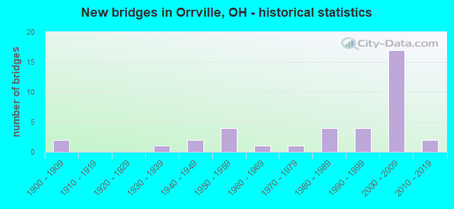
- New bridges - historical statistics
- 21900-1909
- 11930-1939
- 21940-1949
- 41950-1959
- 11960-1969
- 11970-1979
- 41980-1989
- 41990-1999
- 172000-2009
- 22010-2019

- Reconstructed bridges - Historical Statistics
- 11960-1969
- 01970-1979
- 31980-1989
- 11990-1999
- 22000-2009
- 12010-2019


- Bridge Condition - Deck
- 20.7%Excellent
- 37.9%Very good
- 27.6%Good
- 10.3%Satisfactory
- 3.4%Fair

- Bridge Condition - Superstructure
- 24.1%Excellent
- 37.9%Very good
- 24.1%Good
- 13.8%Satisfactory

- Bridge Condition - Substructure
- 27.6%Excellent
- 27.6%Very good
- 17.2%Good
- 20.7%Satisfactory
- 3.4%Fair
- 3.4%Poor

- Bridge Condition - Channel
- 16.7%Very good
- 50.0%Good
- 25.0%Satisfactory
- 4.2%Fair
- 4.2%Poor
Find on map >> Show street view
Structure Number: 8502153, Location: 1.11 MI.E.OF CR-44 (Lat: 40.805369, Lng: -81.824169), Route carried "on" structure: County highway C0416, Year Built: 2005, Status: Open, Structure Length: 5.66m (18.57ft), Average Daily Traffic: 71 (year 2015), Truck Traffic: 7%, Average Future Daily Traffic: 24,588 (year 2035), Design Load: HS 25 or greater, Features Intersected: WAY-30-1662 (NEW US30), Facility Carried by Structure: CR 416 MCQUAID RD
Minimum Vertical Clearance: 30+ m (98+ ft), Kilometerpoint: 2.012, Lanes on structure: 2, Lanes under structure: 4, Owner: State Highway Agency, Approaching Roadway Width: 9.1m (29.9ft), Skew: 1 degrees, Material/Design: Steel continuous, Design/Construction: Stringer/Multi-beam, Number Of Spans In Main Unit: 2, Length of Maximum Span: 28.0m (91.9ft), Curb-To-Curb Width: 9.1m (29.9ft), Out-to-Out Width: 10.1m (33.1ft)
Condition: Deck: Very good, Superstructure: Very good, Substructure: Very good, Operating Rating: 42.1 metric tons, Method Used To Determine Operating Rating: Load Factor (LF) rating reported by rating factor (RF) method using MS18 loading, Inventory Rating: 32.4 metric tons, Method Used To Determine Inventory Rating: Load Factor (LF) rating reported by rating factor (RF) method using MS18 loading, Structural Evaluation: Equal to present desirable criteria, Deck Geometry: Better than present minimum criteria, Underclear: Equal to present desirable criteria, Approach Roadway Alignment: Equal to present minimum criteria, Designated Inspection Frequency: Every 24 months, Inspection Date: November 2020, Deck Structure Type: Concrete Cast-file-Place, Wearing Surface/Protective System: Wearing Surface: Monolithic Concrete, Deck Protection: Epoxy Coated Reinforcing
Find on map >> Show street view
Structure Number: 8502234, Location: 0.63 MI. WEST OF S.R.57 (Lat: 40.796311, Lng: -81.777539), Route carried "on" structure: City street M0476, Year Built: 2007, Status: Open, Structure Length: 5.61m (18.41ft), Average Daily Traffic: 239 (year 2015), Truck Traffic: 8%, Average Future Daily Traffic: 28,201 (year 2035), Design Load: HS 25 or greater, Features Intersected: WAY.-30- 19.52, Facility Carried by Structure: TR-179(KANSASRDEXT
Minimum Vertical Clearance: 30+ m (98+ ft), Kilometerpoint: 0.241, Lanes on structure: 2, Lanes under structure: 4, Owner: State Highway Agency, Approaching Roadway Width: 8.5m (27.9ft), Skew: 1 degrees, Material/Design: Steel continuous, Design/Construction: Stringer/Multi-beam, Number Of Spans In Main Unit: 2, Length of Maximum Span: 27.7m (90.9ft), Curb-To-Curb Width: 8.5m (27.9ft), Out-to-Out Width: 9.4m (30.8ft)
Condition: Deck: Very good, Superstructure: Very good, Substructure: Very good, Operating Rating: 42.1 metric tons, Method Used To Determine Operating Rating: Load Factor (LF) rating reported by rating factor (RF) method using MS18 loading, Inventory Rating: 32.4 metric tons, Method Used To Determine Inventory Rating: Load Factor (LF) rating reported by rating factor (RF) method using MS18 loading, Structural Evaluation: Equal to present desirable criteria, Deck Geometry: Equal to present minimum criteria, Underclear: Meets minimum limits, Approach Roadway Alignment: Equal to present minimum criteria, Designated Inspection Frequency: Every 24 months, Inspection Date: November 2020, Deck Structure Type: Concrete Cast-file-Place, Wearing Surface/Protective System: Wearing Surface: Monolithic Concrete, Deck Protection: Epoxy Coated Reinforcing
Find on map >> Show street view
Structure Number: 8502269, Location: 2.01 MI.E.OF C.R.44 (Lat: 40.796011, Lng: -81.811369), Route carried "on" structure: US 30, Year Built: 2005, Status: Open, Structure Length: 6.05m (19.85ft), Average Daily Traffic: 8,858 (year 2015), Truck Traffic: 17%, Average Future Daily Traffic: 12,295 (year 2035), Design Load: HS 25 or greater, Features Intersected: C.R.30A (E.LINCOLN WAY)
Minimum Vertical Clearance: 30+ m (98+ ft), Kilometerpoint: 28.228, Lanes on structure: 2, Lanes under structure: 2, Base Highway Network: Yes, Owner: State Highway Agency, Approaching Roadway Width: 12.2m (40.0ft), Skew: 4 degrees, Material/Design: Steel continuous, Design/Construction: Stringer/Multi-beam, Number Of Spans In Main Unit: 2, Length of Maximum Span: 31.7m (104.0ft), Curb-To-Curb Width: 12.8m (42.0ft), Out-to-Out Width: 13.7m (44.9ft)
Condition: Deck: Very good, Superstructure: Very good, Substructure: Very good, Channel: Good, Operating Rating: 42.1 metric tons, Method Used To Determine Operating Rating: Load and Resistance Factor Rating (LRFR) rating reported by rating factor(RF) method using HL-93 loadings, Inventory Rating: 32.4 metric tons, Method Used To Determine Inventory Rating: Load and Resistance Factor Rating (LRFR) rating reported by rating factor(RF) method using HL-93 loadings, Structural Evaluation: Equal to present desirable criteria, Deck Geometry: Equal to present desirable criteria, Underclear: Better than present minimum criteria, Waterway Adequacy: Superior to present desirable criteria, Approach Roadway Alignment: Better than present minimum criteria, Designated Inspection Frequency: Every 24 months, Inspection Date: November 2020, Deck Structure Type: Concrete Cast-file-Place, Wearing Surface/Protective System: Wearing Surface: Monolithic Concrete, Deck Protection: Epoxy Coated Reinforcing
Find on map >> Show street view
Structure Number: 8502277, Location: 2.01 MI.E.OF C.R.44 (Lat: 40.795881, Lng: -81.811689), Route carried "on" structure: US 30, Year Built: 2005, Status: Open, Structure Length: 3.32m (10.89ft), Average Daily Traffic: 8,858 (year 2015), Truck Traffic: 17%, Average Future Daily Traffic: 12,295 (year 2035), Design Load: HS 25 or greater, Features Intersected: C.R.30A (E.LINCOLN WAY)
Minimum Vertical Clearance: 30+ m (98+ ft), Kilometerpoint: 28.228, Lanes on structure: 2, Lanes under structure: 2, Base Highway Network: Yes, Owner: State Highway Agency, Approaching Roadway Width: 12.2m (40.0ft), Skew: 4 degrees, Material/Design: Steel, Design/Construction: Stringer/Multi-beam, Number Of Spans In Main Unit: 1, Length of Maximum Span: 33.2m (108.9ft), Curb-To-Curb Width: 12.8m (42.0ft), Out-to-Out Width: 13.7m (44.9ft)
Condition: Deck: Very good, Superstructure: Excellent, Substructure: Very good, Channel: Good, Operating Rating: 42.1 metric tons, Method Used To Determine Operating Rating: Load and Resistance Factor Rating (LRFR) rating reported by rating factor(RF) method using HL-93 loadings, Inventory Rating: 32.4 metric tons, Method Used To Determine Inventory Rating: Load and Resistance Factor Rating (LRFR) rating reported by rating factor(RF) method using HL-93 loadings, Structural Evaluation: Equal to present desirable criteria, Deck Geometry: Equal to present desirable criteria, Underclear: Better than present minimum criteria, Waterway Adequacy: Superior to present desirable criteria, Approach Roadway Alignment: Better than present minimum criteria, Designated Inspection Frequency: Every 24 months, Inspection Date: November 2020, Deck Structure Type: Concrete Cast-file-Place, Wearing Surface/Protective System: Wearing Surface: Monolithic Concrete, Deck Protection: Epoxy Coated Reinforcing
Find on map >> Show street view
Structure Number: 8502293, Location: 2.13 MI.W.OF SR 57 (Lat: 40.792050, Lng: -81.804581), Route carried "on" structure: US 30, Year Built: 2005, Status: Open, Structure Length: 4.20m (13.78ft), Average Daily Traffic: 8,858 (year 2015), Truck Traffic: 17%, Average Future Daily Traffic: 12,295 (year 2035), Design Load: HS 25 or greater, Features Intersected: T.R.145 (SWINEHART RD.)
Minimum Vertical Clearance: 30+ m (98+ ft), Kilometerpoint: 28.968, Lanes on structure: 2, Lanes under structure: 2, Base Highway Network: Yes, Owner: State Highway Agency, Approaching Roadway Width: 12.2m (40.0ft), Skew: 2 degrees, Material/Design: Steel continuous, Design/Construction: Stringer/Multi-beam, Number Of Spans In Main Unit: 3, Length of Maximum Span: 18.9m (62.0ft), Curb-To-Curb Width: 12.8m (42.0ft), Out-to-Out Width: 13.7m (44.9ft)
Condition: Deck: Very good, Superstructure: Very good, Substructure: Very good, Operating Rating: 42.1 metric tons, Method Used To Determine Operating Rating: Load Factor (LF) rating reported by rating factor (RF) method using MS18 loading, Inventory Rating: 32.4 metric tons, Method Used To Determine Inventory Rating: Load Factor (LF) rating reported by rating factor (RF) method using MS18 loading, Structural Evaluation: Equal to present desirable criteria, Deck Geometry: Equal to present desirable criteria, Underclear: Equal to present minimum criteria, Approach Roadway Alignment: Better than present minimum criteria, Designated Inspection Frequency: Every 24 months, Inspection Date: November 2020, Deck Structure Type: Concrete Cast-file-Place, Wearing Surface/Protective System: Wearing Surface: Monolithic Concrete, Deck Protection: Epoxy Coated Reinforcing
Find on map >> Show street view
Structure Number: 8502307, Location: 2.13 MI.W.OF S.R.57 (Lat: 40.792311, Lng: -81.804581), Route carried "on" structure: US 30, Year Built: 2005, Status: Open, Structure Length: 4.20m (13.78ft), Average Daily Traffic: 8,858 (year 2015), Truck Traffic: 17%, Average Future Daily Traffic: 12,295 (year 2035), Design Load: HS 25 or greater, Features Intersected: T.R.145 (SWINEHART RD.)
Minimum Vertical Clearance: 30+ m (98+ ft), Kilometerpoint: 28.968, Lanes on structure: 2, Lanes under structure: 2, Base Highway Network: Yes, Owner: State Highway Agency, Approaching Roadway Width: 12.2m (40.0ft), Skew: 2 degrees, Material/Design: Steel continuous, Design/Construction: Stringer/Multi-beam, Number Of Spans In Main Unit: 3, Length of Maximum Span: 18.9m (62.0ft), Curb-To-Curb Width: 12.8m (42.0ft), Out-to-Out Width: 13.7m (44.9ft)
Condition: Deck: Very good, Superstructure: Very good, Substructure: Very good, Operating Rating: 42.1 metric tons, Method Used To Determine Operating Rating: Load Factor (LF) rating reported by rating factor (RF) method using MS18 loading, Inventory Rating: 32.4 metric tons, Method Used To Determine Inventory Rating: Load Factor (LF) rating reported by rating factor (RF) method using MS18 loading, Structural Evaluation: Equal to present desirable criteria, Deck Geometry: Equal to present desirable criteria, Underclear: Better than present minimum criteria, Approach Roadway Alignment: Better than present minimum criteria, Designated Inspection Frequency: Every 24 months, Inspection Date: November 2020, Deck Structure Type: Concrete Cast-file-Place, Wearing Surface/Protective System: Wearing Surface: Monolithic Concrete, Deck Protection: Epoxy Coated Reinforcing
Find on map >> Show street view
Structure Number: 8502315, Location: 1.1 MI.W.OF S.R.57 (Lat: 40.793481, Lng: -81.785000), Route carried "on" structure: County highway C0094, Year Built: 2005, Status: Open, Structure Length: 6.42m (21.06ft), Average Daily Traffic: 1,765 (year 2015), Truck Traffic: 8%, Average Future Daily Traffic: 26,396 (year 2035), Design Load: HS 25 or greater, Features Intersected: WAY-30-1908 (NEW US30), Facility Carried by Structure: CR 94A CARR RD
Minimum Vertical Clearance: 30+ m (98+ ft), Kilometerpoint: 16.093, Lanes on structure: 2, Lanes under structure: 4, Owner: State Highway Agency, Approaching Roadway Width: 12.2m (40.0ft), Skew: 3 degrees, Material/Design: Steel continuous, Design/Construction: Stringer/Multi-beam, Number Of Spans In Main Unit: 2, Length of Maximum Span: 31.7m (104.0ft), Curb-To-Curb Width: 12.2m (40.0ft), Out-to-Out Width: 13.1m (43.0ft)
Condition: Deck: Very good, Superstructure: Very good, Substructure: Very good, Operating Rating: 42.1 metric tons, Method Used To Determine Operating Rating: Load Factor (LF) rating reported by rating factor (RF) method using MS18 loading, Inventory Rating: 32.4 metric tons, Method Used To Determine Inventory Rating: Load Factor (LF) rating reported by rating factor (RF) method using MS18 loading, Structural Evaluation: Equal to present desirable criteria, Deck Geometry: Better than present minimum criteria, Underclear: Equal to present desirable criteria, Approach Roadway Alignment: Equal to present minimum criteria, Designated Inspection Frequency: Every 24 months, Inspection Date: November 2020, Deck Structure Type: Concrete Cast-file-Place, Wearing Surface/Protective System: Wearing Surface: Monolithic Concrete, Deck Protection: Epoxy Coated Reinforcing
Find on map >> Show street view
Structure Number: 8502331, Location: 1.0 MI.W.OF S.R.57 (Lat: 40.794619, Lng: -81.782669), Route carried "on" structure: US 30, Year Built: 2005, Status: Open, Structure Length: 0.90m (2.95ft), Average Daily Traffic: 19,017 (year 2015), Truck Traffic: 19%, Average Future Daily Traffic: 26,396 (year 2035), Design Load: HS 20+Mod, Features Intersected: LITTLE SUGAR CREEK
Minimum Vertical Clearance: 30+ m (98+ ft), Kilometerpoint: 30.948, Lanes on structure: 6, Base Highway Network: Yes, Owner: State Highway Agency, Approaching Roadway Width: 38.4m (126.0ft), Skew: 2 degrees, Material/Design: Concrete, Design/Construction: Culvert, Number Of Spans In Main Unit: 1, Length of Maximum Span: 8.3m (27.2ft)
Condition: Channel: Poor, Culverts: Good, Operating Rating: 42.1 metric tons, Method Used To Determine Operating Rating: Load Factor (LF) rating reported by rating factor (RF) method using MS18 loading, Inventory Rating: 32.4 metric tons, Method Used To Determine Inventory Rating: Load Factor (LF) rating reported by rating factor (RF) method using MS18 loading, Structural Evaluation: Better than present minimum criteria, Waterway Adequacy: Superior to present desirable criteria, Approach Roadway Alignment: Equal to present desirable criteria, Designated Inspection Frequency: Every 24 months, Inspection Date: November 2021
Find on map >> Show street view
Structure Number: 8502587, Location: 1.05 MI N US 30 (Lat: 40.811969, Lng: -81.765381), Route carried "on" structure: State highway 57, Year Built: 1951, Year Reconstructed: 1996, Status: Open, Structure Length: 4.88m (16.01ft), Average Daily Traffic: 7,636 (year 2015), Truck Traffic: 14%, Average Future Daily Traffic: 10,599 (year 2035), Design Load: HS 25 or greater, Features Intersected: SUGAR CREEK
Minimum Vertical Clearance: 30+ m (98+ ft), Kilometerpoint: 1.690, Lanes on structure: 2, Base Highway Network: Yes, Owner: State Highway Agency, Approaching Roadway Width: 13.4m (44.0ft), Skew: 4 degrees, Material/Design: Steel continuous, Design/Construction: Stringer/Multi-beam, Number Of Spans In Main Unit: 3, Length of Maximum Span: 17.4m (57.1ft), Curb-To-Curb Width: 13.4m (44.0ft), Out-to-Out Width: 13.4m (44.0ft)
Condition: Deck: Very good, Superstructure: Very good, Substructure: Good, Channel: Good, Operating Rating: 42.1 metric tons, Method Used To Determine Operating Rating: Allowable Stress (AS) rating reported by rating factor (RF) method using MS18 loading, Inventory Rating: 32.4 metric tons, Method Used To Determine Inventory Rating: Allowable Stress (AS) rating reported by rating factor (RF) method using MS18 loading, Structural Evaluation: Better than present minimum criteria, Deck Geometry: Equal to present minimum criteria, Waterway Adequacy: Equal to present desirable criteria, Approach Roadway Alignment: Equal to present desirable criteria, Designated Inspection Frequency: Every 24 months, Inspection Date: November 2020, Deck Structure Type: Concrete Cast-file-Place, Wearing Surface/Protective System: Wearing Surface: Monolithic Concrete, Deck Protection: Epoxy Coated Reinforcing
Find on map >> Show street view
Structure Number: 8502617, Location: 4.32 MILES NORTH OF US30 (Lat: 40.859139, Lng: -81.763689), Route carried "on" structure: State highway 57, Year Built: 1955, Status: Open, Structure Length: 1.22m (4.00ft), Average Daily Traffic: 10,198 (year 2015), Truck Traffic: 12%, Average Future Daily Traffic: 14,155 (year 2035), Design Load: H 20, Features Intersected: LITTLE CHIPPEWA CREEK
Minimum Vertical Clearance: 30+ m (98+ ft), Kilometerpoint: 6.952, Lanes on structure: 2, Base Highway Network: Yes, Owner: State Highway Agency, Approaching Roadway Width: 9.1m (29.9ft), Skew: 2 degrees, Material/Design: Concrete continuous, Design/Construction: Slab, Number Of Spans In Main Unit: 3, Length of Maximum Span: 5.2m (17.1ft), Curb-To-Curb Width: 12.2m (40.0ft), Out-to-Out Width: 12.2m (40.0ft)
Condition: Deck: Good, Superstructure: Good, Substructure: Satisfactory, Channel: Good, Operating Rating: 51.8 metric tons, Method Used To Determine Operating Rating: Allowable Stress (AS) rating reported by rating factor (RF) method using MS18 loading, Inventory Rating: 29.2 metric tons, Method Used To Determine Inventory Rating: Allowable Stress (AS) rating reported by rating factor (RF) method using MS18 loading, Structural Evaluation: Equal to present minimum criteria, Deck Geometry: Somewhat better than minimum adequacy, Waterway Adequacy: Better than present minimum criteria, Approach Roadway Alignment: Better than present minimum criteria, Designated Inspection Frequency: Every 12 months, Inspection Date: November 2021, Deck Structure Type: Concrete Cast-file-Place, Wearing Surface/Protective System: Wearing Surface: Latex Concrete
Find on map >> Show street view
Structure Number: 8506019, Location: 3.56 MILES SOUTH OF SR 57 (Lat: 40.894231, Lng: -81.812700), Route carried "on" structure: State highway 585, Year Built: 1991, Status: Open, Structure Length: 3.02m (9.91ft), Average Daily Traffic: 9,130 (year 2015), Truck Traffic: 11%, Average Future Daily Traffic: 12,672 (year 2035), Design Load: HS 20, Features Intersected: LITTLE CHIPPEWA CREEK
Minimum Vertical Clearance: 30+ m (98+ ft), Kilometerpoint: 13.856, Lanes on structure: 2, Base Highway Network: Yes, Owner: State Highway Agency, Approaching Roadway Width: 12.2m (40.0ft), Skew: 1 degrees, Material/Design: Concrete continuous, Design/Construction: Slab, Number Of Spans In Main Unit: 3, Length of Maximum Span: 11.0m (36.1ft), Curb-To-Curb Width: 12.2m (40.0ft), Out-to-Out Width: 12.2m (40.0ft)
Condition: Deck: Good, Superstructure: Good, Substructure: Good, Channel: Good, Operating Rating: 42.1 metric tons, Method Used To Determine Operating Rating: Allowable Stress (AS) rating reported by rating factor (RF) method using MS18 loading, Inventory Rating: 32.4 metric tons, Method Used To Determine Inventory Rating: Allowable Stress (AS) rating reported by rating factor (RF) method using MS18 loading, Structural Evaluation: Better than present minimum criteria, Deck Geometry: Somewhat better than minimum adequacy, Waterway Adequacy: Superior to present desirable criteria, Approach Roadway Alignment: Better than present minimum criteria, Designated Inspection Frequency: Every 24 months, Inspection Date: November 2020, Deck Structure Type: Concrete Cast-file-Place, Wearing Surface/Protective System: Wearing Surface: Monolithic Concrete, Deck Protection: Epoxy Coated Reinforcing
Find on map >> Show street view
Structure Number: 8541213, Location: 0.3 MI. E. OF CR84 (Lat: 40.796981, Lng: -81.783139), Route carried "on" structure: County highway C030A, Year Built: 1935, Year Reconstructed: 2007, Status: Posted for load, Structure Length: 1.21m (3.97ft), Average Daily Traffic: 1,037 (year 2015), Truck Traffic: 6%, Average Future Daily Traffic: 1,439 (year 2035), Design Load: H 20, Features Intersected: LITTLE SUGAR CREEK, Facility Carried by Structure: COUNTY ROAD 30A
Minimum Vertical Clearance: 30+ m (98+ ft), Kilometerpoint: 7.998, Lanes on structure: 2, Owner: County Highway Agency, Approaching Roadway Width: 10.4m (34.1ft), Material/Design: Steel, Design/Construction: Stringer/Multi-beam, Number Of Spans In Main Unit: 1, Length of Maximum Span: 11.2m (36.7ft), Curb-To-Curb Width: 8.2m (26.9ft), Out-to-Out Width: 8.2m (26.9ft)
Condition: Deck: Very good, Superstructure: Very good, Substructure: Poor, Channel: Good, Operating Rating: 35.6 metric tons, Method Used To Determine Operating Rating: Load Factor (LF) rating reported by rating factor (RF) method using MS18 loading, Inventory Rating: 22.7 metric tons, Method Used To Determine Inventory Rating: Load Factor (LF) rating reported by rating factor (RF) method using MS18 loading, Structural Evaluation: Meets minimum limits, Deck Geometry: Meets minimum limits, Waterway Adequacy: Better than present minimum criteria, Approach Roadway Alignment: Equal to present desirable criteria, Bridge Posting: Required (Relationship of Operating Rating to Maximum Legal Load: 20.0 - 29.9% below), Designated Inspection Frequency: Every 12 months, Inspection Date: August 2021, Deck Structure Type: Wood or Timber, Wearing Surface/Protective System: Wearing Surface: Bituminous
Find on map >> Show street view
Structure Number: 8541582, Location: 0.5 MI. N. OF US30 (Lat: 40.802861, Lng: -81.784911), Route carried "on" structure: County highway C0084, Year Built: 1982, Status: Open, Structure Length: 1.68m (5.51ft), Average Daily Traffic: 595 (year 2015), Truck Traffic: 7%, Average Future Daily Traffic: 826 (year 2035), Design Load: HS 20, Features Intersected: LITTLE SUGAR CREEK, Facility Carried by Structure: COUNTY ROAD 84
Minimum Vertical Clearance: 30+ m (98+ ft), Kilometerpoint: 0.724, Lanes on structure: 2, Owner: County Highway Agency, Approaching Roadway Width: 6.7m (22.0ft), Skew: 4 degrees, Material/Design: Prestressed concrete, Design/Construction: Box Beam or Girders - Multiple, Number Of Spans In Main Unit: 1, Length of Maximum Span: 16.5m (54.1ft), Curb-To-Curb Width: 7.4m (24.3ft), Out-to-Out Width: 7.4m (24.3ft)
Condition: Deck: Good, Superstructure: Good, Substructure: Very good, Channel: Satisfactory, Operating Rating: 64.8 metric tons, Method Used To Determine Operating Rating: Load Factor (LF) rating reported by rating factor (RF) method using MS18 loading, Inventory Rating: 38.9 metric tons, Method Used To Determine Inventory Rating: Load Factor (LF) rating reported by rating factor (RF) method using MS18 loading, Structural Evaluation: Better than present minimum criteria, Deck Geometry: Meets minimum limits, Waterway Adequacy: Better than present minimum criteria, Approach Roadway Alignment: Better than present minimum criteria, Designated Inspection Frequency: Every 24 months, Inspection Date: August 2021, Deck Structure Type: Concrete Cast-file-Place, Wearing Surface/Protective System: Wearing Surface: Bituminous
Find on map >> Show street view
Structure Number: 8541639, Location: 0.2 MI. E. OF TR145 (Lat: 40.806950, Lng: -81.799100), Route carried "on" structure: County highway C0416, Year Built: 1991, Status: Open, Structure Length: 1.55m (5.09ft), Average Daily Traffic: 71 (year 2015), Truck Traffic: 7%, Average Future Daily Traffic: 99 (year 2035), Design Load: HS 20, Features Intersected: BRANCH OF SUGAR CREEK, Facility Carried by Structure: COUNTY ROAD 416
Minimum Vertical Clearance: 30+ m (98+ ft), Kilometerpoint: 3.991, Lanes on structure: 2, Owner: County Highway Agency, Approaching Roadway Width: 9.1m (29.9ft), Material/Design: Prestressed concrete, Design/Construction: Box Beam or Girders - Multiple, Number Of Spans In Main Unit: 1, Length of Maximum Span: 15.2m (49.9ft), Curb-To-Curb Width: 8.0m (26.2ft), Out-to-Out Width: 8.0m (26.2ft)
Condition: Deck: Good, Superstructure: Good, Substructure: Excellent, Channel: Satisfactory, Operating Rating: 68.0 metric tons, Method Used To Determine Operating Rating: Load Factor (LF) rating reported by rating factor (RF) method using MS18 loading, Inventory Rating: 42.1 metric tons, Method Used To Determine Inventory Rating: Load Factor (LF) rating reported by rating factor (RF) method using MS18 loading, Structural Evaluation: Better than present minimum criteria, Deck Geometry: Equal to present minimum criteria, Waterway Adequacy: Superior to present desirable criteria, Approach Roadway Alignment: Equal to present desirable criteria, Designated Inspection Frequency: Every 24 months, Inspection Date: August 2021, Deck Structure Type: Concrete Cast-file-Place, Wearing Surface/Protective System: Wearing Surface: Bituminous, Membrane: Preformed Fabric
Find on map >> Show street view
Structure Number: 8541736, Location: 0.4 MILE WEST OF TR145 (Lat: 40.795661, Lng: -81.811650), Route carried "on" structure: County highway C030A, Year Built: 1941, Year Reconstructed: 1987, Status: Open, Structure Length: 1.16m (3.81ft), Average Daily Traffic: 1,982 (year 2015), Truck Traffic: 6%, Average Future Daily Traffic: 2,751 (year 2035), Design Load: HS 20+Mod, Features Intersected: BRANCH OF SUGAR CREEK, Facility Carried by Structure: COUNTY ROAD 30A
Minimum Vertical Clearance: 30+ m (98+ ft), Kilometerpoint: 5.552, Lanes on structure: 2, Owner: County Highway Agency, Approaching Roadway Width: 37.2m (122.0ft), Skew: 5 degrees, Material/Design: Concrete, Design/Construction: Slab, Number Of Spans In Main Unit: 1, Length of Maximum Span: 11.0m (36.1ft), Curb-To-Curb Width: 21.2m (69.6ft), Out-to-Out Width: 21.9m (71.9ft)
Condition: Deck: Satisfactory, Superstructure: Satisfactory, Substructure: Fair, Channel: Fair, Operating Rating: 97.2 metric tons, Method Used To Determine Operating Rating: Load Factor (LF) rating reported by rating factor (RF) method using MS18 loading, Inventory Rating: 74.5 metric tons, Method Used To Determine Inventory Rating: Load Factor (LF) rating reported by rating factor (RF) method using MS18 loading, Structural Evaluation: Somewhat better than minimum adequacy, Deck Geometry: Superior to present desirable criteria, Waterway Adequacy: Equal to present minimum criteria, Approach Roadway Alignment: Equal to present desirable criteria, Designated Inspection Frequency: Every 12 months, Inspection Date: August 2021, Deck Structure Type: Concrete Cast-file-Place, Wearing Surface/Protective System: Wearing Surface: Monolithic Concrete, Deck Protection: Epoxy Coated Reinforcing
Find on map >> Show street view
Structure Number: 8541957, Location: 0.1 MILE WEST OF CR84 (Lat: 40.811100, Lng: -81.787411), Route carried "on" structure: County highway C0416, Year Built: 2013, Status: Open, Structure Length: 1.24m (4.07ft), Average Daily Traffic: 71 (year 2015), Truck Traffic: 7%, Average Future Daily Traffic: 99 (year 2035), Design Load: HL 93, Features Intersected: LITTLE SUGAR CREEK, Facility Carried by Structure: COUNTY ROAD 416
Minimum Vertical Clearance: 30+ m (98+ ft), Kilometerpoint: 5.150, Lanes on structure: 2, Owner: County Highway Agency, Approaching Roadway Width: 7.9m (25.9ft), Skew: 1 degrees, Material/Design: Concrete, Design/Construction: Slab, Number Of Spans In Main Unit: 1, Length of Maximum Span: 11.6m (38.1ft), Curb-To-Curb Width: 8.5m (27.9ft), Out-to-Out Width: 8.5m (27.9ft)
Condition: Deck: Excellent, Superstructure: Excellent, Substructure: Excellent, Channel: Very good, Operating Rating: 84.2 metric tons, Method Used To Determine Operating Rating: Load Factor (LF) rating reported by rating factor (RF) method using MS18 loading, Inventory Rating: 51.8 metric tons, Method Used To Determine Inventory Rating: Load Factor (LF) rating reported by rating factor (RF) method using MS18 loading, Structural Evaluation: Superior to present desirable criteria, Deck Geometry: Better than present minimum criteria, Waterway Adequacy: Superior to present desirable criteria, Approach Roadway Alignment: Equal to present desirable criteria, Designated Inspection Frequency: Every 24 months, Inspection Date: August 2021, Deck Structure Type: Concrete Cast-file-Place, Wearing Surface/Protective System: Wearing Surface: Monolithic Concrete, Deck Protection: Epoxy Coated Reinforcing
Find on map >> Show street view
Structure Number: 854498, Location: 1.2 MI. E. OF CR44 (Lat: 40.829900, Lng: -81.818931), Route carried "on" structure: County highway C0023, Year Built: 1941, Year Reconstructed: 1987, Status: Open, Structure Length: 1.57m (5.15ft), Average Daily Traffic: 7,781 (year 2015), Truck Traffic: 7%, Average Future Daily Traffic: 10,800 (year 2035), Design Load: HS 20, Features Intersected: SUGAR CREEK, Facility Carried by Structure: COUNTY ROAD 23
Minimum Vertical Clearance: 30+ m (98+ ft), Kilometerpoint: 4.908, Lanes on structure: 2, Owner: County Highway Agency, Approaching Roadway Width: 8.2m (26.9ft), Material/Design: Steel continuous, Design/Construction: Stringer/Multi-beam, Number Of Spans In Main Unit: 2, Length of Maximum Span: 7.6m (24.9ft), Curb-To-Curb Width: 7.3m (24.0ft), Out-to-Out Width: 7.3m (24.0ft)
Condition: Deck: Good, Superstructure: Good, Substructure: Satisfactory, Channel: Satisfactory, Operating Rating: 94.0 metric tons, Method Used To Determine Operating Rating: Load Factor (LF) rating reported by rating factor (RF) method using MS18 loading, Inventory Rating: 58.3 metric tons, Method Used To Determine Inventory Rating: Load Factor (LF) rating reported by rating factor (RF) method using MS18 loading, Structural Evaluation: Equal to present minimum criteria, Deck Geometry: High priority of replacement, Waterway Adequacy: Better than present minimum criteria, Approach Roadway Alignment: Equal to present minimum criteria, Length Of Structure Improvement: 2.23m (7.32ft), Designated Inspection Frequency: Every 12 months, Inspection Date: July 2021, Bridge Improvement Cost: $429,000, Roadway Improvement Cost: $43,000, Total Project Cost: $515,000, Deck Structure Type: Corrugated Steel, Wearing Surface/Protective System: Wearing Surface: Bituminous, Membrane: Preformed Fabric
Find on map >> Show street view
Structure Number: 8545111, Location: 0.5 MI. W. OF SR57 (Lat: 40.866631, Lng: -81.773481), Route carried "on" structure: County highway C0029, Year Built: 1955, Year Reconstructed: 2015, Status: Open, Structure Length: 1.08m (3.54ft), Average Daily Traffic: 2,564 (year 2015), Truck Traffic: 5%, Average Future Daily Traffic: 3,559 (year 2035), Design Load: HS 25 or greater, Features Intersected: LITTLE CHIPPEWA CREEK, Facility Carried by Structure: COUNTY ROAD 29
Minimum Vertical Clearance: 30+ m (98+ ft), Kilometerpoint: 7.741, Lanes on structure: 2, Owner: County Highway Agency, Approaching Roadway Width: 9.1m (29.9ft), Skew: 2 degrees, Material/Design: Steel, Design/Construction: Stringer/Multi-beam, Number Of Spans In Main Unit: 1, Length of Maximum Span: 10.5m (34.4ft), Curb-To-Curb Width: 7.3m (24.0ft), Out-to-Out Width: 7.6m (24.9ft)
Condition: Deck: Satisfactory, Superstructure: Very good, Substructure: Good, Channel: Good, Operating Rating: 81.0 metric tons, Method Used To Determine Operating Rating: Allowable Stress (AS) rating reported by rating factor (RF) method using MS18 loading, Inventory Rating: 58.3 metric tons, Method Used To Determine Inventory Rating: Allowable Stress (AS) rating reported by rating factor (RF) method using MS18 loading, Structural Evaluation: Better than present minimum criteria, Deck Geometry: High priority of replacement, Waterway Adequacy: Better than present minimum criteria, Approach Roadway Alignment: Equal to present minimum criteria, Designated Inspection Frequency: Every 12 months, Inspection Date: July 2021, Deck Structure Type: Wood or Timber, Wearing Surface/Protective System: Wearing Surface: Bituminous, Membrane: Other
Find on map >> Show street view
Structure Number: 8545146, Location: 0.5 MI. N. OF CR120 (Lat: 40.881319, Lng: -81.783581), Route carried "on" structure: County highway T0047, Year Built: 1900, Year Reconstructed: 1973, Status: Open, Structure Length: 1.40m (4.59ft), Average Daily Traffic: 456 (year 2015), Truck Traffic: 7%, Average Future Daily Traffic: 633 (year 2035), Design Load: HS 20, Features Intersected: LITTLE CHIPPEWA, Facility Carried by Structure: TWP. ROAD 47
Minimum Vertical Clearance: 30+ m (98+ ft), Kilometerpoint: 6.518, Lanes on structure: 1, Owner: County Highway Agency, Approaching Roadway Width: 9.8m (32.2ft), Material/Design: Prestressed concrete, Design/Construction: Box Beam or Girders - Multiple, Number Of Spans In Main Unit: 1, Length of Maximum Span: 13.4m (44.0ft), Curb-To-Curb Width: 4.6m (15.1ft), Out-to-Out Width: 4.6m (15.1ft)
Condition: Deck: Good, Superstructure: Good, Substructure: Satisfactory, Channel: Good, Operating Rating: 42.1 metric tons, Method Used To Determine Operating Rating: Load Factor (LF) rating reported by rating factor (RF) method using MS18 loading, Inventory Rating: 32.4 metric tons, Method Used To Determine Inventory Rating: Load Factor (LF) rating reported by rating factor (RF) method using MS18 loading, Structural Evaluation: Equal to present minimum criteria, Deck Geometry: High priority of replacement, Waterway Adequacy: Equal to present desirable criteria, Approach Roadway Alignment: Meets minimum limits, Designated Inspection Frequency: Every 12 months, Inspection Date: July 2021, Deck Structure Type: Concrete Cast-file-Place, Wearing Surface/Protective System: Wearing Surface: Bituminous
Find on map >> Show street view
Structure Number: 8545197, Location: 0.8 MI. E. OF SR57 (Lat: 40.873869, Lng: -81.779281), Route carried "on" structure: County highway C0120, Year Built: 1973, Status: Open, Structure Length: 1.34m (4.40ft), Average Daily Traffic: 716 (year 2015), Truck Traffic: 8%, Average Future Daily Traffic: 994 (year 2035), Design Load: HS 20, Features Intersected: LITTLE CHIPPEWA CREEK, Facility Carried by Structure: COUNTY ROAD 120
Minimum Vertical Clearance: 30+ m (98+ ft), Kilometerpoint: 5.311, Lanes on structure: 2, Owner: County Highway Agency, Approaching Roadway Width: 11.0m (36.1ft), Material/Design: Prestressed concrete, Design/Construction: Box Beam or Girders - Multiple, Number Of Spans In Main Unit: 1, Length of Maximum Span: 12.8m (42.0ft), Curb-To-Curb Width: 7.4m (24.3ft), Out-to-Out Width: 7.4m (24.3ft)
Condition: Deck: Good, Superstructure: Satisfactory, Substructure: Good, Channel: Satisfactory, Operating Rating: 55.1 metric tons, Method Used To Determine Operating Rating: Load Factor (LF) rating reported by rating factor (RF) method using MS18 loading, Inventory Rating: 32.4 metric tons, Method Used To Determine Inventory Rating: Load Factor (LF) rating reported by rating factor (RF) method using MS18 loading, Structural Evaluation: Equal to present minimum criteria, Deck Geometry: Meets minimum limits, Waterway Adequacy: Better than present minimum criteria, Approach Roadway Alignment: Better than present minimum criteria, Designated Inspection Frequency: Every 12 months, Inspection Date: July 2021, Deck Structure Type: Concrete Cast-file-Place, Wearing Surface/Protective System: Wearing Surface: Bituminous
Find on map >> Show street view
Structure Number: 8545219, Location: 0.5 MI. S. OF CR23 (Lat: 40.822511, Lng: -81.803589), Route carried "on" structure: County highway T0145, Year Built: 1905, Year Reconstructed: 2009, Status: Open, Structure Length: 1.27m (4.17ft), Average Daily Traffic: 410 (year 2015), Truck Traffic: 8%, Average Future Daily Traffic: 569 (year 2035), Design Load: HS 20, Features Intersected: SUGAR CREEK, Facility Carried by Structure: TWP. ROAD 145
Minimum Vertical Clearance: 30+ m (98+ ft), Kilometerpoint: 0.933, Lanes on structure: 1, Owner: County Highway Agency, Approaching Roadway Width: 4.3m (14.1ft), Skew: 1 degrees, Material/Design: Steel, Design/Construction: Girder and Floorbeam System, Number Of Spans In Main Unit: 1, Length of Maximum Span: 12.3m (40.4ft), Curb-To-Curb Width: 4.1m (13.5ft), Out-to-Out Width: 4.1m (13.5ft)
Condition: Deck: Very good, Superstructure: Good, Substructure: Satisfactory, Channel: Satisfactory, Operating Rating: 42.1 metric tons, Method Used To Determine Operating Rating: Allowable Stress (AS) rating reported by rating factor (RF) method using MS18 loading, Inventory Rating: 29.2 metric tons, Method Used To Determine Inventory Rating: Allowable Stress (AS) rating reported by rating factor (RF) method using MS18 loading, Structural Evaluation: Equal to present minimum criteria, Deck Geometry: High priority of replacement, Waterway Adequacy: Better than present minimum criteria, Approach Roadway Alignment: Equal to present desirable criteria, Designated Inspection Frequency: Every 12 months, Critical Feature Inspection Frequency: Every 24 months, Inspection Date: July 2021, Critical Feature Inspection Date: May 2020, Deck Structure Type: Wood or Timber, Wearing Surface/Protective System: Wearing Surface: Bituminous
Find on map >> Show street view
Structure Number: 8545227, Location: 300 FT. S. OF TR221 (Lat: 40.887700, Lng: -81.803411), Route carried "on" structure: County highway C0145, Year Built: 1955, Year Reconstructed: 1989, Status: Posted for load, Structure Length: 1.80m (5.91ft), Average Daily Traffic: 562 (year 2015), Truck Traffic: 7%, Average Future Daily Traffic: 780 (year 2035), Design Load: HS 20, Features Intersected: LITTLE CHIPPEWA, Facility Carried by Structure: COUNTY ROAD 145
Minimum Vertical Clearance: 30+ m (98+ ft), Kilometerpoint: 8.159, Lanes on structure: 2, Owner: County Highway Agency, Approaching Roadway Width: 5.5m (18.0ft), Skew: 2 degrees, Material/Design: Steel, Design/Construction: Girder and Floorbeam System, Number Of Spans In Main Unit: 1, Length of Maximum Span: 17.7m (58.1ft), Curb-To-Curb Width: 6.1m (20.0ft), Out-to-Out Width: 6.9m (22.6ft)
Condition: Deck: Good, Superstructure: Satisfactory, Substructure: Satisfactory, Channel: Good, Operating Rating: 16.2 metric tons, Method Used To Determine Operating Rating: Allowable Stress (AS) rating reported by rating factor (RF) method using MS18 loading, Inventory Rating: 9.7 metric tons, Method Used To Determine Inventory Rating: Allowable Stress (AS) rating reported by rating factor (RF) method using MS18 loading, Structural Evaluation: High priority of corrective action, Deck Geometry: High priority of corrective action, Waterway Adequacy: Equal to present desirable criteria, Approach Roadway Alignment: Equal to present desirable criteria, Bridge Posting: Required (Relationship of Operating Rating to Maximum Legal Load: > 39.9% below), Designated Inspection Frequency: Every 12 months, Critical Feature Inspection Frequency: Every 24 months, Inspection Date: July 2021, Critical Feature Inspection Date: July 2020, Deck Structure Type: Corrugated Steel, Wearing Surface/Protective System: Wearing Surface: Bituminous, Membrane: Preformed Fabric
Find on map >> Show street view
Structure Number: 8545278, Location: 0.8 MI. E. OF SR585 (Lat: 40.888650, Lng: -81.805150), Route carried "on" structure: County highway T0221, Year Built: 1962, Status: Posted for load, Structure Length: 3.21m (10.53ft), Average Daily Traffic: 353 (year 2015), Truck Traffic: 8%, Average Future Daily Traffic: 490 (year 2035), Design Load: H 15, Features Intersected: LITTLE CHIPPEWA, Facility Carried by Structure: TWP. ROAD 221
Minimum Vertical Clearance: 30+ m (98+ ft), Kilometerpoint: 6.148, Lanes on structure: 2, Owner: County Highway Agency, Approaching Roadway Width: 8.8m (28.9ft), Skew: 5 degrees, Material/Design: Steel, Design/Construction: Truss - Thru, Number Of Spans In Main Unit: 1, Length of Maximum Span: 30.5m (100.1ft), Curb-To-Curb Width: 6.9m (22.6ft), Out-to-Out Width: 7.4m (24.3ft)
Condition: Deck: Fair, Superstructure: Satisfactory, Substructure: Good, Channel: Good, Operating Rating: 35.6 metric tons, Method Used To Determine Operating Rating: Load Factor (LF) rating reported by rating factor (RF) method using MS18 loading, Inventory Rating: 22.7 metric tons, Method Used To Determine Inventory Rating: Load Factor (LF) rating reported by rating factor (RF) method using MS18 loading, Structural Evaluation: Equal to present minimum criteria, Deck Geometry: Meets minimum limits, Waterway Adequacy: Better than present minimum criteria, Approach Roadway Alignment: Equal to present desirable criteria, Bridge Posting: Required (Relationship of Operating Rating to Maximum Legal Load: 10.0 - 19.9% below), Designated Inspection Frequency: Every 12 months, Critical Feature Inspection Frequency: Every 24 months, Inspection Date: July 2021, Critical Feature Inspection Date: July 2020, Deck Structure Type: Corrugated Steel, Wearing Surface/Protective System: Wearing Surface: Bituminous
Find on map >> Show street view
Structure Number: 8545383, Location: 0.4 MI. S. OF CR7 (Lat: 40.816000, Lng: -81.780069), Route carried "on" structure: County highway C0416, Year Built: 1988, Status: Open, Structure Length: 1.83m (6.00ft), Average Daily Traffic: 71 (year 2015), Truck Traffic: 6%, Average Future Daily Traffic: 99 (year 2035), Design Load: HS 20, Features Intersected: LITTLE SUGAR CREEK, Facility Carried by Structure: COUNTY ROAD 416
Minimum Vertical Clearance: 30+ m (98+ ft), Kilometerpoint: 0.161, Lanes on structure: 2, Owner: County Highway Agency, Approaching Roadway Width: 8.5m (27.9ft), Skew: 2 degrees, Material/Design: Prestressed concrete, Design/Construction: Box Beam or Girders - Multiple, Number Of Spans In Main Unit: 1, Length of Maximum Span: 18.0m (59.1ft), Curb-To-Curb Width: 7.9m (25.9ft), Out-to-Out Width: 7.9m (25.9ft)
Condition: Deck: Excellent, Superstructure: Excellent, Substructure: Excellent, Channel: Satisfactory, Operating Rating: 71.3 metric tons, Method Used To Determine Operating Rating: Load Factor (LF) rating reported by rating factor (RF) method using MS18 loading, Inventory Rating: 42.1 metric tons, Method Used To Determine Inventory Rating: Load Factor (LF) rating reported by rating factor (RF) method using MS18 loading, Structural Evaluation: Superior to present desirable criteria, Deck Geometry: Equal to present minimum criteria, Waterway Adequacy: Better than present minimum criteria, Approach Roadway Alignment: Equal to present desirable criteria, Designated Inspection Frequency: Every 24 months, Inspection Date: July 2021, Deck Structure Type: Concrete Cast-file-Place, Wearing Surface/Protective System: Wearing Surface: Bituminous, Membrane: Built-up
Find on map >> Show street view
Structure Number: 8545405, Location: 0.3 MI. S. OF CR7 (Lat: 40.818500, Lng: -81.779689), Route carried "on" structure: County highway C0416, Year Built: 1994, Status: Open, Structure Length: 2.13m (6.99ft), Average Daily Traffic: 71 (year 2015), Truck Traffic: 6%, Average Future Daily Traffic: 99 (year 2035), Design Load: HS 20+Mod, Features Intersected: SUGAR CREEK, Facility Carried by Structure: COUNTY ROAD 416
Minimum Vertical Clearance: 30+ m (98+ ft), Kilometerpoint: 0.435, Lanes on structure: 2, Owner: County Highway Agency, Approaching Roadway Width: 7.9m (25.9ft), Material/Design: Prestressed concrete, Design/Construction: Box Beam or Girders - Multiple, Number Of Spans In Main Unit: 1, Length of Maximum Span: 21.0m (68.9ft), Curb-To-Curb Width: 8.0m (26.2ft), Out-to-Out Width: 8.0m (26.2ft)
Condition: Deck: Excellent, Superstructure: Excellent, Substructure: Excellent, Channel: Good, Operating Rating: 74.5 metric tons, Method Used To Determine Operating Rating: Load Factor (LF) rating reported by rating factor (RF) method using MS18 loading, Inventory Rating: 45.4 metric tons, Method Used To Determine Inventory Rating: Load Factor (LF) rating reported by rating factor (RF) method using MS18 loading, Structural Evaluation: Superior to present desirable criteria, Deck Geometry: Equal to present minimum criteria, Waterway Adequacy: Better than present minimum criteria, Approach Roadway Alignment: Equal to present desirable criteria, Designated Inspection Frequency: Every 24 months, Inspection Date: July 2021, Deck Structure Type: Concrete Cast-file-Place, Wearing Surface/Protective System: Wearing Surface: Bituminous, Membrane: Preformed Fabric
Find on map >> Show street view
Structure Number: 8545413, Location: 0.3 MI. S. OF CR 7 (Lat: 40.817681, Lng: -81.774900), Route carried "on" structure: County highway C0179, Year Built: 1995, Status: Open, Structure Length: 2.13m (6.99ft), Average Daily Traffic: 859 (year 2015), Truck Traffic: 5%, Average Future Daily Traffic: 1,192 (year 2035), Design Load: HS 20+Mod, Features Intersected: SUGAR CREEK, Facility Carried by Structure: COUNTY ROAD 179
Minimum Vertical Clearance: 30+ m (98+ ft), Kilometerpoint: 0.338, Lanes on structure: 2, Owner: County Highway Agency, Approaching Roadway Width: 7.6m (24.9ft), Skew: 2 degrees, Material/Design: Prestressed concrete, Design/Construction: Box Beam or Girders - Multiple, Number Of Spans In Main Unit: 1, Length of Maximum Span: 21.0m (68.9ft), Curb-To-Curb Width: 8.6m (28.2ft), Out-to-Out Width: 8.6m (28.2ft)
Condition: Deck: Excellent, Superstructure: Excellent, Substructure: Excellent, Channel: Good, Operating Rating: 58.3 metric tons, Method Used To Determine Operating Rating: Load Factor (LF) rating reported by rating factor (RF) method using MS18 loading, Inventory Rating: 35.6 metric tons, Method Used To Determine Inventory Rating: Load Factor (LF) rating reported by rating factor (RF) method using MS18 loading, Structural Evaluation: Superior to present desirable criteria, Deck Geometry: Somewhat better than minimum adequacy, Waterway Adequacy: Better than present minimum criteria, Approach Roadway Alignment: Equal to present desirable criteria, Designated Inspection Frequency: Every 24 months, Inspection Date: July 2021, Deck Structure Type: Concrete Cast-file-Place, Wearing Surface/Protective System: Wearing Surface: Bituminous, Membrane: Preformed Fabric
Find on map >> Show street view
Structure Number: 8545456, Location: 1.1 MI. EAST OF CR44 (Lat: 40.840439, Lng: -81.824269), Route carried "on" structure: County highway C0029, Year Built: 2000, Status: Open, Structure Length: 1.74m (5.71ft), Average Daily Traffic: 618 (year 2015), Truck Traffic: 7%, Average Future Daily Traffic: 858 (year 2035), Design Load: HS 20+Mod, Features Intersected: SUGAR CREEK, Facility Carried by Structure: COUNTY ROAD 29
Minimum Vertical Clearance: 30+ m (98+ ft), Kilometerpoint: 2.897, Lanes on structure: 2, Owner: County Highway Agency, Approaching Roadway Width: 11.0m (36.1ft), Skew: 1 degrees, Material/Design: Prestressed concrete, Design/Construction: Box Beam or Girders - Multiple, Number Of Spans In Main Unit: 1, Length of Maximum Span: 17.0m (55.8ft), Curb-To-Curb Width: 8.5m (27.9ft), Out-to-Out Width: 8.5m (27.9ft)
Condition: Deck: Very good, Superstructure: Very good, Substructure: Excellent, Channel: Very good, Operating Rating: 42.1 metric tons, Method Used To Determine Operating Rating: Load Factor (LF) rating reported by rating factor (RF) method using MS18 loading, Inventory Rating: 32.4 metric tons, Method Used To Determine Inventory Rating: Load Factor (LF) rating reported by rating factor (RF) method using MS18 loading, Structural Evaluation: Equal to present desirable criteria, Deck Geometry: Somewhat better than minimum adequacy, Waterway Adequacy: Superior to present desirable criteria, Approach Roadway Alignment: Superior to present desirable criteria, Designated Inspection Frequency: Every 24 months, Inspection Date: July 2021, Deck Structure Type: Concrete Cast-file-Place, Wearing Surface/Protective System: Wearing Surface: Bituminous, Membrane: Preformed Fabric
Find on map >> Show street view
Structure Number: 8545472, Location: 0.3 MILE SOUTH OF CR23 (Lat: 40.825189, Lng: -81.813439), Route carried "on" structure: County highway T0431, Year Built: 2004, Status: Open, Structure Length: 1.80m (5.91ft), Average Daily Traffic: 594 (year 2015), Truck Traffic: 7%, Average Future Daily Traffic: 824 (year 2035), Design Load: HS 20+Mod, Features Intersected: SUGAR CREEK, Facility Carried by Structure: TOWNSHIP ROAD 431
Minimum Vertical Clearance: 30+ m (98+ ft), Kilometerpoint: 1.175, Lanes on structure: 2, Owner: County Highway Agency, Approaching Roadway Width: 7.9m (25.9ft), Skew: 2 degrees, Material/Design: Prestressed concrete, Design/Construction: Box Beam or Girders - Multiple, Number Of Spans In Main Unit: 1, Length of Maximum Span: 17.6m (57.7ft), Curb-To-Curb Width: 8.6m (28.2ft), Out-to-Out Width: 8.6m (28.2ft)
Condition: Deck: Excellent, Superstructure: Excellent, Substructure: Excellent, Channel: Very good, Operating Rating: 42.1 metric tons, Method Used To Determine Operating Rating: Load Factor (LF) rating reported by rating factor (RF) method using MS18 loading, Inventory Rating: 32.4 metric tons, Method Used To Determine Inventory Rating: Load Factor (LF) rating reported by rating factor (RF) method using MS18 loading, Structural Evaluation: Equal to present desirable criteria, Deck Geometry: Somewhat better than minimum adequacy, Waterway Adequacy: Equal to present desirable criteria, Approach Roadway Alignment: Equal to present desirable criteria, Designated Inspection Frequency: Every 24 months, Inspection Date: July 2021, Deck Structure Type: Concrete Cast-file-Place, Wearing Surface/Protective System: Wearing Surface: Bituminous, Membrane: Preformed Fabric
Find on map >> Show street view
Structure Number: 8554943, Location: 0.6 mile north of US30 (Lat: 40.804369, Lng: -81.755181), Route carried "on" structure: County highway T0129, Year Built: 2015, Status: Open, Structure Length: 2.38m (7.81ft), Average Daily Traffic: 691 (year 2018), Truck Traffic: 7%, Average Future Daily Traffic: 959 (year 2038), Design Load: HL 93, Features Intersected: SUGAR CREEK, Facility Carried by Structure: Twp. Road 129
Minimum Vertical Clearance: 30+ m (98+ ft), Kilometerpoint: 8.610, Lanes on structure: 2, Owner: County Highway Agency, Approaching Roadway Width: 9.8m (32.2ft), Skew: 2 degrees, Material/Design: Prestressed concrete, Design/Construction: Box Beam or Girders - Multiple, Number Of Spans In Main Unit: 1, Length of Maximum Span: 22.8m (74.8ft), Curb-To-Curb Width: 8.7m (28.5ft), Out-to-Out Width: 8.7m (28.5ft)
Condition: Deck: Excellent, Superstructure: Excellent, Substructure: Excellent, Channel: Very good, Operating Rating: 81.0 metric tons, Method Used To Determine Operating Rating: Load and Resistance Factor Rating (LRFR) rating reported by rating factor(RF) method using HL-93 loadings, Inventory Rating: 48.6 metric tons, Method Used To Determine Inventory Rating: Load and Resistance Factor Rating (LRFR) rating reported by rating factor(RF) method using HL-93 loadings, Structural Evaluation: Superior to present desirable criteria, Deck Geometry: Somewhat better than minimum adequacy, Waterway Adequacy: Superior to present desirable criteria, Approach Roadway Alignment: Equal to present desirable criteria, Designated Inspection Frequency: Every 24 months, Inspection Date: April 2021, Deck Structure Type: Concrete Cast-file-Place, Wearing Surface/Protective System: Wearing Surface: Bituminous, Membrane: Preformed Fabric
Find on map >> Show street view
Structure Number: 8560048, Location: MARKETST/NORFOLK SOUTHERN (Lat: 40.839500, Lng: -81.763261), Route carried "on" structure: City street WALNT, Year Built: 1986, Status: Open, Structure Length: 19.17m (62.89ft), Average Daily Traffic: 1,366 (year 2015), Truck Traffic: 5%, Average Future Daily Traffic: 1,896 (year 2035), Design Load: HS 20+Mod, Features Intersected: E.JEFFSON/E.PINE/NS RR, Facility Carried by Structure: WALNUT STREET
Minimum Vertical Clearance: 30+ m (98+ ft), Kilometerpoint: 0.740, Lanes on structure: 2, Lanes under structure: 2, Owner: City or Municipal Highway Agency, Approaching Roadway Width: 5.8m (19.0ft), Material/Design: Steel continuous, Design/Construction: Stringer/Multi-beam, Number Of Spans In Main Unit: 8, Length of Maximum Span: 28.7m (94.2ft), Curb-To-Curb Width: 8.5m (27.9ft), Out-to-Out Width: 9.4m (30.8ft)
Condition: Deck: Satisfactory, Superstructure: Very good, Substructure: Satisfactory, Operating Rating: 42.1 metric tons, Method Used To Determine Operating Rating: Load and Resistance Factor Rating (LRFR) rating reported by rating factor(RF) method using HL-93 loadings, Inventory Rating: 32.4 metric tons, Method Used To Determine Inventory Rating: Load and Resistance Factor Rating (LRFR) rating reported by rating factor(RF) method using HL-93 loadings, Structural Evaluation: Equal to present minimum criteria, Deck Geometry: Somewhat better than minimum adequacy, Underclear: Equal to present minimum criteria, Approach Roadway Alignment: Equal to present desirable criteria, Designated Inspection Frequency: Every 12 months, Inspection Date: July 2021, Deck Structure Type: Concrete Cast-file-Place, Wearing Surface/Protective System: Wearing Surface: Latex Concrete, Deck Protection: Epoxy Coated Reinforcing
Find on map >> Show street view
Structure Number: 8502153, Location: 1.11 MI.E.OF CR-44 (Lat: 40.805369, Lng: -81.824169), Route carried "under" structure: US 30, Year Built: 2005, Structure Length: 0. m, Average Daily Traffic: 17,715 (year 2015), Truck Traffic: 17%, Features Intersected: UNDER CR-416(MCQUAID RD), Facility Carried by Structure: CR 416 MCQUAID RD
Minimum Vertical Clearance: 5.36m (17.59ft), Kilometerpoint: 26.731, Lanes on structure: 2, Lanes under structure: 4, Material/Design: Steel continuous, Design/Construction: Stringer/Multi-beam, Length of Maximum Span: 28.0m (91.9ft)
Find on map >> Show street view
Structure Number: 8502234, Location: 0.63 MI. WEST OF S.R.57 (Lat: 40.796311, Lng: -81.777539), Route carried "under" structure: US 30, Year Built: 2007, Structure Length: 0. m, Average Daily Traffic: 20,318 (year 2015), Truck Traffic: 18%, Features Intersected: TR-476 TRACY BRIDGE RD., Facility Carried by Structure: TR-179(KANSASRDEXT
Minimum Vertical Clearance: 7.16m (23.49ft), Kilometerpoint: 31.398, Lanes on structure: 2, Lanes under structure: 4, Material/Design: Steel continuous, Design/Construction: Stringer/Multi-beam, Length of Maximum Span: 27.7m (90.9ft)
Find on map >> Show street view
Structure Number: 8502269, Location: 2.01 MI.E.OF C.R.44 (Lat: 40.796011, Lng: -81.811369), Route carried "under" structure: County highway 30, Year Built: 2005, Structure Length: 0. m, Average Daily Traffic: 1,982 (year 2015), Truck Traffic: 6%, Features Intersected: WAY-30-1752L
Minimum Vertical Clearance: 5.21m (17.09ft), Kilometerpoint: 0.000, Lanes on structure: 2, Lanes under structure: 2, Material/Design: Steel continuous, Design/Construction: Stringer/Multi-beam, Length of Maximum Span: 31.7m (104.0ft)
Find on map >> Show street view
Structure Number: 8502277, Location: 2.01 MI.E.OF C.R.44 (Lat: 40.795881, Lng: -81.811689), Route carried "under" structure: County highway 30, Year Built: 2005, Structure Length: 0. m, Average Daily Traffic: 1,982 (year 2015), Truck Traffic: 6%, Features Intersected: WAY-30-1752R
Minimum Vertical Clearance: 5.51m (18.08ft), Kilometerpoint: 27.359, Lanes on structure: 2, Lanes under structure: 2, Material/Design: Steel, Design/Construction: Stringer/Multi-beam, Length of Maximum Span: 33.2m (108.9ft)
Find on map >> Show street view
Structure Number: 8502293, Location: 2.13 MI.W.OF SR 57 (Lat: 40.792050, Lng: -81.804581), Route carried "under" structure: City street 145, Year Built: 2005, Structure Length: 0. m, Average Daily Traffic: 156 (year 2015), Truck Traffic: 8%, Features Intersected: WAY-30-1801 (NEW US30), Facility Carried by Structure: NEW USR 30
Minimum Vertical Clearance: 4.60m (15.09ft), Kilometerpoint: 4.184, Lanes on structure: 2, Lanes under structure: 2, Material/Design: Steel continuous, Design/Construction: Stringer/Multi-beam, Length of Maximum Span: 18.9m (62.0ft)
Find on map >> Show street view
Structure Number: 8502307, Location: 2.13 MI.W.OF S.R.57 (Lat: 40.792311, Lng: -81.804581), Route carried "under" structure: City street 145, Year Built: 2005, Structure Length: 0. m, Average Daily Traffic: 156 (year 2015), Truck Traffic: 8%, Features Intersected: WAY-30-1801 (NEW US30), Facility Carried by Structure: NEW USR 30
Minimum Vertical Clearance: 4.93m (16.17ft), Kilometerpoint: 4.184, Lanes on structure: 2, Lanes under structure: 2, Material/Design: Steel continuous, Design/Construction: Stringer/Multi-beam, Length of Maximum Span: 18.9m (62.0ft)
Find on map >> Show street view
Structure Number: 8502315, Location: 1.1 MI.W.OF S.R.57 (Lat: 40.793481, Lng: -81.785000), Route carried "under" structure: US 30, Year Built: 2005, Structure Length: 0. m, Average Daily Traffic: 19,017 (year 2015), Truck Traffic: 19%, Features Intersected: UNDER CR.94A(CARR ROAD), Facility Carried by Structure: CR 94A CARR RD
Minimum Vertical Clearance: 5.54m (18.18ft), Kilometerpoint: 30.690, Lanes on structure: 2, Lanes under structure: 4, Material/Design: Steel continuous, Design/Construction: Stringer/Multi-beam, Length of Maximum Span: 31.7m (104.0ft)
Find on map >> Show street view
Structure Number: 8560048, Location: MARKETST/NORFOLK SOUTHERN (Lat: 40.839500, Lng: -81.763261), Route carried "under" structure: City street JEFFE, Year Built: 1986, Structure Length: 0. m, Average Daily Traffic: 1,450 (year 1992), Truck Traffic: 1%, Features Intersected: WALNUT STREET
Minimum Vertical Clearance: 4.57m (14.99ft), Kilometerpoint: 0.089, Lanes on structure: 2, Lanes under structure: 2, Material/Design: Steel continuous, Design/Construction: Stringer/Multi-beam, Length of Maximum Span: 28.7m (94.2ft)